Verwandte Artikel zu Colorado Trail Pocket Map
Zu dieser ISBN ist aktuell kein Angebot verf�gbar.
Alle Exemplare der Ausgabe mit dieser ISBN anzeigen:
Rese�a del editor:
Rese�a del editor:
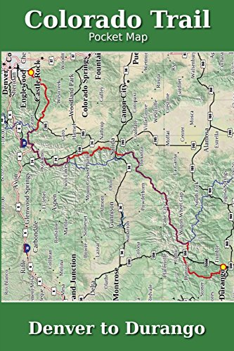
Major Update for 2018
The Colorado Trail Pocket Map is a complete and concise set of topographic maps created with digitized base maps covering every step of the 486 mile trail from Denver, CO to Durango, CO.
The land cover, hydrology and contour data used to create these maps has been collected within the last 5 years, presented in a completely uniform manner across all 74 maps. No other complete Colorado Trail map set available can say this!
Features:
+ Seamless. Uniform styles, colors, fonts and unit of measure.
+ 74 full color, digitized topographic maps
+ 10 distinct land cover shades for easily identifying terrain
+ Easily see road walks, dirt and paved
+ Beautiful 3D hill shading
+ Highly detailed elevation chart on each map
+ 6" x 9" (15.2cm x 22.9cm) format for easy pack stowage
+ Accumulated trail mileage every mile
+ Resupply locations within 90 miles of map center
+ 1:38,500 scale with decimal degree lat/long and UTM grids
+ Trail trace from ColoradoTrail.org
+ Maps extend to edge of paper
+ Clear overlap with Continental Divide Trail (magenta color)
These 6" x 9" full color topographic maps are designed to stow easily into your pack, without sacrificing the detail required by a hiker in the back country.
The Colorado Trail Pocket Map is a complete and concise set of topographic maps created with digitized base maps covering every step of the 482 mile trail from Denver, CO to Durango, CO.
The land cover, hydrology and contour data used to create these maps has been collected within the last 5 years, presented in a completely uniform manner across all 80 maps. No other complete Colorado Trail map set available can say this!
Features:
+ 80 full color, digitized topographic maps
+ Seamless. Uniform styles, colors, fonts and unit of measure.
+ Beautiful 3D hill shading
+ Highly detailed elevation chart on each map
+ Section overview maps
+ 6" x 9" (15.2cm x 22.9cm) format for easy pack stowage
+ Accumulated trail mileage every mile
+ Resupply locations within 90 miles of map center
+ 1:40,000 scale with WGS84 decimal degree tick marks
+ Data book information printed at each locale on the maps
+ Trail trace and waypoints from ColoradoTrail.org
+ Over 500 way points and resupply locations
+ FREE PDF Data Book available at Postholer.Com
These 6" x 9" full color topographic maps are designed to stow easily into your pack, without sacrificing the detail required by a hiker in the back country.
��ber diesen Titel� kann sich auf eine andere Ausgabe dieses Titels beziehen.
- VerlagCreateSpace Independent Publishing Platform
- Erscheinungsdatum2011
- ISBN 10 1468029053
- ISBN 13 9781468029055
- EinbandTapa blanda
- Anzahl der Seiten94
Neu kaufen
Mehr zu diesem Angebot erfahren
EUR 26,12
Versand:
EUR 3,27
Innerhalb der USA
Beste Suchergebnisse bei AbeBooks
Beispielbild f�r diese ISBN
Colorado Trail Pocket Map
Verlag:
CreateSpace Independent Publishing Platform
(2011)
ISBN 10: 1468029053
ISBN 13: 9781468029055
Neu
Paperback
Anzahl: 1
Anbieter:
Bewertung
Buchbeschreibung Paperback. Zustand: new. New. Bestandsnummer des Verk�ufers Wizard1468029053
Weitere Informationen zu diesem Verk�ufer | Verk�ufer kontaktieren
Neu kaufen
EUR 26,12
W�hrung umrechnen
Beispielbild f�r diese ISBN
Colorado Trail Pocket Map
Verlag:
CreateSpace Independent Publishing Platform
(2011)
ISBN 10: 1468029053
ISBN 13: 9781468029055
Neu
Paperback
Anzahl: 1
Anbieter:
Bewertung
Buchbeschreibung Paperback. Zustand: new. New Copy. Customer Service Guaranteed. Bestandsnummer des Verk�ufers think1468029053
Weitere Informationen zu diesem Verk�ufer | Verk�ufer kontaktieren
Neu kaufen
EUR 26,50
W�hrung umrechnen
Beispielbild f�r diese ISBN
Colorado Trail Pocket Map
Print-on-Demand
Anbieter:
Bewertung
Buchbeschreibung Paperback. Zustand: Brand New. 96 pages. 9.00x6.00x0.23 inches. This item is printed on demand. Bestandsnummer des Verk�ufers zk1468029053
Weitere Informationen zu diesem Verk�ufer | Verk�ufer kontaktieren
Neu kaufen
EUR 33,39
W�hrung umrechnen
Beispielbild f�r diese ISBN
Colorado Trail Pocket Map
Verlag:
CreateSpace Independent Publis
(2011)
ISBN 10: 1468029053
ISBN 13: 9781468029055
Neu
Paperback
Anzahl: 2
Anbieter:
Bewertung
Buchbeschreibung Paperback. Zustand: New. Brand New!. Bestandsnummer des Verk�ufers VIB1468029053
Weitere Informationen zu diesem Verk�ufer | Verk�ufer kontaktieren
Neu kaufen
EUR 56,91
W�hrung umrechnen