Verwandte Artikel zu Victorian Maps of England: The county and city maps...
Zu dieser ISBN ist aktuell kein Angebot verf�gbar.
Alle Exemplare der Ausgabe mit dieser ISBN anzeigen:
Cr�ticas:
'This large format volume is stupendous.' * Lets Talk! * 'This large-format map book perfectly exemplifies Victorian artistry in its awe-inspiring meticulousness.' * Geographical *
Rese�a del editor:
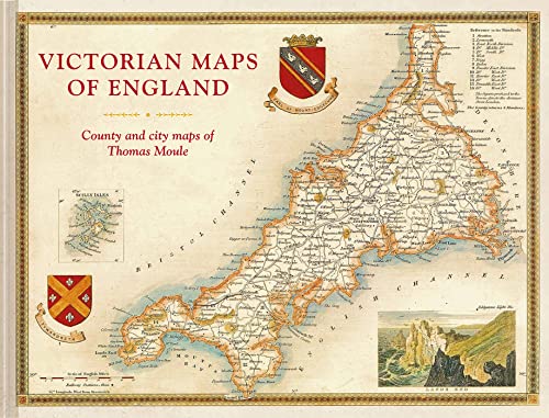
The most beautiful Victorian maps of England's counties and cities - in large format - by one of Britain's great cartographer's Thomas Moule. Thomas Moule was one of the finest Victorian mapmakers and is regarded as the true follower of John Speed in the cartographic history of Britain. Moule's beautifully observed county and city maps present a minutely detailed record of 19th-century England. They were first published in collectable parts between 1830 and 1837 and then published together in the extensive 2-volume masterwork The English Counties Delineated. Moule celebrated the `ancientness' and history of each county by including pastoral or monument views within the maps, all framed by cartouches, festoons and architectural ornament in a variety of historical styles. But underpinning this ancient vision is the hand of the British Industrial Revolution. Moule's maps are deeply informed by the early technical work of the Ordnance Survey and record the unstoppable growth of the major cities and the unrelenting spread of the railways. The maps have remained influential and highly collectable as both originals and as reproductions. For the first time in a generation this new large-format volume, comprising 55 county and city maps, presents the main body of Thomas Moule's work alongside his original detailed text descriptions. The book's Introduction explains Moule's career as a writer and antiquary and sets his celebrated maps in the context of the technical cartographic revolution in which they were published. The book examines the wide-ranging artistic and cultural influences exhibited as Moule combines accurate cartography with highly decorative architectural frames and evocative, Romantic, pastoral views of the England he so cherished. In doing so it positions him alongside his fellow celebrated Victorian pioneers, including George Virtue, William Westall, Walter Scott, Charles Dickens, JMW Turner, Augustus Pugin, Edward Stanford and George Bradshaw.
��ber diesen Titel� kann sich auf eine andere Ausgabe dieses Titels beziehen.
Neu kaufen
Mehr zu diesem Angebot erfahren
EUR 20,45
Versand:
EUR 3,69
Innerhalb der USA
Beste Suchergebnisse bei AbeBooks
Beispielbild f�r diese ISBN
Victorian Maps of England: The Country & City Maps of Thomas Moule
Anbieter:
Bewertung
Buchbeschreibung Zustand: New. Fine. Hardcover with pictorial boards. 2018. Bestandsnummer des Verk�ufers W120488b
Weitere Informationen zu diesem Verk�ufer | Verk�ufer kontaktieren
Neu kaufen
EUR 20,45
W�hrung umrechnen
Foto des Verk�ufers
Victorian Maps of England : The County and City Maps of Thomas Moule
Anbieter:
Bewertung
Buchbeschreibung Zustand: New. Bestandsnummer des Verk�ufers 31829080-n
Weitere Informationen zu diesem Verk�ufer | Verk�ufer kontaktieren
Neu kaufen
EUR 28,28
W�hrung umrechnen
Beispielbild f�r diese ISBN
Victorian Maps of England: The County And City Maps Of Thomas Moule
Anbieter:
Bewertung
Buchbeschreibung Hardcover. Zustand: New. Brand New!. Bestandsnummer des Verk�ufers 1849944970
Weitere Informationen zu diesem Verk�ufer | Verk�ufer kontaktieren
Neu kaufen
EUR 30,80
W�hrung umrechnen
Beispielbild f�r diese ISBN
Victorian Maps of England: The County And City Maps Of Thomas Moule
Anbieter:
Bewertung
Buchbeschreibung Zustand: New. . Bestandsnummer des Verk�ufers 52GZZZ00Y4WQ_ns
Weitere Informationen zu diesem Verk�ufer | Verk�ufer kontaktieren
Neu kaufen
EUR 31,47
W�hrung umrechnen
Beispielbild f�r diese ISBN
Victorian Maps of England: The County And City Maps Of Thomas Moule
Anbieter:
Bewertung
Buchbeschreibung Zustand: New. Book is in NEW condition. 4.5. Bestandsnummer des Verk�ufers 1849944970-2-1
Weitere Informationen zu diesem Verk�ufer | Verk�ufer kontaktieren
Neu kaufen
EUR 36,00
W�hrung umrechnen
Beispielbild f�r diese ISBN
Victorian Maps of England: The County And City Maps Of Thomas Moule
Anbieter:
Bewertung
Buchbeschreibung Zustand: New. New! This book is in the same immaculate condition as when it was published 4.5. Bestandsnummer des Verk�ufers 353-1849944970-new
Weitere Informationen zu diesem Verk�ufer | Verk�ufer kontaktieren
Neu kaufen
EUR 36,01
W�hrung umrechnen
Beispielbild f�r diese ISBN
Victorian Maps of England (Hardcover)
Verlag:
Batsford Ltd, London
(2018)
ISBN 10: 1849944970
ISBN 13: 9781849944977
Neu
Hardcover
Anzahl: 1
Anbieter:
Bewertung
Buchbeschreibung Hardcover. Zustand: new. Hardcover. The most beautiful Victorian maps of England's counties and cities by one of Britain's great cartographer's Thomas Moule. For the first time in a generation, the maps of the mid-19th century are reproduced to a very high standard in a large-format book. The maps are fascinating, decorative and hugely informative of an England in transformation with industrialization and the burgeoning railways. The 60 maps cover the counties of England plus key cities and are accompanied by contemporary descriptions as well as extracts on the counties from the Victorian age. It explores and explains Moule's career and development as a mapmaker and positions him alongside fellow celebrated Victorian pioneers including Brunel, Wedgewood, Bradshaw, Turner, Pugin, Blake, Scott and Wordsworth. Thomas Moule (1784-1851) is the finest Victorian mapmaker and is regarded as the true follower of John Speed in the cartographic history of Britain. Moule's beautifully observed county and city maps present a minutely detailed record of nineteenth-century England whilst also celebrating its 'ancientness' and history through pastoral or monument views all of which are framed within the cartouches, festoons and architecural ornament of the time. All, however, also show the progress of the Industrial revolution. The maps have remained most influential and highly collectable in both original and as reproductions. The most beautiful Victorian maps of England's counties and cities - in large format - by one of Britain's great cartographer's Thomas Moule. Shipping may be from multiple locations in the US or from the UK, depending on stock availability. Bestandsnummer des Verk�ufers 9781849944977
Weitere Informationen zu diesem Verk�ufer | Verk�ufer kontaktieren
Neu kaufen
EUR 36,03
W�hrung umrechnen
Beispielbild f�r diese ISBN
Victorian Maps of England: County and City Maps of Thomas Moule
Anbieter:
Bewertung
Buchbeschreibung Zustand: New. Bestandsnummer des Verk�ufers 26383952111
Weitere Informationen zu diesem Verk�ufer | Verk�ufer kontaktieren
Neu kaufen
EUR 33,08
W�hrung umrechnen
Beispielbild f�r diese ISBN
Victorian Maps of England: County and City Maps of Thomas Moule
Anbieter:
Bewertung
Buchbeschreibung Zustand: New. Bestandsnummer des Verk�ufers 378870576
Weitere Informationen zu diesem Verk�ufer | Verk�ufer kontaktieren
Neu kaufen
EUR 32,41
W�hrung umrechnen
Beispielbild f�r diese ISBN
Victorian Maps of England: County and City Maps of Thomas Moule
Anbieter:
Bewertung
Buchbeschreibung Hardcover. Zustand: New. Special order direct from the distributor. Bestandsnummer des Verk�ufers ING9781849944977
Weitere Informationen zu diesem Verk�ufer | Verk�ufer kontaktieren
Neu kaufen
EUR 33,24
W�hrung umrechnen