Verwandte Artikel zu Bradshaw's Railway Folded Map 1907
Zu dieser ISBN ist aktuell kein Angebot verf�gbar.
Alle Exemplare der Ausgabe mit dieser ISBN anzeigen:
Unusual book
Die Inhaltsangabe kann sich auf eine andere Ausgabe dieses Titels beziehen.
Rese�a del editor:
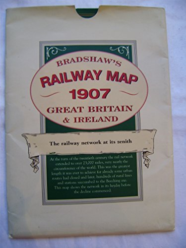
A detailed map of the railway network at its zenith. At the turn of the twentieth century the rail network in Britain and Ireland extended to over 23,000 miles, very nearly the circumference of the world. This was the greatest length it was ever to achieve for already some urban routes had lost the fight with electric trams and, later, culminating in the Beeching axe, hundreds of rural lines and stations were closed. This map shows the network in its heyday before the decline commenced. This map shows lines in England, Scotland, Wales and Ireland with detailed enlargements of the major conurbations. The great main lines with major stations and termini are marked as well as many small village halts on the humble country branch lines. The map bears witness to the culmination of the gargantuan engineering feat which produced 23,000 route miles in the 82 years since the first 25 miles of railway was completed between Stockton and Darlington in 1825. Compare that to the less than 11,000 miles we have a century later and use the map to explore the hundreds of routes, with their stations, which ran through so many parts of the country but survived for no more than a few generations before succumbing to the march of progress which favoured alternative means of transport.
��ber diesen Titel� kann sich auf eine andere Ausgabe dieses Titels beziehen.
- VerlagOld House Books
- Erscheinungsdatum2004
- ISBN 10 1873590334
- ISBN 13 9781873590331
- EinbandMapa
- Anzahl der Seiten1
- Bewertung
Gebraucht kaufen
Zustand: AusreichendA readable copy of the book which... Mehr zu diesem Angebot erfahren

EUR 2,58
Versand:
EUR 5,59
Von Vereinigtes K�nigreich nach USA
Beste Suchergebnisse bei AbeBooks
Beispielbild f�r diese ISBN
Bradshaw's Railway Folded Map 1907
Verlag:
Old House Books
(2006)
ISBN 10: 1873590334
ISBN 13: 9781873590331
Gebraucht
Paperback
Anzahl: 1
Anbieter:
Bewertung
Buchbeschreibung Paperback. Zustand: Fair. A readable copy of the book which may include some defects such as highlighting and notes. Cover and pages may be creased and show discolouration. Bestandsnummer des Verk�ufers GOR002004436
Weitere Informationen zu diesem Verk�ufer | Verk�ufer kontaktieren
Gebraucht kaufen
EUR 2,58
W�hrung umrechnen
Foto des Verk�ufers
Bradshaw's Railway Folded Map 1907
Anbieter:
Bewertung
Buchbeschreibung Zustand: VeryGood. Most items will be dispatched the same or the next working day. Bestandsnummer des Verk�ufers wbs2716322242
Weitere Informationen zu diesem Verk�ufer | Verk�ufer kontaktieren
Gebraucht kaufen
EUR 0,92
W�hrung umrechnen
Foto des Verk�ufers
Bradshaw's Railway Folded Map 1907
Anbieter:
Bewertung
Buchbeschreibung Zustand: Good. Most items will be dispatched the same or the next working day. Bestandsnummer des Verk�ufers wbs5119553082
Weitere Informationen zu diesem Verk�ufer | Verk�ufer kontaktieren
Gebraucht kaufen
EUR 0,92
W�hrung umrechnen
Beispielbild f�r diese ISBN
Bradshaw's Railway Folded Map 1907
Verlag:
Bloomsbury Publishing PLC, United Kingdom, London
(2004)
ISBN 10: 1873590334
ISBN 13: 9781873590331
Gebraucht
Paperback
Anzahl: 5
Anbieter:
Bewertung
Buchbeschreibung Paperback. Zustand: Very Good. A detailed map of the railway network at its zenith. At the turn of the twentieth century the rail network in Britain and Ireland extended to over 23,000 miles, very nearly the circumference of the world. This was the greatest length it was ever to achieve for already some urban routes had lost the fight with electric trams and, later, culminating in the Beeching axe, hundreds of rural lines and stations were closed. This map shows the network in its heyday before the decline commenced. This map shows lines in England, Scotland, Wales and Ireland with detailed enlargements of the major conurbations. The great main lines with major stations and termini are marked as well as many small village halts on the humble country branch lines. The map bears witness to the culmination of the gargantuan engineering feat which produced 23,000 route miles in the 82 years since the first 25 miles of railway was completed between Stockton and Darlington in 1825. Compare that to the less than 11,000 miles we have a century later and use the map to explore the hundreds of routes, with their stations, which ran through so many parts of the country but survived for no more than a few generations before succumbing to the march of progress which favoured alternative means of transport. The book has been read, but is in excellent condition. Pages are intact and not marred by notes or highlighting. The spine remains undamaged. Bestandsnummer des Verk�ufers GOR001697976
Weitere Informationen zu diesem Verk�ufer | Verk�ufer kontaktieren
Gebraucht kaufen
EUR 5,16
W�hrung umrechnen
Bradshaw's Railway Map 1907 : Great Britain & Ireland
Anbieter:
Bewertung
Buchbeschreibung paperback. Zustand: Very Good. No Jacket. folding paper map in very good condition, housed in a paper wallet which is chipped at one corner, Bestandsnummer des Verk�ufers 267831
Weitere Informationen zu diesem Verk�ufer | Verk�ufer kontaktieren
Gebraucht kaufen
EUR 7,02
W�hrung umrechnen
Foto des Verk�ufers
Bradshaw's Railway Map 1907 Great Britain & Ireland
Verlag:
Old House Books, Moretonhampstead
(2004)
ISBN 10: 1873590334
ISBN 13: 9781873590331
Gebraucht
Anzahl: 1
Anbieter:
Bewertung
Buchbeschreibung Map-folded. Zustand: Near Fine. Very lightly marked wallet else as new. Folded map with booklet. Bestandsnummer des Verk�ufers C355
Weitere Informationen zu diesem Verk�ufer | Verk�ufer kontaktieren
Gebraucht kaufen
EUR 5,99
W�hrung umrechnen
Bradshaw's Railway Folded Map 1907 PLUS 1897 London Railways Map PLUS Isambard Kingdom Brunel
Anbieter:
Bewertung
Buchbeschreibung No Binding. Zustand: Very Good. 2 maps plus one booklet. Bestandsnummer des Verk�ufers 73632
Weitere Informationen zu diesem Verk�ufer | Verk�ufer kontaktieren
Gebraucht kaufen
EUR 11,99
W�hrung umrechnen
Bradshaw's Railway Map, 1907 : Great Britain and Ireland
Verlag:
Old House Books, Moretonhampstead, UK
(2006)
ISBN 10: 1873590334
ISBN 13: 9781873590331
Gebraucht
Soft cover
Anzahl: 1
Anbieter:
Bewertung
Buchbeschreibung Soft cover. Zustand: Very Good. Large fold-out map showing the network in its heyday, before the decline commenced with detailed enlargements of the major conurbations. Very good clean copy. Bestandsnummer des Verk�ufers 009238
Weitere Informationen zu diesem Verk�ufer | Verk�ufer kontaktieren
Gebraucht kaufen
EUR 11,99
W�hrung umrechnen
Beispielbild f�r diese ISBN
Bradshaw's Railway Folded Map 1907
Anbieter:
Bewertung
Buchbeschreibung Map. Zustand: Fine. some shelf wear but the content new throughout. Bestandsnummer des Verk�ufers 124443-4
Weitere Informationen zu diesem Verk�ufer | Verk�ufer kontaktieren
Gebraucht kaufen
EUR 9,59
W�hrung umrechnen
Beispielbild f�r diese ISBN
Bradshaw's Railway Folded Map 1907
Anbieter:
Bewertung
Buchbeschreibung map. Zustand: Very Good. Bestandsnummer des Verk�ufers mon0000067201
Weitere Informationen zu diesem Verk�ufer | Verk�ufer kontaktieren
Gebraucht kaufen
EUR 5,40
W�hrung umrechnen