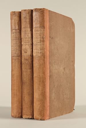
ACCOUNT OF AN EXPEDITION FROM PITTSBURGH TO THE ROCKY MOUNTAINS, PERFORMED IN THE YEARS 1819, 1820.UNDER THE COMMAND OF MAJ. S.H. LONG, OF THE U.S. TOP. ENGINEERS. COMPILED FROM THE NOTES OF MAJOR LONG, MR. T. SAY, AND OTHER GENTLEMEN OF THE PARTY, BY EDWIN JAMES, BOTANIST AND GEOLOGIST TO THE EXPEDITION
James, Edwin
Verkäufer
William Reese Company - Americana, New Haven, CT, USA
Verkäuferbewertung 4 von 5 Sternen
![]()
AbeBooks-Verkäufer seit 13. Juli 2006
Beschreibung
Beschreibung:
Three volumes. vii,[1],344; vii,[1],356; vii,[1],347,[1]pp. Folding engraved map, folding engraved plate with geological profiles, and eight other plates (three aquatint) by I. Clark after S. Seymour. Half title in second and third volumes. Original publisher's half cloth and plain paper boards, printed paper labels. Neat repair to hinges and corners. Bookplate on front pastedown of first volume. Quite clean internally. About very good. Untrimmed. The first London edition of this cornerstone of Western Americana. Originally named the "Yellowstone Expedition," the U.S. government expedition under Major Stephen Long was the most ambitious exploration of the trans- Mississippi West following those of Lewis and Clark and Zebulon Pike. The expedition travelled up the Missouri and then followed the River Platte to its source in the Rocky Mountains before moving south to Upper Arkansas. From there the plan was to find the source of the Red River, but when this was missed, the Canadian River was explored instead. Edwin James was the botanist, geologist, and surgeon for the expedition, and "based his compilation upon his own records, the brief geological notes of Major Long, and the early journals of Thomas Say [who served as the expedition's zoologist]" (Wagner-Camp). Significantly, Long's expedition was the first official U.S. expedition to be accompanied by artists (namely Titian Peale and Samuel Seymour), and the illustrations are an important early visual record of the region. Cartographically, Long provided the first details of the Central Plains. Upon returning to Washington from the expedition, he drafted a large manuscript map of the West (now in the National Archives) and the printed map in James' ACCOUNT. closely follows his original. The myth of the Great American Desert was founded by Long, a myth which endured for decades. Long's map, along with that of Lewis and Clark, "were the progenitors of an entire class of maps of the American Transmississippi West" (Wheat). The American first edition was published in three volumes in Philadelphia in 1822-23; this London edition followed. The London edition differs in some respects from the American: a few additional paragraphs of text were added, the plates were re-engraved, and the two maps found in the American edition were here combined into one. WAGNER-CAMP 25:2. FIELD 948. ABBEY 650. HOWES J41, "b." STREETER SALE 1784. WHEAT TRANSMISSISSIPPI 353. SABIN 35683. REESE, BEST OF THE WEST 49 (ref). Bestandsnummer des Verkäufers WRCAM52112A
Bibliografische Details
Titel: ACCOUNT OF AN EXPEDITION FROM PITTSBURGH TO ...
Verlag: Longman, Hurst, Rees, Orme & Brown, London
Erscheinungsdatum: 1823
Beste Suchergebnisse bei AbeBooks
ACCOUNT OF AN EXPEDITION FROM PITTSBURGH TO THE ROCKY MOUNTAINS, PERFORMED IN THE YEARS 1819, 1820.UNDER THE COMMAND OF MAJ. S.H. LONG, OF THE U.S. TOP. ENGINEERS. COMPILED FROM THE NOTES OF MAJOR LONG, MR. T. SAY, AND OTHER GENTLEMEN OF THE PARTY, BY EDWIN JAMES, BOTANIST AND GEOLOGIST TO THE EXPEDITION.
Anbieter: William Reese Company - Americana, New Haven, CT, USA
The first London edition of this cornerstone of Western Americana. Originally named the "Yellowstone Expedition," the U.S. government expedition under Major Stephen Long was the most ambitious exploration of the trans-Mississippi West following those of Lewis and Clark and Zebulon Pike. The expedition travelled up the Missouri and then followed the River Platte to its source in the Rocky Mountains before moving south to Upper Arkansas. From there the plan was to find the source of the Red River, but when this was missed, the Canadian River was explored instead. Edwin James was the botanist, geologist, and surgeon for the expedition, and "based his compilation upon his own records, the brief geological notes of Major Long, and the early journals of Thomas Say [who served as the expedition's zoologist]" (Wagner-Camp). Significantly, Long's expedition was the first official U.S. expedition to be accompanied by artists (namely Titian Peale and Samuel Seymour), and the illustrations are an important early visual record of the region. Cartographically, Long provided the first details of the Central Plains. Upon returning to Washington from the expedition, he drafted a large manuscript map of the West (now in the National Archives) and the printed map in James' ACCOUNT. closely follows his original. The myth of the Great American Desert was founded by Long, a myth which endured for decades. Long's map, along with that of Lewis and Clark, "were the progenitors of an entire class of maps of the American Transmississippi West" (Wheat). The American first edition was published in three volumes in Philadelphia in 1822-23; this London edition followed. The London edition differs in some respects from the American: a few additional paragraphs of text were added, the plates were re-engraved, and the two maps found in the American edition were here combined into one. WAGNER-CAMP 25:2. FIELD 948. ABBEY 650. HOWES J41, "b." STREETER SALE 1784. WHEAT TRANSMISSISSIPPI 353. SABIN 35683. REESE, BEST OF THE WEST 49 (ref). Half title in second and third volumes. Original publisher's half cloth and plain paper boards, printed paper labels. Neat repair to hinges and corners. Bookplate on front pastedown of first volume. Quite clean internally. About very good. Untrimmed. Bestandsnummer des Verkäufers 58156
Anzahl: 1 verfügbar


