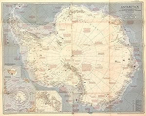
Antarctica
NATIONAL GEOGRAPHIC SOCIETY
Verkäufer
Argosy Book Store, ABAA, ILAB, New York, NY, USA
Verkäuferbewertung 4 von 5 Sternen
![]()
Heritage Bookseller
AbeBooks-Mitglied seit 1996
Beschreibung
Beschreibung:
Map. Full-color lithograph. Sheet measures 23 3/4" x 21 1/2" Fascinating map of Antarctica. Highly detailed with notations describing the extent of international expeditions on the continent, with flags representing their respective stations. It features an Azimuthal Equidistant Projection executed by James M. Darly, Chief Cartographer, under the editor Melville Bell Grosvenor. Appeared in the September 1957 issue of National Geographic Magazine. This map is in good condition, with minor toning and wear along original fold lines. Bestandsnummer des Verkäufers 319107
Bibliografische Details
Titel: Antarctica
Verlag: National Geographic Society, Washington, D.C.
Erscheinungsdatum: 1957
Einband: unbound
Beste Suchergebnisse bei AbeBooks
National Geographic Destinations, Antarctica the Last Continent
Anbieter: Once Upon A Time Books, Siloam Springs, AR, USA
paperback. Zustand: Good. This is a used book in good condition and may show some signs of use or wear . This is a used book in good condition and may show some signs of use or wear . Bestandsnummer des Verkäufers mon0001218147
Anzahl: 1 verfügbar
Antarctica
Anbieter: Ken's Book Haven, Coopersburg, PA, USA
Zustand: VG. Map only. Bestandsnummer des Verkäufers KENSBOOK005686
Anzahl: 1 verfügbar
National Geographic Destinations, Antarctica the Last Continent
Anbieter: BooksRun, Philadelphia, PA, USA
Paperback. Zustand: Good. Ship within 24hrs. Satisfaction 100% guaranteed. APO/FPO addresses supported. Bestandsnummer des Verkäufers 0792274547-11-1
Anzahl: 1 verfügbar
National Geographic Map & Supplement, 'Antarctica - A New Age of Exploration'. From the February, 2002 Issue
Anbieter: Singularity Rare & Fine, Baldwinsville, NY, USA
Soft cover. Zustand: Near Fine. Near Fine; see scans and descriptionWashington, DC: National Geographic Society, 2002. Sixteen-fold Map and supplement, 'Antarctica - A New Age of Exploration'. From the February, 2002 Issue of National Geographic magazine. Approx 31" x 20". Near Fine; a corner crease affects, but does not damage, 8 of the 16 sections created by the sixteen-fold format (for magazine insertion); trace micro-wear at one fold seam, else bright, crisp. Never opened but for description and scanning. See frontal folded scan, and partial scan of the upper left portion of the map side. Full map of the Antarctic, as of 2002, on the obverse; continued graphics with text and other information on the topic on reverse side. L43n. Bestandsnummer des Verkäufers 61371
Anzahl: 1 verfügbar
National Geographic Destinations, Antarctica the Last Continent
Anbieter: Toscana Books, AUSTIN, TX, USA
Paperback. Zustand: very good. Purchase pre-owned books for prompt service and customer satisfaction. Bestandsnummer des Verkäufers UnScanned0792274547
Anzahl: 1 verfügbar
National Geographic Destinations, Antarctica the Last Continent
Anbieter: Books Unplugged, Amherst, NY, USA
Zustand: Good. Buy with confidence! Book is in good condition with minor wear to the pages, binding, and minor marks within 1.6. Bestandsnummer des Verkäufers bk0792274547xvz189zvxgdd
Anzahl: 1 verfügbar
The National Geographic Magazine - six articles bound together in cloth - Peary as a Leader, To Seek the Unknown in the Arctic, The MacMillan Arctic Expedition Returns, The First Flight to the North Pole, Navigating the "Norge" from the North Pole and Beyond, Exploring the Ice Age in Antarctica
Anbieter: COLLINS BOOKS, Seattle, WA, USA
HARDCOVER. Hardcover edition. Varia paginated. Large 8vo in brown hardcover. A nicely bound collection of six articles on the Arctic and Antarctic, issued between 1920 and 1935. Corner wear, else very light wear. Contents clean and crisp. Very Good. Bestandsnummer des Verkäufers 121296
Anzahl: 1 verfügbar
National Geographic Destinations, Antarctica the Last Continent
Anbieter: Save With Sam, North Miami, FL, USA
paperback. Zustand: New. 1.2000. Bestandsnummer des Verkäufers VIB0792274547
Anzahl: 1 verfügbar
Antarctica Compiled and Drawn in the Cartographic Division of the National Geographic Society. September 1957
Anbieter: libreria antiquaria perini Sas di Perini, Verona, VR, Italien
Mappa dellíAntartide preparata per celebrare due recenti spedizioni americane, líOperazione Deep Freeze dellíammiraglio George Dufek, che raggiunse il Polo Sud il 31 ottobre 1956 e la spedizione di Paul Siple (1856-1858), che conduesse esperimenti con un soggiorno di 18 mesi al Polo Sud. La mappa fornisce uníottima panoramica dellíestensione indicando con bandiere le stazioni mantenute da diverse nazioni. Include molte note storiche riguardanti la scoperta e líesplorazione del continente e mostra inoltre venti, correnti oceaniche, ghiacciai. Ottimo esemplare in perfetto stato di conservazione.Map of Antarctica prepared to celebrate two recent American expeditions, Admiral George Dufekís Operation Deep Freeze, which reached the South Pole on October 31, 1956, and Paul Sipleís (1856-1858) expedition, which conducted experiments with a living room of 18 months at the South Pole. The map gives a very good overview of the extent by flagging stations maintained by different nations. It includes many historical notes regarding the discovery and exploration of the continent and also shows winds, ocean currents, glaciers. Nr.cat: Cod 7661. Bestandsnummer des Verkäufers 13097
Anzahl: 1 verfügbar


