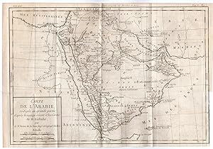
Antique Map-ARABIA-MIDDLE EAST-Anonymous-Brion de la Tour-1779
Anonymous
Verkäufer Pictura Prints, Art & Books, Overasselt, Niederlande
Verkäuferbewertung 5 von 5 Sternen
AbeBooks-Verkäufer seit 1. November 2019
Verkäufer Pictura Prints, Art & Books, Overasselt, Niederlande
Verkäuferbewertung 5 von 5 Sternen
AbeBooks-Verkäufer seit 1. November 2019
Beschreibung
'CARTE DE L'ARABIE, REDIGEE EN GRANDE PARTIE D'APRES LE VOYAGE RECENT ET LES CARTES DE M. NIEBUHR", BRION DE LA TOUR''This print shows a map of the Arabian Peninsula. The map extends to show Beirut, Damascus, the Holy Land, Cairo, the Nile, and southern Persia, but most of the detail is concentrated on the peninsula. There are plenty of place names and nice topographical detail. Two distance scales are enclosed in the simple block title cartouche at bottom left.Made by Anonymous after Louis Brion de la Tour.Medium: Engraving on hand laid (verge) paper.Sheet size: 36.7 x 25 cm (14.45 x 9.84 inch). Image size: 34 x 23.5 cm. (13.39 x 9.25 inch).ARABIA-MIDDLE EAST | RBOS-A8-27BACKGROUND INFORMATIONThis attractive print was published in the atlas Histoire Universal. Part. Mod., Tom 69 pag.1 in France, ca. 1780, by Brion de la Tour. This map is based on Carsten Niebuhr's travels with the Danish Arabia expedition (1761-67). .Biography artist: Cartographer: Louis Brion de la Tour (1756-1823) was the Cartographer Royal to the King of France. There is little information about his life. His official title was "King's Engineer Geographer." Although he is a prolific geographer, very little is currently known of his life or his career. His life was spent in scientific work. However what is known is an important part of his work was done in collaboration with Louis Charles Desnos (1750-1790 to) a bookseller and geographical engineer for the globes and spheres of His Danish Majesty. His son Louis Brion de la Tour, a pupil of Jean-Bernard Restout, was engraver of maps and documents of the Revolution, and was also an occasional portrait oil paintings. Condition: good, given age. Folds as published. Right margin paper loss. Fold in lower right margin. Ghosting from map binding. General age-related toning and/or occasional minor defects from handling. Please study scan carefully. Bestandsnummer des Verkäufers RB-2389
Bibliografische Details
Titel: Antique Map-ARABIA-MIDDLE ...
Erscheinungsdatum: 1779
Illustrator: Louis Brion de la Tour
Anbieterinformationen
Pictura Prints guarantees the items to be as described. We always add scans or photographs to our listings. Further information is possibly available on request. Certificates of autenticity (COA) can be provided on request. We use a margin tax treatment.
We ship worldwide and package our items meticulously. We carry an umbrella insurance policy. Our shipment rates are based on shipments up to 1 kg. For heavier shipments we will contact you with a quote. Currently our surcharge for international shipments over 1 kg is 9,14 euro / kg. In addition POST NL temporarly charges 3,60 euro per kg due to CORONA related logistics. We ship by registered mail through POST NL. Expedited shipping or shipment through another carrier is available on request at a possible surcharge.
Zahlungsarten
akzeptiert von diesem Verkäufer