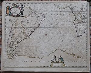
Antique Map-ATLANTIC OCEAN-AFRICA-SOUTH AMERICA-ANTARCTICA-Janssonius-c.1650
Verkäufer Pictura Prints, Art & Books, Overasselt, Niederlande
Verkäuferbewertung 5 von 5 Sternen
AbeBooks-Verkäufer seit 1. November 2019
Verkäufer Pictura Prints, Art & Books, Overasselt, Niederlande
Verkäuferbewertung 5 von 5 Sternen
AbeBooks-Verkäufer seit 1. November 2019
Beschreibung
Engraving with contemporary hand colouring on hand laid (verge) paper. on paper. Size in cm: The overall size is ca. 59 x 47.5 cm. The image size is ca. 56 x 44 cm. Size in inch: The overall size is ca. 23.2 x 18.7 inch. The image size is ca. 22 x 17.3 inch.Antique map, titled: 'Mar di Aethiopia vulgo Oceanus Aethiopicus.' - A map of the southern half Atlantic Ocean, between Africa and South America and bordered by 'Terra Australis Incognita' on the south. With a decorative cartouche featuring natives, birds and lizards. Additional decoration around the scale bar. From: "Atlantis Majoris Quinta Pars Orbem Maritimum seu. by Johannes Janssonius, 1650.Artists and Engravers: Made by an anonymous engraver after 'Johannes Janssonius'. Johannes Janssonius also known as Jan Jansson (1588-1664) was born in Arnhem, Netherlands. His father was a bookseller and publisher (Jan Janszoon the Elder). When he married the daughter of the cartographer Jodocus Hondius he also set up a business as book publisher in Amsterdam. His first map was published in 1616. Around 15 years later he set up a partnership with his brother in law Hondius add issued further editions of the Mercator/Hondius atlas. After his death his heirs still have published several maps. Many of his plates have been acquired by Pieter Schenk and Gerard Valk.Condition: Very good, given age. Original middle fold (as issued). Printed text on the rear, as issued. A small tear in the top left margin (not affecting image). Sheet overall slightly browned. A few small stains in the image area. General age-related toning and/or occasional minor defects from handling. Please study scan carefully.Keywords: ANTIQUE MAP-ATLANTIC OCEAN-AFRICA-SOUTH AMERICA-ANTARCTICA-JANSSONIUS(PCO) GK-299. Bestandsnummer des Verkäufers IMG_0299-2
Bibliografische Details
Titel: Antique Map-ATLANTIC OCEAN-AFRICA-SOUTH ...
Verlag: c.1650
Erscheinungsdatum: 1650
Anbieterinformationen
Pictura Prints guarantees the items to be as described. We always add scans or photographs to our listings. Further information is possibly available on request. Certificates of autenticity (COA) can be provided on request. We use a margin tax treatment.
We ship worldwide and package our items meticulously. We carry an umbrella insurance policy. Our shipment rates are based on shipments up to 1 kg. For heavier shipments we will contact you with a quote. Currently our surcharge for international shipments over 1 kg is 9,14 euro / kg. In addition POST NL temporarly charges 3,60 euro per kg due to CORONA related logistics. We ship by registered mail through POST NL. Expedited shipping or shipment through another carrier is available on request at a possible surcharge.
Zahlungsarten
akzeptiert von diesem Verkäufer