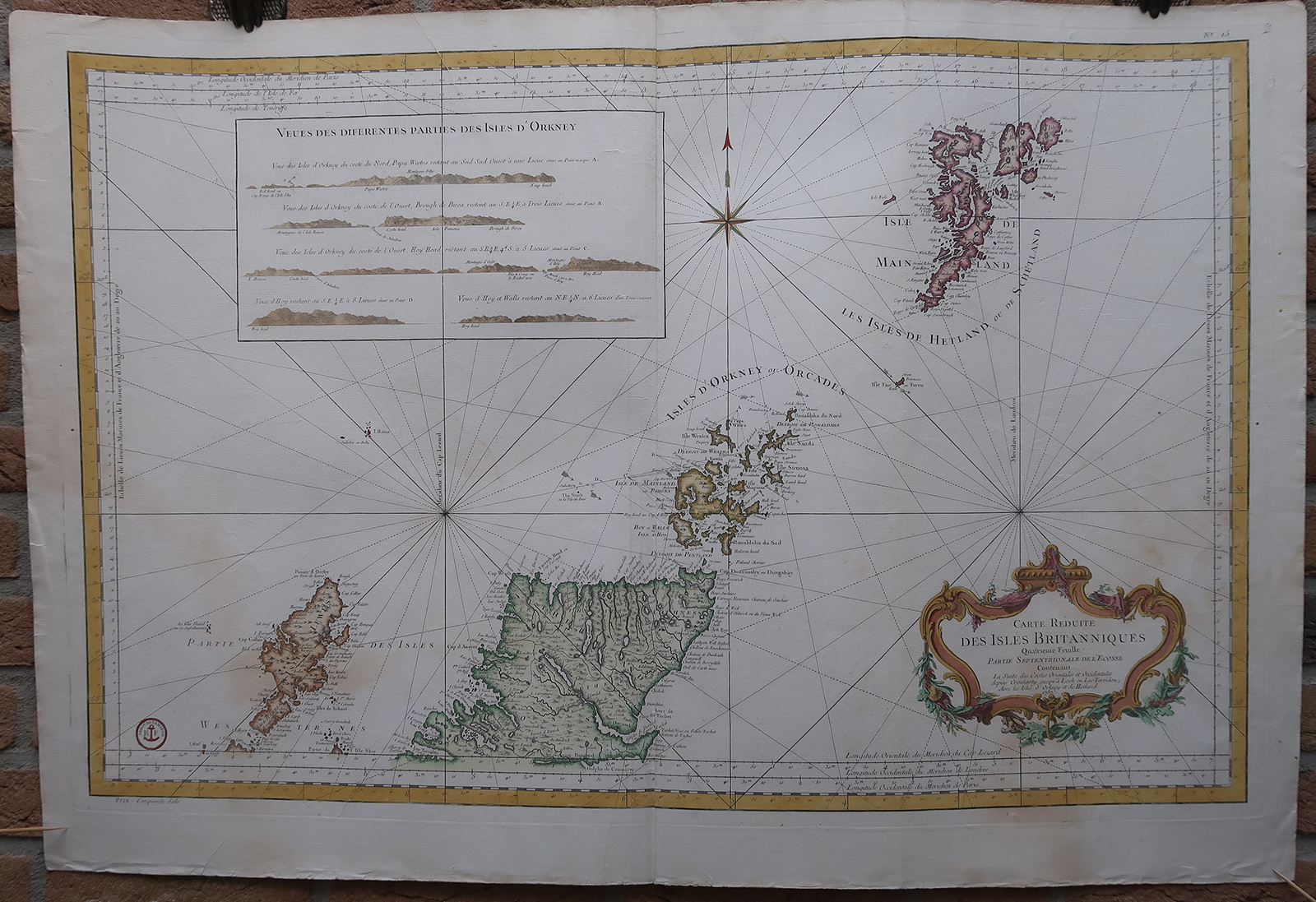
Antique map-SEA CHART-SCOTLAND-ORKNEY-SHETLAND-Bellin-Depot de la Marine-1765
Verkäufer Pictura Prints, Art & Books, Overasselt, Niederlande
Verkäuferbewertung 5 von 5 Sternen
AbeBooks-Verkäufer seit 1. November 2019
Verkäufer Pictura Prints, Art & Books, Overasselt, Niederlande
Verkäuferbewertung 5 von 5 Sternen
AbeBooks-Verkäufer seit 1. November 2019
Beschreibung
Engraving, handcoloured on hand laid paper. on paper. Size in cm: The overall size is ca. 94.2 x 64.4 cm. The image size is ca. 86.8 x 55.8 cm. Size in inch: The overall size is ca. 37.1 x 25.4 inch. The image size is ca. 34.2 x 22 inch.Antique map, titled: 'Carte Reduite des Isles Britanniques Quatrieme Feuille Partie Septentrionale de l'Ecosse [â ¦].' - A sea chart/map of Northern Scotland, showing Lewis and Harris, the Orkney Islands and the Shetland islands, as well as the area from Dingwall and Dornoch North. A few depth soundings and some current directions are indicated. A decorative cartouche in the lower right. Published by the Depot de la Marine. From: 'L'Hydrographie Francoise Recueil des Cartes Generales et Particulieres qui ont ete Faites pour le Service des Vaisseaux du Roy. Par ordre des Ministres de la Marine depuis 1737. jusqu'en 1765.' Par le S. Bellin Ingenieur de la Marine et du Depost des Cartes, Plans et Journaux de la Marine, Censeur Royal, de l'Academie de Marine et de la Societe Royale de Londres.Artists and Engravers: Made by an anonymous engraver after 'Jacques-Nicolas Bellin'. Jacques-Nicolas Bellin (1703-1772) was one of the most important cartographers of the 18th century. With a career spanning some 50 years, Bellin is best understood as geographe de cabinet and transitional mapmaker spanning the gap between 18th and early 19th century cartographic styles. His long career as Hydrographer and Ingà nieur Hydrographe at the French Dà pà t des cartes et plans de la Marine resulted in hundreds of high quality nautical charts of practically everywhere in the world.Condition: Very good, given age. Original middle fold, as issued. The lower half of the sheet faintly dampstained, mainly visible on verso. Creasing along the middle fold. Small tears and creasing in the margins (not affecting image). General age-related toning and/or occasional minor defects from handling. Please study scan carefully.Keywords: ANTIQUE MAP-SEA CHART-SCOTLAND-ORKNEY-SHETLAND-BELLIN-DEPOT DE LA MARINE(PCO) GK-063. Bestandsnummer des Verkäufers IMG_0063-2
Bibliografische Details
Titel: Antique map-SEA ...
Erscheinungsdatum: 1765
Anbieterinformationen
Pictura Prints guarantees the items to be as described. We always add scans or photographs to our listings. Further information is possibly available on request. Certificates of autenticity (COA) can be provided on request. We use a margin tax treatment.
We ship worldwide and package our items meticulously. We carry an umbrella insurance policy. Our shipment rates are based on shipments up to 1 kg. For heavier shipments we will contact you with a quote. Currently our surcharge for international shipments over 1 kg is 9,14 euro / kg. In addition POST NL temporarly charges 3,60 euro per kg due to CORONA related logistics. We ship by registered mail through POST NL. Expedited shipping or shipment through another carrier is available on request at a possible surcharge.
Zahlungsarten
akzeptiert von diesem Verkäufer