Beschreibung
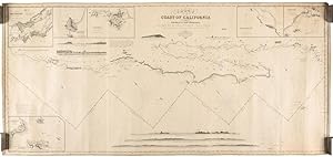
IMRAY, James (1803 1870). Chart of the Coast of California from San Blas to San Francisco Drawn Chiefly from the Spanish Surveys, the Charts of Vancouver, etc. The Whole Much Improved by Recent Observations made by English and French Naval Officers. London: Published by James Imray, Chart and Nautical Book Publisher, 102 Minories,1849. 2 sheets joined (26 4/8 x 56 6/8 inches). Fine engraved chart of the West Coast of California from the harbour of San Blas in Mexico to north of San Francisco Bay, with the Gulf of California and the Baja peninsula, with 6 insets of bays and 8 coastal profiles, with 3 compass roses, lines of latitude and longitude, laid down on blue paper for rolling, trimmed with linen (some pale waterstaining). Provenance: sold by Benj. Loring & Co. of Boston, with their printed label on the verso; with a few manuscript additions of a ship's course approaching San Francisco Bay with the dates 30th April 1854 and 1st of May; with Randall House, 12/80; from the important cartographical library of Warren Heckrotte, his sale, Rare Cartography, Exploration and Voyages, Part II, December 3, 2015, Lot 172 A fine and detailed and large-scale map of the West Coast of California from the harbour of San Blas in Mexico to north of San Francisco Bay, with the Gulf of California and the Baja peninsula, with insets of: "Entrance of San Francisco Harbour"; "Harbour of San Francisco By Capn. F.W. Beechey R.N. F.R.S."; and "Bay of Monterey By M. de Tessan of the French Navy", and also of Magdalen Bay, Mazatlan, and Guaymas. Warren Heckrotte asserts that "This was probably the best chart of the West Coast available in 1849." This is Chart No 8, "being the continuation of a series of charts for the navigation of the East and West Coast of America: No.1 The Coast of Columbia and Caribbean Sea No.2 The North Coast of Brazil No.3 The Coast of Brazil, from the Equator to Rio Janeiro No.4 The Coast of Brazil, from Cape Frio to the River Plate No.5 River Plate to Valparaiso No.6 Valparaiso to Lima and Panama No. 7 Western Coast of North America, from Nicoya to San Blas. King, Western Hist. Quarterly X, pp 283-302. "Imray's own particular interest was in chart compilation and he expanded his list beyond home trade waters with new charts of American and eastern seas. The publication of sailing directions, the manufacture and sale of nautical instruments (with which the firm had widened its services to navigators), and the nautical academy all flourished. In 1854, when his elder son, James Frederick Imray (1829 1891), became a partner in the book and instrument sides of the business, the firm became James Imray & Son. "By the 1860s Imray had become the leading British commercial chart publisher and was operating from three premises: 89 Minories housed chart publication, 102 Minories chart and books sales and the nautical academy, and 1 Postern Row the instrument shop. The majority of the fast-growing British merchant fleet used his charts because, although accurate Admiralty charts were now available, merchant shipmasters still preferred the charts of commercial publishers, named blue backs from their distinctive blue paper backing, and particularly James Imray's blue backs. They were popular because they retained the traditional format of a small-scale general chart with many large-scale insets of harbours. They were designed to answer the needs of a particular voyage conveniently and used modern survey material, now available from Admiralty and foreign government charts. They were more expensive than Admiralty charts, but fewer of them were needed because for some voyages they provided all that was required on a single chart; they were also accompanied by complementary sailing directions. "As official surveys of Australia, New Zealand, the north-west coast of America, and the coast of Chile became available, Imray used them to compile charts designed for wool clippers, gold rush ships, and copper and nitrate clippers. As the influ. Bestandsnummer des Verk�ufers 72map389
Verk�ufer kontaktieren
Diesen Artikel melden
