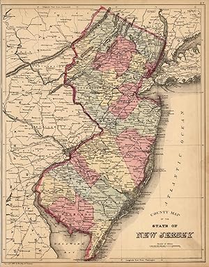
County Map of the State of New Jersey
Mitchell
Verkäufer
Art Source International Inc., Boulder, CO, USA
Verkäuferbewertung 2 von 5 Sternen
![]()
AbeBooks-Verkäufer seit 13. Juli 2001
Beschreibung
Beschreibung:
This map was made by S. Augustus Mitchell for "Mitchells New General Atlas" published in 1885, by WM. M. Bradley & Co. The well maintained maps in this atlas feature Mitchell's characteristic pastel coloring and abundant details of geographical features. The state of New Jersey is illustrated. Details include the names of counties, cities, towns, rail roads, mountain ranges, creeks, and rivers. Counties are differentiated by coloring. These 1885 maps offer a fascinating perspective of areas that have since undergone significant growth and change, in addition to their value as great examples of Mitchell's work.The size of the map is 11 x 14. Bestandsnummer des Verkäufers 67212
Bibliografische Details
Titel: County Map of the State of New Jersey
Erscheinungsdatum: 1885
Beste Suchergebnisse bei AbeBooks
County Map of the State of New Jersey
Anbieter: Art Source International Inc., Boulder, CO, USA
This map was made by S. Augustus Mitchell for "Mitchells New General Atlas" published in 1887. The well maintained maps in this atlas feature Mitchell's characteristic pastel coloring and abundant details of geographical features. New Jersey is illustrated on this map. Details include the names of counties, important towns, rivers, lakes and railroads. Counties are distinguished by color. These 1887 maps offer a fascinating perspective of areas that have since undergone significant growth and change, in addition to their value as great examples of Mitchell's work. This map measures 11.5 by 14.5 inches. Bestandsnummer des Verkäufers 23107
Anzahl: 1 verfügbar
County Map of the State of New Jersey
Anbieter: Art Source International Inc., Boulder, CO, USA
This map of New Jersey was made by S. Augustus Mitchell for "Mitchells New General Atlas" published in 1888, by WM. M. Bradley & Co. The well maintained maps in this atlas feature Mitchell's characteristic pastel coloring and abundant details of geographical features. Details include the names of counties, cities, towns, transportation routes, rivers and lakes. These 1888 maps offer a fascinating perspective of areas that have since undergone significant growth and change, in addition to their value as great examples of Mitchell's work. This map measures 11.5 by 14.5 inches. Bestandsnummer des Verkäufers 19045
Anzahl: 2 verfügbar
County Map of the State of New Jersey
Anbieter: Art Source International Inc., Boulder, CO, USA
This map was made by S. Augustus Mitchell for "Mitchells New General Atlas" published in 1884, by WM. M. Bradley & Co. The well maintained maps in this atlas feature Mitchell's characteristic pastel coloring and abundant geographical features. Details include the names of counties, cities, towns, transportation routes, rivers, lakes, and mountain ranges. Regions are distinguished by color. These 1884 maps offer a fascinating perspective of areas that have since undergone significant growth and change, in addition to their value as great examples of Mitchell's work. This map measures 11.5 by 14 inches. Bestandsnummer des Verkäufers 28920
Anzahl: 1 verfügbar
County Map of the State of New Jersey [verso with] County Map of Pennsylvania [adjacent with] Harrisburg [and] Williamsport [and] Erie [and] Scranton
Anbieter: Kaaterskill Books, ABAA/ILAB, East Jewett, NY, USA
Hand colored map. Plate 37: County Map of the State of New Jersey. Copyright 1882 by Bradley & Company. 11.5 x 14.5 inches. [On verso] Plate 38: County map of Pennsylvania. Copyright 1882, by Bradley & Company. 22 x 14.5 inches. [On adjacent] Plate 39: Maps of Harrisburg; Williamsport; Erie; and Scranton. 1884. 18.25 x 14.5 inches. From: Mitchell's New General Atlas, Containing Maps Of The Various Countries Of The World, Plans Of Cities, Etc., Embraced In Ninety-Three Quarto Maps, Forming A Series Of One Hundred and Forty-seven Maps and Plans, Together With Valuable Statistical Tables. Also, A List Of Post-Offices Of The United States And Territories, And Also Census Of 1880 For States, Territories And Counties, Also Of Cities Of Over 10,000 Inhabitants. Philadelphia: Published By Wm. M. Bradley & Bro., No. 1026 Arch Street. 1886. Very good, faint toning, small tear to lower margin. Bestandsnummer des Verkäufers 45709
Anzahl: 1 verfügbar
County Map of the State of Pennsylvania, New Jersey, Maryland, and Delaware
Anbieter: Nicholas D. Riccio Rare Books, ABAA, Florham Park, NJ, USA
Unbound, colored engraved map, decorative boarder, 14"x 11". Slight toning and aging; overall very bright and clear and in very good shape. Maps are wrapped with acid free board, or in rigid sleeves. The Mitchell family started to produce atlases in 1846, and continued into the early 1890s. Around 1860, S. Augustus Mitchell Jr. took over, and the atlas would be called Mitchell's New General Atlas. This is a colorful map of Pennsylvania, but includes New Jersey, Maryland and Delaware, from the 1865 installment of that atlas. The map is bright and crisp, and includes inset maps of Philadelphia and Baltimore. Ristow 311-313. Bestandsnummer des Verkäufers 101132
Anzahl: 1 verfügbar
County Map of the State of New Jersey
Anbieter: Nicholas D. Riccio Rare Books, ABAA, Florham Park, NJ, USA
Unbound, colored engraved map, 15"x 11 1/2". Some toning and aging; otherwise bright and clear. Maps are wrapped with acid free board, or in rigid sleeves. The Mitchell family started to produce atlases in 1846, and continued into the early 1890s. Around 1860, S. Augustus Mitchell Jr. took over, and the atlas would be called Mitchell's New General Atlas. This is a colorful and attractive map of New Jersey from the 1882 installment of that atlas. On the reverse of this map, is a double page map of Pennsylvania. Ristow 311-313 Phillips 907. Bestandsnummer des Verkäufers 101051
Anzahl: 1 verfügbar


