Beschreibung
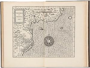
"Small folio (11 3/4 x 7 1/2 in. 30 x 19.2 cm). Engraved title within an elaborate architectural frame surmounted by the Habsburg imperial coat of arms, privileges dated 15 May 1597 and 17 July 1596, 19 copper-engraved double page maps interleaved in text, text mispaginated as usual but complete with final blank. BINDING/CONDITION: Full brown morocco by Alix, the spine in six compartments with raised bands (the second and last lettered gilt), marbled endpapers, edges gilt. Quarter brown morocco folding case, two green morocco labels on spine, one on front of case; a few nicks. (64V1G) A FINE, BRIGHT COPY. THE RARE FIRST EDITION, FIRST ISSUE. A SUPERB COPY OF THE FIRST ATLAS SPECIFICALLY DEVOTED TO THE AMERICAS. "As the first general geography of America, the text of Wytfliet's work may, at least in some degree, have contributed to dispel many of the errors regarding the New World … In the history of early cartography, the maps in Wytfliet's Augmentum play the same part for the New World as Ptolemy's do for the old hemisphere, and they give us.a valuable summary of the early cartography of America" (Nordenskiöld. Facsimile-Atlas to the History of Cartography). CONTAINING SOME OF THE EARLIEST REGIONAL MAPS OF NORTH AMERICA. Intended to supplement Ptolemy's Geographia, Wytfliet describes those parts of the world revealed by modern discovery that were unknown to the Alexandrian geographer. Wytfliet edited his text using printed editions of primary sources accounts of the early exploration period such as the works of Acosta, Hakluyt, de Bry and Ramusio. He supplements his text with a fine double-hemispherical world map based on Rumold Mercator's 1587 map (Shirley 207) and eighteen regional representations of the Americas: eight maps of North America (Burden 100-107), ten maps of South America (Chile, Peru, two maps of Brazil, present-day Colombia and Venezuela, the northernmost coast of South America with the neighboring Caribbean islands, Hispaniola, Cuba, and Jamaica, and two maps of Central America). Significant among the North American maps are New England and Virginia, New France and Canada, Florida and Apalche, New Granada and California, and Quivira and Anian. "Norvmbega et Virginia" is the most accurate depiction of the east coast from the Carolinas to Canada until Joannes de Laet's 1630 "Nova Anglia, Novvm Belgivm, et Virginia" and the second map to use the name Virginia. "Nova Francia et Canada" is the first to use "Canada" in its title and the first to focus on the river and the Gulf of St. Lawrence. It summarizes sixteenth-century knowledge of the region just prior to major French expansion there and the voyages of Samuel de Champlain (Burden 102). "Granata Nova et California" is the first printed map specifically devoted to California and the southwest of the present-day United States. One of its interesting features is its depiction of a number of fabled places, largely derived from Spanish sources. "Limes Occidentis | Quiuira et Anian" encompasses the western coastal portions of the present-day United States and Canada. Based on Gerard Mercator's world map (1569), its bulging shape is remarkably similar to that of Alaska as it is known today (Burden 107).". Bestandsnummer des Verkäufers 65ERM0024
Verkäufer kontaktieren
Diesen Artikel melden
![]()

