Beschreibung
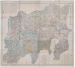
Large folding handcoloured map of the thirteen provinces from which Mt. Fuji can be viewed. 159 x 178cm. Folds into paper covered card covers measuring 40 x 24cm. Title label upper cover. A little browning along folds, occasional spotting and soiling. A little worming causing approximately 1cm of loss in places. Two chops in lower section. A very striking and attractive map. This very large handsome map is a detailed map of the thirteen provinces from which one can see Mt. Fuji. Provinces shown are the eight provinces of the Kant? region, Sagami ??, Musashi ??, Kazusa ??, Shimofusa ??, Awa ??, K?zuke ??, Shimotsuke ??, and Hitachi, ??, and five other provinces, Izu ??, Suruga ??, T?t?mi ??, Kai ??, and Shinano ?? The map offers a large amount of detailed information such as province and county borders, rivers, high ways, post towns, checkpoints, villages, and scenic spots. The cartographer, Akiyama Einen [or Nagatoshi] ???? came from Edo and the editor Funakoshi Seiz? ???? [studio name: Shugu ??] [1805-62], a Confucian scholar, from Nagato Province (now the western half of present-day Yamaguchi Prefecture). A dedication by Funahashi Akira[?] ??? is dated 1843. Bestandsnummer des Verkäufers 159850
Verkäufer kontaktieren
Diesen Artikel melden
![]()

