
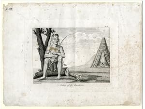
INDIAN OF THE MANDANES [caption title]
[Collot, Georges Henri Victor]
Verlag: [Paris, 1826
Gebraucht
Verkäufer
William Reese Company - Americana, New Haven, CT, USA
Verkäuferbewertung 4 von 5 Sternen
![]()
AbeBooks-Verkäufer seit 13. Juli 2006
Dieses Exemplar ist nicht mehr verfügbar. Hier sind die ähnlichsten Treffer für INDIAN OF THE MANDANES [caption title] von [Collot, Georges Henri Victor].
Beschreibung
Beschreibung:
Line engraving, approximately 10 1/4 x 14 inches. Matted. A few small chips and very short closed tears at edges. Small numbered label at lower left corner, later pencil annotations on blank verso. Light dampstaining and foxing. Good plus. From the atlas of Collot's famous VOYAGE DANS L'AMÉRIQUE SEPTENTRIONALE., plate twenty- four, depicting a member of the Mandan tribe. Collot was sent by the French government to survey the Ohio and Mississippi valleys in 1796, to gauge the military situation on the frontier on the Spanish and American sides of the river, and to determine possible secessionist sentiment among American frontiersmen. Despite numerous difficulties in operating as a secret agent, under suspicion by both American and Spanish officials, Collot gathered a wealth of cartographical material, as well as sounding political waters. Returning to France, he prepared his work for publication and had it printed in 1804. Unfortunately, Napoleon had just sold Louisiana and, not wishing to draw attention to the area of which he had disposed, suppressed the publication. Collot died in 1805, and the sheets of the book and atlas sat in a warehouse for the next two decades. They were then purchased by Arthus Bertrand, the leading French publisher of voyages at the time. According to Bertrand's own testimony, he retained the original maps and plans, issued new titlepages with his imprint, and destroyed a number of sets to make it more scarce. The views in the atlas, printed on heavy paper, are quite impressive, and are some of the earliest of scenes in the Mississippi Valley. Bestandsnummer des Verkäufers WRCAM52522
Bibliografische Details
Titel: INDIAN OF THE MANDANES [caption title]
Verlag: [Paris
Erscheinungsdatum: 1826
Beste Suchergebnisse bei AbeBooks

Foto des Verkäufers
INDIAN OF THE MANDANES [caption title].
Verlag:
[Paris. 1826 (i.e., 1804)]., 1826
Gebraucht
Anbieter: William Reese Company - Americana, New Haven, CT, USA
Verkäuferbewertung 4 von 5 Sternen
![]()
From the atlas of Collot's famous VOYAGE DANS L'AMÉRIQUE SEPTENTRIONALE., plate twenty-four, depicting a member of the Mandan tribe. Collot was sent by the French government to survey the Ohio and Mississippi valleys in 1796, to gauge the military situation on the frontier on the Spanish and American sides of the river, and to determine possible secessionist sentiment among American frontiersmen. Despite numerous difficulties in operating as a secret agent, under suspicion by both American and Spanish officials, Collot gathered a wealth of cartographical material, as well as sounding political waters. Returning to France, he prepared his work for publication and had it printed in 1804. Unfortunately, Napoleon had just sold Louisiana and, not wishing to draw attention to the area of which he had disposed, suppressed the publication. Collot died in 1805, and the sheets of the book and atlas sat in a warehouse for the next two decades. They were then purchased by Arthus Bertrand, the leading French publisher of voyages at the time. According to Bertrand's own testimony, he retained the original maps and plans, issued new titlepages with his imprint, and destroyed a number of sets to make it more scarce. The views in the atlas, printed on heavy paper, are quite impressive, and are some of the earliest of scenes in the Mississippi Valley. Line engraving, approximately 10Ľ x 14 inches. Matted. A few small chips and very short closed tears at edges. Small numbered label at lower left corner, later pencil annotations on blank verso. Light dampstaining and foxing. Good plus. Bestandsnummer des Verkäufers 52522
Anzahl: 1 verfügbar