
MAP OF ABILENE.PUBLISHED BY LOUIS C. WISE & Co.GENERAL AGENTS FOR LANDS IN NORTHWEST TEXAS. CONTROL OVER 500 LOTS IN ALL PARTS OF ABILENE. CHOICE LANDS NEAR TOWN
[Texas]: Kirby, A.H.
Verlag: Louis C. Wise & Co. (but lithographed by Clarke and Courts, Galveston), Abilene, Tx., 1885
Gebraucht
Verk�ufer
William Reese Company - Americana, New Haven, CT, USA
Verk�uferbewertung 4 von 5 Sternen
![]()
AbeBooks-Verk�ufer seit 13. Juli 2006
Dieses Exemplar ist nicht mehr verf�gbar. Hier sind die �hnlichsten Treffer f�r MAP OF ABILENE.PUBLISHED BY LOUIS C. WISE & Co.GENERAL AGENTS FOR LANDS IN NORTHWEST TEXAS. CONTROL OVER 500 LOTS IN ALL PARTS OF ABILENE. CHOICE LANDS NEAR TOWN von [Texas]: Kirby, A.H..
Beschreibung
Beschreibung:
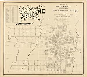
Lithographed map, 27 x 24 inches. Minor edge wear, some soft creases. Very good. A rare map of Abilene, Texas, quite likely the earliest large map of the city. Abilene, some 180 miles west of Dallas, was established in 1881 by cattlemen as a stock shipping point on the Texas & Pacific Railroad, and it was promoted as the future great city of west Texas. By 1883 it became the seat of Taylor County, replacing Buffalo Gap, which had been passed over by the railroad. This map, which is undated but likely produced circa 1885, shows the rapid growth of the city. The map was drawn by A.H. Kirby and compiled by Kirby and County Surveyor J.A. Thomas. It is highly detailed, showing hundreds of lots available in the city from Louis C. Wise & Company (successor to Holt & Wise), the largest land agent in Abilene. A table provides the names of several land owners, with numbers corresponding to lots and blocks on the map. The map also gives street names, the route of the Texas & Pacific Railroad, the location of the stock pens near the train depot, and the paths of three creeks. Louis Wise was one of the earliest residents of Abilene. He graduated from the Virginia Military Institute in 1864 and following the Civil War went to Mexico as an engineer on the survey of the Vera Cruz and Mexico Railroad. Wise came to Texas in 1866, was employed as a draftsman in the state land office in Austin, and settled in Abilene when the town was founded. This map was printed by the Galveston firm of Clarke & Courts, which was among the earliest successful lithographic firms in Texas. OCLC locates five copies, at Yale (two copies), Southern Methodist University, the Library of Congress, and the University of Texas at Arlington. OCLC 78372731, 81463312. Bestandsnummer des Verk�ufers WRCAM52697
Bibliografische Details
Titel: MAP OF ABILENE.PUBLISHED BY LOUIS C. WISE & ...
Verlag: Louis C. Wise & Co. (but lithographed by Clarke and Courts, Galveston), Abilene, Tx.
Erscheinungsdatum: 1885
Beste Suchergebnisse bei AbeBooks

Foto des Verk�ufers
MAP OF ABILENE.PUBLISHED BY LOUIS C. WISE & Co.GENERAL AGENTS FOR LANDS IN NORTHWEST TEXAS. CONTROL OVER 500 LOTS IN ALL PARTS OF ABILENE. CHOICE LANDS NEAR TOWN.
Verlag:
Abilene, Tx.: Louis C. Wise & Co. (but lithographed by Clarke and Courts, Galveston), [ca. 1885]., 1885
Gebraucht
Anbieter: William Reese Company - Americana, New Haven, CT, USA
Verk�uferbewertung 4 von 5 Sternen
![]()
Lithographed map, 27 x 24 inches. Minor edge wear, some soft creases. Very good. A rare map of Abilene, Texas, quite likely the earliest large map of the city. Abilene, some 180 miles west of Dallas, was established in 1881 by cattlemen as a stock shipping point on the Texas & Pacific Railroad, and it was promoted as the future great city of west Texas. By 1883 it became the seat of Taylor County, replacing Buffalo Gap, which had been passed over by the railroad. This map, which is undated but likely produced circa 1885, shows the rapid growth of the city. The map was drawn by A.H. Kirby and compiled by Kirby and County Surveyor J.A. Thomas. It is highly detailed, showing hundreds of lots available in the city from Louis C. Wise & Company (successor to Holt & Wise), the largest land agent in Abilene. A table provides the names of several land owners, with numbers corresponding to lots and blocks on the map. The map also gives street names, the route of the Texas & Pacific Railroad, the location of the stock pens near the train depot, and the paths of three creeks. Louis Wise was one of the earliest residents of Abilene. He graduated from the Virginia Military Institute in 1864 and following the Civil War went to Mexico as an engineer on the survey of the Vera Cruz and Mexico Railroad. Wise came to Texas in 1866, was employed as a draftsman in the state land office in Austin, and settled in Abilene when the town was founded. This map was printed by the Galveston firm of Clarke & Courts, which was among the earliest successful lithographic firms in Texas. OCLC locates five copies, at Yale (two copies), Southern Methodist University, the Library of Congress, and the University of Texas at Arlington. OCLC 78372731, 81463312. Bestandsnummer des Verk�ufers 52697
Anzahl: 1 verf�gbar