Beschreibung
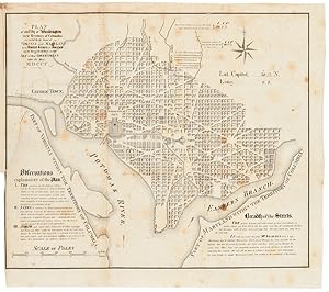
159 leaves printed on recto only, plus three folding maps. Lacks the titlepage. Folio. Contemporary three-quarter calf and marbled boards, rebacked with original gilt backstrip laid down. Binding rubbed and worn. Old stain throughout. Folding maps with tears repaired on versos, with no loss. One plat map leaf (number 24) torn with a small amount of loss; a closed tear in another leaf with no loss. An occasional light fox mark. Good. Lacks the titlepage. A remarkable cartographic study of Washington, D.C. in the decade before the Civil War. The folding maps show, respectively, the "Territory of Columbia"; "Plan of the City of Washington in the Territory of Columbia.," a very detailed rendering of the streets and blocks designated by number, with "Observations explanatory of the Plan" and a long note regarding the "Breadth of the Streets"; and a larger, even more detailed map of the city with a list of special attractions referenced on the map. This map was engraved by W.J. Stone, and is based on Andrew Ellicott's earlier map of the District. The 159 numbered leaves of the book, printed on the rectos only and interleaved with blank leaves, correspond to the number squares on this large "key" map. The plat maps show "zoom views" of the various blocks, and the division of lots within them, each leaf generally illustrating four to six "squares." Laid into this copy is a later street directory of Washington, extracted from another work. A handsome plat atlas of Washington, D.C. PHILLIPS, ATLASES, p.266. Bestandsnummer des Verkäufers WRCAM39573
Verkäufer kontaktieren
Diesen Artikel melden
![]()


