
MILITARY MAP OF SOUTH-EASTERN VIRGINIA
Lindenkohl, Adolph
Verlag: Henry Lindenkohl & Charles G. Krebs, Washington, 1864
Gebraucht
Verk�ufer
William Reese Company - Americana, New Haven, CT, USA
Verk�uferbewertung 4 von 5 Sternen
![]()
AbeBooks-Verk�ufer seit 13. Juli 2006
Dieses Exemplar ist nicht mehr verf�gbar. Hier sind die �hnlichsten Treffer f�r MILITARY MAP OF SOUTH-EASTERN VIRGINIA von Lindenkohl, Adolph.
Beschreibung
Beschreibung:
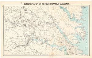
19 x 30 1/2 inches. Printed in blue and black. Matted. Minor foxing and soiling. Very good. An important military map showing the area around Richmond and Petersburg, Virginia, all the way to the Chesapeake Bay, and including the Northern Neck and the country as far south as Norfolk. Railroads, roads, and waterways are all noted in detail. Richmond has been ringed with concentric circles, printed in blue, spaced five miles apart to show the distance from the city. This map was compiled by the U.S. Coast Survey and is dated June 1864. With the beginning of the Civil War the United States Army found itself scrambling to obtain adequate field maps for military operations in the South. The most established cartographic branch of the government, the Coast Survey, was pressed into service to provide these maps, some with a coastal component, but mainly for landlocked locations. The cartographers of the Coast Survey reviewed all of the existing cartography available as well as drawing on military and scouting reports and covert agents to assemble the most detailed possible maps showing places, roads, railroads, and natural features. Two key figures in the Coast Survey effort during the War were Henry Lindenkohl and his brother, Adolph, who were responsible for actually drawing many of the field maps. The Lindenkohls were born in Germany but emigrated to the United States as teenagers and became American citizens. Adolph had already worked at the Coast Survey before the war began, and Henry joined in 1861. Together they made a huge contribution to the war effort through their superb cartographic work, producing and revising maps of different theatres of operations through 1865. Both continued with the survey for the rest of their lives. Adolph died in 1904 after fifty years on the job, and Henry in 1920 after fifty-nine. By the time this map was executed, Grant had pushed southward in the bitter fighting of the summer of 1864, and the noose had tightened around Richmond and Petersburg. LC, MAPS OF THE CIVIL WAR 490. Bestandsnummer des Verk�ufers WRCAM46148
Bibliografische Details
Titel: MILITARY MAP OF SOUTH-EASTERN VIRGINIA
Verlag: Henry Lindenkohl & Charles G. Krebs, Washington
Erscheinungsdatum: 1864
Beste Suchergebnisse bei AbeBooks

Foto des Verk�ufers
MILITARY MAP OF SOUTH-EASTERN VIRGINIA.
Verlag:
Washington: Henry Lindenkohl & Charles G. Krebs, 1864., 1864
Gebraucht
Anbieter: William Reese Company - Americana, New Haven, CT, USA
Verk�uferbewertung 4 von 5 Sternen
![]()
An important military map showing the area around Richmond and Petersburg, Virginia, all the way to the Chesapeake Bay, and including the Northern Neck and the country as far south as Norfolk. Railroads, roads, and waterways are all noted in detail. Richmond has been ringed with concentric circles, printed in blue, spaced five miles apart to show the distance from the city. This map was compiled by the U.S. Coast Survey and is dated June 1864. With the beginning of the Civil War the United States Army found itself scrambling to obtain adequate field maps for military operations in the South. The most established cartographic branch of the government, the Coast Survey, was pressed into service to provide these maps, some with a coastal component, but mainly for landlocked locations. The cartographers of the Coast Survey reviewed all of the existing cartography available as well as drawing on military and scouting reports and covert agents to assemble the most detailed possible maps showing places, roads, railroads, and natural features. Two key figures in the Coast Survey effort during the War were Henry Lindenkohl and his brother, Adolph, who were responsible for actually drawing many of the field maps. The Lindenkohls were born in Germany but emigrated to the United States as teenagers and became American citizens. Adolph had already worked at the Coast Survey before the war began, and Henry joined in 1861. Together they made a huge contribution to the war effort through their superb cartographic work, producing and revising maps of different theatres of operations through 1865. Both continued with the survey for the rest of their lives. Adolph died in 1904 after fifty years on the job, and Henry in 1920 after fifty-nine. By the time this map was executed, Grant had pushed southward in the bitter fighting of the summer of 1864, and the noose had tightened around Richmond and Petersburg. LC, MAPS OF THE CIVIL WAR 490. 19 x 30� inches. Printed in blue and black. Matted. Minor foxing and soiling. Very good. Bestandsnummer des Verk�ufers 46148
Anzahl: 1 verf�gbar