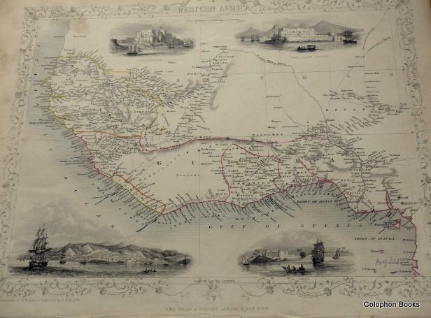
Map of Western Africa. With vignettes by H. Winkles and engraved by E. Radclyffe
John Tallis.
Verkäufer Colophon Books (UK), Leek, Vereinigtes Königreich
AbeBooks Verkäufer seit 2. Januar 2015
Alle Artikel dieses Verkäufers anzeigen
Anzahl: 1Verkäufer Colophon Books (UK), Leek, Vereinigtes Königreich
AbeBooks Verkäufer seit 2. Januar 2015
Alle Artikel dieses Verkäufers anzeigen
Anzahl: 1Beschreibung
Landscape map of Western Africa from the last great atlas of 1851 by John Tallis showing the African coast from The Gulf of Guinea and Bight of Biafra to the north of the River Senegal on the coastline, with 4 vignette engravings, outline colouring. Some handling with a smudge mark top edge within map area and edges thumbed also, mainly at edges and the odd tiny edge split, sold with the two page text of the produce and populations etc, etc of the regions covered. Measures: 26.5 x 36 cm approx. Good to Very good. (Would frame beautifully). Bestandsnummer des Verkäufers 3146
Bibliografische Details
Titel: Map of Western Africa. With vignettes by H. ...
Verlag: John Tallis & Company., London.
Erscheinungsdatum: 1851
Einband: No Binding
Illustrator: J. Rapkin.
Zustand: Good
Auflage: 1st Edition
Anbieterinformationen
We guarantee the condition of every book as it's described on the AbeBooks web sites. If you're dissatisfied with your purchase (Incorrect Book/Not as Described/Damaged) or if the order hasn't arrived, you're eligible for a refund within 30 days of the estimated delivery date. If you've changed your mind about a book that you've ordered, please use the Ask bookseller a question link to contact us and we'll respond within 2 business days. This does not affect your statutory consumer rights includ...
Mehr InformationShipping costs are based on books weighing 2.2 LB, or 1 KG. If your book order is heavy or oversized, we may contact you to let you know extra shipping is required.
Zahlungsarten
akzeptiert von diesem Verkäufer
Bankeinzug Vorauskasse Bar Banküberweisung