Beschreibung
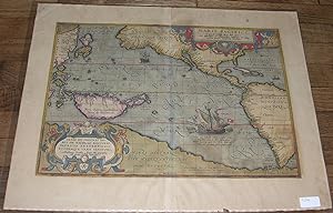
"Single sheet, (17 ¾ x 23 ½ inches). EXCEPTIONALLY FINE engraved map of the Pacific Ocean, the title in an elaborate mannerist strapwork and allegorical cartouche upper right and the imprint in the lower left, the ocean decorated with ships all with hand-color in full (evenly browned, two older tape repairs to verso, one or two pale stains). THE FIRST PRINTED MAP TO BE DEVOTED TO THE PACIFIC OCEAN AND TO SHOW AN EARLY DEPICTION OF THE WEST COAST OF AMERICA. 1603 Latin edition, first published in 1570. Van den Broecke estimates this edition to have been printed in a run of 300 copies only. This map, from the 1603 Antwerp edition with text in Latin on the verso, was one of the most important that appeared in Abraham Ortelius's "Theatrum orbis terrarium." Entitled "Maris Pacifici" - "Ocean of Tranquility" - it was the first printed map to be devoted to the Pacific Ocean, and also includes an early depiction of the west coast of North America, Japan and New Guinea. Nova Hispania (Mexico) and the California peninsula are shown quite accurately for the time. Primarily, however, the map celebrates the achievements of Magellan, the first to traverse the Pacific Ocean and to discover the strait at the southern tip of South America that would come to be named in his honor. Magellan's ship "Victoria" is depicted in the Pacific along with a celebratory Latin inscription. The map is unusually centered on the Pacific itself rather than on any landmass, thus showing the ocean in its entirety as it stretches from Asia to America. This deceptively simple compositional strategy emphasizes the vastness of the Pacific while stressing the magnitude of Magellan's achievement as the first to circumnavigate the globe. Ortelius derived much of the Pacific cartography from the map published in 1589 by his associate, the map engraver Frans Hogenberg, though Ortelius introduced a considerably narrower and more correct North America at the latitude of the Tropic of Cancer than Hogenberg. Although the plate bears the date of 1589, "Maris Pacifici" was first published in Ortelius's 1590 "Additamentum," an appendix to his atlas, and was then included in future editions of the "Theatrum." Ortelius "was very bold to attempt to map what was perhaps the least-known part of the world. He must have realized, however, that the Pacific was increasing in stature as a commercial route to Asia. The long-hoped-for northwest passage had not been found, and mariners avoided the Portuguese-controlled South African voyage to Asia. The ocean became the focus of much sixteenth century exploration. "The symbol of that exploration was Ferdinand Magellan's ship Victoria; on the map it is at sea, having just passed through the strait that bears his name. Magellan became the first European mariner to sail from the Atlantic Ocean to the Pacific, and his voyage revealed much about the Pacific Ocean…more was known about the west coast of America and the Pacific after Sir Francis Drake's circumnavigation (1577-1580), when he explored America's west coast and named it New Albion. Ortelius followed Drake's voyage with keen interest, corresponded with Gerard Mercator about it, and incorporated as much as he could from Drake's discoveries onto 'Maris Pacifici' - the Gulf of California takes on an entirely new shape and the Rio Grande is introduced for the first time on a printed map… "Along the lower part of the map is 'Terra Australia,' not an early form of Australia, but a large phantom continent that the early mapmakers believed balanced the weight of Europe and Asia. When Magellan sailed around South America, he believed he was following the coastline of the northern tip of Terra Australis. Like other sixteenth-century map-makers, Ortelius incorporated this enormous continent into his map of the Pacific Ocean" (Cohen). Van den Broecke Ort12.". Bestandsnummer des Verkäufers 72MMS219
Verkäufer kontaktieren
Diesen Artikel melden
![]()
