


NOUVEAUX VOYAGES DE MR. LE BARON DE LAHONTAN, DANS L'AMERIQUE SEPTENTRIONALE. [with:] MEMOIRES DE L'AMERIQUE SEPTENTRIONALE, OU LA SUITE DES VOYAGES.
Lahontan, Louis Armand, Baron de
Verlag: Chez les Freres l'Honore, The Hague, 1703
Gebraucht
Verk�ufer
William Reese Company - Americana, New Haven, CT, USA
Verk�uferbewertung 4 von 5 Sternen
![]()
AbeBooks-Verk�ufer seit 13. Juli 2006
Dieses Exemplar ist nicht mehr verf�gbar. Hier sind die �hnlichsten Treffer f�r NOUVEAUX VOYAGES DE MR. LE BARON DE LAHONTAN, DANS L'AMERIQUE SEPTENTRIONALE. [with:] MEMOIRES DE L'AMERIQUE SEPTENTRIONALE, OU LA SUITE DES VOYAGES. von Lahontan, Louis Armand, Baron de.
Beschreibung
Beschreibung:
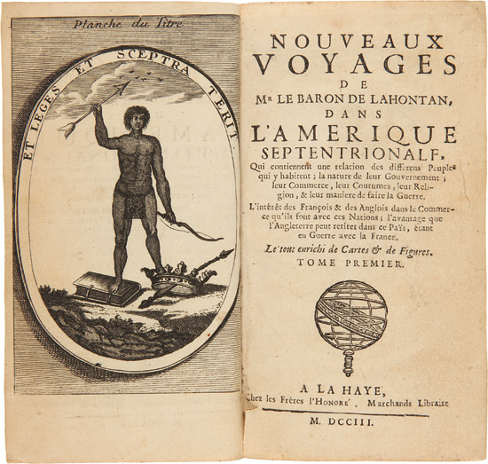
Two volumes. [24],279pp. plus frontispiece, two folding maps, and eleven plates (two folding); 220,[17]pp. plus folding map and eleven plates (three folding). 12mo. Later 19th-century half calf and marbled boards, spines gilt. Extremities rubbed. Large folding map reinforced at folds. Some light toning and soiling. About very good. First edition, third issue with the titlepages all in black and the globe vignette, with the maps re-engraved and improved. This is cartographically the best edition. Lahontan's narrative is a curious blending of fact and fantasy. His account of his travels in the Great Lakes region is one of the most important travel narratives of the day, but his claims to having travelled west of the Mississippi are highly doubtful; however, his assertions had great impact on geographers of the time, who adopted much of his imaginary geography. The most notable map in the book is the "Carte de la Riviere Longue," depicting an imaginary river extending westward from Lake Superior, a concept which confused generations of cartographers. The "Carte General de Canada" is also considerably confused geographically. Whatever his shortcomings as an explorer, Lahontan was one of the most perceptive observers of American Indian life at the time, and this work is a major source for the Huron and other tribes on the Great Lakes. It remains a classic voyage by a man "of more than ordinary learning and intelligence" (Sabin). HOWES L25, "b." CLARK I:111. PILLING, ALGONQUIAN 291. MICHIGAN RARITIES 6. WHEAT TRANSMISSISSIPPI 86. SABIN 38635, 38636. GREENLY, MICHIGAN 9 (ref). EUROPEAN AMERICANA 703/90. LANDE 497. Bestandsnummer des Verk�ufers WRCAM47241
Bibliografische Details
Titel: NOUVEAUX VOYAGES DE MR. LE BARON DE LAHONTAN...
Verlag: Chez les Freres l'Honore, The Hague
Erscheinungsdatum: 1703
Beste Suchergebnisse bei AbeBooks

NOUVEAUX VOYAGES DE MR. LE BARON DE LAHONTAN, DANS L'AMERIQUE SEPTENTRIONALE. [with:] MEMOIRES DE L'AMERIQUE SEPTENTRIONALE, OU LA SUITE DES VOYAGES.
Verlag:
The Hague: Chez les Freres l'Honore, 1703., 1703
Gebraucht
Anbieter: William Reese Company - Americana, New Haven, CT, USA
Verk�uferbewertung 4 von 5 Sternen
![]()
First edition, third issue with the titlepages all in black and the globe vignette, with the maps re-engraved and improved. This is cartographically the best edition. Lahontan's narrative is a curious blending of fact and fantasy. His account of his travels in the Great Lakes region is one of the most important travel narratives of the day, but his claims to having travelled west of the Mississippi are highly doubtful; however, his assertions had great impact on geographers of the time, who adopted much of his imaginary geography. The most notable map in the book is the "Carte de la Riviere Longue," depicting an imaginary river extending westward from Lake Superior, a concept which confused generations of cartographers. The "Carte General de Canada" is also considerably confused geographically. The second volume also contains the "Dictionaire de la Langue des Sauvages." The work remains a classic voyage, even if partially imaginary, and is is a major source for the Huron and other tribes on the Great Lakes, written by a man "of more than ordinary learning and intelligence" (Sabin). "Although much of the work has been condemned as over-imaginative, it did influence the subsequent growth of primitivism in France and England, as reflected in the works of Montesquieu, Voltaire, Jonathan Swift, and others. For example, he tells of a tribe which he calls Essanapes, who worshiped the sun, the moon, and the stars. Beyond the Essanapes lived the Gnascitares, who lived on the shore of a great lake, and upon this lake were canoes rowed by 200 oarsmen. They had buildings three storeys high and fought battles with the Spaniards in New Mexico. The great king of this country lived in a royal palace waited upon by hundreds of servants. To add weight to this account Lahontan actually drew a map of the region, now located within the boundaries of Nebraska and South Dakota" - Howgego. HOWES L25, "b." CLARK I:111. PILLING, ALGONQUIAN 291. MICHIGAN RARITIES 6. WHEAT TRANSMISSISSIPPI 86. SABIN 38635, 38636. GREENLY, MICHIGAN 9 (ref). EUROPEAN AMERICANA 703/90. LANDE 497. Two volumes. [24],279pp. plus frontispiece, two folding maps, and eleven plates (two folding); 220,[17]pp. plus folding map and eleven plates (three folding). 12mo. Later 19th-century half calf and marbled boards, spines gilt. Extremities rubbed. Large folding map reinforced at folds. Some light toning and soiling. About very good. Bestandsnummer des Verk�ufers 47241
Anzahl: 1 verf�gbar