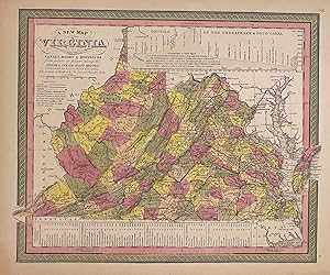
A New Map of Virginia with its Canals, Roads, & Distances
MITCHELL, Samuel Augustus Jr.
Verkäufer
Argosy Book Store, ABAA, ILAB, New York, NY, USA
Verkäuferbewertung 4 von 5 Sternen
![]()
Heritage Bookseller
AbeBooks-Mitglied seit 1996
Beschreibung
Beschreibung:
Map. Engraving with original hand coloring. Image measures 11 1/2" x 14 1/4" Nicely detailed map of Virginia and West Virginia divided into counties. Shows towns, waterways, major routes, railroads and topographical details. An inset at the top depicts a profile view of the Chesapeake and Ohio Canal. A table at the bottom provides information on steamboat routes. Samuel Augustus Mitchell Sr. (1792-1868) was one of the leaders in American cartography of the 19th century and pioneered the conversion of engraved map plates to more affordable lithographic plates. His son, Samuel Augustus Mitchell Jr. continued his father's successful mapmaking and publishing business, and was one of the most prolific and renowned 19th century American publishers. Bestandsnummer des Verkäufers 307829
Bibliografische Details
Titel: A New Map of Virginia with its Canals, Roads...
Verlag: Mitchell, Samuel Augustus Jr., Philadelphia
Erscheinungsdatum: 1864
Einband: unbound
Beste Suchergebnisse bei AbeBooks
A New Map of Virginia, with its Canals, Roads & Distances .
Anbieter: High Ridge Books, Inc. - ABAA, South Deerfield, MA, USA
Fully colored map of Virginia from Mitchell's 1850 New Universal Atlas (No. 17). Wide margins. Full color by county. Profile of the Chesapeake & Ohio Canal at the top right. Table of steamboat routes at bottom. Railroads are highlighted in red, canals in blue. Bestandsnummer des Verkäufers m02037
Anzahl: 1 verfügbar
A New Map of Virginia with its Canals, Roads & Distances from place to place alon the Stage & Steam Boat Routes
Anbieter: Alexandre Antique Prints, Maps & Books, Toronto, ON, Kanada
Zustand: Very good. Size : 270x340 (mm), 10.625x13.375 (Inches), Hand Colored. Bestandsnummer des Verkäufers M5907
Anzahl: 1 verfügbar


