Beschreibung
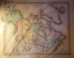
Original hand-colored, engraved map showing Canada, the upper portion of the U.S., Greenland, Iceland, and part of Asia. Map has beautifully-rendered pink, yellow, and blue watercoloring to illustrate which territories were claimed by Britain, Denmark, and Russia, respectively. Map with margins measures 18 3/8" x 15 1/2"; actual map area measures 11 1/4" x 14 1/4." Clean and intact map with very little foxing mostly limited to the margins. Beautiful black and white decorative scrollwork border around the map, which is commonly found on Colton maps. Title at the top. "No. 3" printed in lower-right corner. The one leaf of text measures 15 1/2" x 18 3/8" and includes descriptions of Russian, Danish, and British North America (text continues onto another page that is not included). This map and accompanying page of text originally appeared in Colton's Atlas of the World, Illustrating Physical and Political Geography by George W. Colton; Accompanied by Descriptions Geographical, Statistical, and Historical by Richard Swainson Fisher; Volume I--North and South America, Etc. (1857). While this map comes from the 1857 edition, the 1856 first edition was G. W. Colton's first atlas published and one of the most accurate of its time. Joseph H. Colton (1800-1893) founded J. H. Colton and Company which was a leading mapmaking company in the international cartography industry. Joseph Colton employed some of the preeminent cartographers and map engravers of the time. His sons, George W. Colton (1827-1901) and Charles B. Colton (1832-1916) later joined the company. Bestandsnummer des Verkäufers 019200
Verkäufer kontaktieren
Diesen Artikel melden
![]()
