Beschreibung
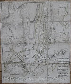
A Plan of New York Island, with part of Long Island, Staten Island & East New Jersey, with a particular description of the engagement on the Woody Heights of Long Island, between Flatbush and Brooklyn, on the 27th. of August 1776 between His Majesty's forces commanded by General Howe and the Americans under Major General Putnam, with the subsequent disposition of both armies. Folding engraved map (21 x 17 2/8 inches; 18 6/8 x 16 6/8 inches to the neat line), laid down on cartographic linen in 12 sections. Fine engraved battle plan of New York and environs, the title and imprint below the neat line, showing New York from Staten Island in the south to Tetard's Hill in the north, with original colour wash in outline, "References to the Battle of Long Island" lower right, and troop deployments shown in contemporary red (the British) and green (the Americans) colour wash. Provenance: with "Fort Jay" marked in manuscript on Governor's Island, first erected on the highest point of Governor's Island by Continental troops in 1775-1776. The island and its fort were occupied by the British during the American Revolution until 1783, when it was surrendered, along with several buildings, to the Governor of New York. First state (of 5 states), each subsequent state showing stages in the progress of the battle and updating features on the map. In this example the fourth line of the title reads "Disposition of both Armies", the sea coast, harbour and rivers are shown in single outline only, without any shading, the most northerly place marked on the Hudson River is 'Tetard's Hill", the Heights on Long Island are named twice as just "The Heights". The British troops are shown surrounding the Americans holding the Heights [of Guana] from the 22nd to the 26th of August, on the 3rd of September British Troops are at New Town. The British navy is shown in the Hudson River, and at Flushing in the East River. In anticipation of an attack by the British on New York George Washington, with five regiments of the army which had served him in New England, arrived there in early April of 1776. While the Continental Congress proclaimed the Declaration of Independence on July the 4th, Washington set about strengthening defenses, including building Fort Washington at the end of New York Island on the shore of the Hudson. With the reading of the new Declaration, on Washington's order, at the head of each brigade of the army in or near New York after it was adopted by the New York provincial congress on the 9th of July, and publically proclaimed from the City Hall in Wall Street on the 18th, New York came out firmly for the patriot cause. On the 27th of August the battle of Long Island occurred, "and as the British were greatly superior to their opponents in numbers, equipment, and training, they were everywhere victorious. By two o'clock in the afternoon they had taken the outer line of defense, and the Americans were driven within the fortified camp on Brooklyn Heights, where they were in grave danger of being captured" (Stokes, page 322). Being routed from Long Island, Washington crossed the river to Manhattan and held it, while he and Congress decided whether to burn the City behind them, or leave it to be occupied by the British troops over winter. All of this is clearly and faithfully recorded on Faden's map, and as such Faden's plan of the theatre of War in New York is one of the most important of the American Revolution. First published less than a month after the battle on October the 19th, 1776 the plan shows towns, settlements, roads, fortifications, and topographical features, as a background to the military positions and events in the early stages of the battle. Nebenzahl, Atlas of the American Revolution, 12; Nebenzahl, Printed Battle Plans 107; Tooley p. 75, Stevens-Tree 41a; Stokes Iconography 1:353-55; cf. NYPL/Deak 153-55. Bestandsnummer des Verkäufers 72map278
Verkäufer kontaktieren
Diesen Artikel melden
![]()
