Beschreibung
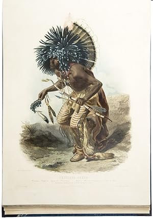
4 volumes (text: 2 volumes, large quarto [11 1/2 x 9 3/4 inches]; Tab. atlas of plates, oblong folio [17 x 23 3/4 inches]; Vig. atlas of plates, oblong small folio [11 1/2 x 17 inches]). Text: 12pp. subscribers' list [front of vol. II], 52 wood-engraved illustrations. Tab. atlas: 48 aquatint plates [17 hand-coloured], after Karl Bodmer, each plate with the Bodmer blind-stamp, engraved by J. Hurliman, L. Weber, C. Vogel, Salathé, Himely, Prévost, R. Rollet, P. Legrand, Desmadryl, and others, 1 large folding engraved map by Lieut.-Col.W. Thorn, titled "Map to illustrate the Route of Prince Maximilian of Wied," hand-coloured in outline. Vig. atlas: 33 aquatint plates [3 hand-coloured], after Karl Bodmer, heightened with gum arabic, each blindstamped "C. Bodmer / Direct," engraved by C. Vogel, L. Weber, J. Outhwaite, J. Hürlmann, Himely, Martens and others, 1 folding meteorological table. Extra-illustrated with the original lettered blue wrapper bound at the front of the large atlas. Expertly bound to style in half dark blue morocco over blue patterned paper covered boards, spine gilt, speckled edges This masterpiece is the pinnacle of illustrated works devoted to North America, and unquestionably the greatest of all illustrated books devoted to Indigenous Americans. Reise in Das Innere Nord-America is the finest work on Indigenous Americans and the American frontier and is the result of an epic journey which took place at a time when the mass migration of settlers and pioneers was about to irrevocably alter the unspoiled West. Karl Bodmer (1809-1893) was engaged by Prince Maximilian (already famed for his earlier explorations to Brazil) to provide a record of his travels among the Plains Indians of North America during 1833-1834. His efforts show great versatility and technical virtuosity and give us a uniquely accomplished and detailed picture of a previously little understood and soon to vanish way of life. The most important part of the travels of Prince Maximilian and Karl Bodmer started in St. Louis, whence they proceeded up the treacherous Missouri River along the line of forts established by the American Fur Company. At Bellevue they encountered their first natives, then went on to make contact with the Sioux tribe, learning of and recording their little known ceremonial dances and powerful pride and dignity. Transferring from the "Yellow Stone" to another steamer, the "Assiniboine", they continued to Fort Clark, visiting there the Mandan, Mintari and Crow tribes, then the Assiniboins at Fort Union, the main base of the American Fur Company. On a necessarily much smaller vessel they journeyed through the extraordinary geological scenery of that section of the Missouri to Fort Mackenzie in Montana, establishing a cautious friendship with the fearsome Blackfeet. From this, the westernmost point reached, it was considered too dangerous to continue and the return journey downstream began. The winter brought its own difficulties and discomforts, but Bodmer was still able to execute numerous studies of villages, dances and especially, the people, who were often both intrigued and delighted by his work. The portraits are particularly notable for their capturing of individual personalities, as well as forming, together with Prince Maximilian's written studies, the primary account of what have become virtually lost cultures. Bodmer's atlas, made up of smaller vignettes and larger tableaus of scenes from the trip, is justly famous for its extraordinary depictions of the native peoples of the Upper Missouri. These are, in fact, the best depictions of Indigenous Americans executed before the era of photography, and certainly the best of the Plains tribes in their heyday. Illustrated are hunting scenes, portraits of individual warriors including the famous Mato-Tope, Indian dances, scenes on the trip up the Missouri and along the river in its upper reaches, scenes among the Mandans, scenes of the fur trade forts, and illustrations of I. Bestandsnummer des Verkäufers 15889
Verkäufer kontaktieren
Diesen Artikel melden
![]()


