


SPECIAL-KARTE DER VEREINICTEN STAATEN VON NORD-AMERIKA.MAP OF THE UNITED STATES OF AMERICA
Smith, J. Calvin
Verlag: Theodor Fischer, Cassel, 1852
Gebraucht
Verk�ufer
William Reese Company - Americana, New Haven, CT, USA
Verk�uferbewertung 4 von 5 Sternen
![]()
AbeBooks-Verk�ufer seit 13. Juli 2006
Dieses Exemplar ist nicht mehr verf�gbar. Hier sind die �hnlichsten Treffer f�r SPECIAL-KARTE DER VEREINICTEN STAATEN VON NORD-AMERIKA.MAP OF THE UNITED STATES OF AMERICA von Smith, J. Calvin.
Beschreibung
Beschreibung:
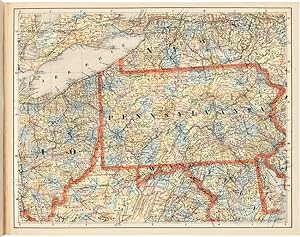
Sixteen color lithographed mapsheets, each 15 1/2 x 19 3/4 inches, plus [2]pp. explanatory text. Large oblong folio. Original printed paper- covered boards, cloth backstrip. Minor rubbing and edge wear, light staining. Internally clean. Very good plus. A rare and unusual atlas for the eastern half of the United States, printed in German by noted American mapmaker J. Calvin Smith. Fifteen of the sixteen mapsheets comprise a sectional map, intended to be pieced together to create a very large map of the eastern United States, extending westward to parts of Texas, Indian Territory (later Oklahoma), and Nebraska. The sixteenth mapsheet is a general map of the United States, including a good portion of lower Canada and the Caribbean, extending southward to Venezuela. The sheet of explanatory text pictures the sectional map if assembled correctly from the fifteen sheets. This atlas was issued during a period of great German emigration to the United States, and it was clearly intended for the use of emigrants and emigration offices - it would have been of great use to them. Most of the time Smith's maps are encountered as American productions. Considering the flood of German emigration to the United States in the mid-19th century, it is logical that this map was printed to encourage the practice, and therefore commissioned by German investors in the United States. This German edition of Smith's map is rarer than his American productions with Colton. KARROW I:1626. KARPINSKI 177 (dating it 1850). RUMSEY 3471 (ref). Bestandsnummer des Verk�ufers WRCAM54266
Bibliografische Details
Titel: SPECIAL-KARTE DER VEREINICTEN STAATEN VON ...
Verlag: Theodor Fischer, Cassel
Erscheinungsdatum: 1852
Beste Suchergebnisse bei AbeBooks

SPECIAL-KARTE DER VEREINICTEN STAATEN VON NORD-AMERIKA.MAP OF THE UNITED STATES OF AMERICA.
Verlag:
Cassel: Theodor Fischer, [ca.1852]., 1852
Gebraucht
Anbieter: William Reese Company - Americana, New Haven, CT, USA
Verk�uferbewertung 4 von 5 Sternen
![]()
Sixteen color lithographed mapsheets, each 15� x 19� inches, plus [2]pp. explanatory text. Large oblong folio. Original printed paper-covered boards, cloth backstrip. Minor rubbing and edge wear, light staining. Internally clean. Very good plus. A rare and unusual atlas for the eastern half of the United States, printed in German by noted American mapmaker J. Calvin Smith. Fifteen of the sixteen mapsheets comprise a sectional map, intended to be pieced together to create a very large map of the eastern United States, extending westward to parts of Texas, Indian Territory (later Oklahoma), and Nebraska. The sixteenth mapsheet is a general map of the United States, including a good portion of lower Canada and the Caribbean, extending southward to Venezuela. The sheet of explanatory text pictures the sectional map if assembled correctly from the fifteen sheets. This atlas was issued during a period of great German emigration to the United States, and it was clearly intended for the use of emigrants and emigration offices - it would have been of great use to them. Most of the time Smith's maps are encountered as American productions. Considering the flood of German emigration to the United States in the mid-19th century, it is logical that this map was printed to encourage the practice, and therefore commissioned by German investors in the United States. This German edition of Smith's map is rarer than his American productions with Colton. KARROW I:1626. KARPINSKI 177 (dating it 1850). RUMSEY 3471 (ref). Bestandsnummer des Verk�ufers 54266
Anzahl: 1 verf�gbar