
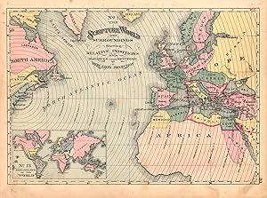
The Scripture World and Surroundings Showing Relative Positions and Distances from New York, and Religions of the World
H.H. Hardesty & Co.
Erscheinungsdatum: 1881
Gebraucht
Verk�ufer
Art Source International Inc., Boulder, CO, USA
Verk�uferbewertung 3 von 5 Sternen
![]()
AbeBooks-Verk�ufer seit 13. Juli 2001
Dieses Exemplar ist nicht mehr verf�gbar. Hier sind die �hnlichsten Treffer f�r The Scripture World and Surroundings Showing Relative Positions and Distances from New York, and Religions of the World von H.H. Hardesty & Co..
Beschreibung
Beschreibung:
These maps intended as references and instructional tools were published in the late 19th century by one of the larger American publishers. They supply good reference for Bible stories and religious education. With bold original outline hand color we see the key areas described in both the Old and New Testaments.This map measures 10 inches by 13.5 inches. Bestandsnummer des Verk�ufers 28260
Bibliografische Details
Titel: The Scripture World and Surroundings Showing...
Erscheinungsdatum: 1881
Beste Suchergebnisse bei AbeBooks

Foto des Verk�ufers
The Scripture World and Surroundings Showing Relative Positions and Distances from New York, and Religions of the World
Gebraucht
Anbieter: Art Source International Inc., Boulder, CO, USA
Verk�uferbewertung 3 von 5 Sternen
![]()
This antique map originally appeared in the "Historical Hand-Atlas" produced in 1882 by H.H. Hardesty & Co. These maps show many details including cities and towns, lakes and rivers, and most important the existing railroad network. This map measures 14 inches by 10 inches. Bestandsnummer des Verk�ufers 28456
Anzahl: 2 verf�gbar