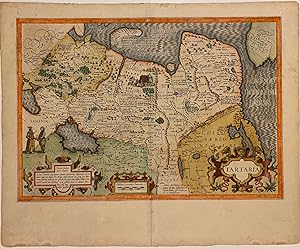
Tartaria
HONDIUS, Jodocus
Verkäufer
Argosy Book Store, ABAA, ILAB, New York, NY, USA
Verkäuferbewertung 5 von 5 Sternen
![]()
Heritage Bookseller
AbeBooks-Mitglied seit 1996
Beschreibung
Beschreibung:
Map. Engraving with original hand coloring. Image measures 13 1/2" x 19 1/2", sheet measures 17 3/4" x 21 7/8" Beautiful and rare map of Tartary, extending from the Black Sea to the Pacific, and from Central Asia to the Arctic. Some notable features on this map include the Great Wall of China, Korea depicted as an island, and an early inclusion of present-day Alaska in the upper right corner with Cape Fortuna and the Straits of Anian labeled. Cities, rivers, and topographical features are labeled. Mountains and forests are depicted pictorially. Illustrations on the map depict Tatar and Samoyed figures, as well as a nomadic structure and domestic animals. This map is in very good condition, with overall wear to margins and along the original centerfold. Archival repair to centerfold at lower margin. French text on verso. Jodocus Hondius (1563-1612) was the founder of a prolific map publishing business, which helped to propel the Dutch dominate 17th c. cartography. When Jodocus the elder died in 1612, his wife Colette ran the business until their sons came of age to join the firm. During this time, their daughter Elisabeth married Johannes Jansson and the two of them helped Colette run the business. Jodocus & Colette's youngest son, Henricus Hondius (1597-1651) later ran the business along with his extended family. Bestandsnummer des Verkäufers 309085
Bibliografische Details
Titel: Tartaria
Verlag: Amsterdam
Einband: unbound
Beste Suchergebnisse bei AbeBooks
"Tartaria" - Russia Tartary Siberia Russland map Karte carte
Anbieter: Antiquariat Steffen Völkel GmbH, Seubersdorf, Deutschland
Original Kupferstich-Karte aus einer lateinischen Ausgabe von Bertius' "Atlas Minor" gedruckt in Amsterdam bei J. Hondius im Jahre 1618. Mit lateinischem Text auf der Rückseite. -- Blatt-Maße: ca. 12 x 19 cm. -- gut erhalten. || Original engraved map out of a Latin edition of Bertius' "Atlas Minor", published by J. Hondius in Amsterdam in 1618. With Latin text on verso. -- in good condition. la Gewicht in Gramm: 10. Bestandsnummer des Verkäufers 231670
Anzahl: 1 verfügbar
"Tartaria" - Russia Tartary Siberia Russland map Karte carte
Anbieter: Antiquariat Steffen Völkel GmbH, Seubersdorf, Deutschland
Kupferstich-Karte aus der ersten französischen Ausgabe von Bertius' "Atlas Minor" gedruckt in Amsterdam bei J. Hondius im Jahre 1618. Mit französischem Text auf der Rückseite. -- Maße: ca. 9,5 x 13,5 cm. -- mit winzigem Wurmlöchlein, sonst gut erhalten. || Copper engraved map out of the first French edition of Bertius' "Atlas Minor", published by J. Hondius in Amsterdam in 1618. With French text on verso. -- with tiny wormhole, otherwise in good condition. la Gewicht in Gramm: 10. Bestandsnummer des Verkäufers 301898
Anzahl: 1 verfügbar
TARTARIA: DESCRIPTION DE TARTARIE: MAP
Anbieter: Hornseys, Ripon, Vereinigtes Königreich
No Binding. Zustand: Very Good Plus. 1st Edition thus. DH302202. Original and scarce miniature map of the region of Tartary. Shows the Strait of Anian, the Mare de Sala or Caspian Sea and the great Wall of China. Printed in 1618 in 'La Geographie Racourcie' in Paris. Size: 13.8cm x 9.7cm. Original copper engraving. Map features a decorative title with text in Latin and a scale in miles. French title above the map with French text to the reverse. Age staining to the margins which only very slightly affects the map. Minor ink annotation to the base of the map. In very good, clean condition overall. These miniature maps by Bertius and engraved by Hondius have been referred to as 'undoubtedly the finest set of miniature maps ever printed'. Bestandsnummer des Verkäufers 000305
Anzahl: 1 verfügbar
Tartaria
Anbieter: libreria antiquaria perini Sas di Perini, Verona, VR, Italien
Incisione in rame, mm 140x185. Tratta dall'edizione di Janssonius dell'"Atlas Minor" di Hondius, pubblicato nel 1606 per la prima volta dopo l'acquisto, da parte del costruttore di globi Hondius, delle lastre di Mercatore con l'aggiunta di lastre originali di propria creazione. Buon esemplare; margine superiore rifilato con leggera perdita del titolo. Nr.cat: 100_6911. Bestandsnummer des Verkäufers 6190
Anzahl: 1 verfügbar
Tartaria.
Anbieter: Altea Antique Maps, London, Vereinigtes Königreich
Amsterdam: Jodocus Hondius, 1616. Coloured. 100 x 135mm. Miniature map of Tartary, with 'the Strait of Anian' and the Great Wall of China marked, engraved by Jodocus Hondius for his edition of Petrus Bertius's 'Tabularum Geographicarum Contractarum'. Unlike the earlier plate, this version has longitude and latitude lines. KOEMAN: Lan 11a, 'With the new plates, the work was certainly improved. Bestandsnummer des Verkäufers 15209
Anzahl: 1 verfügbar

