Beschreibung
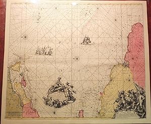
WIT, Frederick de (1630-1706). Terra Nova, ac Maris Tractus circa Novam Franciam, Angliam, Belgium, Venezuelam Novam Andalusiam, Guianam et Brasiliam / Terra Neuf, en de Custen van Nieuw Vranckryck, Nieu Engeland, Nieu Nederland, Nieu Andalusia, Guiana en Venezuela. Amsterdam: Louis Renard, ca. 1715. Single sheet (20 x 23 4/8 inches; full margins showing the plate mark). A fine engraved map of the Atlantic, with original handcolour in full, showing the east coast of North America, decorated with two large elaborate allegorical title cartouches, four galleons sailing the Atlantic, 2 compass roses, rhumb lines and a scale lower left. Third state of De Wit s sea chart of the Atlantic ocean showing the coast of New England, the Caribbean Islands and the coast of Venezuela, derived from Theunis Jacobsz ca. 1650, first published as here in de Wit's "Zee Atlas". Probably engraved by Romein de Hooghe, Louis Renard has faithfully reprinted the map, altering only the imprint and improving the depiction of Chesapeake Bay. "Dutch optimism at recovering New Amsterdam is seen in the familiar naming of the colony in the two titles. Early issues bear the pagination 22 top right [this issue numbered '26'] .For the third state some additional toponyms were included. In North America these included MARILAND. B. de Delaware and Grand Banc de Mallabarre". Burden 467. Bestandsnummer des Verkäufers 72map375
Verkäufer kontaktieren
Diesen Artikel melden
![]()
