


A Topographical Dictionary of England, Comprising the Several Counties, Cities, Boroughs, corporate and market towns, parishes, chapelries and townships, and the Islands of Guernsey, Jersey, and Man, with historical and statistical descriptions; illustrated by maps of the different counties and islands; A Map of England, shewing the principle towns, roads, railways, navigable rivers, and canals; and a plan of London and its environs; and embellished with engravings of the arms of the cities, bishopricks, universities, colleges, corporate towns and boroughs; and of the seals of the several municiple corporations. Four volumes complete.
LEWIS, SAMUEL:
Verlag: London, S. Lewis and Co., 1831 1st
Gebraucht
Verkäufer
PROCTOR / THE ANTIQUE MAP & BOOKSHOP, DORCHESTER, Vereinigtes Königreich
Verkäuferbewertung 5 von 5 Sternen
![]()
AbeBooks-Verkäufer seit 22. März 2001
Verbandsmitglied:
Dieses Buch ist nicht mehr verfügbar. AbeBooks führt Millionen von Büchern. Bitte geben Sie unten Suchbegriffe ein, um ähnliche Exemplare zu finden.
Beschreibung
Beschreibung:
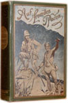
Four Volumes. Hardbacks, 11 x 9 inches. 4to. Halfbound black morocco leather to spines and corners and decorative black embossed floral patterend cloth to boards. With gilt line edging to boards, raised banding and full gilt decorations and lettering to spines. Full marbled page edges and endpapers. In very good condition. Some shelfwear and rubbing to covers, leading corners bumped and chipped, one small chip to top end of spine on vol.1. Minor cracks between endpapers else bindings tight and sound. Bookplates to front endpapers ?M.C.M.? Some minor light foxing spots to blank prelims. No penned inscriptions. Inside pages all very clean and bright throughout. Maps all very clean and bright, one or two occasional minor light foxing spots, some of the folding maps are a little more darkened and foxed. Some minor offsetting to large Country map, small tear to bound corner, and minor tear along bottom corner fold. Else a very good clean and tight set. 4 vols. Illustrated with 45 B&W engraved maps of the Counties of England and Wales, including 15 fold-out maps, and a large folding map of the whole Country. B&W figures of Seals and Crests within text. Four volumes complete, rebound, probably in 1930s. Entries are in alphabetical order and give descriptions as above. Maps engraved by J&C Walker. Bestandsnummer des Verkäufers 96262
Bibliografische Details
Titel: A Topographical Dictionary of England, ...
Verlag: London, S. Lewis and Co., 1831 1st
AbeBooks ist ein Internet-Marktplatz für neue, gebrauchte, antiquarische und vergriffene Bücher. Bei uns finden Sie Tausende professioneller Buchhändler weltweit und Millionen Bücher. Einkaufen bei AbeBooks ist einfach und zu 100% sicher — Suchen Sie nach Ihrem Buch, erwerben Sie es über unsere sichere Kaufabwicklung und erhalten Sie Ihr Buch direkt vom Händler.
Millionen neuer und gebrauchter Bücher bei tausenden Anbietern
Neue und gebrauchte Bücher

Neue und gebrauchte Exemplare von Neuerscheinungen, Bestsellern und preisgekrönten Büchern. Eine riesige Auswahl an günstigen Büchern.
Antiquarische Bücher
Von seltenen Erstausgaben bis hin zu begehrten signierten Ausgaben ? bei AbeBooks finden Sie eine große Anzahl seltener, wertvoller Bücher und Sammlerstücke.
Versandkostenfreie Bücher
Hier finden Sie viele hunderttausend neue, gebrauchte und antiquarische Bücher, die Ihnen unsere deutschen und internationalen Händler versandkostenfrei liefern.