Beschreibung
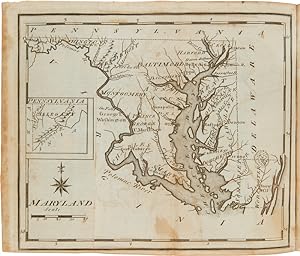
Engraved titlepage, [iii]-vi, errata leaf, blank leaf, [292]pp. Text printed in double columns. Nineteen engraved folding maps, including the large folding frontispiece map. 12mo. Contemporary tree sheep, red morocco label. Boards rubbed, mostly along the spine and edges. Two-inch closed tear in edge of frontispiece map (where bound in). Offsetting from the maps. Very good. The first gazetteer of the United States, with an important series of engraved American maps. These, with the maps in Carey's AMERICAN ATLAS that were issued the same year, represent a major step forward in American cartography. Scott's maps cover the United States in general, Connecticut, Delaware, Georgia, New Jersey, Kentucky, Maine, Maryland, Massachusetts, New Hampshire, New York, North Carolina, Pennsylvania, Rhode Island, South Carolina, Vermont, Virginia, the Northwest Territory, and the Southwest Territory. An important early work of U.S. cartography and among the earliest mappings of each state. HOWES S237. SABIN 78331. EVANS 29476. CLARK III:123. WHEAT & BRUN 125. REESE, FEDERAL HUNDRED 54. Bestandsnummer des Verkäufers WRCAM50462F
Verkäufer kontaktieren
Diesen Artikel melden
![]()


