Gesamtpreis (1 Artikel Artikel):
Versandziel:

ANDRIVEAU GOUJON J (59 Ergebnisse)
Direkt zu den wichtigsten Suchergebnissen
Produktart
- Alle Produktarten
- Bücher (43)
- Magazine & Zeitschriften
- Comics
- Noten
- Kunst, Grafik & Poster (4)
- Fotografien
- Karten (12)
-
Manuskripte &
Papierantiquitäten
Zustand
Einband
Weitere Eigenschaften
- Erstausgabe (3)
- Signiert
- Schutzumschlag
- Angebotsfoto (30)
- Kein Print-on-Demand (58)
Gratisversand
Land des Verkäufers
Verkäuferbewertung
-
![Bild des Verkäufers für Atlas des 20 arrondissements de Paris (1862) [LeatherBound] zum Verkauf von True World of Books](https://pictures.abebooks.com/inventory/md/md31618291215.jpg)
Atlas des 20 arrondissements de Paris (1862) [LeatherBound]
Erscheinungsdatum: 2023
Buch Print-on-Demand
LeatherBound. Zustand: New. LeatherBound edition. Condition: New. Reprinted from 1862 edition. Leather Binding on Spine and Corners with Golden leaf printing on spine. Bound in genuine leather with Satin ribbon page markers and Spine with raised gilt bands. A perfect gift for your loved ones. NO changes have been made to the original text. This is NOT a retyped or an ocr'd reprint. Illustrations, Index, if any, are included in black and white. Each page is checked manually before printing. As this print on demand book is reprinted from a very old book, there could be some missing or flawed pages, but we always try to make the book as complete as possible. Fold-outs, if any, are not part of the book. If the original book was published in multiple volumes then this reprint is of only one volume, not the whole set. Sewing binding for longer life, where the book block is actually sewn (smythe sewn/section sewn) with thread before binding which results in a more durable type of binding. Pages: 74.
-
Carte Physique et Routiere de Las Suisse Public (New Edition)
Erscheinungsdatum: 1855
Buch
Hardcover. Zustand: Very Good. New Edition. Large fold out map bound in hardcover. Blue and green cloth covers with gilt lettering. Map has a few small smudges. Back of map has some discoloration and owners name. Covers have rubbing and discoloration. Spine is sunned. Overall a very nice copy. Full refund if not satisfied.
-

Carte Générale Des Routes et des Chemins de Fer de La France (most probably first edition, later edition is known from 1891). - Folding map; dissected into 21 sections and mounted on linen. ca 64x79cm Lithograph. Full original color. (A highly detailed road map of France near the end of the nineteenth century. The map shows all the major roads throughout France as well as the railroads, the two transportation networks forming an impressive web covering every part of the country. This folding map was intended for use by travelers and its detail would certainly would have made it an excellent tool by those moving about France. Other details include the roads and railroads of southern England and detailed inset of Paris). In good condition (2 minor black dots - about a thumb- in the center).
Verlag: E.Andriveau-Goujon,Paris, 1887
Anbieter: Fabri Antiquariat Dr. Jürgen Aschoff, Ulm, BW, Deutschland
Bewertung:

Erstausgabe
Carte Générale Des Routes et des Chemins de Fer de La France (most probably first edition, later edition is known from 1891). - Folding map; dissected into 21 sections and mounted on linen. ca 64x79cm Lithograph. Full original color. (A highly detailed road map of France near the end of the nineteenth century. The map shows all the major roads throughout France as well as the railroads, the two transportation networks forming an impressive web covering every part of the country. This folding map was intended for use by travelers and its detail would certainly would have made it an excellent tool by those moving about France. Other details include the roads and railroads of southern England and detailed inset of Paris). In good condition (2 minor black dots - about a thumb- in the center). 1 S.
-
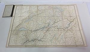
Carte de L'Italie Ancienne at des Contrees Adjacentes [Linen backed map of Italy c1837]
Verlag: Published by J. Andriveau-Goujon, Paris, 1837
Karte Erstausgabe
, linen backed map of ancient Italy partly coloured and dated 1837, map no. 7 of Atlas Universel, inset map of Rome Ancienne First Edition , some light foxing to map, previous owner's name to rear dated 1842, very good condition , paper slipcase worn with part of bottom missing, fair condition , linen backed map , 52 cm x 41 cm (open) Paperback ISBN:
-
Carte de l'Italie ancienne et des contrées adjacentes
Verlag: Paris, Andriveau-Goujon, 1843, 1843
grande carte dépliante de 53 x 67,5 cm, contours rehaussés de couleurs, en feuilles, entoilées. Rousseurs assez abondantes. Carte ŕ l'usage de l'apprentissage de l'histoire romaine.
-
Carte générale des routes de France a l'Usage des Voyageurs. Grenzkolorierte Karte, frischer sauber Zustand. In 28 Teilem, auf Leinen aufgezogen, gefaltet (Faltkarte in kolor. Stahlstich auf Leinen). In der Original-Papphülse, diese leicht berieben.
Verlag: ANDRIVEAU-GOUJON,Paris, 1831
Anbieter: Fabri Antiquariat Dr. Jürgen Aschoff, Ulm, BW, Deutschland
Bewertung:
Carte générale des routes de France a l'Usage des Voyageurs. Grenzkolorierte Karte, frischer sauber Zustand. In 28 Teilem, auf Leinen aufgezogen, gefaltet (Faltkarte in kolor. Stahlstich auf Leinen). In der Original-Papphülse, diese leicht berieben. 1 S.
-
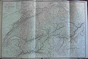
Cartes Physique et Routičre de la Suisse. Original engraved Print. Antique Engraving
Erscheinungsdatum: 1835
Kunst / Grafik / Poster
Original print. Engraved area measures: 50 x 74 cm. Marginal fissures. Antique map, outline Color. Cartes Physique et Routičre de la Suisse Publiée par J. Andriveau-Goujon. Rue de Bac, No. 6. Paris 1835. Engraved A. Zurich, chez Henry Fuessli & Cie. A Genčve, chez Le Double. Atlas Universel No. 17. OCLC:637439796. Druckgrafik.
-
L'Empire Romain depuis Constantin jusq'ŕ la fin du 4° Siecle (Atlas de Géographie ancienne et moderne adopté pour le Bibliotheques Militaures).
Verlag: Andriveau-Goujon., Paris., 1850
Carta geografica, cm. 44,5 x 55,5 ca. Cartiglio in basso a sinistra. Confini colorati. Piccolo strappo al centro del marg. inf. che interessa la carta medesima.
-
Algérie (Atlas de Géographie ancienne et moderne adopté pour le Bibliotheques Militaures).
Verlag: Andriveau-Goujon., Paris., 1851
Carta geografica, cm. 44,5 x 65 ca. Confini colorati. Cartiglio in alto a sinistra. Il marg. destro č ripiegati. Piccolo strappo al marg. inf. che interessa la carta medesimo.
-
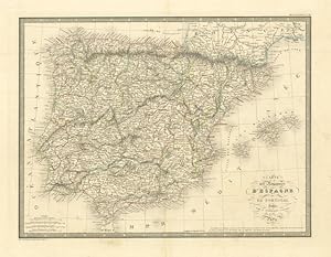
Carte des Royaumes d'Espagne et de Portugal
Verlag: Spagna - Portogallo (Espańa - Portugal)
Anbieter: Sergio Trippini, Gavirate, Italien
Bewertung:

Carta geografica della Spagna e del Portogallo. Confini in coloritura coeva, piega centrale editoriale.
-
![Bild des Verkäufers für Carte des Royaumes d?Espagne et de Portugal [Mapa antiguo de Espańa y Portugal] zum Verkauf von Bolivar Old Prints Anticuario](https://pictures.abebooks.com/inventory/md/md31742336247.jpg)
Carte des Royaumes d?Espagne et de Portugal [Mapa antiguo de Espańa y Portugal]
Verlag: París, 1845
Anbieter: Bolivar Old Prints Anticuario, Barcelona, BARCE, Spanien
Verbandsmitglied: AILA
Bewertung:
Karte
Zustand: Good. Detallado mapa de Espańa y Portugal realizado por J. Andriveau-Goujon en 1845 y publicado en 1847 en el Atlas Classique et Universel de Géographie Ancienne et Moderne, en París. Andriveau-Goujon (1832-1897) fue un editor y cartógrafo parisino que publicó numerosos mapas y atlas a lo largo del siglo XIX y con frecuencia trabajó con otros prominentes cartógrafos de la talla de Brue y Levasseur. El inventario de su firma editorial fue adquirido por M. Barrere en 1892. 50 x 38.5 cm.
-
CARTE DE LA MONARCHIE SUEDOISE ET DU ROYAUME DE DANEMARK . Map of Scandinavia with inset maps of Denmark and Iceland.
Verlag: J. Andriveau 1845, 1845
Karte
50x38cm. Original outline Colour.
-
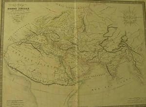
Monde ancien (Atlas de Géographie ancienne et moderne adopté pour le Bibliotheques Militaures).
Verlag: Andriveau-Goujon., Paris., 1850
Carta geografica, cm. 44,5 x 55,5 ca. Cartiglio in alto a sinistra. Rosa dei venti in alto a destra. Confini colorati. Piccolo strappo in basso al centro.
-
La Palestine (Atlas de Géographie ancienne et moderne adopté pour le Bibliotheques Militaures).
Verlag: Andriveau-Goujon., Paris., 1850
Carta geografica, cm. 44,5 x 55,5 ca. Cartiglio in alto a sinistra. Pianta di Gerusalemme A.C. in basso a destra. In parte colorata.
-
Italie ancienne (Atlas de Géographie ancienne et moderne adopté pour le Bibliotheques Militaures).
Verlag: Andriveau-Goujon., Paris., 1850
Carta geografica, cm. 55,5 x 44,5 ca. Cartiglio in alto a destra. Confini colorati. Piccolo strappo al centro del marg. destro che interessa la carta medesima.
-
Espagne et Portugal (Atlas de Géographie ancienne et moderne adopté pour le Bibliotheques Militaures).
Verlag: Andriveau-Goujon., Paris., 1850
Carta geografica, cm. 44,5 x 55,5 ca. Cartiglio in basso a destra. Confini colorati. Piccolo strappo al centro del marg. inf. che interessa la carta medesima.
-
France par provinces (Atlas de Géographie ancienne et moderne adopté pour le Bibliotheques Militaures).
Verlag: Andriveau-Goujon., Paris., 1850
Carta geografica, cm. 44,5 x 55,5 ca. Confini colorati. Cartiglio al centro a sinistra. Piccolo strappo al marg. inf. che interessa la carta medesima.
-
Sučde et Danemark (Atlas de Géographie ancienne et moderne adopté pour le Bibliotheques Militaures).
Verlag: Andriveau-Goujon., Paris., 1850
Carta geografica, cm. 55,5 x 44,5 ca. Confini colorati. Cartiglio in basso a sinistra. In alto a sinistra ed in basso a destra sono riportate le carte della Danimarca e dell'Islanda.
-
L'Angleterre, l'Ecosse et l'Irlande (Atlas de Géographie ancienne et moderne adopté pour le Bibliotheques Militaures).
Verlag: Andriveau-Goujon., Paris., 1852
Carta geografica, cm. 55,5 x 44,5 ca. Confini colorati. Cartiglio in alto a destra. In alto a sinistra sono riprodotte le Isole Shetland. Piccoli strappi sul marg. destro e sinistro.
-
Hollande et Belgique (Atlas de Géographie ancienne et moderne adopté pour le Bibliotheques Militaures).
Verlag: Andriveau-Goujon., Paris., 1851
Carta geografica, cm. 55,5 x 44,5 ca. Confini colorati. Cartiglio in alto a sinistra. Piccoli strappi sul marg. destro e sinistro.
-
France divisée en 86 departements (Atlas de Géographie ancienne et moderne adopté pour le Bibliotheques Militaures).
Verlag: Andriveau-Goujon., Paris., 1851
Carta geografica, cm. 51 x 68 ca. Confini colorati. Il marg. inf. e quello destro sono ripiegati.
-
Suisse et Etats-Sardes (Atlas de Géographie ancienne et moderne adopté pour le Bibliotheques Militaures).
Verlag: Andriveau-Goujon., Paris., 1850
2 carte geografiche, cm. 55,5 x 44,5 ca. ognuna. Cartiglio in alto a sinistra (della 1^ carta). Confini colorati. Piccolo strappo al centro del marg. sinistro che interessa la carta medesima.
-
Allemagne (Atlas de Géographie ancienne et moderne adopté pour le Bibliotheques Militaures).
Verlag: Andriveau-Goujon., Paris., 1850
Carta geografica, cm. 44,5 x 55,5 ca. Cartiglio in alto a destra. Confini colorati. Piccolo strappo al centro del marg. inf. che interessa la carta medesima.
-
Egypte, Nubie et Abyssinie, etc. (Atlas de Géographie ancienne et moderne adopté pour le Bibliotheques Militaures).
Verlag: Andriveau-Goujon., Paris., 1850
Carta geografica, cm. 55,5 x 44,5 ca. Cartiglio in alto a destra. Confini colorati.
-
Italie, la Suisse le Tyrol et le provinces Illyriennes (Atlas de Géographie ancienne et moderne adopté pour le Bibliotheques Militaures).
Verlag: Andriveau-Goujon., Paris., 1850
Carta geografica, cm. 55,5 x 44,5 ca. Cartiglio in alto a destra. Confini colorati. Piccoli strappi al centro del marg. destro e sinistro che interessano la carta medesima.
-
Gaule (Atlas de Géographie ancienne et moderne adopté pour le Bibliotheques Militaures).
Verlag: Andriveau-Goujon., Paris., 1850
Carta geografica, cm. 44,5 x 55,5 ca. Cartiglio in alto a destra. Confini colorati. Piccolo strappo al centro del marg. inf. che interessa la carta medesima.
-
Afrique (Atlas de Géographie ancienne et moderne adopté pour le Bibliotheques Militaures).
Verlag: Andriveau-Goujon., Paris., 1850
Carta geografica, cm. 44,5 x 55,5 ca. Cartiglio in alto a sinistra. Confini colorati. Piccolo strappo al centro del marg. inf. che interessa la carta medesima.
-
Empire Chinois (Atlas de Géographie ancienne et moderne adopté pour le Bibliotheques Militaures).
Verlag: Andriveau-Goujon., Paris., 1851
Carta geografica, cm. 44,5 x 55,5 ca. Cartiglio in basso a destra. Confini colorati. Piccolo strappo al centro del marg. inf. che interessa la carta medesima.
-
Océanie (Atlas de Géographie ancienne et moderne adopté pour le Bibliotheques Militaures).
Verlag: Andriveau-Goujon., Paris., 1850
Carta geografica, cm. 44,5 x 55,5 ca. Cartiglio in alto a destra. In basso a destra č riportato in dettaglio il Nuovo Galles Meridionale. Confini colorati. Piccolo strappo al centro del marg. inf. che interessa la carta medesima.
-
Etats - Unis (Atlas de Géographie ancienne et moderne adopté pour le Bibliotheques Militaures).
Verlag: Andriveau-Goujon., Paris., 1850
Carta geografica, cm. 44,5 x 55,5 ca. Confini colorati. Cartiglio in basso a destra. Piccoli strappi sul marg. destro e sinistro.

![Bild des Verkäufers für Carte de L'Italie Ancienne at des Contrees Adjacentes [Linen backed map of Italy c1837] zum Verkauf von Keoghs Books](https://pictures.abebooks.com/inventory/md/md22845782084.jpg)