Gesamtpreis (1 Artikel Artikel):
Versandziel:

ANTONIO LAFRERI (13 Ergebnisse)
Direkt zu den wichtigsten Suchergebnissen
Produktart
- Alle Produktarten
- Bücher (4)
- Magazine & Zeitschriften
- Comics
- Noten
- Kunst, Grafik & Poster (6)
- Fotografien
- Karten (3)
-
Manuskripte &
Papierantiquitäten
Zustand
- Alle
- Neu
- Antiquarisch/Gebraucht
Einband
- alle Einbände
- Hardcover (1)
- Softcover
Weitere Eigenschaften
- Erstausgabe
- Signiert
- Schutzumschlag
- Angebotsfoto (10)
- Kein Print-on-Demand
Gratisversand
Land des Verkäufers
Verkäuferbewertung
-
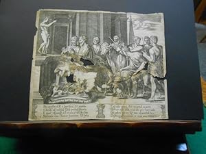
Opferszene für den Gott Rč, mit zahlreichen figürlichen Darstellungen. Original- Kupferstich ca. 1550. Rechts unten bezeichnet, Ant. Sal. exc. Antonio Lafreri (auch Antoine Lafréry)
Anbieter: Galerie Antiquariat Schlegl, Weiden i. d. OPf., Deutschland
Bewertung:

Kunst / Grafik / Poster
Inhalt: Allegorie Götzenanbetung; Interessante Opferszene für den Gott Rč mit reicher Staffage. Sieben Personen in antiker Gewandung bringen teils in heftiger Diskussion einen geschmückten Stier und 2 Widder zum Opferaltar. Original Kupferstich von Antonio Lafreri (auch Antoine Lafréry, * 1512 in Orgelet, Frankreich; 1577 in Rom). Er war ein in Rom ansässiger Drucker, Kartenhändler und Verleger französischer Herkunft während der Renaissance. Signatur Ant. Sal.exc. Am unteren Bildrand folgendes Gedicht in italienischer Sprache: Per questo il Rč sacrifica partito- chiede al milesio Dio perlafigliuola Il Qual risponde, ŕ l er nio e nculto lito Menalaocon l honor funereo sola. Lasciala quiui, che mortal marito Hauer non dee, ma chi per l aer nola Di uelen pieno con immortal foco distrugge l et mai non troua loco. Zustand: Original- Kupferstich stärker lädiert, löcherig, gebräunt, Blattrand beschnitten, sonst noch trotz der vielen Beschädigungen noch passabel erhalten. Sprache: Deutsch Gewicht in Gramm: 1050 Plattenrand- Größe: 19,5 x 23 cm.
-

Janus de Rome. Ansicht des Janusbogens, vor der Restaurierung.
Erscheinungsdatum: 1750
Kunst / Grafik / Poster
Zustand: Gut. Kupferstich nach Lafreri, um 1750, Lafreri, Antonio deu S 9|2DG Sprache: Deutsch Gewicht in Gramm: 444 Bildformat: 31 x 32 cm. Blattformat: 36,5 x 51 cm.
-
58th plate of 100 portraying Rome's palaces and ruins and even reconstruction of ancient buildings in Rome. The second state of these etchings were collected in the publication by Peter Schenck:'Roma aeterna, sive ipsius aedificiorum Romanorum, integrorium collapsorumque, conspectus duplex. ' In the 'Aedificiorum Index':'58. Sepulcrum, Septizonium Severi', view on the ruins of the so called Septizonium, a building constructed by will of emperor Septimius Severus, completely dismanteled by 1600. For this representation the source might have been a plate from Lafreri's 'Speculum Romanae Magnificentiae' (1574). Inscribed on the bottom in Latin and Dutch:'SEPTIZONIUM SEVERI. / P. Schenck exc: Amstelod: cum Privil:'l Etching on paper with margins; platemark: 167 x 198 mm; total: 191 x 254 mm; state I/2; some dirt along the external margins; Hollstein 1497-1596; Nagler 177; Le Blanc 19; Wurzbach 313.
-
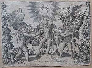
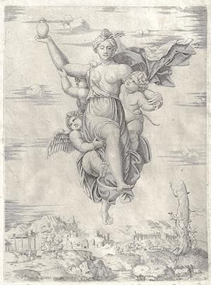
Amorini offrono ad un fanciullo coronato delle coppe colme d'oro (o Putti con Insegna).
Erscheinungsdatum: 1549
Anbieter: BOTTEGHINA D'ARTE GALLERIA KÚPROS, Rosignano Solvay, LI, Italien
Bewertung:

Kunst / Grafik / Poster
No legatura. Zustand: buono. Parigi, probabile post 1525 ante 1549. Incisione a bulino, cm 20,9 x 28,5 (l'inciso) 21,4 x 29 (il foglio). In lastra, in basso al centro, "Gio: Iacomo Rossi formis Romae alla Pace all'insegna di Parigi, 1655"; poco sotto sulla sn. "Rapha. Ur. In."; poco piů avanti "Tappezzerie del Papa"; sulla destra il dado con la lettera B e "Ant. Lafrerji Formis". Dalla serie delle "Tappezzerie del Papa", da un soggetto di Raffaello e edite da Antonio Lafreri, sono queste incisioni per decorazioni e ornati. Il Maestro del Dado č pittore e incisore della scuola romana di Marcantonio Raimondi, e attivo a Roma tra il 1532 e il 1550. Spesso viene confuso, a torto, con il Beatricetto o con il Bonasone. Il Le Blanc ritiene si tratti di un discendente del pittore Bernardo Daddi (1512 ca. Roma 1570), in base all iniziale che si legge nell attributo figurato che sigla le sue stampe, una B segnata su un dado. Diversamente, altri lo identificano con Benedetto Verini, figlio naturale o presunto di Marcantonio, sciogliendo le iniziali BV che appaiono su alcune sue stampe, mentre, per il Bartsch, l ultima lettera potrebbe avere il significato di Veneziano o, piů recentemente (ma ancora dubitativamente), di Tommaso Vincidor da Bologna. Incisore di riproduzione di opere altrui, eseguite talvolta su richiesta di Antonio Lafrery, i suoi modelli prediletti sono Raffaello, Peruzzi, Giulio Romano e Tommaso Vincidor. Al Maestro del Dado vengono assegnate circa 85 stampe dal Malaspina, il Bartsch elenca sempre 85 sogetti, che il Passavant porta a 89. Esemplare rifilato ai margini ma con visibile la battuta della lastra, alcuni strappetti rimarginati al margine inferiore, ottima impressione.
-
Petri de Nobilibus Formis
Verlag: Artist: Lafreri Antonio ( - 1577 ) Rome; issued in: Rome; Lafreri Antonio ( 1512 - 1577 ) Rome; Antonio Lafreri (1512-1577) was a Rome-based printer and publisher of French origin during the Renaissance Lafreri was the first to publish volumes of geographic maps in a uniform- format the so-called Lafreri atlases Lafreri came from Franche-Comté and settled in Rome where he acquired numerous copper plates from Marcantonio Raimondis In the 1940s he published his own prints with views of ancient and modern Rome and after 1548 over 130 of these engravings appeared under the title "Speculum romanae grandiaia" (A Mirror of the Splendor of Rome) The work was very well received by travelers and made Lafreri the first major graphics publisher Around, 1512
Anbieter: Antique Sommer& Sapunaru KG, München, Deutschland
Bewertung:

Kunst / Grafik / Poster
Technic: Copper print; colorit: black/white; condition: Perfect condition; size (in cm): 29,5 x 22 cm; ;Peter from a noble form; copperprint. Printed from Paolo Graziani (Italian, active Rome, 1577?84).
-
Claudii et Traiani impp. admirabilium portuum Ostiensium
Verlag: Rome: Lafreri, 1575, but ca 1630, 1630
LAFRERI, Antonio (1512-1577). Claudii et Traiani impp. admirabilium portuum Ostiensium. Orthographia per Stephanum du Perach, architectum iuxta antiqua vestigia accuratissime delineata. Rome: Io. Iacobus Rubeis, [ca 1660]. 2 sheets, joined (16 x 27 4/8 inches). SUPERB engraved view of the ancient and strategic fortified port of Ostia, Portus, about 2 miles northwest of Ostia, at the mouth of the River Tiber on the shores of the Tyrrhenian sea, as it was in Classical Rome, showing the outer harbour of Claudius with its two moles extending into the sea guarded by a colossus, and the inner hexagonal harbour of Trajan, decorated with ships and a fine compass rose (close-cropped). First issued by the renowned Roman publisher Antonio Lafreri in 1575, and with his imprint. Lafreri was a major map seller and publisher in Rome, and one of the first to issue an atlas of assorted maps with a dedicated engraved title-page. The importance of Ostia as a port city increased dramatically after the emperor Claudius undertook to build two great moles at Portus northwest of Ostia, beginning in AD 42 and taking about 20 years to complete, and eventually dedicated under Nero in 64 AD. The "growth of Ostia into a major urban centre begins at this time; at its height the population is 50,000-70,000 people. Up until that time the anchorage in the mouth of the Tiber was uncertain, the coast also being a lee shore and dangerous. Larger vessels could not navigate the Tiber mouth and so, before the harbour was built, lighters needed to be employed to bring cargo ashore. Claudius new port alleviated all of these factors which had provided a natural check on the growth of the city. Now Ostia became a port town in earnest; the residence of workers at the port as well as of the negotiators who arranged trans-shipment of cargoes upstream. This development coincided with the period in which the grain shipments from Egypt (the Annonaria) were reaching their full extent and these enormous annual shipments of grain added impetus to the growth of the city. "Under Trajan an ambitious expansion to the Portus complex was completed in the years 106-113 CE. This took the form of a large hexagonal harbour just to the east of, and connected to, Claudius outer harbour. After this time the grain fleet from Egypt was brought to Portus and not to Puteoli as it had been until that time" (Ancient History Encyclopedia Limited online).
-
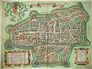
La Imperial' Citta D'Augusta - Il vero ritratto della antiqua, et famosissima Citta Imperiale Augusta
Erscheinungsdatum: 1584
Kunst / Grafik / Poster
Kein Einband. Zustand: Befriedigend. Es handelt sich hierbei um einen originalen, kolorierten und sehr raren Kupferstichplan der Stadt Augsburg aus einem Lafreri Atlas um 1584. *** Titel: La Imperial' Citta D'Augusta - Il vero ritratto della antiqua, et famosissima Citta Imperiale Augusta . Ort: Augsburg *** Kartograph: Antonio Lafreri (1512 - 1577), Ausgabe bei Pietro de' Nobili (Petri de Nobilibus) *** Jahr: um 1584 *** Größe des Plattenbereichs: ca. 36 x 49 cm *** Technik: Kupferstich *** Zustand (Perfekt/ Sehr gut/ Gut/ Ordentlich/ Mäßig/ Schlecht): In ordentlichem Erhaltungszustand. Das Blatt ist vollständig restauriert, hinterlegt und in Teilbereichen auch angerändert. An einigen wenigen, kleinen Stellen (vor allem rechts unterhalb der rechten Kartusche und entlang der Mittelfalte) war der Druckbereich anscheinend beschädigt und wurde restauriert und nachgezeichnet. Trotz der vorhandenen Mängel handelt es sich hierbei um einen sehr dekorativen und aufgrund seiner Seltenheit eindeutig erhaltenswerten frühen Plan von Augsburg. *** Bemerkungen: Tooley 119. Dieser sehr rare Plan wurde zunächst von Antonio Lafreri (1512 - 1577) herausgegebenen, wahrscheinlich orientierte sich dieser an einem Holzschnitt von Hans Rogel aus dem Jahr 1563. Später wurde die Druckplatte nach Lafreris Tod zunächst von seinem Erben Claudio Duchetti verwendet und im November 1584 an Pietro de' Nobili verkauft. Dieser entfernte die bisherigen Verleger- und Stecherangaben aus der rechten Kartusche und ergänzte die Platte um die Urheberangabe 'Petri de Nobilibus Formis'. Legende der wichtigen Gebäude von 1-99. - - - International buyers welcome. If you have any questions, please don't hesitate to ask. --- Auf Wunsch stellen wir Ihnen gerne ein kostenfreies Echtheitszertifikat aus --- If you wish, we will gladly provide a certificate of authenticity free of charge ---.
-
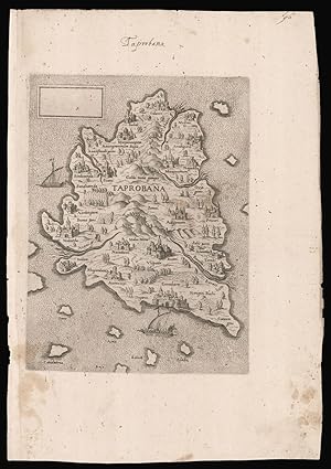
Taprobana.
Verlag: A. Lafreri, c1570]., [Rome,, 1570
Anbieter: Daniel Crouch Rare Books Ltd, London, Vereinigtes Königreich
Verbandsmitglied: ABA ILAB PBFA
Bewertung:

Karte
The only map of Sri Lanka published by the Lafreri school Engraved map, watermark of a letter 'M' under star in shield. A striking map of Sri Lanka attributed to Antonio Lafreri. The map is typical of the Lafreri School with Venetian galleys on the stippled sea, cities and towns represented as bird's-eye views, and hills and trees populating the interior. Although the map is anonymous, the work has been attributed, by Destombes, to the Rome publisher Antonio Lafreri, who lists a map of Sri Lanka in his catalogue - item no. 75. La Barroni suggests that the map is a copy of an earlier map, published in Venice, however, there is no substantive evidence for this. The map would later be acquired by Claudio Duchetti, and then by Giacomo Gherardi, who advises it in his catalogue in 1598 (No.175 "isola tapproban"). The plate would then be purchased by Giovanni Orlandi, and finally by Hendrik van Schoel. Bifolco TAV. 86; cf. Woodward 316-318.
-
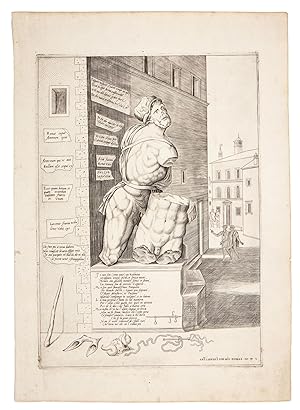
PASQUINO
Verlag: Antonio Lafreri, Rome, 1550
Anbieter: Liber Antiquus Early Books & Manuscripts, Chevy Chase, MD, USA
Bewertung:

Hardcover. Zustand: Fine. First state. With Lafreri's excudit: "Ant. LafrerI FormIs Romae MDL" at lower right. Watermark "Duck in a Circle"(cf. Woodward 79-80). A fine impression, rich in tone, with light marginal foxing and light soiling, particularly in the lower right corner, and some trivial surface soiling to the image. An iconic image of the statue known as Pasquino, by far the most famous of Rome's 'statue parlanti' (talking statues) and the eponymous originator of the pasquinade genre. The statue was discovered in 1501 in the Parione district of Rome. Cardinal Oliviero Carafa, "the embodiment of humanist ideals, centering on the revival of antiquity"(Reynolds), erected the statue next to his palace near Piazza Navona, on the site of today's Palazzo Braschi, where it stands to this day. As early as 1501, satirical poems in Latin and Italian, variously celebrating or criticizing the pope, clergy, and nobility, or lampooning private individuals, were affixed to the statue. By 1508, the statue had become the focus of a yearly celebration, held on St. Mark's Day, during which the statue was dressed as a Roman deity or other mythological figure, and anonymous writers attached to it poems written in the "voice" of the statue. In 1511, Pasquino was dressed as Grief, mourning the death of Cardinal Carafa. In 1549, the year before this print was published, Pasquino famously opined on the death of Pope Paul III: 'Here was buried a certain Paul/ a fraud, a fox, thief, murderer;/ Here famous in the mouth of Pasquino/ There suffering in the mouth of the devil." The artist responsible for this print has included a number of pasquinades, in Latin and Italian, shown on bits of paper attached to the walls of Carafa's palace. The ground in front of the statue is strewn with props, a reference to the costumes worn by Pasquino during the St. Mark's Day celebration. In the distance are two pairs of men, the first standing in the piazza and the second strolling towards the statue. Carafa's arms are visible in the shadow on the statue's base. Lafreri's print is a close copy of one published in 1542 by Antonio Salamanca, Lafreri's rival and eventual business partner. The identity of the artist is unknown. Among those to whom the plate has been attributed are Enea Vico and Nicolas Beatrizet. In the same year (1550) that he produced his Pasquino print, Lafreri issued a related print, the Marforio, another of Rome's talking statues, with whom Pasquino frequently held "conversations". The origin of the name "Pasquino" has been debated from the very early 16th century, with no definitive conclusion having been reached. The sculpture itself comprises two figures, believed to be either Menelaus cradling the dead Patroclus or Ajax holding the dead Achilles. The primary inscription is a sonetto caudato. Io non son (come paio) un Babbuino stroppiato, senza piedi, et senza mani, Nemen con glialtri membri sconci et strani, La simmia son di Niccolo Zoppino. Ma son quel famosissimo Pasquino Che tremar faccio i Signor piu soprani, et stupir forastieri et Paesani quando compango in volgare, o in Latino. La mia persona č fatta in tal maniera Per i colpi, e, hor questo hor quel in accocca Per ch'io dico i lor falli a buona cera. Ma infin ch'io ha l'usata lingua in bocca Non ne fo stima, anchor che 'l resto pera et sempre cantaro, Zara a chi tocca Che se la gente sciocca Non si vuol rimaner de i falli suoi Chi terrŕ me' che no 'l ridica poi. I am not (as I seem), a Babbuino crippled, without hands or feet, Nor, with obscene and strange exotic parts, am I the Ape of Nicolň Zoppino, But I am that most famous Pasquino, who makes the most prominent men shiver. and astonishes the out-of-towners and my fellow citizens when I compose in vernacular, or in Latin. My persona was shaped in this way: by the blows I take from here and from there because I reveal their sins, But as long as I have the use of the tongue in my mouth, I do not care,even if the rest of my body perishes, and I will continue.
-
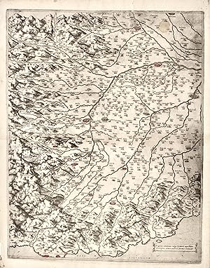
Regionis subalpinae vulgo Piemonte appellatae discriptio, aeneis nostris formis excussa.
Verlag: Roma, 1560
Anbieter: libreria antiquaria perini Sas di Perini, Verona, VR, Italien
Bewertung:
Kunst / Grafik / Poster
Acquaforte e bulino, mm 510x405. Stato I/I. Importante carta geografica del Piemonte, impressa su singolo foglio reale, stampata a Roma dal Lafrery nel 1560 circa. L'attribuzione alla paternit? dell'opera si deve a Roberto Almagi?, seguito poi da Tooley. Sebbene non sia certo quale sia la prima carta a stampa della regione (Perini sostiene che questa derivi da un anonima carta veneta del 1553), questo lavoro puÚ essere definito come il primo vero rilievo della sola regione, con particolare attenzione per la zona alpina. Orientata con il nord in alto, la carta presenta una toponomastica particolarmente ricca. Della carta esiste un secondo stato con la data 1564 e l'indirizzo di Lafreri aggiunti, un terzo pubblicato da Pietro de Nobili, con l'aggiunta del suo indirizzo ed un quarto ed ultimo con l'imprint abraso grossolanamente. Aliprandi (2005), p. 79; Cartografia rara, 102; L'Italia e le sue regioni nella bottega dell'incisore, a cura di Vladimiro Valerio, pag. 34, tav. 8; Almagi? XVIII; Tooley 446; Perini p. 43; Bifolco-Ronca (2014), 49; Bifolco-Ronca, Cartografia e topografia italiana del XVI secolo, 950. Nr.cat: 8305.
-
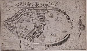
Beautiful engraved view of the Franco-Ottoman Siege of Nice in 1543 ( 2/8 x 15 6/8 inches to the neat line, mounted into 4 separate marginal sheets at an early date 19 4/8 x 22 6/8 inches). An exceptionally fine and early perspective view of Nice as it was besieged by a Franco-Ottoman force in 1543. The Mediterranean is shown filled with a flotilla of small ships propelled by single sails and oars; the fortress and citadel of Nice fly the Christian flag of the Holy Roman Emperor Charles V, while fiercely armed troops rally in the Ottoman held church of S. Croce to the left and Villa Fraca to the right, under the command of Heyreddin Barbarossa. The Siege of Nice was a critical part of the Italian War of 1542-1546. Francis I and Suleiman the Magnificent created a Franco-Ottoman alliance against the then Holy Roman Emperor Charles V, and Henry VIII of England. At that time of the siege Nice was under the control of Charles III, Duke of Savoy. Created by one of the Lafreri school of engravers, who were producing maps and views during "ONE OF THE MOST INTERESTING AND BRILLIANT PERIODS IN THE HISTORY OF CARTOGRAPHY" (Tooley). Between 1540 and 1570 Italy was the center of cartography, and Antonio Lafreri, a major map seller and publisher in Rome was one of the first to issue an atlas of assorted maps with an engraved title page. Tooley (1939) 419. Kate Hunter May 2013.
-

Hybernia Nunc Irlant.
Verlag: Ioanes Orlandi,, Rome,, 1602
Anbieter: Daniel Crouch Rare Books Ltd, London, Vereinigtes Königreich
Verbandsmitglied: ABA ILAB PBFA
Bewertung:
Karte
Rare Lafreri School map of Ireland Engraved map. A rare early map of Ireland published by the Lafreri School. The island's shape is remarkably accurate compared to contemporary maps. The territory is scattered with mountains, forests, lakes and rivers, as well as major towns, and includes names of the provinces. A vessel navigates the North Atlantic Ocean and two sea monsters seize the seas. The Connaught bulge is more in evidence in this map that it was to be for another 100 years. A curious detail is 'Purgesoriu S. Patricij', or St Patrick's Purgatory, in a lake in the island's north. According to legend, the site dates from the fifth century, when God showed Saint Patrick a cave on Station Island, on Lough Derg, that was an entrance to Purgatory. The site was mentioned in texts as early as 1185 and became an important pilgrimage site in Medieval times. It appeared on maps as early as the fifteenth century and it was the only Irish site noted on Martin Behaim's famous globe of 1482. The geography of the map follows Bolognino Zaltieri's 1565 map of Ireland. The author of the map was most likely Antonio Lafreri, the leading map publisher of the time. Born France in 1512, he settled in Rome in 1540 and soon opened an engraving and print selling business, which became the largest and most prolific one in Rome. The activity of Claudio Duchetti, Antonio Lafreri's nephew, flourished from about 1570 to about 1585. Among his earliest maps were a series of maps of the Mediterranean islands, including Minorca, Majorca and Cyprus. His stock, which included plates published by Lafreri, passed to Giovanni Orlandi who reprinted many of them dated 1602. Rare. The map rarely appears on the market. Bifolco 278, state 3; Bonar Law P 10iii; Tooley, Maps in Italian Atlases, 319.
-
![Bild des Verkäufers für La descrittione della prima parte dell'Asia. [and] Il disegno della seconda parte dell'Asia. zum Verkauf von Daniel Crouch Rare Books Ltd](https://pictures.abebooks.com/inventory/md/md30752769346.jpg)
La descrittione della prima parte dell'Asia. [and] Il disegno della seconda parte dell'Asia.
Verlag: 1561]., [Rome and Venice respectively,, 1561
Anbieter: Daniel Crouch Rare Books Ltd, London, Vereinigtes Königreich
Verbandsmitglied: ABA ILAB PBFA
Bewertung:
Karte
The most important maps of the Middle East and Arabia published in the sixteenth century Pair of engraved maps, each on two sheets joined, watermark of ladder in shield under six-pointed star (Woodward 253), to all four sheets. Fine examples of the most influential sixteenth century maps of Central Asia and the Middle East, by Giacomo Gastaldi, the greatest cartographer of his era. Not only are these works the most accurate depiction of the area to date, but would go on to dominate the European view of the area for the rest of the sixteenth century. Giacomo Gastaldi (c1500-1567), originally from Piedmont, established himself as a cartographer in Venice, where he was given the notable title of 'Cosmographer to the Republic'. He was a prolific mapmaker, with a body of work numbering at least 109 pieces, including contributions to the 1548 Venice edition of Ptolemy's 'Geogra a', and Ramusio's 'Navigationi et viaggi'. Gastaldi's maps of Asia are considered amongst the most significant representations of the continent, as the first pieces of cartography to name, and even show, many of the areas depicted. They were also responsible for numerous features which would later become standardised, such as the ovalized Caspian Sea. Originating from Venice, the maps are also a reflection of the Republic's dominance of early exploration, particularly in Asia. e city's crucial position allowed for Western contact with the East, although this relationship was becoming progressively threatened by the expansion of the Ottoman Empire. The first part of Asia, here in its first state by Lafreri, is based on Gastaldi's map of 1559. Although Lafreri had permission to print and sell Gastaldi's original maps, this map was made from a re-engraving by Jacopo Bos, perhaps because of damage to the original plates. Bos' work is very similar to that of Gastaldi's own engraver, Fabio Licinio, with stylistic differences in the waters and ships revealing the new engraver's hand. It has been suggested that Bos engraved this edition for the Roman publisher Michele Tramezzino, and that only later did Lafreri acquire the publishing rights (Witcombe). The second part is here in its first state and was engraved by Licinio. The upper part repeats some areas of the previous map, however the two were intended to form one, as shown by the identical scale bars and projection. Together the two parts extend from southern Siberia to the Indian Ocean, encompassing huge swathes of the continent. ey cover Turkey, the Middle East, the Black and Caspian Seas, the Eastern Mediterranean with Cyprus, the stream of the Nile and the whole of the Arabian Peninsula, with part of Western India and the Maldives. The coastal and island names, as noted by Nordenskjöld, are taken from portolans and from voyages of Spanish and Portuguese exploration. Some interior names are taken directly from Marco Polo and almost identical in orthography to those used by Ramusio. The abundance of toponyms suggests further sources, which Gastaldi may have accessed in the large library of the Fugger family. Markus Fugger, a prominent businessman and politician, was among the cartographer's acquaintances, and the second part of Asia is dedicated solely to him. Importantly, Gastaldi's maps of Asia provided the basis for those later published by Ortelius, De Jode and Mercator. Bifolco records 33 examples of the first map held in institutions, and 42 of the second, but both are rare on the market. We have been able to trace only four examples of the first, and seven of the second, appearing at auction in the last 50 years. Bifolco 68 state 1, and 71 state 1; Nordenskjöld, pp. 396-406, The Geographical Journal vol. 13, April 1899; Schilder p.7, The Map Collector 17, December 1981; Suárez, The early mapping of Southeast Asia, pp.130-157, 1999; Tooley pp.20, 21; Witcombe 234, 2008. 495 by 795mm. (19.5 by 31.25 inches). 450 by 780mm (17.75 by 30.75 inches).