Gesamtpreis (1 Artikel Artikel):
Versandziel:

BLACKIE W G (95 Ergebnisse)
Direkt zu den wichtigsten Suchergebnissen
Produktart
- Alle Produktarten
- Bücher (77)
- Magazine & Zeitschriften
- Comics
- Noten
- Kunst, Grafik & Poster
- Fotografien
- Karten (18)
-
Manuskripte &
Papierantiquitäten
Zustand
Einband
Weitere Eigenschaften
Gratisversand
Land des Verkäufers
Verkäuferbewertung
-

State of Scots Law
Verlag: LexisNexis, 2001
ISBN 10: 0406944520ISBN 13: 9780406944528
Anbieter: Better World Books Ltd, Dunfermline, Vereinigtes Königreich
Bewertung:

Buch
Zustand: Good. Ships from the UK. Used book that is in clean, average condition without any missing pages.
-

Zustand: Good. This is an ex-library book and may have the usual library/used-book markings inside.This book has hardback covers. In good all round condition. No dust jacket. Please note the Image in this listing is a stock photo and may not match the covers of the actual item,400grams, ISBN:
-
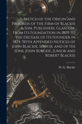
Paperback or Softback. Zustand: New. Sketch of the Origin and Progress of the Firm of Blackie & Son, Publishers, Glasgow, From Its Foundation in 1809 to the Decease of Its Founder in 1874 0.61. Book.
Mehr Angebote von anderen Verkäufern bei AbeBooks
Neu ab EUR 20,74
-

A Scottish Student In Leipzig: Being Letters Of W. G. Blackie, His Father And His Brothers In The Years 1839-40.
Verlag: Blackie, 1932
Anbieter: World of Rare Books, Goring-by-Sea, SXW, Vereinigtes Königreich
Bewertung:
Zustand: Good. 1932. 178 pages. No dust jacket. Blue cloth with gilt lettering. Pages are moderately tanned and thumbed at the edges, with moderate foxing. Binding has remained firm. Boards are a little rub worn, slight shelf wear to corners, spine and edges. Corners are a little bumped. Spine ends are mildly crushed. Tanning to spine and edges. Boards are bowed. Book has a forward lean.
-

On Geography and Ethnology: What these embrace. This is an original article from the Proceedings of the Glasgow Philosophical Society, 1884.
Verlag: Glasgow Philosophical Society, Glasgow, 1884
Erstausgabe
Disbound. Zustand: Very Good. First Edition. 8 pages. The Royal Philosophical Society of Glasgow is a learned society established in 1802, for the improvement of the Arts and Sciences in the city of Glasgow, Scotland. Note; this is an original article separated from the volume, not a reprint or copy. Size: 13 x 21 cms. Quantity Available: 1. Category: Glasgow Philosophical Society; Inventory No: 422757. Cosmo Books : 26 years selling on ABE; 26 years of taking care of customers on ABE; A seller you can rely on.
-
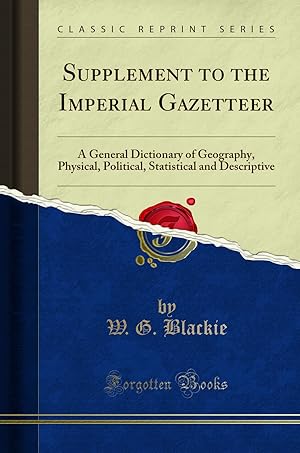
Supplement to the Imperial Gazetteer (Classic Reprint)
Verlag: Forgotten Books, 2018
ISBN 10: 1332202233ISBN 13: 9781332202232
Buch Print-on-Demand
Paperback. Zustand: New. Print on Demand. Excerpt from Supplement to the Imperial Gazetteer. About the Publisher, Forgotten Books publishes hundreds of thousands of rare and classic books. This book is a reproduction of an important historical work. Forgotten Books uses state-of-the-art technology to digitally reconstruct the work, preserving the original format whilst repairing imperfections present in the aged copy. In rare cases, an imperfection in the original, such as a blemish or missing page, may be replicated in our edition. We do, however, repair the vast majority of imperfections successfully; any imperfections that remain are intentionally left to preserve the state of such historical works. This text has been digitally restored from a historical edition. Some errors may persist, however we consider it worth publishing due to the work's historical value. The digital edition of all books may be viewed on our website before purchase. print-on-demand item.
Mehr Angebote von anderen Verkäufern bei AbeBooks
Neu ab EUR 20,77
-

The Imperial Gazetteer Vol. II
Verlag: Blackie & Son Limited, 1860
Anbieter: World of Rare Books, Goring-by-Sea, SXW, Vereinigtes Königreich
Bewertung:
Zustand: Good. 1860. No Edition Stated. Unpaginated. Vol. II. Full leather binding with faded lettering. B&W illustrations throughout. Notable foxing and tanning to endpapers and page edges. Clean pages. Front hinge cracked but binding remains firm. Moderate wear and bumping to spine, board edges and corners, with large splits to spine and joint ends. Spine title plates presumed missing. Notable scuffing, staining and marking to boards.
-
The Imperial Gazetteer Vol.IV
Verlag: Blackie & Son, 1860
Anbieter: World of Rare Books, Goring-by-Sea, SXW, Vereinigtes Königreich
Bewertung:
Zustand: Fair. 1860. No Edition Remarks. Unpaginated. Fully bound in decorative leather. Volume IV, misprint to title page says volume I. Black and white illustrations throughout. Moderate foxing and tanning to pages. More prominent to text block edges. Hinges are moderately cracked causing boards to be loose. Binding otherwise remains firm. Boards have minor corner bumping and edgewear with mild rubbing, tanning and scuffing overall. Spine has heavier tanning with prominent splitting, fraying and crushing to ends and joints; some of the leather is coming away form spine. Book has a slight forward lean.
-
Russian Acquisitions in Manchooria and an account of the physical aspects of the river Amoor as a pathway for commerce. This is an original article from the Proceedings of the Glasgow Philosophical Society, 1858.
Verlag: Glasgow Philosophical Society, Glasgow, 1858
Erstausgabe
Disbound. Zustand: Very Good. First Edition. 16 pages. The Royal Philosophical Society of Glasgow is a learned society established in 1802, for the improvement of the Arts and Sciences in the city of Glasgow, Scotland. Note; this is an original article separated from the volume, not a reprint or copy. Size: 13 x 21 cms. Quantity Available: 1. Category: Glasgow Philosophical Society; Inventory No: 422704. Cosmo Books : 26 years selling on ABE; 26 years of taking care of customers on ABE; A seller you can rely on.
-

Poetical Recreation
Verlag: HardPress Publishing, 2021
ISBN 10: 0371747732ISBN 13: 9780371747735
Buch
Paperback. Zustand: New. New copy - Usually dispatched within 4 working days.
Mehr Angebote von anderen Verkäufern bei AbeBooks
Neu ab EUR 20,63
-
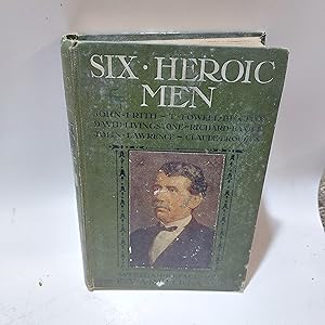
Six Heroic Men John Frith, T Fowell Buxton, David Livingstone, Richard Baxter, John Lawrence and Claude Brousson
Verlag: The Religious Tract Society
Anbieter: Cambridge Rare Books, Cambridge, GLOUC, Vereinigtes Königreich
Bewertung:
Hardcover. Zustand: GOOD. Undated. The Religious Tract Society. Hardcover. GOOD Gilt and white titles, green boards with pasted down image on the front. Pages are generally clean with some having a few marks. Fep missing. Edgewear. 7x5.
-
The Imperial Gazetteer Vol I
Verlag: Blackie & Son, 1860
Anbieter: World of Rare Books, Goring-by-Sea, SXW, Vereinigtes Königreich
Bewertung:
Zustand: Fair. 1860. No Edition Stated. 664 pages. Vol I. Full leather binding with faded lettering. B&W illustrations throughout. Clean pages. Notable foxing and tanning to endpapers and page edges. Front hinge cracked but binding remains firm. Moderate wear and bumping to spine, board edges and corners, with splitting to joint ends. Minor loss to spine head. Spine title plates presumed to be missing. Notable scuffing, staining and marking to boards, with tanning to spine and board edges.
-
The Imperial Gazetteer Vol.III
Verlag: Blackie & Son, 1860
Anbieter: World of Rare Books, Goring-by-Sea, SXW, Vereinigtes Königreich
Bewertung:
Zustand: Fair. 1860. No Edition Remarks. 680 pages. Fully bound in decorative leather. Vol. III, title page misprint says Volume II. Black and white illustrations throughout. Book has a slight smoky odour. Light foxing and moderate tanning to pages. More prominent to text block edges. Hinges are moderately cracked causing boards to be loose. Binding otherwise remains firm. Boards have moderate corner bumping and edge-wear with visible tanning, rubbing and scuffing overall. Spine has minor tanning with visible chipping, splitting and crushing to joints and ends. Book has a slight forward lean.
-
![Bild des Verkäufers für Sketch of the origin and progress of the firm of Blackie & Son, Publishers, Glasgow, from its foundation in 1809 to the decease of its founder in 1874. With appended notices of John Blackie, Senior, and of his sons, John Blackie, Junior and Robert Blackie (1897) [LeatherBound] zum Verkauf von True World of Books](https://pictures.abebooks.com/inventory/md/md31657382421.jpg)
Sketch of the origin and progress of the firm of Blackie & Son, Publishers, Glasgow, from its foundation in 1809 to the decease of its founder in 1874. With appended notices of John Blackie, Senior, and of his sons, John Blackie, Junior and Robert Blackie (1897) [LeatherBound]
Erscheinungsdatum: 2023
Buch Print-on-Demand
LeatherBound. Zustand: New. LeatherBound edition. Condition: New. Reprinted from 1897 edition. Leather Binding on Spine and Corners with Golden leaf printing on spine. Bound in genuine leather with Satin ribbon page markers and Spine with raised gilt bands. A perfect gift for your loved ones. NO changes have been made to the original text. This is NOT a retyped or an ocr'd reprint. Illustrations, Index, if any, are included in black and white. Each page is checked manually before printing. As this print on demand book is reprinted from a very old book, there could be some missing or flawed pages, but we always try to make the book as complete as possible. Fold-outs, if any, are not part of the book. If the original book was published in multiple volumes then this reprint is of only one volume, not the whole set. Sewing binding for longer life, where the book block is actually sewn (smythe sewn/section sewn) with thread before binding which results in a more durable type of binding. Pages: 194 Blackie, W. G. (Walter Graham), 1816-1906.
-
![Bild des Verkäufers für Sketch of the origin and progress of the firm of Blackie & Son, publishers, Glasgow, from its foundation in 1809 to the decease of its founder in 1874 / with appended notices of John Blackie, senior, and of his sons John Blackie, junior, and Robert Blackie (1897) [Leatherbound] zum Verkauf von S N Books World](https://pictures.abebooks.com/inventory/md/md30639444236.jpg)
Sketch of the origin and progress of the firm of Blackie & Son, publishers, Glasgow, from its foundation in 1809 to the decease of its founder in 1874 / with appended notices of John Blackie, senior, and of his sons John Blackie, junior, and Robert Blackie (1897) [Leatherbound]
Erscheinungsdatum: 2022
Buch Print-on-Demand
Leatherbound. Zustand: NEW. Leatherbound edition. Condition: New. Leather Binding on Spine and Corners with Golden leaf printing on spine. Bound in genuine leather with Satin ribbon page markers and Spine with raised gilt bands. A perfect gift for your loved ones. Reprinted from 1897 edition. NO changes have been made to the original text. This is NOT a retyped or an ocr'd reprint. Illustrations, Index, if any, are included in black and white. Each page is checked manually before printing. As this print on demand book is reprinted from a very old book, there could be some missing or flawed pages, but we always try to make the book as complete as possible. Fold-outs, if any, are not part of the book. If the original book was published in multiple volumes then this reprint is of only one volume, not the whole set. IF YOU WISH TO ORDER PARTICULAR VOLUME OR ALL THE VOLUMES YOU CAN CONTACT US. Resized as per current standards. Sewing binding for longer life, where the book block is actually sewn (smythe sewn/section sewn) with thread before binding which results in a more durable type of binding. Pages: 196 Language: English Pages: 196.
-
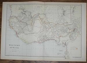
1884 Blackie's Map of Western Africa
Verlag: Blackie & Son, London, Glasgow, Edinburgh and Dublin, 1884
Karte
Softcover. Zustand: Very Good. Zustand des Schutzumschlags: No Dust Jacket. Drawn and Engraved by J. Bartholomew (illustrator). Early Edition. Disbound map from the 1884 "Comprehensive Atlas & Geography of the World: Comprising an Extensive Series of Maps, a Description, Physical and Political, of all the Countries of the Earth; a Pronouncing Vocabulary of Geographical Names, and a Copious Index of Geographical Positions. Compiled and Engraved from the Most Authentic Sources, Under the Supervision of W. G. Blackie, PhD., F.S.A.Scot." Sheet number covers Single sheet with horizontal centre fold. Sheet is clean but slightly darkened at the edges. Map is drawn to a given scale with latitude and longitude lines, map is extensively labeled. Pastel shades have been used to denote countries and slightly darker shades have been used to denote boarders. Black and white engraved hatching shows landscape features. Size: 38x56cm. Item Type: Map. No dust jacket, as published. Single sheet map/chart which is suitable for framing. Illustrator: Drawn and Engraved by J. Bartholomew. Quantity Available: 1. Shipped Weight: under 1 kg. Pictures of this item not already displayed here available upon request. Inventory No: 45117104040. For International tracked shipping please select the Priority shipping service.
-
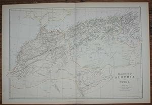
1884 Blackie's Map of Marocco, Algeria and Tunis
Verlag: Blackie & Son, London, Glasgow, Edinburgh and Dublin, 1884
Karte
Softcover. Zustand: Very Good. Zustand des Schutzumschlags: No Dust Jacket. Drawn and Engraved by J. Bartholomew (illustrator). Early Edition. Disbound map from the 1884 "Comprehensive Atlas & Geography of the World: Comprising an Extensive Series of Maps, a Description, Physical and Political, of all the Countries of the Earth; a Pronouncing Vocabulary of Geographical Names, and a Copious Index of Geographical Positions. Compiled and Engraved from the Most Authentic Sources, Under the Supervision of W. G. Blackie, PhD., F.S.A.Scot." Sheet number covers Single sheet with horizontal centre fold. Sheet is clean but slightly darkened at the edges. Map is drawn to a given scale with latitude and longitude lines, map is extensively labeled. Pastel shades have been used to denote countries and slightly darker shades have been used to denote boarders. Black and white engraved hatching shows landscape features. Size: 38x56cm. Item Type: Map. No dust jacket, as published. Single sheet map/chart which is suitable for framing. Illustrator: Drawn and Engraved by J. Bartholomew. Quantity Available: 1. Shipped Weight: under 1 kg. Pictures of this item not already displayed here available upon request. Inventory No: 45117104041. For International tracked shipping please select the Priority shipping service.
-
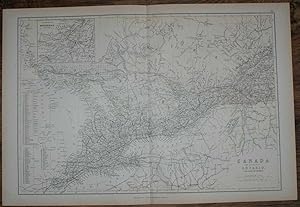
1884 Blackie's Map of Canada - The Province of Ontario and part of Quebec
Verlag: Blackie & Son, London, Glasgow, Edinburgh and Dublin, 1884
Karte
Softcover. Zustand: Very Good. Zustand des Schutzumschlags: No Dust Jacket. Drawn and Engraved by J. Bartholomew (illustrator). Early Edition. Disbound map from the 1884 "Comprehensive Atlas & Geography of the World: Comprising an Extensive Series of Maps, a Description, Physical and Political, of all the Countries of the Earth; a Pronouncing Vocabulary of Geographical Names, and a Copious Index of Geographical Positions. Compiled and Engraved from the Most Authentic Sources, Under the Supervision of W. G. Blackie, PhD., F.S.A.Scot." Sheet number covers Single sheet with horizontal centre fold. Sheet is clean but slightly darkened at the edges. Map is drawn to a given scale with latitude and longitude lines, map is extensively labeled. Pastel shades have been used to denote countries and slightly darker shades have been used to denote boarders. Black and white engraved hatching shows landscape features. Size: 38x56cm. Item Type: Map. No dust jacket, as published. Single sheet map/chart which is suitable for framing. Illustrator: Drawn and Engraved by J. Bartholomew. Quantity Available: 1. Shipped Weight: under 1 kg. Pictures of this item not already displayed here available upon request. Inventory No: 45117104036. For International tracked shipping please select the Priority shipping service.
-
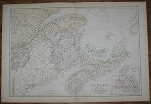
1884 Blackie's Map of Canada - The Provinces of Quebec, Nova Scotia, New Brunswick, Prince Edward Island and Newfoundland
Verlag: Blackie & Son, London, Glasgow, Edinburgh and Dublin, 1884
Karte
Softcover. Zustand: Very Good. Zustand des Schutzumschlags: No Dust Jacket. Drawn and Engraved by J. Bartholomew (illustrator). Early Edition. Disbound map from the 1884 "Comprehensive Atlas & Geography of the World: Comprising an Extensive Series of Maps, a Description, Physical and Political, of all the Countries of the Earth; a Pronouncing Vocabulary of Geographical Names, and a Copious Index of Geographical Positions. Compiled and Engraved from the Most Authentic Sources, Under the Supervision of W. G. Blackie, PhD., F.S.A.Scot." Single sheet with vertical centre fold. Sheet is clean but slightly darkened at the edges. Map is drawn to a given scale with latitude and longitude lines, map is extensively labeled. Pastel shades have been used to denote countries and slightly darker shades have been used to denote boarders. Black and white engraved hatching shows landscape features. Size: 38x56cm. Item Type: Map. No dust jacket, as published. Single sheet map/chart which is suitable for framing. Illustrator: Drawn and Engraved by J. Bartholomew. Quantity Available: 1. Shipped Weight: under 1 kg. Pictures of this item not already displayed here available upon request. Inventory No: 45117104037. For International tracked shipping please select the Priority shipping service.
-
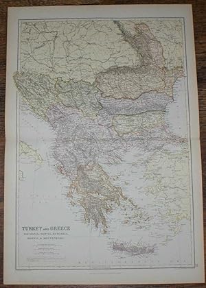
1884 Blackie's Map of Turkey, Greece, Roumania, Servia, Bulgaria, Bosnia & Montenegro
Verlag: Blackie & Son, London, Glasgow, Edinburgh and Dublin, 1884
Karte
Softcover. Zustand: Very Good. Zustand des Schutzumschlags: No Dust Jacket. Drawn and Engraved by J. Bartholomew (illustrator). Early Edition. Disbound map from the 1884 "Comprehensive Atlas & Geography of the World: Comprising an Extensive Series of Maps, a Description, Physical and Political, of all the Countries of the Earth; a Pronouncing Vocabulary of Geographical Names, and a Copious Index of Geographical Positions. Compiled and Engraved from the Most Authentic Sources, Under the Supervision of W. G. Blackie, PhD., F.S.A.Scot." Sheet number covers Single sheet with horizontal centre fold. Sheet is clean but slightly darkened at the edges. Map is drawn to a given scale with latitude and longitude lines, map is extensively labeled. Pastel shades have been used to denote countries and slightly darker shades have been used to denote boarders. Black and white engraved hatching shows landscape features. Size: 56x38cm. Item Type: Map. No dust jacket, as published. Single sheet map/chart which is suitable for framing. Illustrator: Drawn and Engraved by J. Bartholomew. Quantity Available: 1. Shipped Weight: under 1 kg. Pictures of this item not already displayed here available upon request. Inventory No: 45117104007. For International tracked shipping please select the Priority shipping service.
-
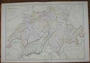
1884 Blackie's Map of Switzerland
Verlag: Blackie & Son, London, Glasgow, Edinburgh and Dublin, 1884
Karte
Softcover. Zustand: Very Good. Zustand des Schutzumschlags: No Dust Jacket. Drawn and Engraved by J. Bartholomew (illustrator). Early Edition. Disbound map from the 1884 "Comprehensive Atlas & Geography of the World: Comprising an Extensive Series of Maps, a Description, Physical and Political, of all the Countries of the Earth; a Pronouncing Vocabulary of Geographical Names, and a Copious Index of Geographical Positions. Compiled and Engraved from the Most Authentic Sources, Under the Supervision of W. G. Blackie, PhD., F.S.A.Scot." Sheet number covers Single sheet with horizontal centre fold. Sheet is clean but slightly darkened at the edges. Map is drawn to a given scale with latitude and longitude lines, map is extensively labeled. Pastel shades have been used to denote countries and slightly darker shades have been used to denote boarders. Black and white engraved hatching shows landscape features. Size: 38x56cm. Item Type: Map. No dust jacket, as published. Single sheet map/chart which is suitable for framing. Illustrator: Drawn and Engraved by J. Bartholomew. Quantity Available: 1. Shipped Weight: under 1 kg. Pictures of this item not already displayed here available upon request. Inventory No: 45117104018. For International tracked shipping please select the Priority shipping service.
-
1884 Blackie's Map of Central Europe, showing the Principal Railways and the Political Boundaries
Verlag: Blackie & Son, London, Glasgow, Edinburgh and Dublin, 1884
Karte
Softcover. Zustand: Very Good. Zustand des Schutzumschlags: No Dust Jacket. Drawn and Engraved by J. Bartholomew (illustrator). Early Edition. Disbound map from the 1884 "Comprehensive Atlas & Geography of the World: Comprising an Extensive Series of Maps, a Description, Physical and Political, of all the Countries of the Earth; a Pronouncing Vocabulary of Geographical Names, and a Copious Index of Geographical Positions. Compiled and Engraved from the Most Authentic Sources, Under the Supervision of W. G. Blackie, PhD., F.S.A.Scot." Sheet number covers Single sheet with horizontal centre fold. Sheet is clean but slightly darkened at the edges. Map is drawn to a given scale with latitude and longitude lines, map is extensively labeled. Pastel shades have been used to denote countries and slightly darker shades have been used to denote boarders. Black and white engraved hatching shows landscape features. Size: 38x56cm. Item Type: Map. No dust jacket, as published. Single sheet map/chart which is suitable for framing. Illustrator: Drawn and Engraved by J. Bartholomew. Quantity Available: 1. Shipped Weight: under 1 kg. Pictures of this item not already displayed here available upon request. Inventory No: 45117104021. For International tracked shipping please select the Priority shipping service.
-
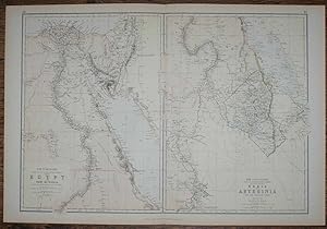
1884 Blackie's Maps of The Nile Valley - Egypt, Nubia & Abyssinia
Verlag: Blackie & Son, London, Glasgow, Edinburgh and Dublin, 1884
Karte
Softcover. Zustand: Very Good. Zustand des Schutzumschlags: No Dust Jacket. Drawn and Engraved by J. Bartholomew (illustrator). Early Edition. Disbound map from the 1884 "Comprehensive Atlas & Geography of the World: Comprising an Extensive Series of Maps, a Description, Physical and Political, of all the Countries of the Earth; a Pronouncing Vocabulary of Geographical Names, and a Copious Index of Geographical Positions. Compiled and Engraved from the Most Authentic Sources, Under the Supervision of W. G. Blackie, PhD., F.S.A.Scot." Sheet number covers Single sheet with horizontal centre fold. Sheet is clean but slightly darkened at the edges. Map is drawn to a given scale with latitude and longitude lines, map is extensively labeled. Pastel shades have been used to denote countries and slightly darker shades have been used to denote boarders. Black and white engraved hatching shows landscape features. Size: 38x56cm. Item Type: Map. No dust jacket, as published. Single sheet map/chart which is suitable for framing. Illustrator: Drawn and Engraved by J. Bartholomew. Quantity Available: 1. Shipped Weight: under 1 kg. Pictures of this item not already displayed here available upon request. Inventory No: 45117104022. For International tracked shipping please select the Priority shipping service.
-
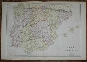
1884 Blackie's Map of Spain and Portugal
Verlag: Blackie & Son, London, Glasgow, Edinburgh and Dublin, 1884
Karte
Softcover. Zustand: Very Good. Zustand des Schutzumschlags: No Dust Jacket. Drawn and Engraved by J. Bartholomew (illustrator). Early Edition. Disbound map from the 1884 "Comprehensive Atlas & Geography of the World: Comprising an Extensive Series of Maps, a Description, Physical and Political, of all the Countries of the Earth; a Pronouncing Vocabulary of Geographical Names, and a Copious Index of Geographical Positions. Compiled and Engraved from the Most Authentic Sources, Under the Supervision of W. G. Blackie, PhD., F.S.A.Scot." Sheet number covers Single sheet with horizontal centre fold. Sheet is clean but slightly darkened at the edges. Map is drawn to a given scale with latitude and longitude lines, map is extensively labeled. Pastel shades have been used to denote countries and slightly darker shades have been used to denote boarders. Black and white engraved hatching shows landscape features. Size: 38x56cm. Item Type: Map. No dust jacket, as published. Single sheet map/chart which is suitable for framing. Illustrator: Drawn and Engraved by J. Bartholomew. Quantity Available: 1. Shipped Weight: under 1 kg. Pictures of this item not already displayed here available upon request. Inventory No: 45117104016. For International tracked shipping please select the Priority shipping service.
-
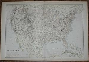
1884 Blackie's Map of The United States of North America
Verlag: Blackie & Son, London, Glasgow, Edinburgh and Dublin, 1884
Karte
Softcover. Zustand: Very Good. Zustand des Schutzumschlags: No Dust Jacket. Drawn and Engraved by J. Bartholomew (illustrator). Early Edition. Disbound map from the 1884 "Comprehensive Atlas & Geography of the World: Comprising an Extensive Series of Maps, a Description, Physical and Political, of all the Countries of the Earth; a Pronouncing Vocabulary of Geographical Names, and a Copious Index of Geographical Positions. Compiled and Engraved from the Most Authentic Sources, Under the Supervision of W. G. Blackie, PhD., F.S.A.Scot." Sheet number covers Single sheet with horizontal centre fold. Sheet is clean but slightly darkened at the edges. Map is drawn to a given scale with latitude and longitude lines, map is extensively labeled. Pastel shades have been used to denote countries and slightly darker shades have been used to denote boarders. Black and white engraved hatching shows landscape features. Size: 38x56cm. Item Type: Map. No dust jacket, as published. Single sheet map/chart which is suitable for framing. Illustrator: Drawn and Engraved by J. Bartholomew. Quantity Available: 1. Shipped Weight: under 1 kg. Pictures of this item not already displayed here available upon request. Inventory No: 45117104035. For International tracked shipping please select the Priority shipping service.
-
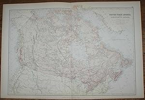
1884 Blackie's Map of British North America - The Dominion of Canada
Verlag: Blackie & Son, London, Glasgow, Edinburgh and Dublin, 1884
Karte
Softcover. Zustand: Very Good. Zustand des Schutzumschlags: No Dust Jacket. Drawn and Engraved by J. Bartholomew (illustrator). Early Edition. Disbound map from the 1884 "Comprehensive Atlas & Geography of the World: Comprising an Extensive Series of Maps, a Description, Physical and Political, of all the Countries of the Earth; a Pronouncing Vocabulary of Geographical Names, and a Copious Index of Geographical Positions. Compiled and Engraved from the Most Authentic Sources, Under the Supervision of W. G. Blackie, PhD., F.S.A.Scot." Sheet number covers Single sheet with horizontal centre fold. Sheet is clean but slightly darkened at the edges. Map is drawn to a given scale with latitude and longitude lines, map is extensively labeled. Pastel shades have been used to denote countries and slightly darker shades have been used to denote boarders. Black and white engraved hatching shows landscape features. Size: 38x56cm. Item Type: Map. No dust jacket, as published. Single sheet map/chart which is suitable for framing. Illustrator: Drawn and Engraved by J. Bartholomew. Quantity Available: 1. Shipped Weight: under 1 kg. Pictures of this item not already displayed here available upon request. Inventory No: 45117104038. For International tracked shipping please select the Priority shipping service.
-
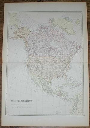
1884 Blackie's Map of North America
Verlag: Blackie & Son, London, Glasgow, Edinburgh and Dublin, 1884
Karte
Softcover. Zustand: Very Good. Zustand des Schutzumschlags: No Dust Jacket. Drawn and Engraved by J. Bartholomew (illustrator). Early Edition. Disbound map from the 1884 "Comprehensive Atlas & Geography of the World: Comprising an Extensive Series of Maps, a Description, Physical and Political, of all the Countries of the Earth; a Pronouncing Vocabulary of Geographical Names, and a Copious Index of Geographical Positions. Compiled and Engraved from the Most Authentic Sources, Under the Supervision of W. G. Blackie, PhD., F.S.A.Scot." Sheet number covers Single sheet with horizontal centre fold. Sheet is clean but slightly darkened at the edges. Map is drawn to a given scale with latitude and longitude lines, map is extensively labeled. Pastel shades have been used to denote countries and slightly darker shades have been used to denote boarders. Black and white engraved hatching shows landscape features. Size: 56x38cm. Item Type: Map. No dust jacket, as published. Single sheet map/chart which is suitable for framing. Illustrator: Drawn and Engraved by J. Bartholomew. Quantity Available: 1. Shipped Weight: under 1 kg. Pictures of this item not already displayed here available upon request. Inventory No: 45117104005. For International tracked shipping please select the Priority shipping service.
-
Softcover. Zustand: Very Good. Zustand des Schutzumschlags: No Dust Jacket. Drawn and Engraved by J. Bartholomew (illustrator). Early Edition. Disbound map from the 1884 "Comprehensive Atlas & Geography of the World: Comprising an Extensive Series of Maps, a Description, Physical and Political, of all the Countries of the Earth; a Pronouncing Vocabulary of Geographical Names, and a Copious Index of Geographical Positions. Compiled and Engraved from the Most Authentic Sources, Under the Supervision of W. G. Blackie, PhD., F.S.A.Scot." Sheet number covers Single sheet with horizontal centre fold. Sheet is clean but slightly darkened at the edges. Map is drawn to a given scale with latitude and longitude lines, map is extensively labeled. Pastel shades have been used to denote countries and slightly darker shades have been used to denote boarders. Black and white engraved hatching shows landscape features. Size: 38x56cm. Item Type: Map. No dust jacket, as published. Single sheet map/chart which is suitable for framing. Illustrator: Drawn and Engraved by J. Bartholomew. Quantity Available: 1. Shipped Weight: under 1 kg. Pictures of this item not already displayed here available upon request. Inventory No: 45117104015. For International tracked shipping please select the Priority shipping service.
-
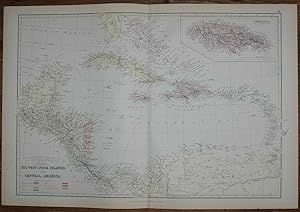
1884 Blackie's Map of The West India Islands and Central America
Verlag: Blackie & Son, London, Glasgow, Edinburgh and Dublin, 1884
Karte
Softcover. Zustand: Very Good. Zustand des Schutzumschlags: No Dust Jacket. Drawn and Engraved by J. Bartholomew (illustrator). Early Edition. Disbound map from the 1884 "Comprehensive Atlas & Geography of the World: Comprising an Extensive Series of Maps, a Description, Physical and Political, of all the Countries of the Earth; a Pronouncing Vocabulary of Geographical Names, and a Copious Index of Geographical Positions. Compiled and Engraved from the Most Authentic Sources, Under the Supervision of W. G. Blackie, PhD., F.S.A.Scot." Sheet number covers Single sheet with horizontal centre fold. Sheet is clean but slightly darkened at the edges. Map is drawn to a given scale with latitude and longitude lines, map is extensively labeled. Pastel shades have been used to denote countries and slightly darker shades have been used to denote boarders. Black and white engraved hatching shows landscape features. Size: 38x56cm. Item Type: Map. No dust jacket, as published. Single sheet map/chart which is suitable for framing. Illustrator: Drawn and Engraved by J. Bartholomew. Quantity Available: 1. Shipped Weight: under 1 kg. Pictures of this item not already displayed here available upon request. Inventory No: 45117104033. For International tracked shipping please select the Priority shipping service.
-
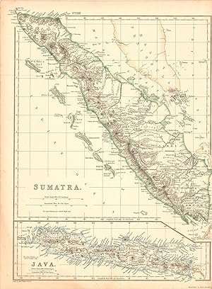
This map was made by W.G Blackie, Ph.D in 1860 for The Imperial Atlas of Modern Geography; An Extensive Series of Maps. Sumatra and Java are illustrated on this sheet. Original hand colored outlining and exquisite detailing make this a wonderful map for framing. This map measures 13.5 inches by 10 inches.