Gesamtpreis (1 Artikel Artikel):
Versandziel:

EN ROUTE (20 Ergebnisse)
Direkt zu den wichtigsten Suchergebnissen
Produktart
- Alle Produktarten
- Bücher (14)
- Magazine & Zeitschriften (2)
- Comics
- Noten (2)
- Kunst, Grafik & Poster (2)
- Fotografien
- Karten
-
Manuskripte &
Papierantiquitäten
Zustand
Einband
Weitere Eigenschaften
- Erstausgabe (1)
- Signiert (1)
- Schutzumschlag
- Angebotsfoto (12)
- Kein Print-on-Demand
Land des Verkäufers
Verkäuferbewertung
-
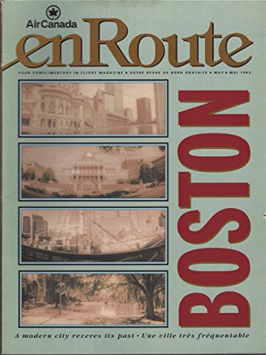
En Route Air Canada: Boston, Une Ville Tres Frequentee, a Modern City Reveres Its Past, a Boire = Delicieux Chichi, La Vie Video & Various (21)
Verlag: EN ROUTE AIR CANADA, 1993
ISBN 10: 2010199200ISBN 13: 9782010199202
Anbieter: Better World Books Ltd, Dunfermline, Vereinigtes Königreich
Bewertung:

Buch
Zustand: Good. Ships from the UK. Used book that is in clean, average condition without any missing pages.
Mehr Angebote von anderen Verkäufern bei AbeBooks
Gebraucht ab EUR 3,85
-

L'Illustration théâtrale N° 221 : Un drame sous Philippe II, suivi de Les Malefilatre, deux pičces de Georges de Porto-Riche. 12 octobre 1912.
Verlag: L'Illustration, 1912
Anbieter: Librairie Et Cćtera (et caetera) - Sophie Rosičre, Belin-Béliet, Frankreich
Bewertung:
Magazin / Zeitschrift
Couverture souple. En derničre page, publicité Michelin pour le numérotage des routes. (illustrator). Magazine / Périodique en français. En derničre page, publicité Michelin pour le numérotage des routes. Revue. 44 pages. Théâtre. Magazine / Périodique.
-
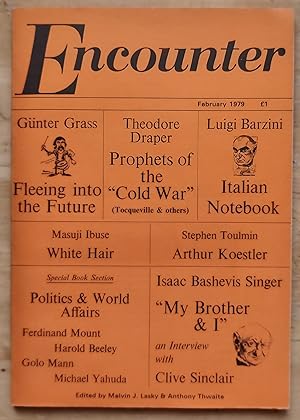
Encounter February 1979 / Gunter Grass " Fleeing Towards The Future: Reflections En Route In Asia" / Clive Sinclair "A Conversation With Isaac Bashevis Singer" / Luigi Barzini "Italian Notebook" / Theodore Draper "The Idea Of The 'Cold War' & Its Prophets" / Golo Mann / Seamus Haney "Elegy" / marina Warner / Ferdinand Mount / Helen von Ssachno "Alexander Zinoviev's Paradoxes" / Stephen Toulmin
Verlag: Encounter Ltd, 1979
Magazin / Zeitschrift
Soft cover. Zustand: Very Good. 96 pages. Gunter Grass " Fleeing Towards The Future: Reflections En Route In Asia" / Clive Sinclair "A Conversation With Isaac Bashevis Singer" / Luigi Barzini "Italian Notebook" / Theodore Draper "The Idea Of The 'Cold War' & Its Prophets" / Golo Mann / Seamus Haney "Elegy" / marina Warner / Ferdinand Mount / Helen von Ssachno "Alexander Zinoviev's Paradoxes" / Stephen Toulmin.
-
MARYE Arthur En route Chanson Joyeuse pour Piano Caen, Ed. Bonnaventure E. B. 21 ca1900 3 pages Trčs bon état 006585 Piano solo.
-
En Route Pour Chant et Piano Paroles de Ed. Guinand Musique de Charles RENÉ A Madame la Comtesse de Chambrun Paris, Mackar & Noël, Editeurs, M N 997 ca1890 5 pages 35 x 27 cm Trčs bon état 029578 Nouveau.
-

-
-
DVD. Zustand: Used: Very Good.
-

Paperback. Zustand: New.
-
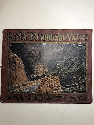
Rocky Mountain Views On the Rio Grande, "Scenic Line of the World". Consisting of Twenty-Three Colored Views from Recent Photographs
Verlag: Engraved, Printed and Published by The Smith-Brooks Printing Company, Denver, Colorado, 1917
Buch
Original Wraps. Zustand: Very Good. (not paginated). 10x12" (Oblong 8vo) Original pictorial paper wrappers, string tied binding. Two pages of text; 23 (one folded, first glued to front wrap) colored illustrations taken from photos. Map. Edges of wraps chipped. Title page chipped at top with water stain (red from cover). "Made exclusively for The Inter-State Company, Denver, Colorado; For Sale Only en Route on The Denver & Rio Grande Western Railroad". Photographic railway trip through the Rockies (California, Nevada, Colorado, Wyoming); railroad route map on last page.
-
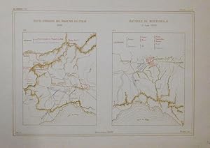
2 Pläne auf 1 Blatt, mit eingezeichneten Truppenstellungen.
Anbieter: Antiquariat Martin Barbian & Grund GbR, Saarbruecken, Deutschland
Bewertung:
Kunst / Grafik / Poster
Farblithographie von M. A. Nicoulaux bei E. Druinaud, 1883, 24x35 cm, mit beiliegenden Textblatt.
-
Zustand: Fine. The book is in fine condition.
-
Zustand: Fine. Number of books: 1 book.
-
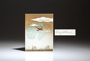
United Air Lines Flight Menu - the "Eisenhower Special"
Verlag: United Air Lines Flight Kitchen, Chicago, 1952
Anbieter: The First Edition Rare Books, LLC, Cincinnati, OH, USA
Verbandsmitglied: ABAA ILAB IOBA MWABA
Bewertung:
Erstausgabe Signiert
Paper. Zustand: Near fine. Inscribed by General Dwight D. Eisenhower, the "Eisenhower Special" flight menu from July 14, 1952, en route from the Republican National Convention in Chicago to Denver. The menu was prepared by Eugene Ertle of Chicago. (illustrator). Flight Menu. Folded menu, color illustrations, measures 6" x 4.5". Includes napkin from the flight. Housed in custom blue cloth folder, title in gilt over red morocco on cover. Signed on the menu card: "For Ellie, with best wishes, Dwight Eisenhower." After a contentious 1952 Republican National Convention in Chicago, where General Dwight D. Eisenhower prevailed over Senator Robert Taft of Ohio and Gov. Earl Warren of California to win the Republican presidential nomination, Eisenhower traveled to Fraser, Colorado for a short vacation. He traveled aboard a commercial aircraft operated by United Airlines, assigned to the Eisenhower campaign. Eisenhower and his wife, Mamie, planned to spend the week in Colorado, fly fishing, golfing, and visiting with Mamie's mother, Mrs. Elivera M. Doud. The "Eisenhower Special" was a cross-country campaign involving automobile parades, whistle-stop train tours, and air-travel.
-
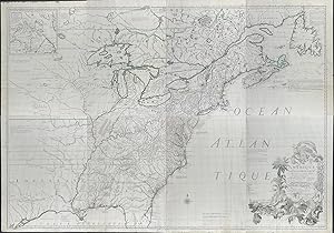
Map of eastern North America (Amà rique septentrionale avec les routes, distance en miles, villages et à tablissements françois et anglois)
Verlag: Paris, 1777
Kunst / Grafik / Poster
Zustand: Fine. This impressive map the Georges-Louis Le Rouge edition of John Mitchell's important eight-sheet map and is entitled "Amà rique septentrionale avec les routes, distance en miles, villages et à tablissements françois et anglois." The map was published in Paris by Le Rouge in 1777. --- This is the French edition of John Mitchell's map of North America. It is a landmark map of the continent. It was first completed in 1750 with the first state published in 1755 by Andrew Miller. The second state was published in 1757 with added text blocks. Jeffreys and Faden bought the copperplates after 1769 and printed it in three editions. The map was produced in French, Dutch, and Italian editions as well. This being the French translation by Georges-Louis Le Rouge that incorporated some corrections done by M. hawkins in 1776. --- The map was produced by Mitchell and commissioned by George Montagu Dunk, Lord Halifax. They were able to gather important cartographic material from the colonies including contributions from the London officers of the Hudson's Bay Company as well as the governors of Massachusetts Bay, New Jersey, Pennsylvania, Virginia, and North Carolina. They provided the following maps and information that helped inform this map: a map of the territories they claimed to the north of New France; a large map of New England specially surveyed and compiled by Richard Hazzen; an impression of Lewis Evans's map of Pennsylvania, New Jersey and New York (as well as a manuscript version); map of the province of Virginia by Joshua Fry and Peter Jefferson; a plan of Virginia and North Carolina. --- The map extends from Louisiana to the Atlantic Ocean and from Hudson Bay in Canada to Florida and the Gulf of Mexico. The map illustrated the British territories of Virginia, the Carolinas, and Georgia. It has an inset of Hudson Bay and Labrador. It features an elegant cartouche and two compass roses. The colonies are very details with forts, travel routes, lakes, rivers, and villages. --- The map became a standard in the late 1700s and was widely distributed to government officials. It was used to solve border disputes because of its great detail and wide adoption. John Jay utilized it for the Paris Treaty of 1783 that ended the American Revolution and recognized the United States of America's independence. Nicolas King also adopted it to prepare a map for Meriwether Lewis. --- John Mitchell (1711 - 1768) was a British-American mapmaker. He was born in Virginia but educated in Europe. He studied medicine and practiced in Virginia. He was elected to the American Philosophical Society in 1744 and the Royal Society in 1748 (after moving to London in 1746). He is known only for his 'Mitchell Map' but this is considered the most important map in 18th century American history. In 1749, George Montagu Dunk, Lord Halifax contracted Mitchell to produce a large, detailed map of British and French claims in America during a time of increasing tension of their American interests. --- Georges-Louis Le Rouge (c1707 - c1790) was a Paris based, German-born engraver, map and book publisher. He served as the engineer-geographer to King Louis XV and Louis XVI. He placed a higher importance on exact geography than current treatises as "to want to learn geography without good maps, it is wanting to reason with figures without ever having learned to draw." He produced thousands of maps and diagrams including city and town plans, atlases, military campaigns, and sea charts. --- The work is in very good to excellent condition overall. There is some paper repair at the edges. There may be a few minor imperfections or faint marks to be expected with age. Please review the image carefully for condition and contact us with any questions. --- Paper Size ~ 20" by 29 3/4" (This is the measurement for Each Sheet / Engraving. It is in 8 parts, unjoined, though the image is all stitched together to show full presentation.) ~ 20" by 29 3/4" (This is the measurement for Each.