
Gesamtpreis (1 Artikel Artikel):
Versandziel:

FADEN, W (25 Ergebnisse)
Direkt zu den wichtigsten Suchergebnissen
Produktart
- Alle Produktarten
- Bücher (9)
- Magazine & Zeitschriften
- Comics
- Noten
- Kunst, Grafik & Poster (1)
- Fotografien
- Karten (15)
-
Manuskripte &
Papierantiquitäten
Zustand
Einband
Weitere Eigenschaften
- Erstausgabe (1)
- Signiert
- Schutzumschlag
- Angebotsfoto (22)
- Kein Print-on-Demand (24)
Gratisversand
Land des Verkäufers
Verkäuferbewertung
-

Der Volksentscheid über Stuttgart 21: Aufbruch zu neuen demokratischen Ufern?
Verlag: Verlag Barbara Budrich, 2014
ISBN 10: 3847400932ISBN 13: 9783847400936
Buch
paperback. Zustand: Sehr gut. 189 Seiten; Zustand geprüft, Versand werktags innerhalb von 24 Stunden. Sehr gut erhalten RH 188232 Sprache: Deutsch Gewicht in Gramm: 500.
Mehr Angebote von anderen Verkäufern bei AbeBooks
Neu ab EUR 19,90
Gebraucht ab EUR 17,49
Mehr entdecken Softcover
-

Political Participation in France and Germany (Studies in European Political Science)
Verlag: ECPR Press, 2014
ISBN 10: 1907301836ISBN 13: 9781907301834
Buch
Paperback. Zustand: Brand New. 330 pages. 8.43x5.85x0.73 inches. In Stock.
-
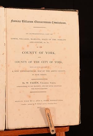
Nomina Villarum Eboracensium Comitatuum An Alphabetical List of Towns, Villages, Hamlets, Seats of the Nobility and Gentry &c &c, in the County of York, and County of the City of York, Being an Index Adapted to a New Topographical Map of the Above Country, in Four Sheets
Verlag: W. Bulmer, London, 1817
Hardback. Zustand: Good. None (illustrator). A very scarce copy of this topographical work on the county of York, produced by the former royal geographer to King George III. A very scarce work. This work was produced to accompany a 'New Topographical Map of York' which was published alongside it. This list references to the location of the villages and towns on the map, as well as giving information about which Riding of Yorkshire the location is in, the local Parish, and the wapentake of the location. The list is smartly laid out, having the borough and market town in capitals, parishes, townships, hamlets and villages in Roman print, and houses, parks, farms, halls, and ruins being in italics. William Faden was the royal geographer to King George III, it being his job to supply and publish maps to the crown and parliament. His best known work is possibly his plan of New York Island. In the original paper covered boards. Externally, generally sound. Light markings to the boards, mostly focused to the front board. A little rubbing to the paper to the joints, which has resulted in just a little loss. Minor bumping to the head and tail of the spine and to the extremities. Front hinge is starting but firm. Internally, firmly bound. Pages are bright and generally clean with scattered spotting, being heavier to the first and last few pages. Good. book.
-

Opioids II
Verlag: Springer Berlin Heidelberg, 2011
ISBN 10: 364277542XISBN 13: 9783642775420
Buch Print-on-Demand
Zustand: New. Dieser Artikel ist ein Print on Demand Artikel und wird nach Ihrer Bestellung fuer Sie gedruckt. This two-volume book provides the first comprehensive survey of opioid research, a field which has accumulated a tremendous amount of literature since the identification of opioid receptors and their endogenous ligands. In more than 60 chapters experts pres.
-
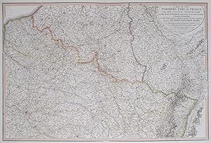
A Map of the Northern Part of France, with the United Netherlands, with the Course of the Rhine from Upper Alsace to Dusseldorf; to facilitate the Knowledge of the Operation Carried on by the Allied Armies Against the French Conventional.
Verlag: LondonW. Faden., 1815
Anbieter: Robert Frew Ltd. ABA ILAB, London, Vereinigtes Königreich
Verbandsmitglied: ABA ILAB PBFA
Bewertung:

Karte
(Sheet size: 59 x 84 cm). Double page map showing northern France and part of the United Netherlands from Flanders in the north to Champagne and Lorraine in the south. Original hand colour. Some offsetting from title.
-

A Map of the Dutchy of Holstein with the Territories of the Imperial Towns Hamburg and Lübek also the Bishoprick of Eutin laid down by Fischer's Map and Corrected by B._.
Verlag: LondonW. Faden., 1804
Anbieter: Robert Frew Ltd. ABA ILAB, London, Vereinigtes Königreich
Verbandsmitglied: ABA ILAB PBFA
Bewertung:
Karte
(Sheet size: 58 x 80 cm). Double page map of the Duchy of Holstein with various sites such as fortified towns, market towns and castles visibly marked with a key. Original hand colour. Some light offsetting, else very good.
-

Ethical Issues in Social Science Research
Verlag: The Johns Hopkins University Press, 1982
ISBN 10: 0801826551ISBN 13: 9780801826559
Buch
hardcover. Zustand: Acceptable. Acceptable. book.
-
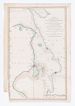
Chart of the Straits Betweem Denmark and Sweden Shewing the Passage from the Kattegat through the Sound, to Copenhagen Road; and thence through through the Grounds to the Entrance of the Baltic.
Verlag: LondonW. Faden., 1801
Anbieter: Robert Frew Ltd. ABA ILAB, London, Vereinigtes Königreich
Verbandsmitglied: ABA ILAB PBFA
Bewertung:
Karte
(Sheet size: 66 x 45 cm). Single page map with original hand colour. Foot of right hand margin cropped. Some light offsetting, else good.
-

The County of Suffolk, Reduced from the Large Map in 6 Sheets, Surveyed by Joseph Hodskinson, and Planned for a Scale of Half and Inch to One Mile. Printed for Willm. Faden, Geographer to the King.
Verlag: London: W Faden, 1797
Anbieter: David Ford Books PBFA, Cley-next-the-Sea, Vereinigtes Königreich
Verbandsmitglied: PBFA
Bewertung:
Karte Erstausgabe
Zustand: Very Good. First edition, January 1 1797. Engraved map on paper laid onto linen, with hand-colouring to hundreds boundaries, coasts and woods, folding into 18 sections, with publisher's label to back, and original slipcase of card covered in blue paper, with publisher's label to front. Opened out size: 59 x 80cm; folded: 21 x 14 cm. The map itself is in Very Good condition, the surface mostly clean and bright, with some light browning and spotting, plus a few light handling marks ; the linen on the verso is tanned and with various handling marks. The slip case is fair only, having done its job over the years: worn and abraded, though original label is good, and it is still holding together as a case.
-
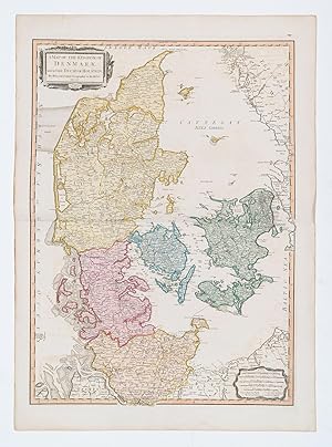
A Map of the Kingdom of Denmark, with the Duchy of Holstein.
Verlag: LondonWilliam Faden., 1790
Anbieter: Robert Frew Ltd. ABA ILAB, London, Vereinigtes Königreich
Verbandsmitglied: ABA ILAB PBFA
Bewertung:
Karte
(81.5 x 59 cm). Double page map of Denmark and the surrounding islands including Zealand, Tunen and Langeland. Original colour. Title in decorative cartouche. Some offsetting, else good.
-
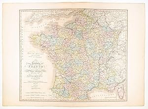
The Kingdom of France Describing the New Limits according to the Treaty of Paris, November 20th 1815.
Verlag: LondonW. Faden., 1816
Anbieter: Robert Frew Ltd. ABA ILAB, London, Vereinigtes Königreich
Verbandsmitglied: ABA ILAB PBFA
Bewertung:
Karte
(Sheet size: 59 x 82 cm). Double page map of France divided up into its various départements with the principal town of each underlined. Original hand colouring. Tear without loss at join of two sheets. Some light offsetting.
-

The Coast of Guyana from the Oroonoko to the River of Amazons and Inland Parts as far as they have been Explored by the French & Dutch Engineers with the Islands of Barbados Tobago &ca.
Verlag: LondonW. Faden., 1783
Anbieter: Robert Frew Ltd. ABA ILAB, London, Vereinigtes Königreich
Verbandsmitglied: ABA ILAB PBFA
Bewertung:
Karte
(Sheet size: 59 x 80 cm). Double page map of the coast of Guyana with inset plans of the entrance of the River Beatrice, Surinam River, Port of Cayenne and part of the rivers Essequebo and Demerari. Also includes 'Remarks and Observations on the Coast of Guyana' and 'The Entrances of the Rivers Essequebo and Demerari' by Captain Thompson. Information on astronomical observations and geographical features is provided in tables and annotations. Original hand colour. Tear without loss at left hand margin. Edges worn with small tears. Some light offsetting, otherwise clean and bright.
-
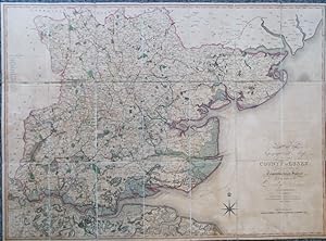
A Topographical Map of the County of Essex. Constructed from the Trigonometrical Survey Made by Order of the Board of Ordnance
Verlag: London: W. Faden, July 6th, 1804
Anbieter: Bow Windows Bookshop (ABA, ILAB), Lewes, Vereinigtes Königreich
Verbandsmitglied: ABA ILAB PBFA
Bewertung:
Karte
Map dimensions 63 x 87 cm, overall 64.5 x 88 cm. An attractive folding map of the county with original colour in block and outline. Scale: ˝ inch to one mile. Dissected into 21 sections and mounted on linen, both folded end sections with marbled paper tabs, one side with a publisher's label, folds into original marbled paper slipcase with printed label to upper cover. Some wear to the case with the upper edge of one joint cracked, the map slightly browned overall, otherwise a very good copy. Essex was the second Ordnance Survey map to be published, preceded by Kent in 1801. This is the true first edition of their map of the county, the full four sheet version being published the following year. Rare, the only institutional copies found are in the British Library, Cambridge and Oxford. The only auction record is the Wardington copy, sold at Sotheby's in 2006.
-
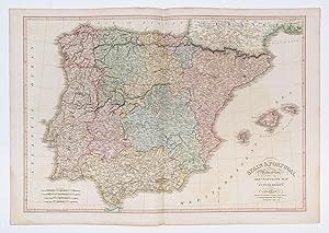
Spain and Portugal. Reduced from Jas.r Nantiat's Map in Four Sheets.
Verlag: LondonW. Faden., 1812
Anbieter: Robert Frew Ltd. ABA ILAB, London, Vereinigtes Königreich
Verbandsmitglied: ABA ILAB PBFA
Bewertung:
Karte
(Sheet size: 59 x 84 cm). Double page map of Spain and Portugal including the Balearic Islands. Original hand colour. Light water staining at bottom left and right hand corners. A little offsetting.
-
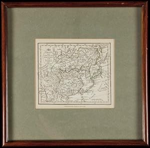
Hardcover. Zustand: Fine. Description: Copper-engraved map, slight hand-coloring in outline. sight 10 x 11.5 cm. (4" x 4 1/2"), matted and framed 23.5 x 23.5 cm (9 1/4" x (1/4") under plexiglass. Charming little map of easter Asia. Lat 18th century Eastern Asiatic map of China, Corea and Japan produced during the reign of Emperor Jiaqing. The title is engraved on shield in the upper left hand corner. Condition: Fine; not examined out of frame.
-
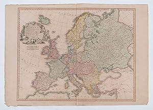
Europe, Exhibiting its Principal States. &c.
Verlag: LondonWilliam Faden., 1817
Anbieter: Robert Frew Ltd. ABA ILAB, London, Vereinigtes Königreich
Verbandsmitglied: ABA ILAB PBFA
Bewertung:
Karte
(Sheet size: 57 x 80 cm). Double page map of Europe. Title set in attractive pictorial cartouche. Original hand colour. Some light offsetting. Some light spotting to left margin. Else good.
-
Hampshire Or The County of Southampton Including The Isle of Wight Reduced From the Large Map In Six Sheets [Folding Linen Backed Card Map - 68 x 58cm - 26 x 23 Inches]
Verlag: London: W Faden, 1796
Anbieter: Louis88Books (Members of the PBFA), Andover, Vereinigtes Königreich
Verbandsmitglied: PBFA
Bewertung:
Buch
Hardcover. Zustand: Good. London: W Faden, 1796 Early Edition, Reduced from the Large Map (approx. 27 x 23 inches). Linen backed folding map mounted on card, some of the linen a little loose but holding well. Includes Canal from Basingstoke to the River Wey, Canal from Andover to Redbridge, Contents of Aliceholt and Woolmer Forests, Contents of New Forest, Colouring Of The Forest Lands. Colour, with coloured borders. Size Unfolded: 26 ľ inches tall and 23 wide (68 x 58cm). Size Folded: 6 ˝ inches tall and 5 ˝ inches wide (16.5 x 14cm). Condition Report Externally See above and photos. Internally See above and photos. Publisher: See above. Publication Date: 1796 Binding: Hardback.
-

A Map of Ireland divided into Provinces and Counties, showing the Great and Cross Roads with the distances of the principal Towns from Dublin.
Verlag: LondonWilliam Faden, 1798
Anbieter: Robert Frew Ltd. ABA ILAB, London, Vereinigtes Königreich
Verbandsmitglied: ABA ILAB PBFA
Bewertung:
Karte
(Sheet size: 82 x 59 cm). Double page map of Ireland. Original hand colour. Good condition.
-
The Country Twenty-Five Miles Round London, Planned from a scale of One Mile to an Inch. Third Edition.
Verlag: London, Wm. Faden, 1815 3rd., 1815
Anbieter: PROCTOR / THE ANTIQUE MAP & BOOKSHOP, DORCHESTER, Vereinigtes Königreich
Verbandsmitglied: PBFA
Bewertung:
Large engraved coloured map 24 x 30 inches. 32 Cut sections mounted on canvas backing. In marbled slipcase with title label to front. Very good condition with good slipcase. (SC heavily rubbed, edges chipped, split at edge, some writing to front.) Some minor tanning to Map, else clean with bright colouring. Some browning to canvas on rear side. Else a very good large map. Full hand colouring.
-
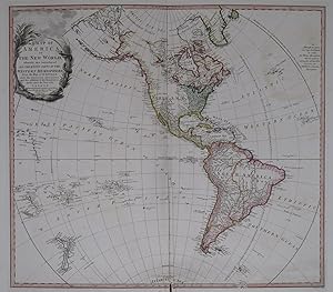
A Map of America or the New World, wherein are introduced all the known parts of the Western Hemisphere From the Map of d'Anville with the necessary alterations and the addition of the Discoveries made since the Year 1761.
Verlag: LondonW. Faden, 1797
Anbieter: Robert Frew Ltd. ABA ILAB, London, Vereinigtes Königreich
Verbandsmitglied: ABA ILAB PBFA
Bewertung:
Karte
(Sheet size: 59 x 80 cm). Double page map of the Americas with the Polynesian Islands and New Zealand. Decorative title cartouche. Original hand colour. Tear without loss at central join else very good.
-
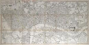
A Plan of London and Westminster With The Borough Of Southwark.
Verlag: LondonW. Faden. Charing Cross. Jany., 1821
Anbieter: Robert Frew Ltd. ABA ILAB, London, Vereinigtes Königreich
Verbandsmitglied: ABA ILAB PBFA
Bewertung:
Karte
Overall dimensions 47.x 92 cm. Original colour, mostly in outline but also in block to the squares. A detailed and well executed folding plan of London showing the extents from Islington to Newington and Stepney to Hyde Park. The plan dissected into 24 sections and backed on to linen. Folds into original orange-brown marbled paper card slipcase, small publisher's labels pasted on upper board . Identical publisher's label to verso of one of the end sections, matchhing marbled paper tabs on the verso of both end sections. The slipcase worn at extremities, otherwise sound. Some ink stains to linen backing, but not affecting the recto of the plan. A few spots to centre of image, though the plan generally very clean and in very good condition. Cf Howgego, No. 269 for 1817 edition, no 1821 edition listed.
-
ENVIRONS OF LONDON [Folding Linen Backed Map - 53.3 x 51cm - 21 x 20 Inches approximately each sheet]
Verlag: Tower [London]: Col Mudge, 1816
Anbieter: Louis88Books (Members of the PBFA), Andover, Vereinigtes Königreich
Verbandsmitglied: PBFA
Bewertung:
Karte
Soft cover. Zustand: Good. Tower [London]: Col Mudge, 1816 - 1819 Early Edition, 4 folding maps [Ordnance Survey?] in the original slipcase (each approx. 20 x 21 inches). Linen backed folding maps mounted on card, some of the linen a little loose but holding well. Colour, with coloured borders. Each sheet signed in both corners by a previous owner. The South West sheet with a tear along the fold for one section. William Mudge (1762 1820) was an English artillery officer and surveyor, born in Plymouth, an important figure in the work of the Ordnance Survey. Size Unfolded: 20 inches tall and 21 wide (51 x 53.3cm). Size Folded: 7 inches tall and 4 ˝ inches wide (18 x 11.5cm). Condition Report Externally See above and photos. Internally See above and photos. Publisher: See above. Publication Date: 1816-1819 Binding: Hardback.
-
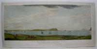
Cape Carthage Tunis Bay and Goletta
Verlag: London, 1786
Anbieter: Alexandre Antique Prints, Maps & Books, Toronto, ON, Kanada
Bewertung:

Kunst / Grafik / Poster
Zustand: Very Good. A scenic view of Cape Carthage in the Gulf of Tunis across the water from Sicily., Image Size : 300x755 (mm), 11.75x29.75 (Inches), Platemark Size : 355x780 (mm), 14x30.75 (Inches), Paper Size : 390x810 (mm), 15.375x31.875 (Inches), Hand Colored, Aquatint.
-
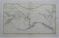
Chart of the N.W. Coast of America and the N.E. Coast of Asia Explored in the Years 1778 and 1779
Verlag: W. Faden, London, 1794
Anbieter: Alexandre Antique Prints, Maps & Books, Toronto, ON, Kanada
Bewertung:
Karte
Zustand: Very Good. An important map of the North West. Published by William Faden as part of his post revolutionary atlas of North America. The map covers from the west coast to Hudsons Bay to Washington state in the south. There is a detailed path of the Captain Cooks voyage is also deliniated., Size : 430x710 (mm), 16.875x27.875 (Inches), Original Outline Coloring, 0.

![Bild des Verkäufers für Hampshire Or The County of Southampton Including The Isle of Wight Reduced From the Large Map In Six Sheets [Folding Linen Backed Card Map - 68 x 58cm - 26 x 23 Inches] zum Verkauf von Louis88Books (Members of the PBFA)](https://pictures.abebooks.com/inventory/md/md31029980225.jpg)
![Bild des Verkäufers für ENVIRONS OF LONDON [Folding Linen Backed Map - 53.3 x 51cm - 21 x 20 Inches approximately each sheet] zum Verkauf von Louis88Books (Members of the PBFA)](https://pictures.abebooks.com/inventory/md/md31064146517.jpg)