
Gesamtpreis (1 Artikel Artikel):
Versandziel:

FREDERICK DE WIT (259 Ergebnisse)
Direkt zu den wichtigsten Suchergebnissen
Produktart
- Alle Produktarten
- Bücher (140)
- Magazine & Zeitschriften
- Comics
- Noten
- Kunst, Grafik & Poster (43)
- Fotografien
- Karten (76)
-
Manuskripte &
Papierantiquitäten
Zustand
Einband
Weitere Eigenschaften
- Erstausgabe (1)
- Signiert (1)
- Schutzumschlag (7)
- Angebotsfoto (209)
- Kein Print-on-Demand
Land des Verkäufers
Verkäuferbewertung
-
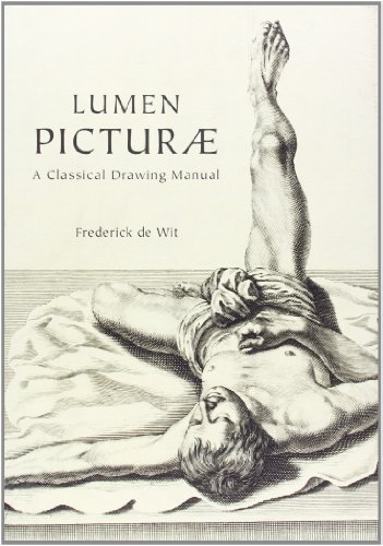
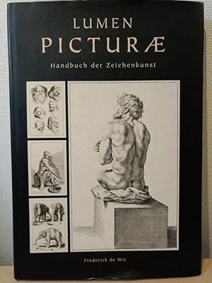
Lumen Picturae: A Classical Drawing Manual
Verlag: Harper Design, 2011
ISBN 10: 0062048880ISBN 13: 9780062048882
Buch
Hardcover. Zustand: Very Good. Connecting readers with great books since 1972! Used books may not include companion materials, and may have some shelf wear or limited writing. We ship orders daily and Customer Service is our top priority!.
Mehr Angebote von anderen Verkäufern bei AbeBooks
Neu ab EUR 28,08
Gebraucht ab EUR 13,87
Mehr entdecken Hardcover
-
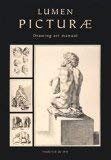
Lumen Picturae: Drawing Art Manual
Verlag: FKG. 1 Cloth(s), 2010
ISBN 10: 849273177XISBN 13: 9788492731770
Buch
Hardcover. Zustand: Very Good. Zustand des Schutzumschlags: Very Good. Free of markings.
-
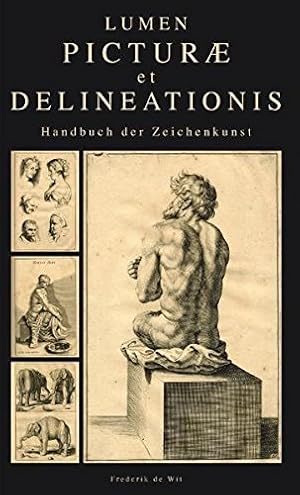
Lumen picturae - Handbuch der Zeichenkunst.
Verlag: Köln, Komet, 2010
ISBN 10: 3898369730ISBN 13: 9783898369732
Anbieter: ACADEMIA Antiquariat an der Universität, Freiburg, Deutschland
Verbandsmitglied: BOEV
Bewertung:

Buch
Zustand: Sehr gut. 171 Seiten. 43 cm Gebunden mit Schutzumschlag. Sehr gut. Sprache: Deutsch Gewicht in Gramm: 2461.
Mehr Angebote von anderen Verkäufern bei AbeBooks
Neu ab EUR 295,91
Gebraucht ab EUR 24,00
Mehr entdecken Hardcover
-

Barcelona, Loft Publications, 2010. Hard Cover (with dustjacket). Text in Dutch, German, Spanish, French, Italian and English. 171 pp (nearly all with drawings). Wear to corner top dustjacket. Good copy. 30x43 cm.
-
Lumen Picturae: Handbuch der Zeichenkunst. Hg.: Paco Asensio:.
Verlag: Köln: Komet Vlg. 2010., 2010
Anbieter: Antiquariat Bergische Bücherstube Mewes, Overath, Deutschland
Verbandsmitglied: GIAQ ILAB VDA
Bewertung:
171 S., Tafelteil. 2° Kart.mS: *neuwertig*.
-
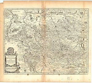
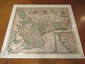
Ducatus Brunsvicensis fereq Lunaeburgensis, cum Adjacentibus Episcopatibus, Comit. Domin. etc.
Verlag: Amsterdam ., 1682
Anbieter: Robert Frew Ltd. ABA ILAB, London, Vereinigtes Königreich
Verbandsmitglied: ABA ILAB PBFA
Bewertung:
Karte
Original uncoloured double-page copper engraved map with a decorative cartouche to lower left corner. Map dimensions 28 x 36 cm, overall sheet dimensions 34.5 x 39 cm. Light toning and a few nicks to margins, lightly toned down centre-fold, generally very good condition.
-
Fol., gebunden. Zustand: Sehr gut. 171 Seiten Geringe Lagerspuren am Schutzumschlag, Buch selbst einwandfrei. Sprache: Deutsch Gewicht in Gramm: 2426.
-

Tabula Comitatus Artesiae" - Artois Arras Douai Bethune Saint-Omer Aire Muntrevil carte gravure
Verlag: Amsterdam ca. 1680., 1680
Anbieter: Antiquariat Steffen Völkel GmbH, Seubersdorf, Deutschland
Bewertung:
Karte
Großformatige altkolorierte Kupferstich-Karte von ca. 1680. Rückseitig ohne Text. -- Blatt-Maße: ca. 53 x 61 cm. -- gut erhalten. || Large old colored engraved map from c. 1680. -- Without text on verso. -- in good condition. || Dies ist ein Original! - Kein Nachdruck! - Keine Kopie! -- This is an original! - No copy! - No reprint! la Gewicht in Gramm: 1550.
-
[Tielt], Lannoo, [Den Haag], Koninklijke Bibliotheek & [Bruxelles], Racine, 2012. 319 pp. 112 col. plts with 151 maps / views of cities and fortifications. Orig. hardcover (pictorial boards). Large folio. - Two corners of cover sl. worn.Reprint of Frederik de Wit's Theatrum ichnographicum omnium urbium et praecipuorum oppidorum Belgicarum XVII Provinciarum [.]. (Amst., ca. 1698). - - Text in Dutch, French & English by Marieke van Delft & Peter van der Krogt.
-
Nieut Kaert boeck vande XVII Nederlandsche Provincien.
Anbieter: Antiquariaat A. Kok & Zn. B.V., Amsterdam, Niederlande
Bewertung:
Amst., F. de Wit, 1670-1672 [Reprint Alphen a.d. Rijn, 1999]. 22,16 pp. 49 b./w. maps. Imitation leather. Folio.Facsimile of De Wit's "Germania Inferior, Sivč XVII Provinciarum". - With an introduction (22 pages, Dutch & French text) by H.A.M. van der Heijden.
-
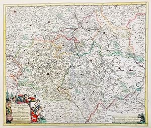
Circuli Saxoniae Superior Pars Meridionalis in qua sunt Ducatus Saxoniae, Comitatus Mansfeldiae et Voitlandiae, Landgraviat Thuringiae, Marchionatus Misniae, Principatus Anhaltinus et Episcopatus Hallensis." - Sachsen Anhalt Magdeburg Thüringen Erfurt Leipzig Dresden Plauen Eisenach Halberstadt Dessau
Verlag: Amsterdam ca. 1680., 1680
Anbieter: Antiquariat Steffen Völkel GmbH, Seubersdorf, Deutschland
Bewertung:
Karte
Großformatige altkolorierte Kupferstich-Karte von ca. 1680 Rückseitig ohne Text. -- Blatt-Maße: ca. 53 x 61 cm. -- im unteren Mittelbug leicht eingerissen, sonst gut erhalten. || Large old colored engraved map from c. 1680. -- Without text on verso. -- with a split on the lower part of the centerfold, otherwise in good condition. || Dies ist ein Original! - Kein Nachdruck! - Keine Kopie! -- This is an original! - No copy! - No reprint! la Gewicht in Gramm: 1550.
-
Amsrerdam 1980, maps, reprint of ca 1698 a242.
-
[Tielt], Lannoo, [Den Haag], Koninklijke Bibliotheek & [Bruxelles], Racine, 2012. 319 pp. 112 col. plts with 151 maps / views of cities and fortifications. Orig. hardcover (pictorial boards). Large folio. - Still in the original packaging boxes (outer box with some damage).Reprint of Frederik de Wit's Theatrum ichnographicum omnium urbium et praecipuorum oppidorum Belgicarum XVII Provinciarum [.]. (Amst., ca. 1698). - - Text in Dutch, French & English by Marieke van Delft & Peter van der Krogt.
-
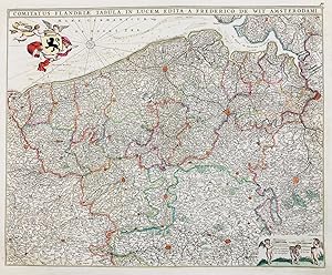
Comitatus Flandriae Tabula" - Vlaanderen Flandre Flanders Flandern Brugge Gand Lille Oudenaarde
Verlag: Amsterdam ca. 1680., 1680
Anbieter: Antiquariat Steffen Völkel GmbH, Seubersdorf, Deutschland
Bewertung:
Karte
Großformatige altkolorierte Kupferstich-Karte von ca. 1680. Rückseitig ohne Text. -- Blatt-Maße: ca. 53 x 61 cm. -- gut erhalten. || Large old colored engraved map from c. 1680. -- Without text on verso. -- in good condition. || Dies ist ein Original! - Kein Nachdruck! - Keine Kopie! -- This is an original! - No copy! - No reprint! la Gewicht in Gramm: 1550.
-
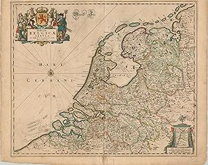
Foederatae Belgicae Tabula Gorgeous map of the United Provinces, or Dutch Republic, by de Wit.
Verlag: c. 1680, 1680
Anbieter: Curtis Wright Maps, Berwyn, IL, USA
Bewertung:

Zustand: Very Good. This detailed 17th century copperplate engraved map shows the Dutch Republic, or the United Provinces of the Netherlands; an independent entity since the Dutch Revolt of 1588. The map was published in Amsterdam by Frederick de Wit nearly 100 years later, and shows the fledgling republic sandwiched between the Spanish Netherlands to the south, and the Holy Roman Empire to the east. Geographic details like rugged terrain, forests, cities, lowlands, maritime hazards and rivers are depicted pictorially, and attractive hand color has been applied to differentiate between the various provinces. An inset map in the lower right shows a continuation of the River Meuse to Maastricht, which lies on the border with modern day Belgium. A decorative cartouche in the upper left corner completes the image and features the coat of arms of the Dutch Republic and several figures representing the military, maritime, and commercial strength of the nation. Sheet Width (in) 24 Sheet Height (in) 19.9 Condition Description Scattered foxing in several places within the image, and moderate wear visible along the centerfold and in the margins. Several tears in the margins, concentrated most heavily along the lower center edge, have been repaired on the verso with archival tape. Features lovely old hand color.
-
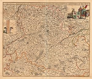
Comitatus Hannoniae et Episcopatus Cambresis Descriptio, Auctore F. de Wit.
Verlag: Amsterdam, 1690
Anbieter: Antiquariat Reinhold Berg eK Inh. R.Berg, Regensburg, Deutschland
Bewertung:
Karte
Other. Copper engraving, handcolored when published. Decorative map of 'Hannonia' published in a Dutch composite atlas around 1690. In very good condition. 464 by 547mm (18Ľ by 21˝ inches). 464 by 547mm (18Ľ by 21˝ inches).
-
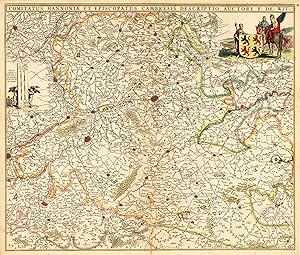
Comitatus Hannoniae et Episcopatus Cambresis Descriptio, Auctore F. de Wit.
Verlag: Amsterdam, 1690
Anbieter: Antiquariat Reinhold Berg eK Inh. R.Berg, Regensburg, Deutschland
Bewertung:
Karte
Other. Copper engraving, handcolored when published. Decorative map of 'Hannonia' published in a Dutch composite atlas around 1690. In very good condition. 464 by 547mm (18Ľ by 21˝ inches). 464 by 547mm (18Ľ by 21˝ inches).
-

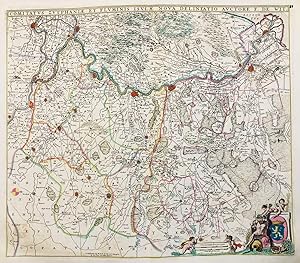
Comitatus Namurci Tabula in Lucem edita á Frederico de Wit.
Verlag: de Wit 1680-86, Amsterdam, 1680
Anbieter: Antiquariat Reinhold Berg eK Inh. R.Berg, Regensburg, Deutschland
Bewertung:
Karte
Other. Copper engraving, hand colored in outline and wash. In very good to excellent condition. Minor creases at the centre fold. 463 by 543mm (18Ľ by 21˝ inches). 463 by 543mm (18Ľ by 21˝ inches).
-
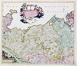
Ducatus Meklenburgicus in quo sunt Ducatus Vandaliae et Meklenburgi Comitatus et Episcopatus Swerinensis Rostochiense et Stargardiense Domin." - Mecklenburg-Vorpommern Rostock Ostsee Wismar Schwerin Güstrow Stralsund
Verlag: Amsterdam ca. 1680., 1680
Anbieter: Antiquariat Steffen Völkel GmbH, Seubersdorf, Deutschland
Bewertung:
Karte
Großformatige altkolorierte Kupferstich-Karte von ca. 1680 Rückseitig ohne Text. -- Blatt-Maße: ca. 53 x 61 cm. -- im unteren Mittelbug etwas eingerissen, sonst gut erhalten. || Large old colored engraved map from c. 1680. -- Without text on verso. -- with a split on the lower part of the centerfold, otherwise in good condition. || Dies ist ein Original! - Kein Nachdruck! - Keine Kopie! -- This is an original! - No copy! - No reprint! la Gewicht in Gramm: 1550.
-
Comitatus Zutphaniae et Fluminis Isulae Nova Delineatio" - Zutphen Deventer Arnhem Doesburg Nijmegen Lochem Zwolle Nederland Niederlande Netherlands Holland
Verlag: Amsterdam ca. 1680., 1680
Anbieter: Antiquariat Steffen Völkel GmbH, Seubersdorf, Deutschland
Bewertung:
Karte
Großformatige altkolorierte Kupferstich-Karte von ca. 1680. Rückseitig ohne Text. -- Blatt-Maße: ca. 53 x 61 cm. -- gut erhalten. || Large old colored engraved map from c. 1680. -- Without text on verso. -- in good condition. || Dies ist ein Original! - Kein Nachdruck! - Keine Kopie! -- This is an original! - No copy! - No reprint! la Gewicht in Gramm: 1550.
-

Ducatus Geldriae, et Comitatus Zutphaniae, Tabula" - Nederland Niederlande Netherlands Holland Nijmegen Amersfoert 's-Hertogenbosch Arnhem Geldern Wesel
Verlag: Amsterdam ca. 1680., 1680
Anbieter: Antiquariat Steffen Völkel GmbH, Seubersdorf, Deutschland
Bewertung:
Karte
Großformatige altkolorierte Kupferstich-Karte von ca. 1680. Rückseitig ohne Text. -- Blatt-Maße: ca. 53 x 61 cm. -- gut erhalten. || Large old colored engraved map from c. 1680. -- Without text on verso. -- in good condition. || Dies ist ein Original! - Kein Nachdruck! - Keine Kopie! -- This is an original! - No copy! - No reprint! la Gewicht in Gramm: 1550.
-
Accurata Scaniae Blekingiae, Et Hallandiae Descriptio Per F. De Wit Amstelodami.
Verlag: De Wit [De Witt], Frederick, Amsterdam, 1680
Anbieter: Arroyo Seco Books, Pasadena, Member IOBA, Pasadena, CA, USA
Verbandsmitglied: IOBA
Bewertung:
Karte Erstausgabe
No Binding. Zustand: Very Good. Original Map With Extensive Coloring (illustrator). 1st Edition. Single Sheet Extracted From De Wit's Atlas, 20 1/4" X 24 1/4". Decorative Putti. Extensive Coloring. Map Shows Southern Sweden And Eastern Denmark Including Copenhagen, With Inset Map Of Hallandia Septrionalis Including Gottenborg. Some Light Foxing, One 1/4" Area Of Dark Foxing In Sea At Lower Left. Small Label, Not Attached To Map, Of Guarantee By Anne Bailly Kahn Of L'astrolabe.
-
Theatrum ichnographicum omnium urbium Belgicarum XVII provinciarum peraccurate delineatarum. / Perfecte aftekeningen der steden van de XVII Nederlandsche provincien in plattegronden. / Le theatre des plans de toutes les vills [.].
Anbieter: Antiquariaat A. Kok & Zn. B.V., Amsterdam, Niederlande
Bewertung:
Amsterdam, ca. 1698. [Reprint Amsterdam, Van Hoeve, 1980]. Unpaginated. 1 b./w. plate with the coats of arms of provinces of the Netherlands & [128] double-page b./w. facs. plans / views. Orig. hardcover (brown cloth, gilt lettered / dec. spine). Large folio.Reprint (with the addition of five maps) of the first edition: Amsterdam, Frederick de Wit, ca. 1698. - With loosely inserted introduction / index booklet :"Stedenatlas / Book of towns / Leivre des plans des villes" (9 pp.) with text in Dutch, French & English.
-
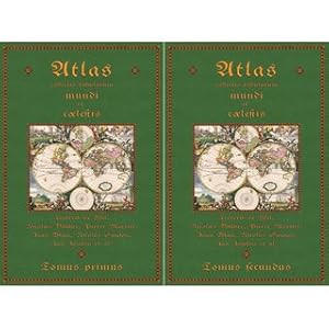
Atlas collectio tabularum mundi et coelestis in 2 Bänden Kupferplatten von Frederick de Wit, Nicolaes Visscher, Pierre Martier , Joan Blaeu
Verlag: Fines Mundi GmbH Saarbrücken, 2020
Anbieter: Versandantiquariat Nussbaum, Bernkastel-Kues, RP, Deutschland
Bewertung:
Buch
Zustand: Wie neu. Tomus I: IV Seiten Inhalt, 154 doppelblattgroße colorierte Karten Tomus II: IV Seiten Inhalt, 138 doppelblattgroße colorierte Karten tadellos neuwertig / In dieser Ausgabe fehlen folgende Karten: Band 1: die Karten 1, 2, 4, 16, 48, 49, 63 und 112 Band 2: die Karte 46 Sprache: Niederländisch Gewicht in Gramm: 7850 44,3 x 30,5 cm, gebundene Ausgabe Faksimile-Reprint der Ausgabe 1650 Amsterdam.
-
Theatrum ichnographicum omnium urbium et praecipuorum oppidorum belgicarum XVIII provinciarum peraccurate delineatarum. Perfecte aftekeningen der steden van de XVII Nederlandsche Provincien in plattegronden. Facs. van de oorspronkelijke eerste druk, verschenen te Amsterdam in ca. 1698. Facs. of the 1st ed., published at Amsterdam c. 1698.
Verlag: Amsterdam, Van Hoeve, 1980., 1980
Anbieter: Charbo's Antiquariaat, Amsterdam, Niederlande
Bewertung:
Folio. With 128 mostly double-page b/w maps. Index. Hardcover. Or. brown buckram. VG/--. (Gift dedication on front endpaper). * Incl. booklet: Frederick de Wit, Stedenatlas, Book of towns, Livre des plans des villes (Inleiding en lijst van platen. Nederlandse, Engelse & Franse tekst. Incl. loose appendix with Dutch, English & French introduction and list of plates). - Heavy item, requires extra shipping costs for destinations outside EU.
-
Accuratissima Germaniae tabula / denuo in lucem edita a Frederico de Wit. Amsterdam (ca.1680). Grenzkolorierte Kupferstichkarte 58 x 49 cm. Blattgröße 61 x 52 cm. Rechts oben kolorierte Titelkartusche mit Kaiser, Putto und Adler. Links unten graphischer Maßstab (Milliaria Germanica Communia). Die Karte ist etwas gebräunt, die Ränder mit geringen Beschädigungen. Die Ränder und Mittelpflaz wurden fachmännisch hinterlegt. Oben recht kleiner v-förmiger Einriß (ca. 3 x 3 cm).
-
Theatrum Ichnographicum omnium urbium et praecipuorum oppidorum Belgicarum XVII Provinciarum peraccurate delineatarum / Perfecte aftekeningen der steden van de XVII Nederlandsche provincidn in platte gronden / Le theatre des plans de toutes les villes qui sont situéez dans les XVII provinces du Pays bas parfaictement deseignéez.
Verlag: Amsterdam, Van Hoeve, 1980, 1980
Amsterdam, Van Hoeve, 1980. (herdruk van de uitgaaf, Amsterdam, Frederick de Wit, kort na 1697). Groot folio. 52 cm. Vollinnen. In zeer goede staat.
-

Transialania Provincia, Vulgo Over-Yssel" - Overijssel Zwolle Coevorden Deventer Meppel
Verlag: Amsterdam ca. 1680., 1680
Anbieter: Antiquariat Steffen Völkel GmbH, Seubersdorf, Deutschland
Bewertung:
Karte
Großformatige altkolorierte Kupferstich-Karte von ca. 1680. Rückseitig ohne Text. -- Blatt-Maße: ca. 53 x 61 cm. -- gut erhalten. || Large old colored engraved map from c. 1680. -- Without text on verso. -- in good condition. || Dies ist ein Original! - Kein Nachdruck! - Keine Kopie! -- This is an original! - No copy! - No reprint! la Gewicht in Gramm: 1550.
-
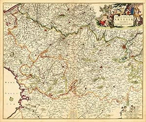
Tabula Comitatus Artesiae emendata A. Frederico de Wit.
Verlag: de Wit 1680-86, Amsterdam, 1680
Anbieter: Antiquariat Reinhold Berg eK Inh. R.Berg, Regensburg, Deutschland
Bewertung:
Karte
Other. Copper engraving, hand colored in outline and wash. In very good to excellent condition. Minor creases at the centre fold. 461 by 551mm (18Ľ by 21ľ inches). 461 by 551mm (18Ľ by 21ľ inches).
-

Jutić Tabula in quć sunt Di ceses Alburgensis, Wiburgensis, Ripensis et Arhusiensis.
Erscheinungsdatum: 1688
Anbieter: Altea Antique Maps, London, Vereinigtes Königreich
Verbandsmitglied: ABA ILAB PBFA
Bewertung:
Karte
Amsterdam, c.1688. Original colour. 585 x 480mm. Split in centrefold repaired. Some slight colour offset. Fine map of Northern Denmark, with decorative title and scale cartouches. KOEMAN: Wit 16.
