
Gesamtpreis (1 Artikel Artikel):
Versandziel:

GIOVANNI FRANCESCO CAMOCIO (54 Ergebnisse)
Direkt zu den wichtigsten Suchergebnissen
Produktart
- Alle Produktarten
- Bücher (38)
- Magazine & Zeitschriften
- Comics
- Noten
- Kunst, Grafik & Poster (5)
- Fotografien
- Karten (11)
-
Manuskripte &
Papierantiquitäten
Zustand
- Alle
- Neu
- Antiquarisch/Gebraucht
Einband
- alle Einbände
- Hardcover
- Softcover
Weitere Eigenschaften
- Erstausgabe (3)
- Signiert
- Schutzumschlag
- Angebotsfoto (53)
- Kein Print-on-Demand
Land des Verkäufers
Verkäuferbewertung
-
Castel Novo.
Erscheinungsdatum: 1575
Anbieter: Altea Antique Maps, London, Vereinigtes Königreich
Verbandsmitglied: ABA ILAB PBFA
Bewertung:

Karte
No Binding. Zustand: Good. Venice: Ferrando and/or Donato Bertelli, c.1575. 170 x 220mm. . Herceg Novi, just south of Dubrovnik, made famous by the gallant yet unsuccessful defence of the fortress by the Spanish under Francisco de Sarmiento in 1539. This map was published in Camocio's 'Isole famose, porti fortezze e terre marittime sottoposte alla Ser.ma Sig.ria di Venezia', a description of the places claimed as subject to the Republic of Venice. A later state, with plate number.
-
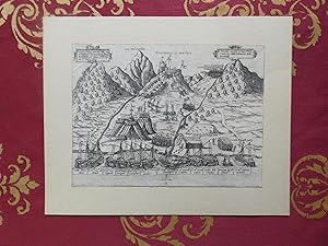
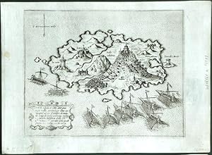
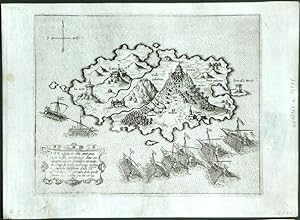
senza rilegatura. Zustand: buono. Giovanni Francesco Camocio Fortezza di Soppoto 1574, Giovanni Francesco Camocio Fortezza di Soppoto, incisione xilografica dimensioni 170x230mm applicata ad un cartoncino, rifilata al margine dell'inciso. Rara veduta animata della fortezza di Sopot nell'odierna Albania. Camocio tra il 1566 e il 1574 pubblicň circa una quarantina di vedute sia di grande che di piccolo formato che poi vennerň riunite e date alle stampe nel opera "Isole famose, porti, fortezze e terre marittime sottoposte alla serenissima Signoria di Venezia , ed ad altri Principi Christiani, et al Signor Turco, novamente poste in luce " , piccola mancaza al cartiglio posto in alto a sinistra, complessivamente buone condizioni generali.
-
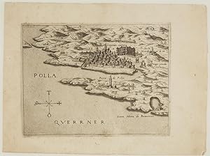
Polla Querrner.
Erscheinungsdatum: 1575
Anbieter: Altea Antique Maps, London, Vereinigtes Königreich
Verbandsmitglied: ABA ILAB PBFA
Bewertung:
Karte
No Binding. Zustand: Good. Venice: Ferrando and/or Donato Bertelli, c.1575. 135 x 180mm. Pula in southern Istria, from Camocio's 'Isole famose, porti fortezze e terre marittime sottoposte alla Ser.ma Sig.ria di Venezia', a description of the places claimed as subject to the Republic of Venice. The ancient Pula Arena is shown in profile.
-
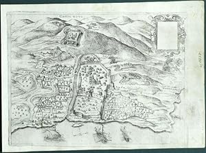
Castel Novo
Verlag: Venice, 1571
"Castel Novo". Orig. copperplate engraving from G. F. Camocio's Isole Famose . Published in Venice by Camocio, 1571. With engraved title, ornamental cartouche (blank) and 3 ships. 17:23 cm (6 3/4 x 9 inch.). First state of the plate, without the number in the lower right corner. - A rare birds-eye-view of Herceg Novi, a coastal town in Montenegro located at the entrance to the Bay of Kotor and at the foot of Mount Orjen. - Giovanni Francesco Camocio (1501-1575) was active as map publisher in Venice between 1558 and 1575. He was one of the most important mapmakers of the La Freri-school.
-
Antivari cita in confine della Dalmatia et Albania
Verlag: Venice, 1571
"Antivari cita in confine della Dalmatia et Albania . M.D.LXXI". Orig. copperplate engraving from G. F. Camocio's Isole Famose . Published in Venice by Camocio, 1571. With title-cartouche and 3 ships. 17:23 cm (6 3/4 x 9 inch.). First state of the plate, without the number in the lower right corner. - A rare birds-eye-view of Bar, a coastal town and seaport in southern Montenegro. - Giovanni Francesco Camocio (1501-1575) was active as map publisher in Venice between 1558 and 1575. He was one of the most important mapmakers of the La Freri-school.
-
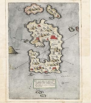
Milo insula posta nel mare dello Arcipelago longi dalla Morea
Verlag: [Venice: first years of the s], 1570
Anbieter: Antiquariat Dasa Pahor GbR, München, Deutschland
Bewertung:

Karte
Originally coloured copper engraving, 20 x 14,5 cm, mounting paper: 21,5 x 19 cm (minor staining, a tiny repaired tear in the white margin, but overall in a good condition). MILOS / GREECE: Camocio s separately issued map of the Greek island Milos with handsome old colouring - This early engraved map of the Greek island Milos, with attractive old colour, was issued in the series of maps of islands by a Venice map maker Giovanni Francesco Camocio, who started this large pioneering opus circa 1558. Maps were first published separately and later in Isole famose porti, fortezze, e terre maritime, , with various variations of maps. More common versions from this series, with a number in the lower right corner, were printed after 1575, when Camocio s plates were acquired by Donato Bertelli. References: Stefano Bifolco, Cittŕ e Fortezze Principali del Mondo, Cartografia e Topografia Italiana del XVI secolo. Catalogo ragionato delle opere a stampa (Bifolco Ronca), 2018, pp. 126, 140-141 and there quoted older literature.
-
Dulcigno gia detto Vlcinio citta antiqua posta nel confine della dalmatia uerso leuante sopra il mare Adriatico.
Erscheinungsdatum: 1575
Anbieter: Altea Antique Maps, London, Vereinigtes Königreich
Verbandsmitglied: ABA ILAB PBFA
Bewertung:
Karte
No Binding. Zustand: Good. Venice: Ferrando and/or Donato Bertelli, c.1575. 155 x 210mm. Top right corner of printing plate snapped off. Plan of Ulcinj, Montenegro, mapped while still a possession of the Venetian Republic, shown by the crosses on the towers. In 1571 it was captured by the Ottomans, who held it until 1878. It was published in Camocio's 'Isole famose, porti fortezze e terre marittime sottoposte alla Ser.ma Sig.ria di Venezia', a description of the places claimed as subject to the Republic of Venice. A later state, with plate number.
-
Zante insula posta nel mare Mediterraneo.
Verlag: Venezia, 1575
Anbieter: libreria antiquaria perini Sas di Perini, Verona, VR, Italien
Bewertung:
Kunst / Grafik / Poster
Incisione in rame, mm 180x215 (foglio mm 190 x265). Tratta da "Isole famose, porti, fortezze e terre marittime sottoposte alla Serenissima Signoria di Venetia, ed altri Principi Christiani, et al Signor Turco, nouamente poste in luce". Stato I/II senza il numero in alto. Rara. Tra il 1560 ed 1575 Camocio pubblicÚ circa quaranta carte di grande formato e molte furono le carte di piccolo formato pubblicate sciolte tra il 1566 e il 1574, che andarono successivamente a formare il volume noto col nome "Isole famose, porti, fortezze e terre marittime". Le carte inserite nell'isolario di Camocio hanno la lastra ritoccata e un numero sequenziale aggiunto, mentre le prime prove sono caratterizzate dalla grande qualit? di stampa e dall'assenza del numero. Gli esemplari con la numerazione sono, invece, quelli inseriti nelle edizioni dell'isolario edite da Donato Bertelli - imprint In Venetia alla libreria del segno di San Marco. Tale edizione, sebbene priva di data, risale a dopo il 1575, anno in cui il Camocio scomparve durante l'epidemia di pestilenza a Venezia e gran parte della sua tipografia fu acquisita dal Bertelli. Raro primo stato, avanti la numerazione. Qualche leggera macchia, traccia di tarlo in basso alla piega centrale.Zacharakis (1992) 508; (2009), 782; Bifolco-Ronca (2018), 788 Ä 500Copper engraving, mm 180x215 (on sheet mm 190 x265). Rare first state before the number. From Camocio's "Isole Famose". This work, as was usual for Camocio and his other contemporary publishers, was on the market as loose map and later included in the "Isole famose, porti, fortezze e terre marittime sottoposte alla Serenissima Signoria di Venetia, ed altri Principi Christiani, et al Signor Turco, nouamente poste in luce. In Venetia alla libreria del segno di San Marco". The issue with the numbers are, instead, those inserted in the editions of the book published by Donato Bertelli - showing the imprint In Venetia alla libreria del segno di San Marco. This edition, although without date, dates back to after 1575, the year in which the Camocio disappeared during the pestilence epidemic in Venice and much of its typography was acquired by Bertelli. Zacharakis (1992) 508; (2009), 782; Bifolco-Ronca (2018), 788 Nr.cat: 7992.
-
Liesena, Insula nella Dalmatia.
Erscheinungsdatum: 1572
Anbieter: Altea Antique Maps, London, Vereinigtes Königreich
Verbandsmitglied: ABA ILAB PBFA
Bewertung:
Karte
No Binding. Zustand: Good. Venice: Ferrando and/or Donato Bertelli, c.1575. 165 x 205mm. Liesina in Croatia, published in Camocio's 'Isole famose, porti fortezze e terre marittime sottoposte alla Ser.ma Sig.ria di Venezia', a description of the places claimed as subject to the Republic of Venice. A later state, with plate number.
-

Cerigo Insula
Verlag: Venice, 1571
Kythira (Greece)."Cerigo Insula". Orig. copperplate engraving from G. F. Camocio's Isole Famose . Published in Venice by Camocio, 1571. With title-cartouche. 15,5:20,5 cm (6 1/4 x 8 inch.). Zacharakis: A catalogue of printed maps of Greece 1477-1800, 2nd edition, 1992; map nr. 511. - First state of the plate, without the number in the lower right corner. - A rare map of Kythira (also Cythera, Kythera and Kithira), an island in Greece lying opposite the south-eastern tip of the Peloponnese peninsula. Oriented to the Southeast. - Giovanni Francesco Camocio (1501-1575) was active as map publisher in Venice between 1558 and 1575. He was one of the most important mapmakers of the La Freri-school.
-
Cerigo Insula
Verlag: Venice, 1571
"Cerigo Insula". Orig. copperplate engraving from G. F. Camocio's Isole Famose . Published in Venice by Camocio, 1571. With title-cartouche. 15,5:20,5 cm (6 1/4 x 8 inch.). Zacharakis: A catalogue of printed maps of Greece 1477-1800, 2nd edition, 1992; map nr. 511. - First state of the plate, without the number in the lower right corner. - A rare map of Kythira (also Cythera, Kythera and Kithira), an island in Greece lying opposite the south-eastern tip of the Peloponnese peninsula. Oriented to the Southeast. - Giovanni Francesco Camocio (1501-1575) was active as map publisher in Venice between 1558 and 1575. He was one of the most important mapmakers of the La Freri-school.
-

Curciola insula
Verlag: Venice, 1571
Korcula (Croatia)."Curciola insula". Orig. copperplate engraving from G. F. Camocio's Isole Famose . Published in Venice by Camocio, 1571. With title-cartouche. 15,5:20,5 cm (6 1/4 x 8 inch.). First state of the plate, without the number in the lower right corner. - A rare map of Korcula, a Croatian island in the Adriatic Sea. Oriented to the South. - Giovanni Francesco Camocio (1501-1575) was active as map publisher in Venice between 1558 and 1575. He was one of the most important mapmakers of the Lafreri-school.
-
Zante insula posta nel mare Mediteraneo
Verlag: Venice, 1571
Zakynthos (Greece)."Zante insula posta nel mare Mediteraneo .". Orig. copperplate engraving from G. F. Camocio's Isole Famose . Published in Venice by Camocio, 1571. With decorative title-cartouche. 17,5:21,5 cm (7 x 8 1/2 inch.). Zacharakis: A catalogue of printed maps of Greece 1477-1800, 2nd edition, 1992; map nr. 508. - First state of the plate, without the number in the lower right corner. - A rare map of Zakynthos, a Greek island in the Ionian Sea. - Giovanni Francesco Camocio (1501-1575) was active as map publisher in Venice between 1558 and 1575. He was one of the most important mapmakers of the Lafreri-school.
-
Zante insula posta nel mare Mediteraneo
Verlag: Venice, 1571
"Zante insula posta nel mare Mediteraneo .". Orig. copperplate engraving from G. F. Camocio's Isole Famose . Published in Venice by Camocio, 1571. With decorative title-cartouche. 17,5:21,5 cm (7 x 8 1/2 inch.). Zacharakis: A catalogue of printed maps of Greece 1477-1800, 2nd edition, 1992; map nr. 508. - First state of the plate, without the number in the lower right corner. - A rare map of Zakynthos, a Greek island in the Ionian Sea. - Giovanni Francesco Camocio (1501-1575) was active as map publisher in Venice between 1558 and 1575. He was one of the most important mapmakers of the Lafreri-school.
-

Colfo di Lepanto
Verlag: Venice, 1571
Gulf of Corinth.("Colfo di Lepanto"). Orig. copperplate engraving from G. F. Camocio's Isole Famose . Published in Venice by Camocio, 1571. With title in the desk and 2 cartouches. 15:20,5 cm (6 x 8 inch.). Zacharakis: A catalogue of printed maps of Greece 1477-1800, 2nd edition, 1992; map nr. 507. - First state of the plate, without the number in the lower right corner. - A rare map of The Gulf of Corinth or the Corinthian Gulf, a deep inlet of the Ionian Sea separating the Peloponnese from western mainland Greece. - Giovanni Francesco Camocio (1501-1575) was active as map publisher in Venice between 1558 and 1575. He was one of the most important mapmakers of the La Freri-school.
-
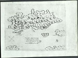
Cefalonia Insula
Verlag: Venice, 1571
"Cefalonia Insula .". Orig. copperplate engraving from G. F. Camocio's Isole Famose . Published in Venice by Camocio, 1571. With title-cartouche. 15,5:21 cm (6 1/4 x 8 1/4 inch.). Zacharakis: A catalogue of printed maps of Greece 1477-1800, 2nd edition, 1992; map nr. 509. - First state of the plate, without the number in the lower right corner. - A rare map of Cephalonia or Kefalonia, formerly also known as Kefallinia or Kephallenia, the largest of the Ionian Islands in western Greece. - Giovanni Francesco Camocio (1501-1575) was active as map publisher in Venice between 1558 and 1575. He was one of the most important mapmakers of the La Freri-school.
-
Cefalonia Insula
Verlag: Venice, 1571
Kefalonia (Greece)."Cefalonia Insula .". Orig. copperplate engraving from G. F. Camocio's Isole Famose . Published in Venice by Camocio, 1571. With title-cartouche. 15,5:21 cm (6 1/4 x 8 1/4 inch.). Zacharakis: A catalogue of printed maps of Greece 1477-1800, 2nd edition, 1992; map nr. 509. - First state of the plate, without the number in the lower right corner. - A rare map of Cephalonia or Kefalonia, formerly also known as Kefallinia or Kephallenia, the largest of the Ionian Islands in western Greece. - Giovanni Francesco Camocio (1501-1575) was active as map publisher in Venice between 1558 and 1575. He was one of the most important mapmakers of the La Freri-school.
-
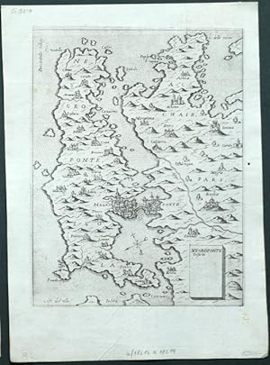
Negroponte Insula
Verlag: Venice, 1571
"Negroponte Insula". Orig. copperplate engraving from G. F. Camocio's Isole Famose . Published in Venice by Camocio, 1571. With title-cartouche. 20,5:16 cm (8 x 6 1/4 inch.). Zacharakis: A catalogue of printed maps of Greece 1477-1800, 2nd edition, 1992; map nr. 518. - First state of the plate, without the number in the lower right corner. - A rare map of Euboea, a Greek island in the Aegean Sea. Oriented to the Southeast. - Giovanni Francesco Camocio (1501-1575) was active as map publisher in Venice between 1558 and 1575. He was one of the most important mapmakers of the La Freri-school.
-

Negroponte Insula
Verlag: Venice, 1571
Euboea (Greece)."Negroponte Insula". Orig. copperplate engraving from G. F. Camocio's Isole Famose . Published in Venice by Camocio, 1571. With title-cartouche. 20,5:16 cm (8 x 6 1/4 inch.). Zacharakis: A catalogue of printed maps of Greece 1477-1800, 2nd edition, 1992; map nr. 518. - First state of the plate, without the number in the lower right corner. - A rare map of Euboea, a Greek island in the Aegean Sea. Oriented to the Southeast. - Giovanni Francesco Camocio (1501-1575) was active as map publisher in Venice between 1558 and 1575. He was one of the most important mapmakers of the La Freri-school.
-
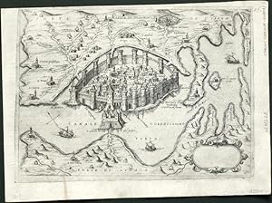
Citta di Negroponte
Verlag: Venice, 1571
Chalcis."Citta di Negroponte". Orig. copperplate engraving from G. F. Camocio's Isole Famose . Published in Venice by Camocio, 1571. With title-cartouche, ornamental cartouche (blank) and 3 ships. 16,5:23 cm (6 1/2 x 9 inch.). First state of the plate, without the number in the lower right corner. - A rare birds-eye-view of Chalcis or Chalkida, a chief town of the island of Euboea in Greece. Oriented to the Northeast. - Giovanni Francesco Camocio (1501-1575) was active as map publisher in Venice between 1558 and 1575. He was one of the most important mapmakers of the La Freri-school.
-
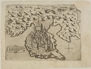
Napoli Citta nella Provincia della Morea
Verlag: Venice, 1571
Nafplio."Napoli Citta nella Provincia della Morea". Orig. copperplate engraving from G. F. Camocio's Isole Famose . Published in Venice by Camocio, 1571. With title-cartouche and many ships. 16:20 cm (6 1/4 x 8 inch.). First state of the plate, without the number in the lower right corner. - A rare birds-eye-view of Nafplio, a seaport town in the Peloponnese in Greece. - Giovanni Francesco Camocio (1501-1575) was active as map publisher in Venice between 1558 and 1575. He was one of the most important mapmakers of the La Freri-school.
-
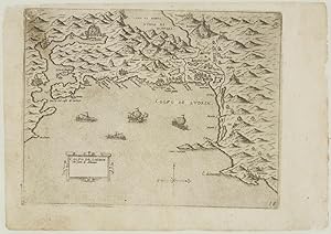
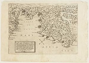
Colfo de Lodrin con parte Albania.
Erscheinungsdatum: 1575
Anbieter: Altea Antique Maps, London, Vereinigtes Königreich
Verbandsmitglied: ABA ILAB PBFA
Bewertung:
Karte
No Binding. Zustand: Very Good. Venice: Ferrando and/or Donato Bertelli, c.1575. 160 x 210mm. Slight surface rubbing top left. Map of the Balkan coast from Herceg-Novi in Montenegro to Durrës in Albania, marking Kotor. It was published in Camocio's 'Isole famose, porti fortezze e terre marittime sottoposte alla Ser.ma Sig.ria di Venezia', a description of the places claimed as subject to the Republic of Venice. A later state, with plate number.
-
Tine insula
Verlag: Venice, 1571
"Tine insula .". Orig. copperplate engraving from G. F. Camocio's Isole Famose . Published in Venice by Camocio, 1571. With ornamental title-cartouche and many ships. 16:20,5 cm (6 1/4 x 8 inch.). Zacharakis: A catalogue of printed maps of Greece 1477-1800, 2nd edition, 1992; map nr. 516. - First state of the plate, without the number in the lower right corner. - A rare map of Tinos, a Greek island situated in the Aegean Sea. - Giovanni Francesco Camocio (1501-1575) was active as map publisher in Venice between 1558 and 1575. He was one of the most important mapmakers of the La Freri-school.
-
Tine insula
Verlag: Venice, 1571
Tinos (Greece)."Tine insula .". Orig. copperplate engraving from G. F. Camocio's Isole Famose . Published in Venice by Camocio, 1571. With ornamental title-cartouche and many ships. 16:20,5 cm (6 1/4 x 8 inch.). Zacharakis: A catalogue of printed maps of Greece 1477-1800, 2nd edition, 1992; map nr. 516. - First state of the plate, without the number in the lower right corner. - A rare map of Tinos, a Greek island situated in the Aegean Sea. - Giovanni Francesco Camocio (1501-1575) was active as map publisher in Venice between 1558 and 1575. He was one of the most important mapmakers of the La Freri-school.
-
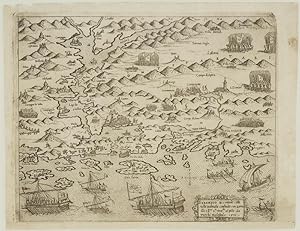
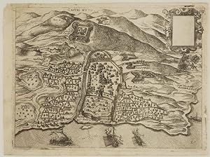
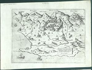
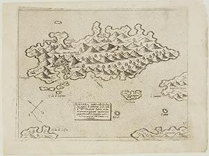
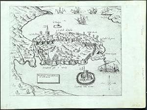
Sebenico et contado citta nella Dalmatia.
Erscheinungsdatum: 1575
Anbieter: Altea Antique Maps, London, Vereinigtes Königreich
Verbandsmitglied: ABA ILAB PBFA
Bewertung:
Karte
No Binding. Zustand: Very Good. Venice: Ferrando and/or Donato Bertelli, c.1575. 175 x 220mm. . A map of the environs of Siibenik under the threat of invading Turks, 1571, with vignette scenes of armies and galleys. This plan was published in Camocio's 'Isole famose, porti fortezze e terre marittime sottoposte alla Ser.ma Sig.ria di Venezia', a description of the places claimed as subject to the Republic of Venice. A later state, with plate number.
-
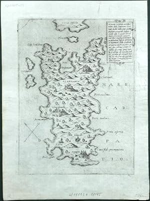
Scarapanto Carpanto Insula
Verlag: Venice, 1571
Karpathos (Greece)."Scarapanto Carpanto . Insula .". Orig. copperplate engraving from G. F. Camocio's Isole Famose . Published in Venice by Camocio, 1571. With ornamental title-cartouche. 20,5:15 cm (8 x 6 inch.). Zacharakis: A catalogue of printed maps of Greece 1477-1800, 2nd edition, 1992; map nr. 525. - First state of the plate, without the number in the lower right corner. - A rare map of Karpathos, one of the Greek Dodecanese islands, in the southeastern Aegean Sea. Oriented to the Northeast. - Giovanni Francesco Camocio (1501-1575) was active as map publisher in Venice between 1558 and 1575. He was one of the most important mapmakers of the La Freri-school.
-

Scarapanto Carpanto Insula
Verlag: Venice, 1571
"Scarapanto Carpanto . Insula .". Orig. copperplate engraving from G. F. Camocio's Isole Famose . Published in Venice by Camocio, 1571. With ornamental title-cartouche. 20,5:15 cm (8 x 6 inch.). Zacharakis: A catalogue of printed maps of Greece 1477-1800, 2nd edition, 1992; map nr. 525. - First state of the plate, without the number in the lower right corner. - A rare map of Karpathos, one of the Greek Dodecanese islands, in the southeastern Aegean Sea. Oriented to the Northeast. - Giovanni Francesco Camocio (1501-1575) was active as map publisher in Venice between 1558 and 1575. He was one of the most important mapmakers of the La Freri-school.
-
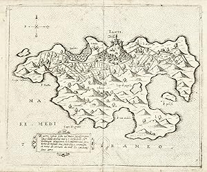
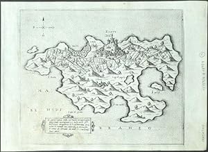
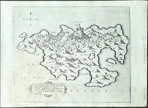
Istria sotto il dominio veneto.
Erscheinungsdatum: 1575
Anbieter: Altea Antique Maps, London, Vereinigtes Königreich
Verbandsmitglied: ABA ILAB PBFA
Bewertung:
Karte
No Binding. Zustand: Good. Venice: Ferrando and/or Donato Bertelli, c.1575. 180 x 235mm. Map of Istria showing from Caorle in Veneto, past Trieste in Slovenia to Pula in Croatia. Engraved in 1571, it was published in Camocio's 'Isole famose, porti fortezze e terre marittime sottoposte alla Ser.ma Sig.ria di Venezia', a description of the places claimed as subject to the Republic of Venice. A later state, with plate number.
-
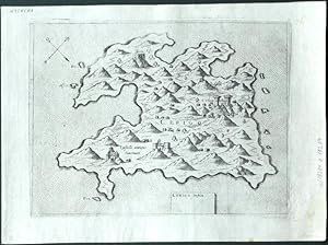
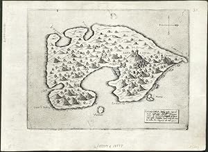
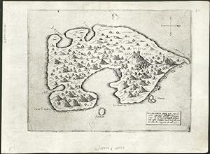
Liesena Insula nella Dalmatia
Verlag: Venice, 1571
Hvar (Croatia)."Liesena Insula nella Dalmatia". Orig. copperplate engraving from G. F. Camocio's Isole Famose . Published in Venice by Camocio, 1571. With title-cartouche. 16:21 cm (6 1/4 x 8 1/4 inch.). First state of the plate, without the number in the lower right corner. - A rare map of Hvar, a Croatian island in the Adriatic Sea. - Giovanni Francesco Camocio (1501-1575) was active as map publisher in Venice between 1558 and 1575. He was one of the most important mapmakers of the Lafreri-school.