
Gesamtpreis (1 Artikel Artikel):
Versandziel:

JANSSONIUS JOANNES (84 Ergebnisse)
Direkt zu den wichtigsten Suchergebnissen
Produktart
- Alle Produktarten
- Bücher (20)
- Magazine & Zeitschriften
- Comics
- Noten
- Kunst, Grafik & Poster (35)
- Fotografien
- Karten (29)
-
Manuskripte &
Papierantiquitäten
Zustand
Einband
Weitere Eigenschaften
- Erstausgabe (3)
- Signiert
- Schutzumschlag
- Angebotsfoto (52)
- Kein Print-on-Demand (81)
Gratisversand
Land des Verkäufers
Verkäuferbewertung
-
Zustand: New.
Mehr Angebote von anderen Verkäufern bei AbeBooks
Neu ab EUR 24,82
-
![Bild des Verkäufers für Polybiou tou Lykorta Megalopolitou Historion ta sozomena] = Polybii Lycortć F. Megalopolitani Historiarum libri qui supersunt Volume 3 [LeatherBound] zum Verkauf von True World of Books](https://pictures.abebooks.com/inventory/md/md31533123909.jpg)
LeatherBound. Zustand: New. LeatherBound edition. Condition: New. Reprinted from 1670 edition. Leather Binding on Spine and Corners with Golden leaf printing on spine. Bound in genuine leather with Satin ribbon page markers and Spine with raised gilt bands. A perfect gift for your loved ones. NO changes have been made to the original text. This is NOT a retyped or an ocr'd reprint. Illustrations, Index, if any, are included in black and white. Each page is checked manually before printing. As this print on demand book is reprinted from a very old book, there could be some missing or flawed pages, but we always try to make the book as complete as possible. Fold-outs, if any, are not part of the book. If the original book was published in multiple volumes then this reprint is of only one volume, not the whole set. Sewing binding for longer life, where the book block is actually sewn (smythe sewn/section sewn) with thread before binding which results in a more durable type of binding. Pages: 560 Volume 3 Language: Latin.
-

De origine bonorum possessionis, ejusque vi in adjuvando supplendo jure Romanorum hereditario. Dissertation.
Verlag: Groningen, 1859
Anbieter: Wissenschaftliches Antiquariat Köln Dr. Sebastian Peters UG, Köln, Deutschland
Bewertung:

Erstausgabe
Papiereinband. Zustand: moderat. X, 148 S., 24 cm, unaufgeschnitten, alter Papiereinband fleckig und am Rücken stark eingerissen, gebräunt, Inhalt gut erhalten. Sprache: Latin Erstausgabe.
-
![Bild des Verkäufers für Polybiou tou Lykorta Megalopolitou Historion ta sozomena] = Polybii Lycortć F. Megalopolitani Historiarum libri qui supersunt Volume 2 [LeatherBound] zum Verkauf von True World of Books](https://pictures.abebooks.com/inventory/md/md31533115850.jpg)
LeatherBound. Zustand: New. LeatherBound edition. Condition: New. Reprinted from edition. Leather Binding on Spine and Corners with Golden leaf printing on spine. Bound in genuine leather with Satin ribbon page markers and Spine with raised gilt bands. A perfect gift for your loved ones. NO changes have been made to the original text. This is NOT a retyped or an ocr'd reprint. Illustrations, Index, if any, are included in black and white. Each page is checked manually before printing. As this print on demand book is reprinted from a very old book, there could be some missing or flawed pages, but we always try to make the book as complete as possible. Fold-outs, if any, are not part of the book. If the original book was published in multiple volumes then this reprint is of only one volume, not the whole set. Sewing binding for longer life, where the book block is actually sewn (smythe sewn/section sewn) with thread before binding which results in a more durable type of binding. Pages: 930 Volume 2 Language: Latin.
-
![Bild des Verkäufers für Polybiou tou Lykorta Megalopolitou Historion ta sozomena] = Polybii Lycort F. Megalopolitani Historiarum libri qui supersunt Volume 1 (1670) [LeatherBound] zum Verkauf von True World of Books](https://pictures.abebooks.com/inventory/md/md31657499264.jpg)
LeatherBound. Zustand: New. LeatherBound edition. Condition: New. Reprinted from 1670 edition. Leather Binding on Spine and Corners with Golden leaf printing on spine. Bound in genuine leather with Satin ribbon page markers and Spine with raised gilt bands. A perfect gift for your loved ones. NO changes have been made to the original text. This is NOT a retyped or an ocr'd reprint. Illustrations, Index, if any, are included in black and white. Each page is checked manually before printing. As this print on demand book is reprinted from a very old book, there could be some missing or flawed pages, but we always try to make the book as complete as possible. Fold-outs, if any, are not part of the book. If the original book was published in multiple volumes then this reprint is of only one volume, not the whole set. Sewing binding for longer life, where the book block is actually sewn (smythe sewn/section sewn) with thread before binding which results in a more durable type of binding. Pages: 942 Volume 1 Polybius,John Adams Library (Boston Public Library) MB (BRL),Aeneas, Tacticus, 4th cent. B.C,Casaubon, Isaac, 1559-1614, tr,Gronovius, Jacobus, 1645-1716, ed,Janssonius van Waesberge, Johannes, fl. 1642-1681, publisher,Someren, Joannes van, publisher,Mathijsz, Severijn, printer,Adams, John, 1735-1826, former owner.
-
Kein Einband. Zustand: Gut. 36 x 46,5 cm gefaltete Landkarte, mit Mittelfalz, Papier altersbedingt etwas fleckig und gebräunt, Rand mit kleineren Einrissen, rechte untere Randecke etwas wasserrandig, sonst GUTES EXEMPLAR---Mit 2 farbigen Kartuschen und einem kolorierten Stadtplan von Nürnberg. Rückseite mit Text. Blatt: 49 x 57 cm , 1 Seiten. nein.
-

Pas de couverture. Zustand: Trčs bon. Carte in plano (55 X 42,5 cm). Beau cartouche soutenu par des anges ailés avc les armes de l'artois. Au dos texte en espagnol de l'ouvrage "Nuevo Atlas, o Teatro de Todo el Mundo de Juan Janssonio en el qual con gran Cuydado Se Proponen los Mapas y Descripciones de Todo el Universo,".
-

Zustand: -. Gefaltete Kupferstich-Karte mit alt kolorierter Kartusche und Grenzkolorit. Blattmaß: 58 x 48 cm. Mit kleinem Riss in der Knickfalte im unterem Rand. Stärker gebräunt. Fotos gerne auf Anfrage!.
-

Le Diocese de Sarlat" - Sarlat-la-Caneda Bergerac Dordogne Nouvelle-Aquitaine Karte map carte gravure
Verlag: Amsterdam, Johannes Janssonius ca. 1650., 1650
Anbieter: Antiquariat Steffen Völkel GmbH, Seubersdorf, Deutschland
Bewertung:
Karte
Seltene altkolorierte Kupferstich-Karte von ca. 1650. -- Mit lateinischem Text auf der Rückseite. -- Blatt-Maße: ca. 49 x 58 cm. -- unten im Mittelbug teils etwas eingerissen (außerhalb der Karte), teils leicht fleckig, sonst gut erhalten. || Rare old colored engraved map from c. 1650. Rare early state of this map with the lion-cartouche. With Latin text on verso. -- partly split on the lower part of the centerfold, partly slightly stained, otherwise in good condition. || Dies ist ein Original! - Kein Nachdruck! - Keine Kopie! -- This is an original! - No copy! - No reprint! la Gewicht in Gramm: 1550.
-
NAVARRA.
Verlag: Ed. Joannis Janssony. Amstelodami, s.a. (c.1650, 1650
Anbieter: Libreria Anticuaria Farré, Barcelona, BARCE, Spanien
Bewertung:
). 53 x 59,5 cm. Mínima rasgadura. Navarra.
-
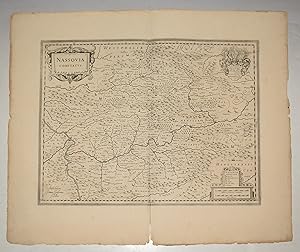
Original Engraved Antique Map of Nassovia Comitatus (County of Nassau.) Map shows Nordrhein-Westfalen with Siegen Rheinlandpfalz with Koblenz and Hessen with Wiesbaden.
Verlag: Amsterdam No date 1650, 1650
Anbieter: PROCTOR / THE ANTIQUE MAP & BOOKSHOP, DORCHESTER, Vereinigtes Königreich
Verbandsmitglied: PBFA
Bewertung:
Unmounted. Size 21 x 25 inches. Decorative Antique map With two orig. ornamental cartouches and large orig. Coat of arms. Shows Westerwald and Taunus with the Lahn river area (from Lollar to Lahnstein) in the center. In very good condition. A few faint marks on margins, and a couple of slight nicks. Inch split lower centre fold margin. Uncoloured,
-
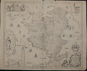
Denmark: "Selandić In Regno Danić Insulć Chorographica Descriptio"
Verlag: Joannes Janssonius, Amsterdam, 1645
Karte
Zustand: Fair (see description). copper engraved map, 44.5 cms (17.5 ins) x 53 cms (21 ins), uncoloured, a detailed study of the Danish Region of Sjaellanda with Kiobenhafven (Kopenhaven) on the east and Fionae (Fyn) on West, central fold as issued and an additional lateral central fold, ownership stamp, a few pinprick holes, a couple of larger holes and splits along folds in places, marginal nicks etc in places, some light pencil lines, Overall fair condition for age. This is an original antique map. We do not sell reproductions or facsimiles.
-
ducato di Parma et di Piacenza.
Verlag: Amsterdam c., 1650
Anbieter: Robert Frew Ltd. ABA ILAB, London, Vereinigtes Königreich
Verbandsmitglied: ABA ILAB PBFA
Bewertung:
Karte
Original hand-coloured engraved map (38 x 49 cm, overall sheet 49 x 57 cm.), latin text on verso. Short splits in margin of centre-fold.
-
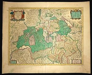
Helvetiae Rhetiae & Valesiae cum omnibus finitimis regionibus tabula vulgo Schweitzerland.
Verlag: Amsterdam, Johannes Janssonius. (Zwischen 1640 und 1670)., 1670
Blattgrösse: 51,5x62 cm. Gestochene kolorierte Karte (41x52,5 cm) Blumer 103. - Haller 114. - Sammlung Ryhiner 3202.22. - Titelkartusche oben links, weitere Kartuschen oben rechts, unten links (Legende) und unten rechts (Massstab). - Auf neue Leinwand aufgezogen. Linker Rand ausserhalb der Platte fachgerecht restauriert. Sprache: n.
-
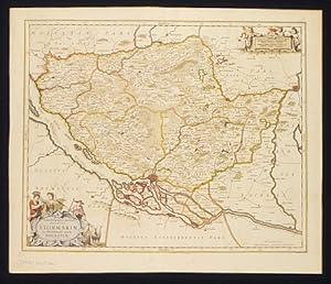
Tabula Geagraphica. Ducatus Stormariae. Tabula Geagraphica novissima Ducatus Stormariae in Meridionali parte Holsatiae.
Verlag: Amsterdam, 1658
Anbieter: Shapero Rare Books, London, Vereinigtes Königreich
Verbandsmitglied: ABA ILAB PBFA
Bewertung:

Karte
Double-page, engraved with fine original hand-colour. Attractive map by Jansson, showing the southern Duchy of Holstein in northern Germany. Central to the map is the historically important Hanseatic port of Hamburg. Decorative, rococo style embellishments complement this delightful map. 437 x 540 mm (17.25 x 21.25 inches). Koeman 1:428.1 (28c).
-
Bohemia
Verlag: Amsterdam, 1657
Anbieter: Alexandre Antique Prints, Maps & Books, Toronto, ON, Kanada
Bewertung:

Karte
Size : 400x460 (mm), 15.75x18.125 (Inches), Hand Colored Very Good; central fold reinforced.
-
Lionnois, Forest, Beaviolois et Masconnois.
Verlag: c.1640, Amsterdam, 1640
Anbieter: Alexandre Antique Prints, Maps & Books, Toronto, ON, Kanada
Bewertung:
Karte
Zustand: Very Good; Size : 372x488 (mm), 14.65x19.21 (Inches), Original Hand Coloring.
-
Lumen Historiarum per Occidentem.
Verlag: Amsterdam,, 1640
Anbieter: libreria antiquaria perini Sas di Perini, Verona, VR, Italien
Bewertung:
Kunst / Grafik / Poster
Incisione in rame, colorata ai confini, di mm 385x485. Tratta dal volume di geografia del mondo antico di Hoornius. Raffigura l'Europa antica. Buon esemplare, lavato, con cospicui restauri visibili in controluce.
-
Theatrum Exhibens Celebriores Galliae et Heelvetiae Urbes
Verlag: Amsterdam, 1620
Anbieter: Alexandre Antique Prints, Maps & Books, Toronto, ON, Kanada
Bewertung:
Karte
Size : 365x232 (mm), 14.375x9.125 (Inches), Original Hand Coloring Very Good; occasional browning spots; left margin extended.
-
Sicilia Regnum [Sizilien]. Teilkolorierter Kupferstich aus dem "Atlas Contractus Sive Mapparum Geographicarum Sansoniarum Auctarum und Correctarum Nova Congeries .". Das ist bei diesem Blatt ein unveränderter Nachdruck aus dem legendären Atlasses von Janssonius aus den Jahren 1644-1680.Plattengröße 40 x 49,5 cm, Blattgröße 48,3 x 59,6 cm.
Verlag: Amstelodami / Amsterdam: G Valk & P Schenk, 1700
Karte
[im weißen Rand etwas gebräunt und stockfleckig, im unteren weißen Rand drei kleine Fehlstellen, verso Reste einer ehemaligen Montage, der Mittelfalz, obwohl ohne Einrisse, unterlegt, sonst gutes, breitrandiges Exemplar]. 1850 gr.
-
Nova et accurata Tusciae antique descriptio autore Ab. Ortelio
Verlag: Amsterdam, 1650
Anbieter: libreria antiquaria perini Sas di Perini, Verona, VR, Italien
Bewertung:
Kunst / Grafik / Poster
Incisione in rame, dipinta a mano, incisa da Petrus Kaerius, mm 350x494. La prima edizione a stampa fu realizzata da Abraham Ortelius per il suo Parergon, il primo atlante storico mai concepito; successivamente una nuova lastra venne preparata da Janszon ed inserita nel volume del mondo antico (vol. VI) del suo Atlas Major e poi in "Accuratissima Orbis Antiqui Delineatio" col testo di G. Hornius, stampato come volume singolo. Ottime condizioni generali, ampi margini e lieve ingiallimento della carta.Janssonius, genero di Jodocus Hondius e cognato di Henricus Hondius, figlio di Jodocus, collaborÚ alla pubblicazione di atlanti, dopo l'acquisizione delle lastre di Mercatore da parte di Jodocus e dal 1638 fu in effetti colui che guidÚ l'impresa editoriale, mentre Henricus Hondius lentamente abbandonava l'attivit? (dal 1646 il suo nome non apparir? pi? su alcun frontespizio); divenne cosĎ il grande avversario della famiglia Blaeu nel secolo d'oro della cartografia olandese. Georg Horn fu un erudito tedesco, autore di numerose opere storiche, fra cui anche del testo per l'atlante storico di Janssonius.
-
Saltzburg archiepiscopatus cum ducatu Carinthiae.
Verlag: Amsterdam,, 1650
Anbieter: libreria antiquaria perini Sas di Perini, Verona, VR, Italien
Bewertung:
Kunst / Grafik / Poster
Incisione in rame, dipinta a mano d'epoca, 377x495. Bell' esemplare con qualche leggera traccia di umidit? Presenta una piccola crepa (percettibile solo in controluce) vicino alla giuntura delle due pagine. Nr.cat: 100_6864.
-

Chili
Verlag: Amsterdam, 1640
Anbieter: libreria antiquaria perini Sas di Perini, Verona, VR, Italien
Bewertung:
Kunst / Grafik / Poster
Incisione in rame, dipinta díepoca, mm 375x485. Piacevole carta del Cile arrichita da cartigli, rose dei venti e vascelli. Janssonius, dopo un periodo seguito allíacquisizione delle lastre di Mercatore da parte di Henricus Hondius dal padre Jodocus, fu colui che guidÚ líimpresa editoriale, dal 1646, quando il nome di Hondius non apparir? pi? su alcun frontespizio, sostituito sempre da quello di Janssonius; la societ? fra Hondius e Janssonius era stata il grande avversario della famiglia Blaeu nel secolo díoro della cartografia olandese, ma Janssonius sviluppÚ ulteriormente il suo Atlas Major in concorrenza coi fratelli Blaeus . Esemplare con foglio ossidato e qualche traccia di colore in controstampa, margine inferior un poco rifilato Nr.cat: Cod 2477.
-
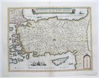
Natolia, quae olim Asia Minor.
Verlag: Amsterdam, 1620
Anbieter: Alexandre Antique Prints, Maps & Books, Toronto, ON, Kanada
Bewertung:
Karte
Zustand: Very Good; fold reinforced. Size : 388x503 (mm), 15.25x19.75 (Inches), Hand Colored.
-

Albis. Fluvius Germaniae celebris, a fontibus ad Ostia.
Verlag: Amsterdam, Joannem Janssonium, ca 1645., 1645
In-folio. Mit altem Grenzkolorit, 39 x 49 van der Krogt, Koemans Atlantes Neerlandici, 2070:1B.1. Klassische zweiteilige Karte des Flusslaufs der Elbe von der Quelle im Tschechischen Riesengebirge bis zu Mündung in die Nordsee. Gutes Exemplar.
-
Ducato di Ferrara.
Verlag: Amsterdam, 1630
Anbieter: libreria antiquaria perini Sas di Perini, Verona, VR, Italien
Bewertung:
Kunst / Grafik / Poster
Incisione in rame, colorata, 390x500. Janssonius fu in collaborazione con il cognato Henricus Hondius prima e successivamente dal 1638 da solo, il pi? importante concorrente dei Blaeu a cui ispirÚ ed uniformÚ la produzione, tanto da costringere Blaeu, anch'egli Jansson di cognome vero a scegliere uno pseudonimo per differenziare la propria produzione. Buon esemplare. Nr.cat: 1703.
-
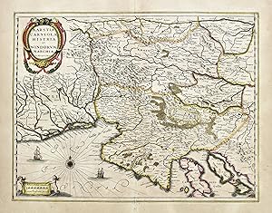
Karstia, Carniola, Histria et Windorum Marchia
Verlag: Amsterdam, 1650
Anbieter: libreria antiquaria perini Sas di Perini, Verona, VR, Italien
Bewertung:
Kunst / Grafik / Poster
Incisione in rame, colore d'epoca, mm 385x495. Tratta da "Atlas Novus" buon esemplare con qualche difetto alla piega centrale, carta leggermente brunita in modo uniforme. Janssonius, genero di Jodocus Hondius e cognato di Henricus, collaborÚ alla pubblicazione di atlanti, dopo l'acquisizione delle lastre di Mercatore da parte di Jodocus e dal 1638 fu in effetti colui che guidÚ l'impresa editoriale, mentre Henricus Hondius lentamente abbandonava l'attivit? (dal 1646 il suo nome non apparir? pi? su alcun frontespizio); risultÚ cosĎ divenire il grande avversario della famiglia Blaeu nel secolo d'oro della cartografia olandese. Copper engraving, hand color, mm 385x495. A classic map of Slovenia and Histria. General good condition, some defects at centerfold, uniform light paper oxidation. Johannes Janssonius (1588 - 1664) was born in Arnhem, Holland. He was the son of a printer and bookseller and in 1612 married the daughter of Hondius. In 1616 Jansson produced his first maps influenced by Blaeu. In the mid 1630s Jansson partnered with his brother-in-law, Henricus Hondius, to produce his important work, the eleven volume Atlas Major. About this time, Jansson's name also begins to appear on Hondius reissues of notable Mercator/Hondius atlases. Nr.cat: Cod 3928.
-
Ducato di Parma et di Piacenza
Verlag: Amsterdam, 1650
Anbieter: libreria antiquaria perini Sas di Perini, Verona, VR, Italien
Bewertung:
Kunst / Grafik / Poster
Incisione in rame, colorata d'epoca, 380x490. Jansson fu, in collaborazione con il cognato Henricus Hondius prima, e dal 1638 da solo, il pi? importante concorrente di Blaeu a cui ispirÚ ed uniformÚ la propria produzione, tanto da costringere il concorrente, anch'egli di cognome Jannson, a scegliere lo pseudonimo con cui ci Ë noto per differenziare la propria produzione. Qualche macchia, alcuni assotigliamenti della carta, piccoli restauri marginali e piccola menda al margine destro. Rinforzo in carta Cina alla piega centrale.
-
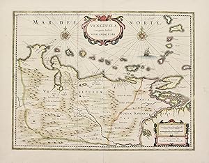
Venezuela cum parte Australi Novae Andalusiae
Verlag: Amsterdam, 1640
Anbieter: libreria antiquaria perini Sas di Perini, Verona, VR, Italien
Bewertung:
Kunst / Grafik / Poster
Incisione in rame, dipinta a mano d'epoca, mm 380x495; buon esemplare con restauro marginale alla piega centrale in basso e in alto. Bellissima coloratura antica con rialzi Dorati. Janssonius, genero di Jodocus Hondius e cognato di Henricus, collaborÚ alla pubblicazione di atlanti, dopo l'acquisizione delle lastre di Mercatore da parte di Jodocus e dal 1638 fu in effetti colui che guidÚ l'impresa editoriale, mentre Henricus Hondius lentamente abbandonava l'attivit? (dal 1646 il suo nome non apparir? pi? su alcun frontespizio); risultÚ cosĎ divenire il grande avversario della famiglia Blaeu nel secolo d'oro della cartografia olandese. Copper engraving, original hand colour, mm 380x495. A classic map of Venezuela. Good condition, restored tears at centerfold in margin at bottom and top, very decorative colour reinforced with gold. Johannes Janssonius (1588 - 1664) was born in Arnhem, Holland. He was the son of a printer and bookseller and in 1612 married the daughter of Hondius. In 1616 Jansson produced his first maps influenced by Blaeu. In the mid 1630s Jansson partnered with his brother-in-law, Henricus Hondius, to produce his important work, the eleven volume Atlas Major. About this time, Jansson's name also begins to appear on Hondius reissues of notable Mercator/Hondius atlases. Nr.cat: 6672.
-
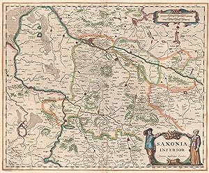
Saxonia inferior (recte: Fürstentum Lüneburg).
Verlag: Amsterdam ,, 1644
Anbieter: Antiquariat Ruthild Jäger, Lueneburg, Deutschland
Bewertung:

Kunst / Grafik / Poster Erstausgabe
Altkolor. Kupferstichkarte, 46 x 38 cm. Seltenes Blatt, gut erhalten. * Koeman Me 75A (erste Ausgabe). Die Karte zeigt entgegen ihrem Titel nicht Niedersachsen oder den Niedersächsischen Reichskreis, sondern das Territorium des Fürstentums Lüneburg zwischen Hamburg, Braunschweig und Nienburg, mit Nachbargebieten bis Glückstadt/Elbe, Lübeck, Wismar, Wolfenbüttel, Minden und Bremen; mit ornamentaler Maßstabkartusche und figürlicher Titelkartusche.


![Bild des Verkäufers für Sicilia Regnum [Sizilien]. Teilkolorierter Kupferstich aus dem "Atlas Contractus Sive Mapparum Geographicarum Sansoniarum Auctarum und Correctarum Nova Congeries .". Das ist bei diesem Blatt ein unveränderter Nachdruck aus dem legendären Atlasses von Janssonius aus den Jahren 1644-1680.Plattengröße 40 x 49,5 cm, Blattgröße 48,3 x 59,6 cm. zum Verkauf von Antiquariat Dr. Lorenz Kristen](https://pictures.abebooks.com/inventory/md/md30709921495.jpg)
