Gesamtpreis (1 Artikel Artikel):
Versandziel:

JANSSONIUS JOHANN (157 Ergebnisse)
Direkt zu den wichtigsten Suchergebnissen
Produktart
- Alle Produktarten
- Bücher (127)
- Magazine & Zeitschriften
- Comics
- Noten
- Kunst, Grafik & Poster (6)
- Fotografien
- Karten (24)
-
Manuskripte &
Papierantiquitäten
Zustand
Einband
Weitere Eigenschaften
- Erstausgabe (1)
- Signiert (5)
- Schutzumschlag
- Angebotsfoto (156)
- Kein Print-on-Demand (156)
Gratisversand
Land des Verkäufers
Verkäuferbewertung
-
![Bild des Verkäufers für Freuden-Bezeugung der Stadt Dantzig : über die höchst-erwünschte königliche Wahl und darauf glücklich-erfolgte Krönung des durchläuchtigsten, grossmächtigsten Fürsten und Herrn, Herrn Augusti des Andern, Königes in Pohlen . : wobey höchst-gedachter Majestät königlicher Einzug in besagte Stadt, die daselbst aufgerichtete Ehre-Pforten, Huldigungs-Actus, gehaltenes Feuerwerck, und was sonsten denckwürdiges vorgefallen, biss an Dero Königlichen Abzug, wahrhafftig beschrieben, und alles in schönen Kupfferen repraesentiret wird [LeatherBound] zum Verkauf von True World of Books](https://pictures.abebooks.com/inventory/md/md31533277904.jpg)
Freuden-Bezeugung der Stadt Dantzig : über die höchst-erwünschte königliche Wahl und darauf glücklich-erfolgte Krönung des durchläuchtigsten, grossmächtigsten Fürsten und Herrn, Herrn Augusti des Andern, Königes in Pohlen . : wobey höchst-gedachter Majestät königlicher Einzug in besagte Stadt, die daselbst aufgerichtete Ehre-Pforten, Huldigungs-Actus, gehaltenes Feuerwerck, und was sonsten denckwürdiges vorgefallen, biss an Dero Königlichen Abzug, wahrhafftig beschrieben, und alles in schönen Kupfferen repraesentiret wird [LeatherBound]
Erscheinungsdatum: 2023
Buch Print-on-Demand
LeatherBound. Zustand: New. LeatherBound edition. Condition: New. Reprinted from 1698 edition. Leather Binding on Spine and Corners with Golden leaf printing on spine. Bound in genuine leather with Satin ribbon page markers and Spine with raised gilt bands. A perfect gift for your loved ones. NO changes have been made to the original text. This is NOT a retyped or an ocr'd reprint. Illustrations, Index, if any, are included in black and white. Each page is checked manually before printing. As this print on demand book is reprinted from a very old book, there could be some missing or flawed pages, but we always try to make the book as complete as possible. Fold-outs, if any, are not part of the book. If the original book was published in multiple volumes then this reprint is of only one volume, not the whole set. Sewing binding for longer life, where the book block is actually sewn (smythe sewn/section sewn) with thread before binding which results in a more durable type of binding. Pages: 94 Language: German.
-
Britannia prout divisa suit temporibus Anglo-Saxonum, praesertim durante illorum Heptarchia.
Anbieter: Little Stour Books PBFA Member, Canterbury, Vereinigtes Königreich
Verbandsmitglied: PBFA
Bewertung:

Coloured facsimile reprint of the original authentic map of England, Scotland and Wales on reflective gold card stock. 16'' x 20''. Map shows England, Scotland and Wales with decorative side borders each comprising vignettes depicting Anglo-Saxon Kings. In Fine condition. Sent rolled in a tube. Member of the P.B.F.A. CARTOGRAPHY, MAPS, PLANS.
-
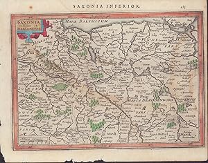
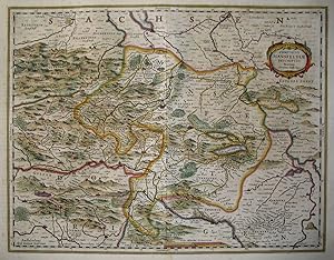
Saxonia Inferior et Meklenborg. -
Verlag: [Um 1630]., 1630
Kunst / Grafik / Poster
Kupferstich 14,5 x 20,5 cm, Blattgröße 17,5 x 22 cm. Die Landkarte von Janssonius zeigt mittig Mecklenburg, dazu im Westen das Herzogtum Lauenburg und Lüneburg, am unteren Blattrand Teile der Altmark und als östliche Begrenzung Vorpommern. Oben links eine kleine Kartusche, unten links ein Meilenanzeiger. - Johann Janssonius 1588 - 1664, niederländischer Kartograph und Verleger. - Am rechtem Blattrand leicht wasserrandig.
-
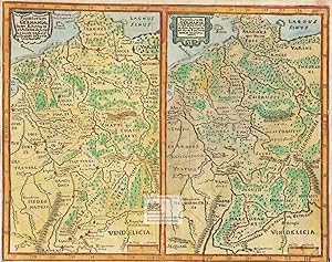
Populorum Germaniae inter Rhenum et Albim descriptio. Zwei Landkarten Germaniens zwischen Rhein und Elbe während der Regentschaft von Cäsar und Trajan. Altkolorierter Kupferstich bei Janssonius nach Clüwer um 1660
Verlag: Amsterdam: Johannes Janssonius um, 1660
Anbieter: historicArt Antiquariat & Kunsthandlung, Wiesbaden-Breckenheim, Deutschland
Bewertung:
Karte Erstausgabe
1. Original-Kupferstich auf rückseitig unbedrucktem Büttenblatt mit zwei nebeneinander liegenden Karten mit Meilenzeiger, von alter Hand prächtig flächenkoloriert, Blattgröße ca. 21 x 26,5 cm, am linken Blattrand außerhalb der bildlichen Darstellung knapp beschnitten, einzelne Tafel aus dem Werk "Introductionis in Universam Geographiam tam veterem quam novam Libri", sehr gut erhalten, sehr selten und für uns anderenorts antiquarisch nicht nachweisbar 2100 gr.
-
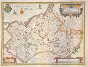
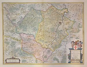
AN ORIGINAL ENGRAVED MAP OF Herefordshire. Herefordia Comitatus vernacule Hereford Shire
Verlag: Atlas Novus Ca 1690, 1690
Anbieter: PROCTOR / THE ANTIQUE MAP & BOOKSHOP, DORCHESTER, Vereinigtes Königreich
Verbandsmitglied: PBFA
Bewertung:
Karte
Lg.map (engr.surface 20.5 x 15.5 inches). In ivory mount. Black & Gilt glazed frame. Framed Size 28 x 23 inches An attractive and decorative map in very good condition. Nicely Original hand-coloured. he map has a decorative cartouche, illustrations of various coats of arms and cherubs in the top right corner and cherubs and a man making use of the measurement legend in the bottom left corner. Jan Jansson Jr (1588-1664), or Johannes Janssonius, was the son of a bookseller and publisher who had worked with Jodocus Hondius Sr. From about 1633 onwards, his imprint appears on the title-pages of the Mercator-Hondius "Atlas", in conjunction with his brother-in-law, Henry, as they re-issued their "Atlas" in competition with the Blaeus.
-

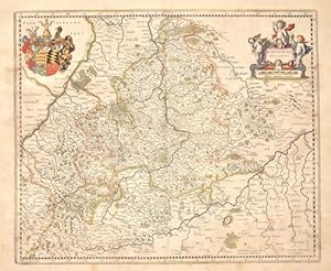
Episcopatus Hildesiensis." - Hildesheim Niedersachsen Karte map
Verlag: Oxford, Janssonius-Waesberg / Pitt / Swart um 1680., 1680
Anbieter: Antiquariat Steffen Völkel GmbH, Seubersdorf, Deutschland
Bewertung:
Karte
Original altkolorierte Kupferstich-Karte. -- Gutes Exemplar in seltenem Original-Verlagskolorit. -- Ohne Rückentext. -- Blatt-Maße: ca. 60 x 50,5 cm. -- gut erhalten. || Original old colored engraved map. -- In very good condition, with the rare original publishing coloring. -- Without text on verso. -- in good condition.|| Dies ist ein Original! - Kein Nachdruck! - Keine Kopie! -- This is an original! No copy! - No reprint! la Gewicht in Gramm: 1550.
-
Kein Einband. Zustand: Gut. Es handelt sich hierbei um eine originale, kolorierte Kupferstich-Landkarte des Gebiets der Grafschaft Mansfeld von Johann Janssonius (1588 - 1664) aus dem Jahr 1650. *** Titel: Comitatus Mansfeldiae Descriptio *** Gebiet bzw. Ort: Grafschaft Mansfeld am Südharz *** Kartograph: Johann Janssonius (1588 - 1664) *** Jahr: 1650 *** Größe des Plattenbereichs: *** Technik: Kupferstich *** Zustand (Perfekt/ Sehr gut/ Gut/ Ordentlich/ Mäßig/ Schlecht): In gutem Erhaltungszustand *** Bemerkungen: - - - - International buyers welcome. If you have any questions, please don't hesitate to ask. --- Auf Wunsch stellen wir Ihnen gerne ein kostenfreies Echtheitszertifikat aus --- If you wish, we will gladly provide a certificate of authenticity free of charge ---.
-
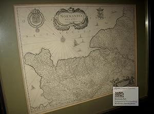
Normandia ducatus. Antique Map. Normandie mit Titelkartusche, Segelschiffen und Meerungeheuern im Atlantik. Original-Kupferstich von Johann Janssonius um 1640
Verlag: Amsterdam: Johannes Janssonius um, 1640
Anbieter: historicArt Antiquariat & Kunsthandlung, Wiesbaden-Breckenheim, Deutschland
Bewertung:
Karte Signiert
1. große Kupferstich-Landkarte von Johann Janssonius (in der Platte signiert) mit Titelkartusche und Wappen oben links, im Atlantik Segelschiffe und Meeresungeheuer, rechts unten germanischer und gallischer Meilenzeiger in Rollwerk, das von zwei geflügelten Putti mit Globen gehalten wird, bildliche Darstellung ca. 37 x 51 cm, sauber und bemerkenswert gut erhalten, selten 2100 gr.
-
Lumen Historiarum. Per Orientem, illustrandes Biblys.
Verlag: Artist: Janssonius/Kaerius Johann ( - 1664 ) Amsterdam; issued in: Amsterdam; Janssonius/Kaerius Johann ( 1588 - 1664 ) Amsterdam; Johannes Janssonius (Jansson)( 1588- 1664) Amsterdam was born in Arnhem the son of Jan Janszoon the Eldera publisher and bookseller In 1612 he married Elisabeth de Hondt the daughter of Jodocus Hondius He produced his first maps in 1616 of France and Italy In 1623 Janssonius owned a bookstore in Frankfurt am Main later also in Danzig Stockholm Copenhagen Berlin Königsberg Geneva and Lyon In the 1630s he formed a partnership with his brother in law Henricus Hondius and together they published atlases as Mercator/Hondius/Janssonius Under the leadership of Janssonius the Hondius Atlas was steadily enlarged Renamed, 1588
Anbieter: Antique Sommer& Sapunaru KG, München, Deutschland
Bewertung:

Technic: Copper print; colorit: original colored; condition: Missing part at center perfectly replaced, Wormholes restored; size (in cm): 38 x 47; Map shows total Turkey with Cyprus, on inset map the Holy Land. History: Western Asia, is the westernmost subregion of Asia with the following countries: Egypt (Peninsula Sinai only), Bahrain, Iran, Iraq, Israel, Jordan, Kuwait, Lebanon, Oman, Qatar, Palestinian territories (called West Bank and Gaza in the latter), Saudi Arabia, Syria, Turkey, UAE, Turkey, Georgia, Cyprus and Yemen.The concept is in limited use, as it significantly overlaps with the Middle East (or the Near East), the main difference usually being the exclusion of the majority of Egypt (which would be counted as part of North Africa) and the inclusion of the Caucasus. As a geographic concept, Western Asia includes the Levant, Mesopotamia, Anatolia, Iran, the Armenian Highlands, the South Caucasus, the Arabian peninsula as well as the Sinai Peninsula, making Egypt a transcontinental country.
-
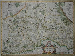
Kein Einband. Zustand: Gut. Es handelt sich hierbei um eine originale Kupferstich-Landkarte der Oberpfalz von Johann Janssonius (1588 - 1664) aus dem Jahr 1664. *** Titel: Palatinatus Bavariae *** Gebiet bzw. Ort: Oberpfalz nördlich der Donau, zwischen Straubing und Regensburg im Süden, Nürnberg im Westen, Pegnitz im Norden und dem Böhmerwald im Osten. *** Kartograph: Johann Janssonius (1588 - 1664) *** Jahr: 1664 *** Größe des Plattenbereichs: 38 x 46 cm *** Technik: Kupferstich *** Zustand (Perfekt/ Sehr gut/ Gut/ Ordentlich/ Mäßig/ Schlecht): In gutem Erhaltungszustand. Im Randbereich kleiner Fleck. *** Bemerkungen: Eine sehr dekorativ kolorierte Karte der Oberpfalz nördlich der Donau, zwischen Straubing und Regensburg im Süden, Nürnberg im Westen, Pegnitz im Norden und dem Böhmerwald im Osten. Aus 'Nouvel Atlas' bei Johannes Janssonius. Verso französischer Text. - - - International buyers welcome. If you have any questions, please don't hesitate to ask. --- Auf Wunsch stellen wir Ihnen gerne ein kostenfreies Echtheitszertifikat aus --- If you wish, we will gladly provide a certificate of authenticity free of charge ---.
-
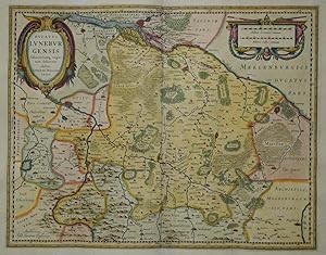
Kein Einband. Zustand: Gut. Es handelt sich hierbei um eine originale, altkolorierte Kupferstich-Landkarte des Herzogtums Lüneburg von Johann Janssonius (1588 - 1664) aus dem Jahr 1640. *** Titel: Ducatus Luneburgensis Adiacentiumq regionum delineatio *** Gebiet bzw. Ort: Herzogtum Lüneburg *** Kartograph: Johann Janssonius (1588 - 1664) *** Jahr: ca. 1640 *** Größe des Plattenbereichs: 38 x 49 cm *** Technik: Kupferstich *** Zustand (Perfekt/ Sehr gut/ Gut/ Ordentlich/ Mäßig/ Schlecht): In gutem Erhaltungszustand. Insgesamt altersgemäß leicht gebräunt. *** Bemerkungen: Eine sehr detaillierte Karte des Herzogtums Lüneburg in dekorativem Altkolorit. Der Kartenbereich umfasst das Gebiet zwischen Hamburg im Norden, Magdeburg im Osten, Hildesheim im Süden und Diepholz / Bremen im Westen. - - - International buyers welcome. If you have any questions, please don't hesitate to ask. --- Auf Wunsch stellen wir Ihnen gerne ein kostenfreies Echtheitszertifikat aus --- If you wish, we will gladly provide a certificate of authenticity free of charge ---.
-
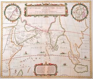
Erythraei Sive Rubri Maris Periplus.
Verlag: Artist: Janssonius Johann ( - 1664 ) Amsterdam; issued in: Amsterdam; Janssonius Johann ( 1588 - 1664 ) Amsterdam; Johannes Janssonius (Jansson)( 1588- 1664) Amsterdam was born in Arnhem the son of Jan Janszoon the Elder a publisher and bookseller In 1612 he married Elisabeth de Hondt the daughter of Jodocus Hondius He produced his first maps in 1616 of France and Italy In 1623 Janssonius owned a bookstore in Frankfurt am Main later also in Danzig Stockholm Copenhagen Berlin Königsberg Geneva and Lyon In the 1630s he formed a partnership with his brother in law Henricus Hondius and together they published atlases as Mercator/Hondius/Janssonius Under the leadership of Janssonius the Hondius Atlas was steadily enlarged Renamed Atlas Novus it, 1588
Anbieter: Antique Sommer& Sapunaru KG, München, Deutschland
Bewertung:
Technic: Copper print; colorit: colored; condition: Lower center, missing part replaced, some text is missing; size (in cm): 39 x 46; Map shows the Indian Ocean from Egypt and the red sea with Arabia, with India, Thailand to Jave. The map has been copied from the original projection of Abraham Ortelius from 1595. History: In the first centuries after the turn of the times, Indian traders spread their culture over large parts of Southeast Asia. The Kingdom of Funan (200-550) in the Mekong Delta developed into the first center of Hinduism and Buddhism in Southeast Asia. It was replaced by the Khmer Kingdom and the Srivijaya Empire in Sumatra. 750 Borobodur was built on Java, a terraced temple complex of enormous size. The Khmer kings created an equally impressive work of art with the construction of their Angkor Wat temple complex. From the 9th century, the Tai migrated from the north to their present-day settlement areas and met the high-ranking Mon, whose culture they shaped. In 1044 the first Burmese Empire was founded with Bagan as the capital. In Southeast Asia, extensive trade had developed from the 6th to the 16th century, numerous shipwrecks testify to this development, such as that of the Lena Shoal junk. The ship types of the junk and the balangay were used for this trade. Two main routes of trade China on the one hand and Java, Sumatra and the Malay Peninsula on the other hand could be determined. One route leads along the mainland and the second route along Borneo, Palawan to the island of Luzon. In the 15th century, Arab, Persian and Indian traders converted the Malays to Islam. The Muslim Malacca took the place of the Hindu kingdom Majapahit on Java. With the exception of Siam, all Southeast Asian countries were colonized from the 16th century. The background to colonization was the region's wealth of raw materials and spices, which were of particular value at the time. After the trade had been dominated by Arab traders for a long time, the European powers now fought over supremacy in the region. The Spaniards became active in the region at the same time and colonized with the aim of conquering China and converting to Christianity the Philippines, which they named after the Spanish King Philip II. The British came to Southeast Asia as the third major colonial power and also tried to establish themselves in the region. After initially holding an insignificant base in Indonesia, after negotiating with the local sultans, they reached control of the island of Penang and Singapore, which was then a small Malay fishing village. Together with the port city of Malacca, these areas formed the so-called Straits Settlements, the most important bases for the British in Southeast Asia.
-
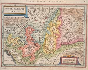
Montisferrati ducatus
Verlag: Artist: Janssonius/Mercator-Hondius H Johann ( - 1664 ) Amsterdam; issued in: unknown; Janssonius/Mercator-Hondius H Johann ( 1588 - 1664 ) Amsterdam; Johannes Janssonius (Jansson)( 1588- 1664) Amsterdam was born in Arnhem the son of Jan Janszoon the Eldera publisher and bookseller In 1612 he married Elisabeth de Hondt the daughter of Jodocus Hondius He produced his first maps in 1616 of France and Italy In 1623 Janssonius owned a bookstore in Frankfurt am Main later also in Danzig Stockholm Copenhagen Berlin Königsberg Geneva and Lyon In the 1630s he formed a partnership with his brother in law Henricus Hondius and together they published atlases as Mercator/Hondius/Janssonius Under the leadership of Janssonius the Hondius Atlas was steadi, 1588
Anbieter: Antique Sommer& Sapunaru KG, München, Deutschland
Bewertung:
Technic: Copper print; colorit: original colored; condition: Very good; size (in cm): 15 x 20 cm; Map shows Piedmont with Turin, Asti, Novara and Alessandria and a title cartouche. History: In ancient times, in northern Italy, unlike in southern Italy, there was hardly any Greek colonization. For the Roman Empire, Northern Italy was initially Gallia cisalpina. Since the Middle Ages, northern Italy has been characterized by remarkable trading cities, which, starting from the Veronese Confederation, united in the Lombardenbund against Emperor Barbarossa. At that time, some basics of business administration and banking, such as double-entry bookkeeping, were created in northern Italy. In pre-Roman centuries it was inhabited by different peoples among whom the Ligures, the ancient Veneti, who prospered through their trade in amber and breeding of horses, the Etruscans, who colonized Northern Italy from Tuscany, founded the city of Bologna and spread the use of writing; later, starting from the 5th century BC, the area was invaded by Celtic ? Gallic tribes. These people founded several cities like Turin and Milan and extended their rule from the Alps to the Adriatic Sea. Their development was halted by the Roman expansion in the Po Valley from the 3rd century BC onwards. After centuries of struggle, in 194 BC the entire area of what is now Northern Italy became a Roman province with the name of Gallia Cisalpina ("Gaul on the inner side (with respect to Rome) of the Alps"). The Roman culture and language overwhelmed the former civilization in the following years, and Northern Italy became one of the most developed and rich areas of the western half of the empire with the construction of a wide array of roads and the development of agriculture and trade. After the fall of the Western Empire, Northern Italy suffered heavily from destruction brought about by migration from Germanic peoples and from the Gothic War. In the 10th century Northern Italy was formally under the rule of the Holy Roman Empire but was in fact divided in a multiplicity of small, autonomous city-states, the medieval communes and maritime republic. The 11th century marked a significant boom in Northern Italy's economy, due to improved trading and agricultural innovations, culture flourished as well with many universities founded, among them the University of Bologna, the oldest university in Europe. In the end a balance of power was reached in 1454 with the Peace of Lodi and Northern Italy ended up divided between a small number of regional states, the most powerful were the Duchies of Savoy, Milan, Mantua, Ferrara and the Republics of Genoa and Venice, which had begun to extend its influence in the mainland from the 14th century onwards. In the 15th century Northern Italy became one of the centres of the Renaissance whose culture and works of art were highly regarded. After the French Revolution in the late 18th century Northern Italy was conquered by the French armies, many client republics were created by Napoleon and in 1805 a new Kingdom of Italy, made of all of Northern Italy but Piedmont that was annexed to France, was established with Milan as capital and Napoleon as head of state. In the congress of Vienna, the Kingdom of Sardinia was restored, and furthermore enlarged by annexing the Republic of Genoa to strengthen it as a barrier against France. The rest of Northern Italy was under Austrian rule, either direct like in the Lombardo-Venetian Kingdom or indirect like in the Duchies of Parma and Modena. Bologna and Romagna were given to the Papal State.
-
Kein Einband. Zustand: Gut. Es handelt sich hierbei um eine originale, kolorierte Kupferstichlandkarte des Gebiets zwischen Lech und Donau von J. Janssonius bei H. Hondius, um das Jahr 1640. *** Titel: Nova Alemanniae sive Sueviae superioris Tabula *** Ort: Westorientierte Karte des Gebietes zwischen Lech und Donau, mit dem Bodensee und dem Allgäu. Zeigt auch Liechtenstein. *** Kartograph: Johann Janssonius (1588 - 1664) / Henricus Hondius (1597 - 1651) *** Jahr: ca. 1640 *** Größe des Plattenbereichs: 38 x 49 cm *** Technik: Kupferstich *** Zustand (Perfekt/ Sehr gut/ Gut/ Ordentlich/ Mäßig/ Schlecht): In gutem Erhaltungszustand *** Bemerkungen: Bugfalte im unteren Bereich hinterlegt. Untere Ecken mit leichten Knickspuren. - - - International buyers welcome. If you have any questions, please don't hesitate to ask. - - - ----- Auf Wunsch stellen wir Ihnen gerne ein kostenfreies Echtheitszertifikat aus ------ If you wish, we will gladly provide a certificate of authenticity free of charge ---.
-
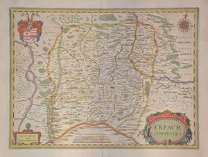
Erpach comitatus
Verlag: Artist: Janssonius/Kaerius Johann ( - 1664 ) Amsterdam; issued in: Amsterdam; Janssonius/Kaerius Johann ( 1588 - 1664 ) Amsterdam; Johannes Janssonius (Jansson)( 1588- 1664) Amsterdam was born in Arnhem the son of Jan Janszoon the Eldera publisher and bookseller In 1612 he married Elisabeth de Hondt the daughter of Jodocus Hondius He produced his first maps in 1616 of France and Italy In 1623 Janssonius owned a bookstore in Frankfurt am Main later also in Danzig Stockholm Copenhagen Berlin Königsberg Geneva and Lyon In the 1630s he formed a partnership with his brother in law Henricus Hondius and together they published atlases as Mercator/Hondius/Janssonius Under the leadership of Janssonius the Hondius Atlas was steadily enlarged Renamed, 1588
Anbieter: Antique Sommer& Sapunaru KG, München, Deutschland
Bewertung:
Technic: Copper print; colorit: original colored; condition: Very good; size (in cm): 36 x 48 cm; Map shows the district of Erbach with the Odenwald, a title cartouche, mileage scale and compass rose. Also a magnificent heraldic cartouche of Erbach and Breuberg. History: In the 12th century, Hessen was passed to Thuringia. In the War of the Thuringian Succession (1247?1264), Hessen gained independence and became a Landgraviate within the Holy Roman Empire. It shortly rose to primary importance under Landgrave Philip the Magnanimous, who was one of the leaders of German Protestantism. After Philip's death in 1567, the territory was divided among his four sons from his first marriage into four lines: Hesse-Kassel (or Hesse-Cassel), Hesse-Darmstadt, Hessen-Rheinfels, and the also previously existing Hesse-Marburg. As the latter two lines died out quite soon (1583 and 1605), Hesse-Kassel and Hesse-Darmstadt were the two core states within the Hessian lands. Several collateral lines split off during the centuries, such as in 1622, when Hessen-Homburg split off from Hesse-Darmstadt. In the late 16th century, Kassel adopted Calvinism, while Darmstadt remained Lutheran and subsequently the two lines often found themselves on different sides of a conflict, most notably in the disputes over Hessen-Marburg and in the Thirty Years' War, when Darmstadt fought on the side of the Emperor, while Kassel sided with Sweden and France. War of Hessen: The Landgrave Frederick II (1720?1785) ruled as a benevolent despot, from 1760 to 1785. He combined Enlightenment ideas with Christian values, cameralist plans for central control of the economy, and a militaristic approach toward diplomacy.He funded the depleted treasury of the poor nation by loaning 19,000 soldiers in complete military formations to Great Britainto fight in North America during the American Revolutionary War, 1776?1783. These soldiers, commonly known as Hessians, fought under the British flag. The British used the Hessians in several conflicts, including in the Irish Rebellion of 1798. For further revenue, the soldiers were loaned to other places as well. Most were conscripted, with their pay going to the Landgrave.
-
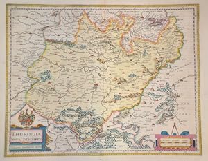
Thuringiae Nova descriptio
Verlag: Artist: Janssonius Johann ( - 1664 ) Amsterdam; issued in: Amsterdam; Janssonius Johann ( 1588 - 1664 ) Amsterdam; Johannes Janssonius (Jansson)( 1588- 1664) Amsterdam was born in Arnhem the son of Jan Janszoon the Elder a publisher and bookseller In 1612 he married Elisabeth de Hondt the daughter of Jodocus Hondius He produced his first maps in 1616 of France and Italy In 1623 Janssonius owned a bookstore in Frankfurt am Main later also in Danzig Stockholm Copenhagen Berlin Königsberg Geneva and Lyon In the 1630s he formed a partnership with his brother in law Henricus Hondius and together they published atlases as Mercator/Hondius/Janssonius Under the leadership of Janssonius the Hondius Atlas was steadily enlarged Renamed Atlas Novus it, 1588
Anbieter: Antique Sommer& Sapunaru KG, München, Deutschland
Bewertung:
Technic: Copper print; colorit: original colored; condition: Very good; size (in cm): 38 x 48 cm; Map shows the area of Erfurt in Thuringia with a title cartouche depicting a coat of arms and a mileage indicator cartouche. History: Named after the Thuringii tribe who occupied it around AD 300, Thuringia came under Frankish domination in the 6th century. The Thuringian tribe formed during the Migration Period. The Saxon Otonen and the Sangerhausen became a center of the Holy Roman Empire in the 10th century. A separate Duchy of Thuringia cannot develop in this way. Greatest power in the Thuringian war at that time was the county of Weimar. It was only the Ludowinger rights that brought parts of Thuringia under their control. In the 12th century, the process of expanding the state in Thuringia was secured. It is called the first climbed cities such as Mühlhausen. The important noble families of medieval Thuringia were next to the dominant Wettin and the Ludowingern. In 1485, with the division of Leipzig, the wet lands were sold to the Albertiner rights in the east and the Ernestiner administration in the west. With the Reformation at the beginning of the 16th century, Thuringia became the center of German politics. Martin Luther made announcements of responsibility at the University of Erfurt and in the Augustinian monastery before he went to Wittenberg and the Reformation began. In 1640, two main Ernestine lines emerged: the House of Saxony-Weimar and the House of Saxony-Gotha. Subsequently, the phase of humanism began in Thuringia, in which the University of Erfurt also had a heyday. A center of German humanism was formed around Ulrich von Hutten and the reformers. It was only around 1780 that the ruling Duchess Anna Amalia and her son Karl August left the region again. They called poets such as Johann Wolfgang von Goethe or Friedrich Schiller and their court, where they established Weimar Classicism as a German version of the classic literary movement. In 1833, the Customs and Trade Association of the Thuringian States was founded, which spurred industrial revolution in the country. As a result of industrialization, Thuringia became the cradle of social democracy. 1869 Greater August Bebel and Wilhelm Liebknecht in Eisenach the Social Democratic Workers 'Party, in 1875 merged with the General German Workers' Association in Gotha to form the SPD. The Gotha program and the Erfurt program subsequently defined the goals of social democratic politics in Germany.
-
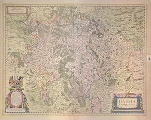
Hassia Landgraviatus.
Verlag: Artist: Janssonius/Mercator-Hondius H Johann ( - 1664 ) Amsterdam; issued in: Amsterdam; Janssonius/Mercator-Hondius H Johann ( 1588 - 1664 ) Amsterdam; Johannes Janssonius (Jansson)( 1588- 1664) Amsterdam was born in Arnhem the son of Jan Janszoon the Eldera publisher and bookseller In 1612 he married Elisabeth de Hondt the daughter of Jodocus Hondius He produced his first maps in 1616 of France and Italy In 1623 Janssonius owned a bookstore in Frankfurt am Main later also in Danzig Stockholm Copenhagen Berlin Königsberg Geneva and Lyon In the 1630s he formed a partnership with his brother in law Henricus Hondius and together they published atlases as Mercator/Hondius/Janssonius Under the leadership of Janssonius the Hondius Atlas was stea, 1588
Anbieter: Antique Sommer& Sapunaru KG, München, Deutschland
Bewertung:
Technic: Copper print; colorit: original colored; condition: Very good; size (in cm): 44 x 56 cm; Map shows the area between Alsfeld, Eisenach and Northeim, a title cartouche and the coat of arms of the Landgraviate of Hesse. History: In the 12th century, Hessen was passed to Thuringia. In the War of the Thuringian Succession (1247?1264), Hessen gained independence and became a Landgraviate within the Holy Roman Empire. It shortly rose to primary importance under Landgrave Philip the Magnanimous, who was one of the leaders of German Protestantism. After Philip's death in 1567, the territory was divided among his four sons from his first marriage into four lines: Hesse-Kassel (or Hesse-Cassel), Hesse-Darmstadt, Hessen-Rheinfels, and the also previously existing Hesse-Marburg. As the latter two lines died out quite soon (1583 and 1605), Hesse-Kassel and Hesse-Darmstadt were the two core states within the Hessian lands. Several collateral lines split off during the centuries, such as in 1622, when Hessen-Homburg split off from Hesse-Darmstadt. In the late 16th century, Kassel adopted Calvinism, while Darmstadt remained Lutheran and subsequently the two lines often found themselves on different sides of a conflict, most notably in the disputes over Hessen-Marburg and in the Thirty Years' War, when Darmstadt fought on the side of the Emperor, while Kassel sided with Sweden and France. War of Hessen: The Landgrave Frederick II (1720?1785) ruled as a benevolent despot, from 1760 to 1785. He combined Enlightenment ideas with Christian values, cameralist plans for central control of the economy, and a militaristic approach toward diplomacy.He funded the depleted treasury of the poor nation by loaning 19,000 soldiers in complete military formations to Great Britainto fight in North America during the American Revolutionary War, 1776?1783. These soldiers, commonly known as Hessians, fought under the British flag. The British used the Hessians in several conflicts, including in the Irish Rebellion of 1798. For further revenue, the soldiers were loaned to other places as well. Most were conscripted, with their pay going to the Landgrave.
-
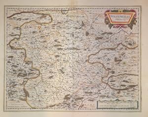
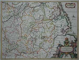
Westfalia Ducatus
Verlag: Artist: Janssonius Johann ( - 1664 ) Amsterdam; issued in: Amsterdam; Janssonius Johann ( 1588 - 1664 ) Amsterdam; Johannes Janssonius (Jansson)( 1588- 1664) Amsterdam was born in Arnhem the son of Jan Janszoon the Elder a publisher and bookseller In 1612 he married Elisabeth de Hondt the daughter of Jodocus Hondius He produced his first maps in 1616 of France and Italy In 1623 Janssonius owned a bookstore in Frankfurt am Main later also in Danzig Stockholm Copenhagen Berlin Königsberg Geneva and Lyon In the 1630s he formed a partnership with his brother in law Henricus Hondius and together they published atlases as Mercator/Hondius/Janssonius Under the leadership of Janssonius the Hondius Atlas was steadily enlarged Renamed Atlas Novus it, 1588
Anbieter: Antique Sommer& Sapunaru KG, München, Deutschland
Bewertung:
Technic: Copper print; colorit: original colored; condition: Very good; size (in cm): 38 x 49 cm; Map shows Westphalia in Hesse with title cartouche, mileage cartouche and heraldic representations in the country. History: In the 12th century, Hessen was passed to Thuringia. In the War of the Thuringian Succession (1247?1264), Hessen gained independence and became a Landgraviate within the Holy Roman Empire. It shortly rose to primary importance under Landgrave Philip the Magnanimous, who was one of the leaders of German Protestantism. After Philip's death in 1567, the territory was divided among his four sons from his first marriage into four lines: Hesse-Kassel (or Hesse-Cassel), Hesse-Darmstadt, Hessen-Rheinfels, and the also previously existing Hesse-Marburg. As the latter two lines died out quite soon (1583 and 1605), Hesse-Kassel and Hesse-Darmstadt were the two core states within the Hessian lands. Several collateral lines split off during the centuries, such as in 1622, when Hessen-Homburg split off from Hesse-Darmstadt. In the late 16th century, Kassel adopted Calvinism, while Darmstadt remained Lutheran and subsequently the two lines often found themselves on different sides of a conflict, most notably in the disputes over Hessen-Marburg and in the Thirty Years' War, when Darmstadt fought on the side of the Emperor, while Kassel sided with Sweden and France. War of Hessen: The Landgrave Frederick II (1720?1785) ruled as a benevolent despot, from 1760 to 1785. He combined Enlightenment ideas with Christian values, cameralist plans for central control of the economy, and a militaristic approach toward diplomacy.He funded the depleted treasury of the poor nation by loaning 19,000 soldiers in complete military formations to Great Britainto fight in North America during the American Revolutionary War, 1776?1783. These soldiers, commonly known as Hessians, fought under the British flag. The British used the Hessians in several conflicts, including in the Irish Rebellion of 1798. For further revenue, the soldiers were loaned to other places as well. Most were conscripted, with their pay going to the Landgrave.
-
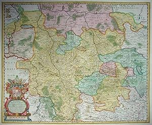
Kein Einband. Zustand: Gut. Es handelt sich hierbei um eine originale, kolorierte Kupferstich-Landkarte des Gebiets des Herzogtums Braunschweig von Johann Janssonius (1588 - 1664) aus dem Jahr 1650. *** Titel: Serenißimo Principi Ac Domino, D. Christiano Duci Brunsvicensi Et Luneburgensi Hanc accuratißiman sui Ducatus Brunsuicensis Tabulam dedicat consecratq Henricus Hondius *** Gebiet bzw. Ort: Herzogtum Braunschweig *** Kartograph: Johann Janssonius (1588 - 1664) *** Jahr: 1650 *** Größe des Plattenbereichs: 40 x 50 cm *** Technik: Kupferstich *** Zustand (Perfekt/ Sehr gut/ Gut/ Ordentlich/ Mäßig/ Schlecht): In gutem Erhaltungszustand *** Bemerkungen: - - - International buyers welcome. If you have any questions, please don't hesitate to ask. --- Auf Wunsch stellen wir Ihnen gerne ein kostenfreies Echtheitszertifikat aus --- If you wish, we will gladly provide a certificate of authenticity free of charge ---.
-
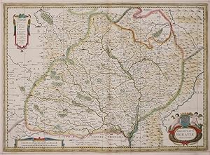
Marchionatus Moraviae Auct I. Comenio.
Verlag: Artist: Janssonius/ Pitt Moses Johann ( - 1664 ) Amsterdam; issued in: Amsterdam; Janssonius/ Pitt Moses Johann ( 1588 - 1664 ) Amsterdam; "Johannes Janssonius (Jansson)( 1588- 1664) Amsterdam was born in Arnhem the son of Jan Janszoon the Eldera publisher and bookseller In 1612 he married Elisabeth de Hondt the daughter of Jodocus Hondius He produced his first maps in 1616 of France and Italy In 1623 Janssonius owned a bookstore in Frankfurt am Main later also in Danzig Stockholm Copenhagen Berlin Königsberg Geneva and Lyon In the 1630s he formed a partnership with his brother in law Henricus Hondius and together they published atlases as Mercator/Hondius/Janssonius Under the leadership of Janssonius the Hondius Atlas was steadily enlarged, 1588
Anbieter: Antique Sommer& Sapunaru KG, München, Deutschland
Bewertung:
Technic: Copper print; colorit: original colored; condition: Some folds; size (in cm): 39 x 53,5; Map shows complete Moravia in Chzech with three decorative cartouches. History: Moravia developed on both sides of the Amber Road in prehistoric times. Around 60 BC The Celtic Boier withdrew from the area and were replaced by Germanic Marcomanni and Quadi, who moved on to the Alpine foothills around 550 AD together with the Rugians. Today's Moravia was still independent for a short time after the devastating defeat against the Hungarians and came under Bohemian sovereignty around 955. After being ruled briefly by Poland's ruler Boleslaw Chrobry from 999 to 1019, Moravia finally became Bohemian in 1031. The Principality and later Kingdom of Bohemia was ruled by the P_emyslid dynasty until it died out in the male line in 1305. Moravian history has been parallel to the history of Bohemia almost continuously since 1031. After the P_emyslids died out, the kingdom was ruled by the House of Luxembourg until 1437. The P_emyslid and Luxembourg dynasties also included the Moravian margraves, so u. a. the later King Ottokar II. P_emysl, the later King and Emperor Charles IV. and his nephew, the largely independent Margrave Jobst of Moravia. In 1469, the Hungarian King Matthias Corvinus advanced with his armed forces to Moravia to overthrow his father-in-law Georg von Podiebrad, whose daughter Katharina he married in 1461, as King of Bohemia. Matthias could never conquer the actual Bohemia, his rule only extended over the Bohemian neighboring countries Moravia, Silesia (with Breslau), Upper and Lower Lusatia. Nevertheless, he called himself King of Bohemia from 1469 and was crowned in 1471. As early as 1526, one of the first communities of property of the radical Reformation Anabaptist movement was formed around Balthasar Hubmaier in the Nikolsburg area. The impending dissolution of the Anabaptist community after the execution of Hubmaier in 1528 was prevented by Jakob Hutter, who came from Tyrol. The Anabaptists were also called the Hutterite Brothers after him. During the Catholic Reform and Recatholization, which were carried out by the Jesuits in particular, many churches were able to be consecrated Catholic again. The capital of Moravia and the seat of the margraves was the centrally located Olomouc from the rule of the Luxembourgers until 1641. After that, the larger Brno became the capital of the country. As the margraviate of Moravia, it formed its own crown land in the Austrian Empire and, from 1867, in the western half of Austria-Hungary. After Hungary left the empire and the real union Austria-Hungary was created in 1867, the remaining crown lands were officially referred to as Cisleithania or the kingdoms and countries represented in the Imperial Council.
-
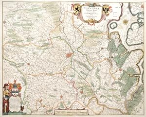
Flandriae Partes duae, quarum altera Proprietaria, altera Imperialis vulgo dicitur,
Verlag: Artist: Janssonius Johann ( - 1664 ) Amsterdam; issued in: Amsterdam; Janssonius Johann ( 1588 - 1664 ) Amsterdam; Johannes Janssonius (Jansson)( 1588- 1664) Amsterdam was born in Arnhem the son of Jan Janszoon the Elder a publisher and bookseller In 1612 he married Elisabeth de Hondt the daughter of Jodocus Hondius He produced his first maps in 1616 of France and Italy In 1623 Janssonius owned a bookstore in Frankfurt am Main later also in Danzig Stockholm Copenhagen Berlin Königsberg Geneva and Lyon In the 1630s he formed a partnership with his brother in law Henricus Hondius and together they published atlases as Mercator/Hondius/Janssonius Under the leadership of Janssonius the Hondius Atlas was steadily enlarged Renamed Atlas Novus it, 1588
Anbieter: Antique Sommer& Sapunaru KG, München, Deutschland
Bewertung:
Technic: Copper print; colorit: original colored; condition: Some folds; size (in cm): 41 x 51,5 cm; Map shows total Flandria ( Belgium) with cartouches with decorative coat of arms. The map is showing the cities of Gent, Aalst, Axel, Hust and others. History: As the province of Belgica - a name introduced by Caesar - what is now Belgium experienced many rulers. From the High Middle Ages to the early modern period, the cities of Flanders with their cloth industries represented one of the two centers of the European economy. Politically, the individual territories came under the House of Burgundy, which was inherited by the Habsburgs in 1477. In 1579 the Catholic Union of Arras and the Calvinist-Protestant Union of Utrecht were formed. The provinces of the Union of Utrecht broke away from Spain in 1581 and founded the Republic of the Seven United Provinces, whose independence was recognized in the Peace of Westphalia of 1648 after the end of the Eighty Years War. The provinces of the Union of Arras, Flanders and Brabant were administered as the Spanish Netherlands by a Spanish governor. After the extinction of the Spanish Habsburgs (1700) and the resulting War of the Spanish Succession, the Austrian Netherlands came under the rule of the Austrian Habsburgs in 1714. As a result of the absolutist-centralistic efforts of the Austrian ruler Joseph II, the Brabant Revolution came in 1789 and the short-lived United Belgian States. Revolutionary France annexed the Austrian Netherlands between 1792 and 1794, followed by incorporation into the French Republic in 1795. At the Congress of Vienna (1815) the provinces were awarded to the Netherlands. After the Belgian Revolution, the country gained independence in 1830.
-
Mecklenburg Ducatus
Verlag: Artist: Janssonius Johann ( - 1664 ) Amsterdam; issued in: Amsterdam; Janssonius Johann ( 1588 - 1664 ) Amsterdam; Johannes Janssonius (Jansson)( 1588- 1664) Amsterdam was born in Arnhem the son of Jan Janszoon the Elder a publisher and bookseller In 1612 he married Elisabeth de Hondt the daughter of Jodocus Hondius He produced his first maps in 1616 of France and Italy In 1623 Janssonius owned a bookstore in Frankfurt am Main later also in Danzig Stockholm Copenhagen Berlin Königsberg Geneva and Lyon In the 1630s he formed a partnership with his brother in law Henricus Hondius and together they published atlases as Mercator/Hondius/Janssonius Under the leadership of Janssonius the Hondius Atlas was steadily enlarged Renamed Atlas Novus it, 1588
Anbieter: Antique Sommer& Sapunaru KG, München, Deutschland
Bewertung:
Technic: Copper print; colorit: colored; condition: Very good; size (in cm): 37 x 48 cm; Map of Mecklenburg with three splendid cartouches and the coat of arms Hertzogtum Mecklenburg-Güstrow, a compass rose and two ship's tables.
-
Kein Einband. Zustand: Gut bis sehr gut. Es handelt sich hierbei um eine originale Kupferstich-Landkarte des Westfälischen Kreises von Johann Janssonius (1588 - 1664) aus dem Jahr 1664. *** Titel: Circulus Westphalicus, sive Germaniae Inferioris *** Gebiet bzw. Ort: Westfälischer Kreis mit den Gebieten Nordsee, Weserlauf, Rheinlauf und Bonn / Münden *** Kartograph: Johann Janssonius (1588 - 1664) *** Jahr: um 1640 *** Größe des Plattenbereichs: 41 x 54 cm *** Technik: Kupferstich *** Zustand (Perfekt/ Sehr gut/ Gut/ Ordentlich/ Mäßig/ Schlecht): In sehr gutem Erhaltungszustand. Mittelfalte hinterlegt. *** Bemerkungen: Eine sehr dekorativ kolorierte Karte des Westfälischen Kreises mit den Gebieten Nordsee, Weserlauf, Rheinlauf und Bonn / Münden. Die Grenzen der westorientierten Karte liegen auf einer Linie Nijmegen - Venlo im Westen, Bonn im Süden und der Weser im Osten. Hamburg wird auf einer kleinen Insetkarte in der Kartusche dargestellt. - - - International buyers welcome. If you have any questions, please don't hesitate to ask. --- Auf Wunsch stellen wir Ihnen gerne ein kostenfreies Echtheitszertifikat aus --- If you wish, we will gladly provide a certificate of authenticity free of charge ---.
-
Wirtenberg Ducatus.
Verlag: Artist: Janssonius/Mercator-Hondius H Johann ( - 1664 ) Amsterdam; issued in: Amsterdam; Janssonius/Mercator-Hondius H Johann ( 1588 - 1664 ) Amsterdam; Johannes Janssonius (Jansson)( 1588- 1664) Amsterdam was born in Arnhem the son of Jan Janszoon the Eldera publisher and bookseller In 1612 he married Elisabeth de Hondt the daughter of Jodocus Hondius He produced his first maps in 1616 of France and Italy In 1623 Janssonius owned a bookstore in Frankfurt am Main later also in Danzig Stockholm Copenhagen Berlin Königsberg Geneva and Lyon In the 1630s he formed a partnership with his brother in law Henricus Hondius and together they published atlases as Mercator/Hondius/Janssonius Under the leadership of Janssonius the Hondius Atlas was stea, 1588
Anbieter: Antique Sommer& Sapunaru KG, München, Deutschland
Bewertung:
Technic: Copper print; colorit: original colored; condition: Some restoration at centerfold, fold across pressed and mounted; size (in cm): 37 x 44,5 cm; Map shows the whole of Württemberg with a title cartouche and the coat of arms of the Duchy of Württemberg. History: Baden-Wuertemberg is a state in southwest Germany, east of the Rhine, which forms the border with France. It is is formed from the historical territories of Baden, Prussian Hohenzollern, and Württemberg, and also parts of Swabia. Baden Würtemberg was only founded in 1952 by the merger of the states of Württemberg-Baden, Baden and Württemberg-Hohenzollern. Today the most populous city of Baden-Württemberg is the state capital Stuttgart, followed by Karlsruhe and Mannheim. Other major cities are Freiburg im Breisgau, Heidelberg, Ulm, Heilbronn, Pforzheim and Reutlingen. The early modern period was marked by the Reformation and the expansion efforts of the emerging states of Austria, Prussia, France and Sweden. Conflicts such as the Peasant War, the Thirty Years' War and the Palatinate War of Succession resulted from these. One of the focal points of the fighting, with corresponding consequences for the population and the economy, was in what is today Baden-Württemberg, which remained extremely fragmented territorially. At the beginning of the 19th century, around 300 states still had territorial rights in what is now Baden-Württemberg, but their number was reduced to four after the dissolution of the Old Empire. The Kingdom of Württemberg and the Grand Duchy of Baden were among the winners of the coalition wars. The two principalities of Hohenzollern-Sigmaringen and Hohenzollern-Hechingen survived mediatization due to their special relationship with Napoléon. In 1849, the Baden Revolution was put down by Prussian intervention forces, the Baden army was dissolved and rebuilt under Prussian leadership. In 1850 the two Hohenzollern states became the Prussian province of Hohenzollernsche Lande. With the new formation of the tribal duchies, the southern areas of what is now the state of Baden-Württemberg belonged to the Duchy of Swabia until the end of the High Middle Ages, the northern areas were located with the Duchy of Franconia.
-
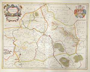
Saxonia superior
Verlag: Artist: Janssonius Johann ( - 1664 ) Amsterdam; issued in: Amsterdam; Janssonius Johann ( 1588 - 1664 ) Amsterdam; Johannes Janssonius (Jansson)( 1588- 1664) Amsterdam was born in Arnhem the son of Jan Janszoon the Elder a publisher and bookseller In 1612 he married Elisabeth de Hondt the daughter of Jodocus Hondius He produced his first maps in 1616 of France and Italy In 1623 Janssonius owned a bookstore in Frankfurt am Main later also in Danzig Stockholm Copenhagen Berlin Königsberg Geneva and Lyon In the 1630s he formed a partnership with his brother in law Henricus Hondius and together they published atlases as Mercator/Hondius/Janssonius Under the leadership of Janssonius the Hondius Atlas was steadily enlarged Renamed Atlas Novus it, 1588
Anbieter: Antique Sommer& Sapunaru KG, München, Deutschland
Bewertung:
Technic: Copper print; colorit: original colored; condition: Restoration at centerfold; size (in cm): 38,5 x 49,5; Map shows Saxony-Anhalt with the city of Wittenberg and Halle in Saxony. Furthermore, a title cartouche and the coat of arms of the Wettins, rulers in Saxony. History: The area of today's state of Saxony-Anhalt was one of the cultural focal points in the German-speaking area in the early Middle Ages. Today's state capital Magdeburg was at that time one of the political centers in the Holy Roman Empire of the German Nation. The well-preserved architectural monuments from the Romanesque and Gothic periods, such as the cathedrals in Magdeburg and Halberstadt, the old town of Quedlinburg and many castles and churches, testify to the earlier importance of the entire region. The state was created in July 1947 through the unification of the Free State of Anhalt with the Prussian provinces of Magdeburg and Halle-Merseburg, which the Free State of Prussia had created in April 1944 by dividing its province of Saxony.
-
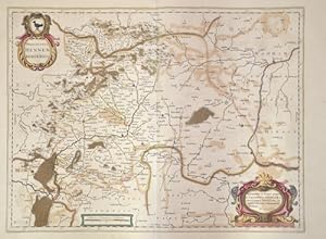
Principatus Hennenberg
Verlag: Artist: Janssonius/Mercator-Hondius H Johann ( - 1664 ) Amsterdam; issued in: Amsterdam; Janssonius/Mercator-Hondius H Johann ( 1588 - 1664 ) Amsterdam; Johannes Janssonius (Jansson)( 1588- 1664) Amsterdam was born in Arnhem the son of Jan Janszoon the Eldera publisher and bookseller In 1612 he married Elisabeth de Hondt the daughter of Jodocus Hondius He produced his first maps in 1616 of France and Italy In 1623 Janssonius owned a bookstore in Frankfurt am Main later also in Danzig Stockholm Copenhagen Berlin Königsberg Geneva and Lyon In the 1630s he formed a partnership with his brother in law Henricus Hondius and together they published atlases as Mercator/Hondius/Janssonius Under the leadership of Janssonius the Hondius Atlas was stea, 1588
Anbieter: Antique Sommer& Sapunaru KG, München, Deutschland
Bewertung:
Technic: Copper print; colorit: original colored; condition: Very good; size (in cm): 37 x 49 cm; Map of the county of Heneberg with two cartouches and a coat of arms. History: The Franconia fell to today's Franconia region with their victories over the Alemanni and Thuringians in their core areas in the 6th century. After the Franconian divisions, the Francia orientialis from the areas of the dioceses of Mainz, Worms, Würzburg and Speyer was added, and later the diocese of Bamberg was added. In the 7th century, the Slavs began to populate the northeastern parts of the region from the east, since the areas of today's Upper Franconia were sparsely populated (Bavaria Slavica). Charlemagne developed the areas around the Main into a royal province. From the middle of the 9th century, the Duchy of the Tribes, one of the five Duchies of the Eastern Franconian Empire, was established. From the 12th century, the Nuremberg Castle was the seat of the castle county of Nuremberg. From around 1190, the burgrave was ruled by the Zollern, the Frankish line of the later Hohenzollern, who represented the German emperor in the 19th and 20th centuries. Franconia already played an important role for the kingship in the time of Rudolf von Habsburg, the Itineraries of the following kings attested to the favoritism of the Rhine-Main region. In 1376 the Swabian Association of Cities was founded, which later also included several Franconian imperial cities. In July 1500, during the reign of Emperor Maximilian I, the empire was divided into imperial circles in the course of the imperial reform movement, which led to the creation of the Franconian imperial circle in 1512. From today's perspective, the Franconian Imperial Circle is sometimes considered to be an important basis for the development of a Franconian sense of community that still exists today. Franconia played an important role in the expansion of Martin Luther's Reformation. From 1552, the margrave Albrecht Alcibiades tried to break the supremacy of the mighty imperial city of Nuremberg and to secularize the possessions of the princes in order to create a duchy that he ruled. Large areas of Franconia were finally devastated in the fighting until King Ferdinand I, with several dukes and princes, decided to subjugate Albrecht. In 1608, Protestant sovereigns united in the Reich to form the so-called Union. The Catholic side reacted in 1609 with a counter-alliance, the league. The contrasts between the two camps eventually led to the Thirty Years' War, which became the greatest burden of cohesion within the Franconian Empire. From 1803 the later Kingdom of Bavaria received large parts of Franconia with the main deputation of the Imperial Deputation under the pressure of Napoleon Bonaparte through secularization and mediatization. Through the Rhine Confederation, Bavaria, Württemberg, Baden and other areas became more closely linked to France, which disintegrated the Holy Roman Empire and the Franconian Empire in 1806.
-
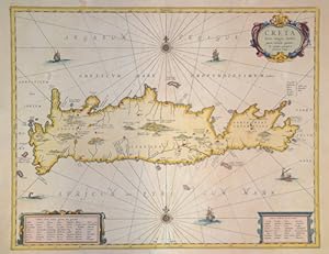
Creta Iovis magni, medio jacet insula ponto.
Verlag: Artist: Janssonius Johann ( - 1664 ) Amsterdam; issued in: Amsterdam; Janssonius Johann ( 1588 - 1664 ) Amsterdam; Johannes Janssonius (Jansson)( 1588- 1664) Amsterdam was born in Arnhem the son of Jan Janszoon the Elder a publisher and bookseller In 1612 he married Elisabeth de Hondt the daughter of Jodocus Hondius He produced his first maps in 1616 of France and Italy In 1623 Janssonius owned a bookstore in Frankfurt am Main later also in Danzig Stockholm Copenhagen Berlin Königsberg Geneva and Lyon In the 1630s he formed a partnership with his brother in law Henricus Hondius and together they published atlases as Mercator/Hondius/Janssonius Under the leadership of Janssonius the Hondius Atlas was steadily enlarged Renamed Atlas Novus it, 1588
Anbieter: Antique Sommer& Sapunaru KG, München, Deutschland
Bewertung:
Technic: Copper print; colorit: original colored; condition: Mounted, missing part on lower center replaced.; size (in cm): 37,5 x 48 cm; Map shows the Greek island of Crete with title cartouche and two index cartouches. Furthermore, sailing ship portraits, a sea monster and two wind roses. Geographer Abraham OrteliusHistory: The island of Creta is first described in texts from the Syrian city of Mari in the 18th century BC. BC called Kaptara, which are later repeated in Neoassyrian records and in the Bible (Caphtor). It was also known as Keftiu in ancient Egypt, strongly suggesting that a shape similar to both was the Minoan name for the island.
-
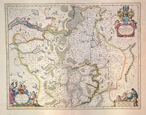
Marchia Media vulgo Mittel Marck in March Brandenb.
Verlag: Artist: Janssonius Johann ( - 1664 ) Amsterdam; issued in: Amsterdam; Janssonius Johann ( 1588 - 1664 ) Amsterdam; Johannes Janssonius (Jansson)( 1588- 1664) Amsterdam was born in Arnhem the son of Jan Janszoon the Elder a publisher and bookseller In 1612 he married Elisabeth de Hondt the daughter of Jodocus Hondius He produced his first maps in 1616 of France and Italy In 1623 Janssonius owned a bookstore in Frankfurt am Main later also in Danzig Stockholm Copenhagen Berlin Königsberg Geneva and Lyon In the 1630s he formed a partnership with his brother in law Henricus Hondius and together they published atlases as Mercator/Hondius/Janssonius Under the leadership of Janssonius the Hondius Atlas was steadily enlarged Renamed Atlas Novus it, 1588
Anbieter: Antique Sommer& Sapunaru KG, München, Deutschland
Bewertung:
Technic: Copper print; colorit: original colored; condition: Very good; size (in cm): 41 x 51 cm; Magnificent map showing Mittel Marck, the surroundings of Berlin, Stettin, and much more. Furthermore three cartouches, a title cartouche, a mileage indicator cartouche and a coat of arms cartouche. History: The province of Pomerania, located in the north German lowlands, was the Prussian province formed from the Duchy of Pomerania after the Vienna Congress in 1815. It consisted of western Pomerania and Western Pomerania. Pomerania's capital was Szczecin. Through the Peace of Westphalia in 1648, Hinterpommern came to Brandenburg and Vorpommern became Swedish-Pommern. The Brandenburg Elector Friedrich Wilhelm I succeeded in conquering all of Swedish Pomerania in 1678, but he had to forego the majority of the conquered areas under pressure from France in the Peace of Saint-Germain (1679). After the end of the Great Northern War (1700-1721), the part of Western Pomerania south of the Peene came to Prussia (Old Western Pomerania). During the territorial reorganization of Europe in 1815, the last part of Western Pomerania, which remained Swedish, became Prussian with the island of Rügen (New Western Pomerania). At the same time, Pomerania received the districts of Dramburg and Schivelbein as well as the northern parts of the Arnswalde district with the town of Nörenberg from the Neumark, which otherwise remained with the province of Brandenburg.
-
Territorium Abbatiae Herelsfeldensisis
Verlag: Artist: Janssonius Johann ( - 1664 ) Amsterdam; issued in: Amsterdam; Janssonius Johann ( 1588 - 1664 ) Amsterdam; Johannes Janssonius (Jansson)( 1588- 1664) Amsterdam was born in Arnhem the son of Jan Janszoon the Elder a publisher and bookseller In 1612 he married Elisabeth de Hondt the daughter of Jodocus Hondius He produced his first maps in 1616 of France and Italy In 1623 Janssonius owned a bookstore in Frankfurt am Main later also in Danzig Stockholm Copenhagen Berlin Königsberg Geneva and Lyon In the 1630s he formed a partnership with his brother in law Henricus Hondius and together they published atlases as Mercator/Hondius/Janssonius Under the leadership of Janssonius the Hondius Atlas was steadily enlarged Renamed Atlas Novus it, 1588
Anbieter: Antique Sommer& Sapunaru KG, München, Deutschland
Bewertung:
Technic: Copper print; colorit: original colored; condition: Very good; size (in cm): 39 x 50 cm; Partial map of Hesse with the town of Bad Hersfeld (Hirschfelt) and surroundings. Furthermore, a title cartouche with putti and the coat of arms of Bad Hersfeld. History: In the 12th century, Hessen was passed to Thuringia. In the War of the Thuringian Succession (1247?1264), Hessen gained independence and became a Landgraviate within the Holy Roman Empire. It shortly rose to primary importance under Landgrave Philip the Magnanimous, who was one of the leaders of German Protestantism. After Philip's death in 1567, the territory was divided among his four sons from his first marriage into four lines: Hesse-Kassel (or Hesse-Cassel), Hesse-Darmstadt, Hessen-Rheinfels, and the also previously existing Hesse-Marburg. As the latter two lines died out quite soon (1583 and 1605), Hesse-Kassel and Hesse-Darmstadt were the two core states within the Hessian lands. Several collateral lines split off during the centuries, such as in 1622, when Hessen-Homburg split off from Hesse-Darmstadt. In the late 16th century, Kassel adopted Calvinism, while Darmstadt remained Lutheran and subsequently the two lines often found themselves on different sides of a conflict, most notably in the disputes over Hessen-Marburg and in the Thirty Years' War, when Darmstadt fought on the side of the Emperor, while Kassel sided with Sweden and France. War of Hessen: The Landgrave Frederick II (1720?1785) ruled as a benevolent despot, from 1760 to 1785. He combined Enlightenment ideas with Christian values, cameralist plans for central control of the economy, and a militaristic approach toward diplomacy.He funded the depleted treasury of the poor nation by loaning 19,000 soldiers in complete military formations to Great Britainto fight in North America during the American Revolutionary War, 1776?1783. These soldiers, commonly known as Hessians, fought under the British flag. The British used the Hessians in several conflicts, including in the Irish Rebellion of 1798. For further revenue, the soldiers were loaned to other places as well. Most were conscripted, with their pay going to the Landgrave.
-
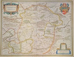
Nassovia comitatus
Verlag: Artist: Janssonius/Mercator-Hondius H Johann ( - 1664 ) Amsterdam; issued in: unknown; Janssonius/Mercator-Hondius H Johann ( 1588 - 1664 ) Amsterdam; Johannes Janssonius (Jansson)( 1588- 1664) Amsterdam was born in Arnhem the son of Jan Janszoon the Eldera publisher and bookseller In 1612 he married Elisabeth de Hondt the daughter of Jodocus Hondius He produced his first maps in 1616 of France and Italy In 1623 Janssonius owned a bookstore in Frankfurt am Main later also in Danzig Stockholm Copenhagen Berlin Königsberg Geneva and Lyon In the 1630s he formed a partnership with his brother in law Henricus Hondius and together they published atlases as Mercator/Hondius/Janssonius Under the leadership of Janssonius the Hondius Atlas was steadi, 1588
Anbieter: Antique Sommer& Sapunaru KG, München, Deutschland
Bewertung:
Technic: Copper print; colorit: original colored; condition: Some restoration at centerfold; size (in cm): 38 x 49 cm; Map shows Nordrhein-Westfalen with Siegen Rheinlandpfalz with Koblenz and Hessen with Wiesbaden.