
Gesamtpreis (1 Artikel Artikel):
Versandziel:

JODOCUS HONDIUS II (27 Ergebnisse)
Direkt zu den wichtigsten Suchergebnissen
Produktart
- Alle Produktarten
- Bücher (19)
- Magazine & Zeitschriften
- Comics
- Noten
- Kunst, Grafik & Poster
- Fotografien
- Karten (8)
-
Manuskripte &
Papierantiquitäten
Zustand
- Alle
- Neu
- Antiquarisch/Gebraucht
Einband
- alle Einbände
- Hardcover
- Softcover
Weitere Eigenschaften
- Erstausgabe
- Signiert
- Schutzumschlag
- Angebotsfoto
- Kein Print-on-Demand
Land des Verkäufers
Verkäuferbewertung
-
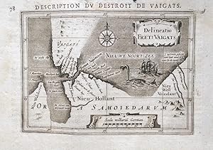
No Binding. Zustand: Good. 1st Edition thus. DH302112. Original and scarce miniature map of the straits between northern Russia and Vaygach Island. Printed in 1618 in 'La Geographie Racourcie' in Paris. Size: 13.8cm x 9.7cm. Original copper engraving. Map features a decorative title cartouche with text in Latin. French title above the map with French text to the reverse. Frayed to the top edge of the page to within 2mm of the text. Age staining to the margins which only very slightly affects the map. In good condition overall. These miniature maps by Bertius and engraved by Hondius have been referred to as 'undoubtedly the finest set of miniature maps ever printed'.
-
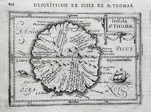
No Binding. Zustand: Very Good Plus. 1st Edition thus. DH302104. Original and scarce miniature map of the island of Sao Tome. Printed in 1618 in 'La Geographie Racourcie' in Paris. Size: 13.8cm x 9.7cm. Original copper engraving. Map features a decorative title cartouche with text in Latin. French title above the map with French text to the reverse. Age staining to the margins which only very slightly affects the map. In very good plus, clean condition overall. These miniature maps by Bertius and engraved by Hondius have been referred to as 'undoubtedly the finest set of miniature maps ever printed'.
-
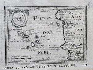
No Binding. Zustand: Very Good Plus. 1st Edition thus. DH302203. Original and scarce miniature map of the Cape Verde Islands off the coast of continental Africa.Printed in 1618 in 'La Geographie Racourcie' in Paris. Size: 13.8cm x 9.7cm. Original copper engraving. Map features a decorative title cartouche with text in Latin and a scale in miles. French title above the map with French text to the reverse. Printed upside down. Age staining to the margins which only very slightly affects the map. In very good plus, clean condition overall. These miniature maps by Bertius and engraved by Hondius have been referred to as 'undoubtedly the finest set of miniature maps ever printed'.
-
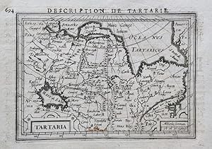
No Binding. Zustand: Very Good Plus. 1st Edition thus. DH302202. Original and scarce miniature map of the region of Tartary. Shows the Strait of Anian, the Mare de Sala or Caspian Sea and the great Wall of China. Printed in 1618 in 'La Geographie Racourcie' in Paris. Size: 13.8cm x 9.7cm. Original copper engraving. Map features a decorative title with text in Latin and a scale in miles. French title above the map with French text to the reverse. Age staining to the margins which only very slightly affects the map. Minor ink annotation to the base of the map. In very good, clean condition overall. These miniature maps by Bertius and engraved by Hondius have been referred to as 'undoubtedly the finest set of miniature maps ever printed'.
-
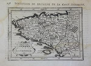
No Binding. Zustand: Very Good Plus. 1st Edition thus. DH302104. Original and scarce miniature map of the Brittany region of France. Printed in 1618 in 'La Geographie Racourcie' in Paris. Size: 13.8cm x 9.7cm. Original copper engraving. Map features a decorative title cartouche with text in Latin. French title above the map with French text to the reverse. Includes a scale in miles. Age staining to the margins which only very slightly affects the map. In very good, clean condition overall. These miniature maps by Bertius and engraved by Hondius have been referred to as 'undoubtedly the finest set of miniature maps ever printed'.
-
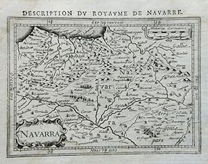
No Binding. Zustand: Very Good Plus. 1st Edition thus. Original and scarce miniature map of the Kingdom of Navarra in northern Spain. Printed in 1618 in 'La Geographie Racourcie' in Paris. Size: 13.8cm x 9.7cm. Original copper engraving. Map features a decorative title cartouche with text in Latin. French title above the map with French text to the reverse. Minor age staining to the margins which only very slightly affects the map. In very good, clean condition overall with good margins. These miniature maps by Bertius and engraved by Hondius have been referred to as 'undoubtedly the finest set of miniature maps ever printed'.
-
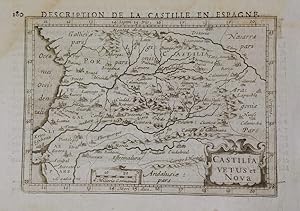
No Binding. Zustand: Very Good Plus. 1st Edition thus. DH302103. Original and scarce miniature map of the Castilian region of Spain. Printed in 1618 in 'La Geographie Racourcie' in Paris. Size: 13.8cm x 9.7cm. Original copper engraving. Map features a decorative title cartouche with text in Latin. French title above the map with French text to the reverse. Includes a scale in miles. Age staining to the top and left hand margins which only very slightly affects the map. In very good plus, clean condition overall. These miniature maps by Bertius and engraved by Hondius have been referred to as 'undoubtedly the finest set of miniature maps ever printed'.
-
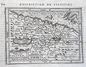
No Binding. Zustand: Very Good Plus. 1st Edition thus. DH302207. Original and scarce miniature map of the region of Palestine. Printed in 1618 in 'La Geographie Racourcie' in Paris. Size: 13.8cm x 9.7cm. Original copper engraving. Map features a decorative title cartouche with text in Latin. French title above the map with French text to the reverse. Minor age staining to the margins which only very slightly affects the map. In very good plus, clean condition overall with good margins. These miniature maps by Bertius and engraved by Hondius have been referred to as 'undoubtedly the finest set of miniature maps ever printed'.
-
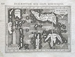
No Binding. Zustand: Very Good Plus. 1st Edition thus. DH302208. Original and scarce miniature map of the Indonesian Maluku or Moluccas Islands. Printed in 1618 in 'La Geographie Racourcie' in Paris. Size: 13.8cm x 9.7cm. Original copper engraving. Map features a decorative title cartouche with text in Latin. French title above the map with French text to the reverse. Minor age staining to the margins which only very slightly affects the map. In very good plus, clean condition overall with good margins. These miniature maps by Bertius and engraved by Hondius have been referred to as 'undoubtedly the finest set of miniature maps ever printed'.
-
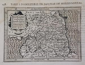
NORTHUMBRIA, CUMBERLANDIA AND DUNELMENSIS: TABLE I D'ANGLETERRE EN LAQUELLE EST NORTHUMBRIE: MAP
Verlag: Paris, France, 1618
No Binding. Zustand: Very Good Plus. 1st Edition thus. DH302101. Original and scarce miniature map of the north of England. Printed in 1618 in 'La Geographie Racourcie' in Paris. Size: 13.8cm x 9.7cm. Original copper engraving. Map features a decorative title cartouche with Latin title. French title above the map with French text to the reverse. Includes a scale in miles. Minor age staining to the top left corner and top edge which only very slightly affects the map. In very good plus, clean condition overall. These miniature maps by Bertius and engraved by Hondius have been referred to as 'undoubtedly the finest set of miniature maps ever printed'.
-
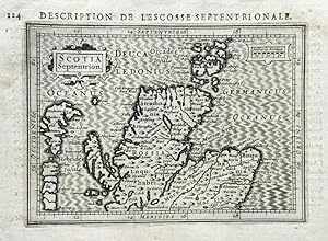
No Binding. Zustand: Very Good Plus. 1st Edition thus. DH302206. Original and scarce miniature map of Scotland. Printed in 1618 in 'La Geographie Racourcie' in Paris. Size: 13.8cm x 9.7cm. Original copper engraving. Map features a decorative title cartouche with text in Latin. French title above the map with French text to the reverse. Very minor age staining to the margins which only very slightly affects the map. In very good plus, clean condition overall with good margins. These miniature maps by Bertius and engraved by Hondius have been referred to as 'undoubtedly the finest set of miniature maps ever printed'.
-
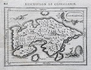
No Binding. Zustand: Very Good Plus. 1st Edition thus. DH302205. Original and scarce miniature map of the island of Kefalonia in the Ionian sea. Printed in 1618 in 'La Geographie Racourcie' in Paris. Size: 13.8cm x 9.7cm. Original copper engraving. Map features a decorative title cartouche with text in Latin. French title above the map with French text to the reverse. Age staining to the margins which only very slightly affects the map. In very good plus, clean condition overall with good margins. These miniature maps by Bertius and engraved by Hondius have been referred to as 'undoubtedly the finest set of miniature maps ever printed'.
-
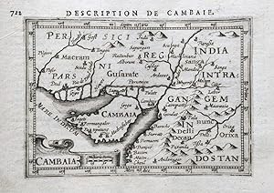
No Binding. Zustand: Very Good Plus. 1st Edition thus. DH302104. Original and scarce miniature map of the the area around Khambat, Gujarat and India. Printed in 1618 in 'La Geographie Racourcie' in Paris. Size: 13.8cm x 9.7cm. Original copper engraving. Map features a decorative title cartouche with text in Latin. French title above the map with French text to the reverse. Age staining to the margins which only very slightly affects the map. In very good plus, clean condition overall with good margins. These miniature maps by Bertius and engraved by Hondius have been referred to as 'undoubtedly the finest set of miniature maps ever printed'.
-
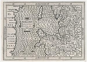
Westmorlad: Lancastria etc.
Erscheinungsdatum: 1639
Anbieter: Altea Antique Maps, London, Vereinigtes Königreich
Verbandsmitglied: ABA ILAB PBFA
Bewertung:

Karte
Amsterdam: Willem Blaeu, 1639. 100 x 135mm. Trimmed close to printed border on three sides. A reduced version of Mercator's map of north west England and northern Wales, issued as one of five regions of England and Wales, with parts of Cumberland, Westmorland, Lancashire, Cheshire and Shropshire. It was engraved for a new edition of the Bertius 'Tabularum geographicarum contractarum' published by Hondius in 1616, which King describes as 'the finest set of miniature maps ever printed'. This example was issued in a Dutch pocket edition of 'Camden's Britannia'. Hondius (c.1594-1629) was the son of the Jodocus Hondius who engraved the John Speed county maps. He left the family business to set up on his own c.1621; after his early death many of his copper plates were sold to the rival Blaeu firm. KING: Miniature Antique Maps, p. 96-99.
-
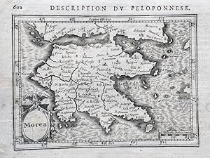
No Binding. Zustand: Very Good Plus. 1st Edition thus. Original and scarce miniature map of the Peloponnese peninsula which was known as Morea in the Middle Ages. Printed in 1618 in 'La Geographie Racourcie' in Paris. Size: 13.8cm x 9.7cm. Original copper engraving. Map features a decorative title cartouche with text in Latin. French title above the map with French text to the reverse. Very minor age staining to the margins which only very slightly affects the map. In very good plus, clean condition overall with good margins. These miniature maps by Bertius and engraved by Hondius have been referred to as 'undoubtedly the finest set of miniature maps ever printed'.
-
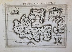
No Binding. Zustand: Very Good Plus. 1st Edition thus. 1st edition thus. DH302210. Original and scarce miniature map of the island of Elba in the Tuscan Archipelago. Printed in 1618 in 'La Geographie Racourcie' in Paris. Size: 13.8cm x 9.7cm. Original copper engraving. Map features a decorative title cartouche with text in Latin. French title above the map with French text to the reverse. Minor age staining to the margins which only very slightly affects the map. In very good plus, clean condition overall with good margins. These miniature maps by Bertius and engraved by Hondius have been referred to as 'undoubtedly the finest set of miniature maps ever printed'.
-
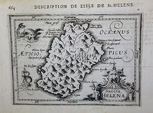
No Binding. Zustand: Very Good Plus. 1st Edition thus. DH302209. Original and scarce miniature map of the island of Saint Helena in the South Atlantic Ocean. Printed in 1618 in 'La Geographie Racourcie' in Paris. Size: 13.8cm x 9.7cm. Original copper engraving. Map features a decorative title cartouche with text in Latin. French title above the map with French text to the reverse. Minor age staining to the margins which only very slightly affects the map. In very good plus, clean condition overall with good margins. These miniature maps by Bertius and engraved by Hondius have been referred to as 'undoubtedly the finest set of miniature maps ever printed'.
-
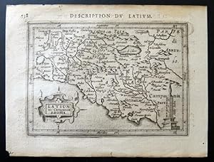
Latium sive Campania di Roma.
Erscheinungsdatum: 1620
Anbieter: BOTTEGHINA D'ARTE GALLERIA KÚPROS, Rosignano Solvay, LI, Italien
Bewertung:
Buch
No legatura. Zustand: ottimo. Tratta dal "Tabularum Geographicarum contractarum libri septem" di Petrus Bertius, edizione francese del 1620 circa (l edizione latina č 1612 e 1616). Incisione in rame all acquaforte, b/n, cm 10 x 13,7 (alla lastra) piů margini. L'opera del Bertius conteneva oltre 200 carte di derivazione dai grandi atlanti del Mercatore e dell Hondius e furono per lo piů incise da Barent Langenes. Ben impressa e in margini, molto buono lo stato di conservazione. .
-
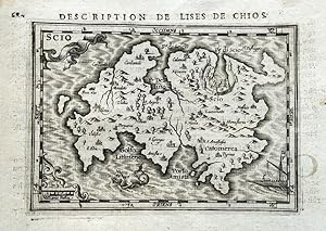
No Binding. Zustand: Very Good Plus. 1st Edition thus. Original and scarce miniature map of the island of Chios in the northern Aegean sea. Printed in 1618 in 'La Geographie Racourcie' in Paris. Size: 13.8cm x 9.7cm. Original copper engraving. Map features a decorative title cartouche with text in Latin. French title above the map with French text to the reverse. Very minor age staining to the margins which only very slightly affects the map. In very good plus, clean condition overall with good margins. These miniature maps by Bertius and engraved by Hondius have been referred to as 'undoubtedly the finest set of miniature maps ever printed'.
-
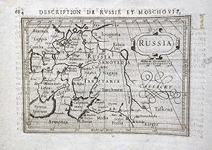
No Binding. Zustand: Very Good Plus. 1st Edition thus. DH302113. Original and scarce miniature map of Russia. Printed in 1618 in 'La Geographie Racourcie' in Paris. Size: 13.8cm x 9.7cm. Original copper engraving. Map features a decorative title cartouche with text in Latin. French title above the map with French text to the reverse. Age staining to the margins which only very slightly affects the map. In very good plus, clean condition overall with good margins. These miniature maps by Bertius and engraved by Hondius have been referred to as 'undoubtedly the finest set of miniature maps ever printed'.
-
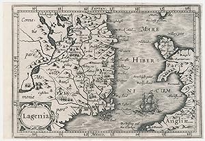
Lagenia.
Erscheinungsdatum: 1639
Anbieter: Altea Antique Maps, London, Vereinigtes Königreich
Verbandsmitglied: ABA ILAB PBFA
Bewertung:
Karte
Amsterdam: Willem Blaeu, 1639. 100 x 135mm. Trimmed close to printed border on three sides. A map of Leinster, engraved for a new edition of the Bertius 'Tabularum geographicarum contractarum' published by Hondius in 1616, which King describes as 'the finest set of miniature maps ever printed'. This example was issued in a Dutch pocket edition of 'Camden's Britannia'. Hondius (c.1594-1629) was the son of the Jodocus Hondius who engraved the John Speed county maps. He left the family business to set up on his own c.1621; after his early death many of his copper plates were sold to the rival Blaeu firm. KING: Miniature Antique Maps, p. 96-99.
-

Tartaria.
Erscheinungsdatum: 1616
Anbieter: Altea Antique Maps, London, Vereinigtes Königreich
Verbandsmitglied: ABA ILAB PBFA
Bewertung:
Karte
Amsterdam: Jodocus Hondius, 1616. Coloured. 100 x 135mm. Miniature map of Tartary, with 'the Strait of Anian' and the Great Wall of China marked, engraved by Jodocus Hondius for his edition of Petrus Bertius's 'Tabularum Geographicarum Contractarum'. Unlike the earlier plate, this version has longitude and latitude lines. KOEMAN: Lan 11a, 'With the new plates, the work was certainly improved.
-
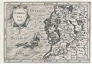
Connatia 1616.
Erscheinungsdatum: 1639
Anbieter: Altea Antique Maps, London, Vereinigtes Königreich
Verbandsmitglied: ABA ILAB PBFA
Bewertung:
Karte
Amsterdam: Willem Blaeu, 1639. 100 x 135mm. Trimmed close to printed border on three sides. A map of Connaught, engraved for a new edition of the Bertius 'Tabularum geographicarum contractarum' published by Hondius in 1616, which King describes as 'the finest set of miniature maps ever printed'. This example was issued in a Dutch pocket edition of 'Camden's Britannia'. Hondius (c.1594-1629) was the son of the Jodocus Hondius who engraved the John Speed county maps. He left the family business to set up on his own c.1621; after his early death many of his copper plates were sold to the rival Blaeu firm. KING: Miniature Antique Maps, p. 96-99.
-
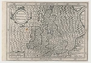
Anglia Scotia et Hibernia.
Erscheinungsdatum: 1639
Anbieter: Altea Antique Maps, London, Vereinigtes Königreich
Verbandsmitglied: ABA ILAB PBFA
Bewertung:
Karte
Amsterdam: Willem Blaeu, 1639. 100 x 135mm. Trimmed close to printed border on three sides, small spot in sea area. A map of the British Isles after Mercator, engraved by Hondius for his new edition of the Bertius 'Tabularum geographicarum contractarum' of 1616, which King describes as 'the finest set of miniature maps ever printed'. This example was issued in a Dutch pocket edition of 'Camden's Britannia'. Hondius (c.1594-1629) was the son of the Jodocus Hondius who engraved the John Speed county maps. He left the family business to set up on his own c.1621; after his early death many of his copper plates were sold to the rival Blaeu firm. SHIRLEY: British Isles 490; KING: Antique Miniature Maps p.96, from 'the finest set of miniature maps ever printed'.
-
Anglia Scotia et Hibernia.
Erscheinungsdatum: 1616
Anbieter: Altea Antique Maps, London, Vereinigtes Königreich
Verbandsmitglied: ABA ILAB PBFA
Bewertung:
Karte
Amsterdam, c.1616. Coloured. 100 x 135mm. A map of the British Isles after Mercator, engraved by Hondius for his new edition of the Bertius 'Tabularum geographicarum contractarum' of 1616, which King describes as 'the finest set of miniature maps ever printed'. Hondius (c.1594-1629) was the son of the Jodocus Hondius who engraved the John Speed county maps. He left the family business to set up on his own c.1621; after his early death many of his copper plates were sold to the rival Blaeu firm. SHIRLEY: British Isles 347; KING: Antique Miniature Maps p.96.
-
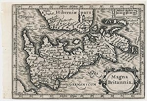
Magna Britannia.
Erscheinungsdatum: 1639
Anbieter: Altea Antique Maps, London, Vereinigtes Königreich
Verbandsmitglied: ABA ILAB PBFA
Bewertung:
Karte
Amsterdam: Willem Blaeu, 1639. 100 x 135mm. Trimmed close to printed border on three sides. A map of England, Wales, Scotland and the east of Ireland, orientated with north to the right. It was engraved by Jodocus Hondius II for a revised edition of the Bertius 'Tabularum geographicarum contractarum' of 1616, which King describes as 'the finest set of miniature maps ever printed'. This example was issued in a Dutch pocket edition of 'Camden's Britannia'. Hondius (c.1594-1629) was the son of the Jodocus Hondius who engraved the John Speed county maps. He left the family business to set up on his own c.1621; after his early death many of his copper plates were sold to the rival Blaeu firm. SHIRLEY: British Isles 1477-1650 492b; KING: Antique Miniature Maps p.96.
-
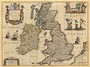
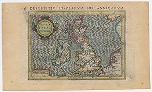
Magnae Britanniae et Hiberniae Tabula.
Erscheinungsdatum: 1633
Anbieter: Altea Antique Maps, London, Vereinigtes Königreich
Verbandsmitglied: ABA ILAB PBFA
Bewertung:
Karte
Amsterdam: Henricus Hondius, 1633, German text edition. Coloured. 380 x 510mm. A superb and detailed map of the British Isles, with three attractive Baroque title cartouches with swags and putti, one holding an inset of the Orkneys, the other two for the scale and title. This map was engraved in 1617 by the son of the Jodocus Hondius who engraved John Speed's county maps. Published separately, it originally had borders with ten costume vignettes and fourteen town plans, and is known by only two examples. In 1631 Jodocus's brother Henricus cut the borders off the printing plate so that it would fit into an atlas, adding his name and date, and issuing it in an 'Appendix' that year. This example comes from the next complete edition of the Mercator/Hondius two-volume atlas, 1633. SHIRLEY No. 435; KOEMAN: 1:311.1.