
Gesamtpreis (1 Artikel Artikel):
Versandziel:

MAP CARTOGRAPHY 19TH CENTURY O W GRAY TURKEY GREECE RUSSIA FRANCE (1 Ergebnisse)
Sie suchten nach:
Autor:
MAP CARTOGRAPHY 19TH CENTURY O W GRAY TURKEY GREECE RUSSIA FRANCE
Suche verfeinern
Direkt zu den wichtigsten Suchergebnissen
Produktart
- Alle Produktarten
- Bücher (1)
- Magazine & Zeitschriften
- Comics
- Noten
- Kunst, Grafik & Poster
- Fotografien
- Karten
-
Manuskripte &
Papierantiquitäten
Zustand
- Alle
- Neu
- Antiquarisch/Gebraucht
Einband
- alle Einbände
- Hardcover
- Softcover
Weitere Eigenschaften
- Erstausgabe
- Signiert
- Schutzumschlag
- Angebotsfoto
- Kein Print-on-Demand
Land des Verkäufers
Verkäuferbewertung
-
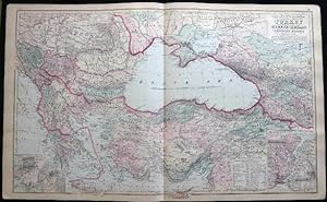
Original Double-Page Hand-Colored Gray's New Map of the Countries Surrounding the Black Sea, Comprising Turkey in Europe and Part of Turkey in Asia Greece (Hellas) Southern Russia Etc. By Frank Gray (and) Map of Russia (and) Map of France.
Verlag: O.W. Gray & Son, Philadelphia, PA, 1882
Erstausgabe
Not Bound. Zustand: Very Good. Map. One sheet, printed with 3 maps, from the 1882 O.W. Gray National Atlas, New York Edition: Double-page Gray's New Map of the Countries Surrounding the Black Sea, Comprising Turkey in Europe and Part of Turkey in Asia Greece (Hellas) Southern Russia Etc. with inset map of the Environs of Athens and Piraeus and inset of The Bosphorus or Strait of Constantinople By Frank A. Gray with the copyright of 1879 O.W. Gray & Son (and) Russia (and) France, with inset map of Corsica. With original hand-coloring in pastel tones and outlining in red; Approx. 28 1/2" x 17 1/4" overall size; a little even toning to the paper, margin with a few little edge & tip-nicks, tip bend; in very good condition.