
Gesamtpreis (1 Artikel Artikel):
Versandziel:

MERCATOR, GERARD & HONDIUS, JODOCUS (366 Ergebnisse)
Direkt zu den wichtigsten Suchergebnissen
Produktart
- Alle Produktarten
- Bücher (63)
- Magazine & Zeitschriften
- Comics
- Noten
- Kunst, Grafik & Poster (110)
- Fotografien
- Karten (193)
-
Manuskripte &
Papierantiquitäten
Zustand
- Alle
- Neu
- Antiquarisch/Gebraucht
Einband
- alle Einbände
- Hardcover (8)
- Softcover
Weitere Eigenschaften
- Erstausgabe (7)
- Signiert
- Schutzumschlag (1)
- Angebotsfoto (209)
- Kein Print-on-Demand
Gratisversand
Land des Verkäufers
Verkäuferbewertung
-
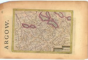
Argow (Aargau).
Verlag: LondonPrinted by T.Cotes for Michael Sparkes and Samuel Cartwright ., 1635
Anbieter: Robert Frew Ltd. ABA ILAB, London, Vereinigtes Königreich
Verbandsmitglied: ABA ILAB PBFA
Bewertung:

Karte
Original engraved map of Argau / Switzerland (map dimensions 19.2 x 14 cm, overall dimensions 29.5 x 18.5 cm) with later hand-colouring. Covering the area around the Lake Lucerne, Lake Zurich and Lake Thun. With English text to verso. A bit tanned and with a few small nicks to margins, generally very good. From "Historia Mundi or Mercator's Atlas .".
-
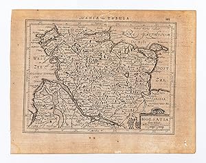
Holsatia ducatus.
Verlag: AmsterdamJansson., 1634
Anbieter: Robert Frew Ltd. ABA ILAB, London, Vereinigtes Königreich
Verbandsmitglied: ABA ILAB PBFA
Bewertung:
Karte
14.5 x 19.2 cm. Uncoloured. Single page map of Schleswig Holstein. Latin text on verso. Two very small holes to lower right margin though not affecting image. Generally in very good condition.
-
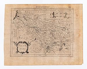
Picardia.
Verlag: AmsterdamJansson., 1634
Anbieter: Robert Frew Ltd. ABA ILAB, London, Vereinigtes Königreich
Verbandsmitglied: ABA ILAB PBFA
Bewertung:
Karte
14.5 x 18.7 cm. Uncoloured. Single page map of Picardy. Latin text on verso. Impression weaker at upper right corner. Some light soiling at margins, otherwise in good condition.
-

Bolonia et Guines com.
Verlag: AmsterdamJansson., 1634
Anbieter: Robert Frew Ltd. ABA ILAB, London, Vereinigtes Königreich
Verbandsmitglied: ABA ILAB PBFA
Bewertung:
Karte
14.6 x 18 cm. Uncoloured. Single page map of the region surrounding Boulogne. Latin text on verso. Small red mark to centre right of image. Some show through text, otherwise in good condition.
-
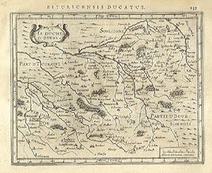
Le Duche D' Berry.
Verlag: AmsterdamJansson., 1634
Anbieter: Robert Frew Ltd. ABA ILAB, London, Vereinigtes Königreich
Verbandsmitglied: ABA ILAB PBFA
Bewertung:
Karte
14.4 x 18.1 cm. Uncoloured. Single page map. Latin text on verso. Very good condition.
-
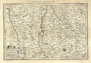
Lotharingia Septentrional.
Verlag: AmsterdamJansson., 1634
Anbieter: Robert Frew Ltd. ABA ILAB, London, Vereinigtes Königreich
Verbandsmitglied: ABA ILAB PBFA
Bewertung:
Karte
13.4 x 20.2 cm. Uncoloured. Single page map of northern Lorraine. Latin text on verso. Very good condition.
-
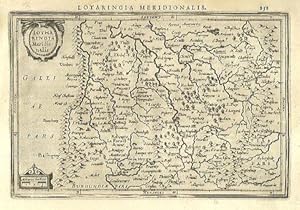
Lotharingia Meridionalis.
Verlag: AmsterdamJansson., 1634
Anbieter: Robert Frew Ltd. ABA ILAB, London, Vereinigtes Königreich
Verbandsmitglied: ABA ILAB PBFA
Bewertung:
Karte
13.4 x 19.9 cm. Uncoloured. Single page map of southern Lorraine. Latin text on verso. Light dampstain at upper left corner, otherwise in good condition.
-
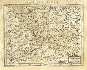
Westphalić tabula. II.
Verlag: AmsterdamJansson., 1634
Anbieter: Robert Frew Ltd. ABA ILAB, London, Vereinigtes Königreich
Verbandsmitglied: ABA ILAB PBFA
Bewertung:
Karte
13.7 x 17.7 cm. Uncoloured. Single page map of Westfalen and the Nord Rhein. Latin text on verso. Dampstaining across upper and right edges of sheet.
-
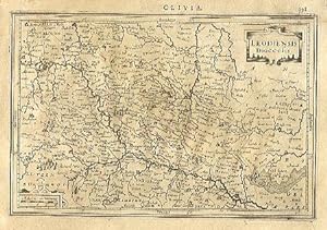
Leodiensis Diocesis.
Verlag: AmsterdamJansson., 1634
Anbieter: Robert Frew Ltd. ABA ILAB, London, Vereinigtes Königreich
Verbandsmitglied: ABA ILAB PBFA
Bewertung:
Karte
13.3 x 20 cm. Uncoloured. Single page map of the region of Liege. Latin text on verso. Light dampstain across sheet, otherwise browned overall.
-
Waldeck Comitatus.
Verlag: AmsterdamJansson., 1634
Anbieter: Robert Frew Ltd. ABA ILAB, London, Vereinigtes Königreich
Verbandsmitglied: ABA ILAB PBFA
Bewertung:
Karte
14.2 x 19.3 cm. Uncoloured. Single page map of the region surrounding Waldeck, northern Hessen. Latin text on verso. Light dampstain across upper and right edges of sheet.
-
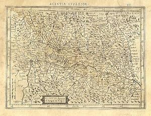
Alsatia superior cu Suntgoia & Brisgoia.
Verlag: AmsterdamJansson., 1634
Anbieter: Robert Frew Ltd. ABA ILAB, London, Vereinigtes Königreich
Verbandsmitglied: ABA ILAB PBFA
Bewertung:
Karte
14 x 19.1 cm. Uncoloured. Single page map of southern Alsace. Latin text on verso. Dampstain across upper and right edges of sheet, browned overall.
-
Saxonia Inferior et Meklenborg.
Verlag: AmsterdamJansson., 1634
Anbieter: Robert Frew Ltd. ABA ILAB, London, Vereinigtes Königreich
Verbandsmitglied: ABA ILAB PBFA
Bewertung:
Karte
14.2 x 20 cm. Uncoloured. Single page map showing what are now the regions of Schwerin, Rostock and Neubrandenburg. Latin text on verso. Dampstain across upper and right edges of sheet, browned overall.
-
Braunswyck et Meydburg cum confinis.
Verlag: AmsterdamJansson., 1634
Anbieter: Robert Frew Ltd. ABA ILAB, London, Vereinigtes Königreich
Verbandsmitglied: ABA ILAB PBFA
Bewertung:
Karte
14.1 x 19.3 cm. Uncoloured. Single page map of the regions of Braunschweig and Magdeburg. Latin text on verso. Dampstain across upper and right edges of sheet, browned overall.
-
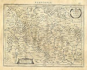
Franckenland.
Verlag: AmsterdamJansson., 1634
Anbieter: Robert Frew Ltd. ABA ILAB, London, Vereinigtes Königreich
Verbandsmitglied: ABA ILAB PBFA
Bewertung:
Karte
14 x 18.2 cm. Uncoloured. Single page map. Many place names underlined in pencil in an old hand. Latin text on verso. Light dampstain across upper and right edges of sheet, browned overall.
-
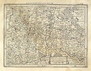
Palatinatus Bavariae.
Verlag: AmsterdamJansson., 1634
Anbieter: Robert Frew Ltd. ABA ILAB, London, Vereinigtes Königreich
Verbandsmitglied: ABA ILAB PBFA
Bewertung:
Karte
13.8 x 18.3 cm. Uncoloured. Single page map. Latin text on verso. Dampstain across upper and right edges of sheet, browned overall.
-
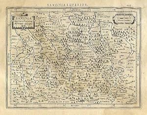
Saxonić Superioris Lusatić Misnieque descriptio.
Verlag: AmsterdamJansson., 1634
Anbieter: Robert Frew Ltd. ABA ILAB, London, Vereinigtes Königreich
Verbandsmitglied: ABA ILAB PBFA
Bewertung:
Karte
13.6 x 18.2 cm. Uncoloured. Single page map of Saxony and the surrounding regions. Latin text on verso. Dampstain across upper and right edges of sheet, browned overall.
-
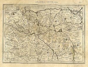
![Bild des Verkäufers für Saxonia Inferior et Mékléburg. / The Lower Saxonie. [Germany] zum Verkauf von Robert Frew Ltd. ABA ILAB](https://pictures.abebooks.com/inventory/md/md17237128780.jpg)
Saxonia Inferior et Mékléburg. / The Lower Saxonie. [Germany]
Verlag: Londonprinted by T.Cotes for Michael Sparkes and Samuel Cartwright., 1635
Anbieter: Robert Frew Ltd. ABA ILAB, London, Vereinigtes Königreich
Verbandsmitglied: ABA ILAB PBFA
Bewertung:
Karte
13.6 x 19.3 cm. Uncoloured. Single page of North Eastern Germany. English text on verso. Some offsetting. Impression faint. From "Historia Mundi or Mercator's Atlas .".
-
![Bild des Verkäufers für Saxonić Superioris Luatić, Misnićq des. / The Dukedome of the higher Saxonie. [Germany] zum Verkauf von Robert Frew Ltd. ABA ILAB](https://pictures.abebooks.com/inventory/md/md17237128781.jpg)
Saxonić Superioris Luatić, Misnićq des. / The Dukedome of the higher Saxonie. [Germany]
Verlag: Londonprinted by T.Cotes for Michael Sparkes and Samuel Cartwright., 1635
Anbieter: Robert Frew Ltd. ABA ILAB, London, Vereinigtes Königreich
Verbandsmitglied: ABA ILAB PBFA
Bewertung:
Karte
13.9 x 18.9 cm. Uncoloured. Single page map of South Eastern Germany. English text on verso. Minor offsetting. Impression faint to lower right corner. Very small rust mark to centre of image. From "Historia Mundi or Mercator's Atlas .".
-
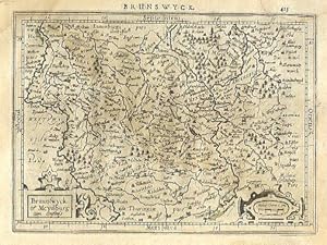
![Bild des Verkäufers für Brauswik et Meydburg cum confinijs. / The Dukedome of Brunswicke. [Germany] zum Verkauf von Robert Frew Ltd. ABA ILAB](https://pictures.abebooks.com/inventory/md/md17237128782.jpg)
Brauswik et Meydburg cum confinijs. / The Dukedome of Brunswicke. [Germany]
Verlag: Londonprinted by T.Cotes for Michael Sparkes and Samuel Cartwright., 1635
Anbieter: Robert Frew Ltd. ABA ILAB, London, Vereinigtes Königreich
Verbandsmitglied: ABA ILAB PBFA
Bewertung:
Karte
13.7 x 17.8 cm. Uncoloured. Single page map showing the region around Brunswick and Magdeburg. English text on verso. Minor offsetting. Impression faint to lower right corner. Very small rust mark to centre of image. From "Historia Mundi or Mercator's Atlas .".
-
![Bild des Verkäufers für Hassia Landgraviatus. / Hassia or the Landgraviate of Hessen. [Germany] zum Verkauf von Robert Frew Ltd. ABA ILAB](https://pictures.abebooks.com/inventory/md/md17237128785.jpg)
Hassia Landgraviatus. / Hassia or the Landgraviate of Hessen. [Germany]
Verlag: Londonprinted by T.Cotes for Michael Sparkes and Samuel Cartwright., 1635
Anbieter: Robert Frew Ltd. ABA ILAB, London, Vereinigtes Königreich
Verbandsmitglied: ABA ILAB PBFA
Bewertung:
Karte
13.5 x 17.7 cm. Uncoloured. Single page map. English text on verso. Slight offsetting though generally in good condition. From "Historia Mundi or Mercator's Atlas .".
-
![Bild des Verkäufers für Thuringia. / Thuringia or the Landgraviate of Duringen. [Germany] zum Verkauf von Robert Frew Ltd. ABA ILAB](https://pictures.abebooks.com/inventory/md/md17237128786.jpg)
Thuringia. / Thuringia or the Landgraviate of Duringen. [Germany]
Verlag: Londonprinted by T.Cotes for Michael Sparkes and Samuel Cartwright., 1635
Anbieter: Robert Frew Ltd. ABA ILAB, London, Vereinigtes Königreich
Verbandsmitglied: ABA ILAB PBFA
Bewertung:
Karte
13.9 x 17.9 cm. Uncoloured. Single page map. English text on verso. Slight offsetting though generally in good condition. From "Historia Mundi or Mercator's Atlas .".
-
![Bild des Verkäufers für Emden et Oldenbor. / The Countie of Embdanum and Oldenburg. [Germany] zum Verkauf von Robert Frew Ltd. ABA ILAB](https://pictures.abebooks.com/inventory/md/md17237128788.jpg)
Emden et Oldenbor. / The Countie of Embdanum and Oldenburg. [Germany]
Verlag: Londonprinted by T.Cotes for Michael Sparkes and Samuel Cartwright., 1635
Anbieter: Robert Frew Ltd. ABA ILAB, London, Vereinigtes Königreich
Verbandsmitglied: ABA ILAB PBFA
Bewertung:
Karte
12.9 x 18.7 cm. Uncoloured. Single page map. English text on verso. Some offsetting, more noticeable to lower edge, though generally in good condition. From "Historia Mundi or Mercator's Atlas .".
-
![Bild des Verkäufers für Wesphalia cum Dioecesi Bremensi. / The First Table of Westphalia. [Germany] zum Verkauf von Robert Frew Ltd. ABA ILAB](https://pictures.abebooks.com/inventory/md/md17237128789.jpg)
Wesphalia cum Dioecesi Bremensi. / The First Table of Westphalia. [Germany]
Verlag: Londonprinted by T.Cotes for Michael Sparkes and Samuel Cartwright., 1635
Anbieter: Robert Frew Ltd. ABA ILAB, London, Vereinigtes Königreich
Verbandsmitglied: ABA ILAB PBFA
Bewertung:
Karte
13.5 x 18.5 cm. Uncoloured. Single page map. English text on verso. English title to left margin slightly encroaching on to border of the map. Some offsetting, more noticeable to lower edge, though generally in good condition. From "Historia Mundi or Mercator's Atlas .".
-
![Bild des Verkäufers für Bavaria. / The Dukedome of Bavaria. [Germany] zum Verkauf von Robert Frew Ltd. ABA ILAB](https://pictures.abebooks.com/inventory/md/md17237128791.jpg)
Bavaria. / The Dukedome of Bavaria. [Germany]
Verlag: Londonprinted by T.Cotes for Michael Sparkes and Samuel Cartwright., 1635
Anbieter: Robert Frew Ltd. ABA ILAB, London, Vereinigtes Königreich
Verbandsmitglied: ABA ILAB PBFA
Bewertung:
Karte
13.9 x 18 cm. Uncoloured. Single page map showing part of southern Germany. English text on verso. Library stamp to upper left margin, not affecting image. Slight offsetting though generally in good condition. From "Historia Mundi or Mercator's Atlas .".
-
![Bild des Verkäufers für Westphalić tabula II. / The Second Table of Westphalia. [Germany] zum Verkauf von Robert Frew Ltd. ABA ILAB](https://pictures.abebooks.com/inventory/md/md17237128792.jpg)
Westphalić tabula II. / The Second Table of Westphalia. [Germany]
Verlag: Londonprinted by T.Cotes for Michael Sparkes and Samuel Cartwright., 1635
Anbieter: Robert Frew Ltd. ABA ILAB, London, Vereinigtes Königreich
Verbandsmitglied: ABA ILAB PBFA
Bewertung:
Karte
13 x 18 cm. Uncoloured. Single page map. English text on verso. Slight offsetting though generally in good condition. From "Historia Mundi or Mercator's Atlas .".
-
![Bild des Verkäufers für Monasteriensis Episcopatus. / The Bishopricke of Munster. [Germany] zum Verkauf von Robert Frew Ltd. ABA ILAB](https://pictures.abebooks.com/inventory/md/md17237128793.jpg)
Monasteriensis Episcopatus. / The Bishopricke of Munster. [Germany]
Verlag: Londonprinted by T.Cotes for Michael Sparkes and Samuel Cartwright., 1635
Anbieter: Robert Frew Ltd. ABA ILAB, London, Vereinigtes Königreich
Verbandsmitglied: ABA ILAB PBFA
Bewertung:
Karte
16.2 x 23.1 cm. Uncoloured. Single page map showing the region of Munster, north western Germany. English text on verso. Tears with some loss of image to lower edge. Some offsetting. English title to left edge encroaching on to image. From "Historia Mundi or Mercator's Atlas .".
-
![Bild des Verkäufers für Palatinate Bavaria. / The Palatinate of the lower Bavaria. [Germany] zum Verkauf von Robert Frew Ltd. ABA ILAB](https://pictures.abebooks.com/inventory/md/md17237128794.jpg)
Palatinate Bavaria. / The Palatinate of the lower Bavaria. [Germany]
Verlag: Londonprinted by T.Cotes for Michael Sparkes and Samuel Cartwright., 1635
Anbieter: Robert Frew Ltd. ABA ILAB, London, Vereinigtes Königreich
Verbandsmitglied: ABA ILAB PBFA
Bewertung:
Karte
13.5 x 17.9 cm. Uncoloured. Single page map showing part of Bavaria. English text on verso. Impression slightly faded to lower left corner. Slight offsetting. From "Historia Mundi or Mercator's Atlas .".
-
![Bild des Verkäufers für Westphalić tabula tertia. / The third table of Westphalia. [Germany] zum Verkauf von Robert Frew Ltd. ABA ILAB](https://pictures.abebooks.com/inventory/md/md17237128795.jpg)
Westphalić tabula tertia. / The third table of Westphalia. [Germany]
Verlag: Londonprinted by T.Cotes for Michael Sparkes and Samuel Cartwright., 1635
Anbieter: Robert Frew Ltd. ABA ILAB, London, Vereinigtes Königreich
Verbandsmitglied: ABA ILAB PBFA
Bewertung:
Karte
13.7 x 19.9 cm. Uncoloured. Single page map. English text on verso. Slight offsetting though generally in good condition. From "Historia Mundi or Mercator's Atlas .".
-
![Bild des Verkäufers für Westphalia Ducatus. / The Fourth Table of Westphalia. [Germany] zum Verkauf von Robert Frew Ltd. ABA ILAB](https://pictures.abebooks.com/inventory/md/md17237128796.jpg)
Westphalia Ducatus. / The Fourth Table of Westphalia. [Germany]
Verlag: Londonprinted by T.Cotes for Michael Sparkes and Samuel Cartwright., 1635
Anbieter: Robert Frew Ltd. ABA ILAB, London, Vereinigtes Königreich
Verbandsmitglied: ABA ILAB PBFA
Bewertung:
Karte
16.7 x 23.7 cm. Uncoloured. Single page map. English text on verso. Upper margin cropped to edge of image. Slight offsetting though generally in good condition. From "Historia Mundi or Mercator's Atlas .".
-
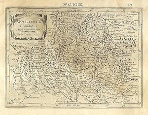
![Bild des Verkäufers für Waldek Comit. / The Countie of Waldeck. [Germany] zum Verkauf von Robert Frew Ltd. ABA ILAB](https://pictures.abebooks.com/inventory/md/md17237128799.jpg)
Waldek Comit. / The Countie of Waldeck. [Germany]
Verlag: Londonprinted by T.Cotes for Michael Sparkes and Samuel Cartwright., 1635
Anbieter: Robert Frew Ltd. ABA ILAB, London, Vereinigtes Königreich
Verbandsmitglied: ABA ILAB PBFA
Bewertung:
Karte
13.5 x 17.6 cm. Uncoloured. Single page map. English text on verso. Slight offsetting though generally in good condition. From "Historia Mundi or Mercator's Atlas .".