Gesamtpreis (1 Artikel Artikel):
Versandziel:

MOLL, HERMANN (69 Ergebnisse)
Direkt zu den wichtigsten Suchergebnissen
Produktart
- Alle Produktarten
- Bücher (49)
- Magazine & Zeitschriften
- Comics
- Noten
- Kunst, Grafik & Poster (1)
- Fotografien
- Karten (19)
-
Manuskripte &
Papierantiquitäten
Zustand
Einband
Weitere Eigenschaften
Gratisversand
Land des Verkäufers
Verkäuferbewertung
-

Alte Bräuche frohe Feste zwischen Flensburg und Obersdorf, Aachen und Bayreuth. Softcover
Verlag: Allianz / Mairs Geographischer Verlag, Ostfildern, 1984
Buch
Softcover. Zustand: SEHR GUT. 430 g. Mit Karte im Nachsatz. Eine Fülle von Abbildungen un deine mit Anmerkungen versehene Landkarte veranschaulichen den informativen Text. deutsch 240 pages.
-
Hardcover. Zustand: Used; Good. Dispatched, from the UK, within 48 hours of ordering. This book is in good condition but will show signs of previous ownership. Please expect some creasing to the spine and/or minor damage to the cover.
Mehr Angebote von anderen Verkäufern bei AbeBooks
Neu ab EUR 64,07
Gebraucht ab EUR 2,34
Mehr entdecken Hardcover
-
![Bild des Verkäufers für Geographia classica emendata, ex Graecorum latinorumque authoribus antiquis ubi tabellis XXXII veterum locorum appellationes geographiae recentissimae et accuratissimae summa cum diligentia accommodantur 1721 [LeatherBound] zum Verkauf von True World of Books](https://pictures.abebooks.com/inventory/md/md31616639321.jpg)
LeatherBound. Zustand: New. LeatherBound edition. Condition: New. Reprinted from edition. Leather Binding on Spine and Corners with Golden leaf printing on spine. Bound in genuine leather with Satin ribbon page markers and Spine with raised gilt bands. A perfect gift for your loved ones. NO changes have been made to the original text. This is NOT a retyped or an ocr'd reprint. Illustrations, Index, if any, are included in black and white. Each page is checked manually before printing. As this print on demand book is reprinted from a very old book, there could be some missing or flawed pages, but we always try to make the book as complete as possible. Fold-outs, if any, are not part of the book. If the original book was published in multiple volumes then this reprint is of only one volume, not the whole set. Sewing binding for longer life, where the book block is actually sewn (smythe sewn/section sewn) with thread before binding which results in a more durable type of binding. Pages: 163.
-
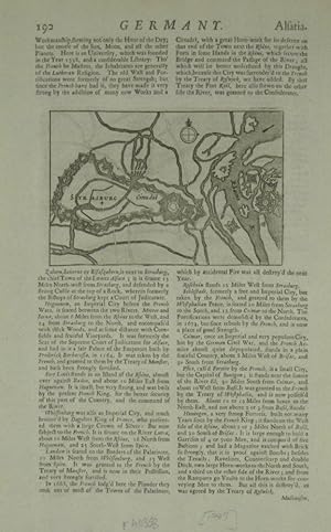
Strasburg.
Verlag: London:, 1709
Anbieter: Robert Frew Ltd. ABA ILAB, London, Vereinigtes Königreich
Verbandsmitglied: ABA ILAB PBFA
Bewertung:

Karte
8.9 x 13.4 cm, sheet size 32 x 21 cm. Uncoloured. Engraved plan showing the fortifications of the city. Printed text above, below and on verso of image. Good condition.
-

Die Kreis Altenaer Eisenbahn. (KAE)
Verlag: Freiburg, Eisenbahn-Kurier, 1983
ISBN 10: 3882555416ISBN 13: 9783882555417
Buch Erstausgabe
mit sehr vielen Abbildungen. * EA. umfangreiche Dokumentation. ** sehr gut erhalten ! ISBN 3882555416 ANY QUESTIONS ?? Please don t hesitate to ask for details !! Sprache: Deutsch Gewicht in Gramm: 1200 ill. OPbd. (Glanzpappe), 312 S., Gr.8°, 1. Aufl.
-
15 Bücher: Nachts wenn das Licht ausgeht + Inspektor Thomsen geht zur Schule + An der schönen blauen Donau + Solange die Spur warm ist + Kriminalfälle ohne Beispiel + Orpheus im Frack + Die dunkle Grenze + Das Geheimnis des Wachsfigurenkabinetts + Galgenfriest + Monsieur bleibt im Schatten + Das graue Zimmer + Spione am Laufsteg + Warum starb Angele + Die deutsche Kriminalerzählung von Schiller bis zur Gegenwart Band 2 und Band 3
Verlag: verschiedene Verlage
Anbieter: Versandantiquariat Kerzemichel, Wittenberge, Deutschland
Bewertung:
alle Bücher 8°, Einbände z. T. berieben bzw. leicht randrissig, einige haben farbigen Kopfschnitt, guter Zustand, über 1000 g.
-
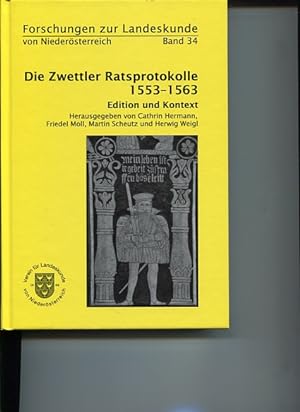
Das Zwettler Ratsprotokoll 1553 - 1563. Edition und Kontext. Verein für Landeskunde von Niederösterreich - St. Pölten. Hrsg. von Cathrin Hermann ., Forschungen zur Landeskunde von Niederösterreich Band 34.
Verlag: St. Pölten: Verein für Landeskunde von Niederösterr., 2010
ISBN 10: 3901234179ISBN 13: 9783901234170
Buch
8° , Hardcover/Pappeinband. Zustand: Gut. Erstauflage, EA,. 387 S.; Illustr; 24 cm, zahlreiche Abbildungen, sehr guter Zustand Sprache: Deutsch Gewicht in Gramm: 1055.
-
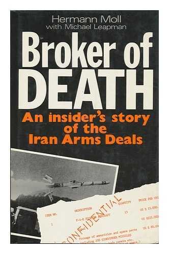
Broker of Death
Verlag: MacMillan London 1988, 1988
Anbieter: Andrew Barnes Books / Military Melbourne, Melbourne, VIC, Australien
Bewertung:

Erstausgabe
1st edition dust jacket Fine octavo xi + 198pp., appendix, index, An insider's story of the Iran Arms Deals.
-
Eisenbahn-Kurier, ., 1983, , 311, Hardcover (gebunden), 8°, ohne Schutzumschlag, , Einband: minimal bestoßen, minimal fleckig, Seiten: minimal gebräunt,
-
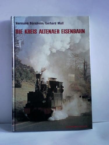
Die Kreis Altenaer Eisenbahn.
Verlag: Freiburg Breisgau. Eisenbahn-Kurier. 1983., 1982
ISBN 10: 3882555416ISBN 13: 9783882555417
Buch
311 S. Hardcover. Sauberes Exemplar ohne Stempel und Anstreichungen. Gut erhalten. Zahlreiche Abbildungen und Tafeln. Sprache: deu.
Mehr Angebote von anderen Verkäufern bei AbeBooks
Gebraucht ab EUR 29,00
Mehr entdecken Hardcover Softcover Erstausgabe
-
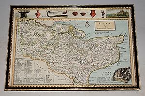
Original Engraved Map of KENT. Showing Divisions and Hundreds.
Verlag: H. Moll Ca 1724, 1724
Anbieter: PROCTOR / THE ANTIQUE MAP & BOOKSHOP, DORCHESTER, Vereinigtes Königreich
Verbandsmitglied: PBFA
Bewertung:
Karte
In black and gilt wooden frame, with glass. Size of engraved surface 12.5 x 8.5 inches. Frame 13 x 9.5 inches. In very good condition. Vertical crease to centre. A very bright and clean map. With archaeological and historical illustrations to the borders including vignettes of The Royal Observatory as Greenwich and Dover Castle as wel as Roman Antiquities from Reculver and 'A British Monument' called Kitt Coty House at Maidstone. Engraved by the Dutch cartographer Herman Moll.
-
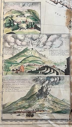
Left bottom piece of Herman Moll's map op Italy. Coloured engraving of a Cataract of Air on Mount Aeolius, The eruoption of Mount Vesuvius and Mt. Aetna.Some browning on the right side just outside the illustrations. Total: 640 x 280 mm.Moll was a Dutch emigrant who came to London about 1680 following the Scanian Wars, he first worked as an engraver for Moses Pitt, later setting up his own business and becoming, after the turn of the century, the foremost map publisher in England. Moll was at the forefront of map making during his working life and his maps reflect his ever inquisitive nature.[NL] Decoratieve gekleurde gravures van de vulkaan Vesuvius and Etna and mount Aeolius. Linkerstuk van de kaart van Italië door Hermann Moll uit 1726. .
-
A Map of Zaara. Negroe-Land. Guinea
Verlag: Artist: Moll Hermann ( - 1732 ) London ; issued in: Paris ; ca: 1719; - Hermann Moll (1654- 1732) London was a cartographer engraver and publisher Moll produced his earliest maps from studying cartographers such as John Senex and Emanuel Bowen_ In the 1690s Moll worked mainly as an engraver for Christopher Browne Robert Morden and Lea in whose business he was also involved During this time he also published his first major independent work the Thesaurus Geographicus The success of this work likely influenced his decision to start publishing his own maps For the production of his maps Moll relied on the most accurate geographical information possible from first hand Moll benefited from his acquaintance with circumnavigator and privateer Will, 1654
Anbieter: Antique Sommer& Sapunaru KG, München, Deutschland
Bewertung:
Technic: Copper print; colorit: colored; condition: Perfect condition, size (in cm): 17 x 19,5 cm; - Map shows the region of West Africa and a partial map with Cape Verde. At that time, this region in West Africa was called Nigrites (English Negroland, French Nigritie, Latin Nigritia). Of the western part of Africa, the coastal regions had been explored somewhat more thoroughly, while little was known about the interior. Thus Negroe Land corresponds to the imagination of European cartographers.
-
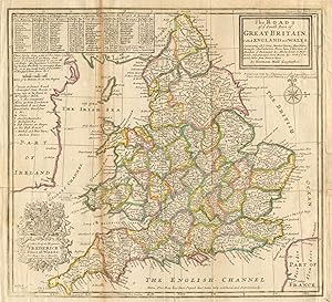
Zustand: Good. 'The Roads of ye South Part of Great Britain'. England & Wales. MOLL 1753 map. Antique copperplate map with original outline colour; Hermann Moll (1753). 32.0 x 28.5cm, 12.5 x 11.25 inches; this is a folding map. Condition: Good. The image shown may have been taken from a different example of this map than that which is offered for sale. The map you will receive is in good condition but there may be minor variations in the condition from that shown in the image. This map was coloured by hand at the time of publication, thus the colouration may vary slightly between different examples of the map; the colouring applied to the map you receive may differ slightly from that shown in the image. Minor repairs have been made verso and in the margin. There is nothing printed on the reverse side, which is plain.
-
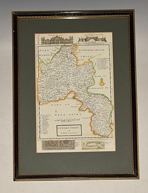
Original Engraved Map of Oxfordshire OXFORD. Showing Divisions and Hundreds.
Verlag: H. Moll Ca 1724, 1724
Anbieter: PROCTOR / THE ANTIQUE MAP & BOOKSHOP, DORCHESTER, Vereinigtes Königreich
Verbandsmitglied: PBFA
Bewertung:
Karte
In black and gilt wooden frame, with glass. Size of engraved surface 12 x 7.5 inches. Frame 17 x 12 inches. In very good condition. A very bright and clean map. Detailed and highly decorative early 18th century map of Oxfordshire by Herman Moll. Features archaeological and historical illustrations to the borders including Blenheim House, The Bridge of Blenheim, Roman Pavement at Woodstock and Rollewrich Stones Engraved by the Dutch cartographer Herman Moll.
-
Zustand: Good. "The North Riding of York Shire", by Hermann Moll. Yorkshire 1724 old map. Antique hand coloured map; Hermann Moll (1724). 33.5 x 21.5cm, 13 x 8.5 inches. Condition: Good. There is nothing printed on the reverse side, which is plain.
-
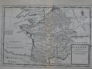
28 x 18,5 cm Gallia Vetus ad Julli Caesaris, Original Landkarte, Kupferstich von Hermann Moll (deutsch-holländischer Geograph, der etwas 1698-1732 in London arbeitete); 22,5 x 15,5 cm, Blattgröße 28 x 18,5 cm, guter Zustand. Sprache: Deutsch Gewicht in Gramm: 550.
-
Moll, Hermann, Die Insel Madagascar, c. 1720, gerahmt, Form. Kart 14 x 10,5 cm, gerahmt 21,5 x 18 cm, Zustand sehr gut Sprache: Deutsch.
-
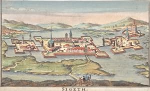
Sigeth.
Verlag: Artist: Moll Hermann ( - 1732 ) London ; issued in: London ; ca: 1712; - Hermann Moll (1654- 1732) London was a cartographer engraver and publisher Moll produced his earliest maps from studying cartographers such as John Senex and Emanuel Bowen_ In the 1690s Moll worked mainly as an engraver for Christopher Browne Robert Morden and Lea in whose business he was also involved During this time he also published his first major independent work the Thesaurus Geographicus The success of this work likely influenced his decision to start publishing his own maps For the production of his maps Moll relied on the most accurate geographical information possible from first hand Moll benefited from his acquaintance with circumnavigator and privateer Wil, 1654
Anbieter: Antique Sommer& Sapunaru KG, München, Deutschland
Bewertung:
Technic: Copper print; colorit: original colored; condition: Margins cutted, size (in cm): 18 x 13 ,5; - Szietvar is a town in Baranya County in southern Hungary. The town's fortress was the setting of the Battle of Szigetvár in 1566. It was a sanjak centre at first in Budin Province (1566?1601), later in Kanije Province (1601?1689).
-
Scrap Book Collection of 65 views and maps of Berkshire
Verlag: Unpublished 1747-1821, 1747
Karte Erstausgabe
, assembled from a number of sources, including Moll's map of Berkshire, engraved views originally by Corbould, Thomas Hearne and others, including Windsor Castle, Donnington Castle, Donnington Grove, the Tythe Barn at Cholsey, one water colour of Windsor, a unique collection, folding plan of Windsor Castle (1749), dates given 1747 - 1821 First Edition , ex-library copy with labels at front endpapers and small stamps on reverse of some leaves, front hinge cracked and spine detaching from text block, small paper number label at lower spine, head of spine scuffed, boards rubbed and lightly marked, corners bumped, small owner's signature on front pastedown, some illustrations lightly foxed but most are clean, in fair condition , dark green cloth Quarto Hardback ISBN:
-

Moll, Hermann, c. 1740, The Scots settlement in America called New Caledonia, A.D. 1609, according to an org. draught by H. Moll, Geographer, c. 1740 Form. ca. 30 x 22,5 cm altersgem. sehr guter Zustand rare Karte Panama Sprache: Deutsch Gewicht in Gramm: 550.
-
Moll, Hermann, c. 1740, The Scots settlement in America called New Caledonia, A.D. 1609, according to an org. draught by H. Moll, Geographer, c. 1740 Form. ca. 30 x 22,5 cm altersgem. sehr guter Zustand rare Karte Panama Sprache: Deutsch Gewicht in Gramm: 550.
-
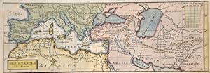
Orbis Tabula ad Justimum
Verlag: Artist: Moll Hermann ( - 1732 ) London ; issued in: London ; ca: 1715; - Hermann Moll (1654- 1732) London was a cartographer engraver and publisher Moll produced his earliest maps from studying cartographers such as John Senex and Emanuel Bowen_ In the 1690s Moll worked mainly as an engraver for Christopher Browne Robert Morden and Lea in whose business he was also involved During this time he also published his first major independent work the Thesaurus Geographicus The success of this work likely influenced his decision to start publishing his own maps For the production of his maps Moll relied on the most accurate geographical information possible from first hand Moll benefited from his acquaintance with circumnavigator and privateer Wil, 1654
Anbieter: Antique Sommer& Sapunaru KG, München, Deutschland
Bewertung:
Technic: Copper print; colorit: colored; condition: Upper margin perfectly replaced, size (in cm): 8,5 x 25,5; - Map shows the Mediterranean sea with sout Europe, north Africa and Asia minor.
-
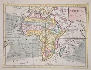
Africa. By H. Moll Geographer.
Verlag: Artist: Moll Hermann ( - 1732 ) London ; issued in: London ; ca: 1714; - Hermann Moll (1654- 1732) London was a cartographer engraver and publisher Moll produced his earliest maps from studying cartographers such as John Senex and Emanuel Bowen_ In the 1690s Moll worked mainly as an engraver for Christopher Browne Robert Morden and Lea in whose business he was also involved During this time he also published his first major independent work the Thesaurus Geographicus The success of this work likely influenced his decision to start publishing his own maps For the production of his maps Moll relied on the most accurate geographical information possible from first hand Moll benefited from his acquaintance with circumnavigator and privateer Wil, 1654
Anbieter: Antique Sommer& Sapunaru KG, München, Deutschland
Bewertung:
Technic: Copper print; colorit: original colored; condition: Perfect condition, size (in cm): 20 x 26; - Map depicts the continent of Africa and the winds at sea. With the island of Madagaskar and the Canaries islands.
-
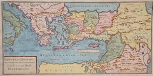
Scriptural Geography Containing the Places mentionednin the Old and New Testaments
Verlag: Artist: Moll Hermann ( - 1732 ) London ; issued in: London ; ca: 1712; - Hermann Moll (1654- 1732) London was a cartographer engraver and publisher Moll produced his earliest maps from studying cartographers such as John Senex and Emanuel Bowen_ In the 1690s Moll worked mainly as an engraver for Christopher Browne Robert Morden and Lea in whose business he was also involved During this time he also published his first major independent work the Thesaurus Geographicus The success of this work likely influenced his decision to start publishing his own maps For the production of his maps Moll relied on the most accurate geographical information possible from first hand Moll benefited from his acquaintance with circumnavigator and privateer Wil, 1654
Anbieter: Antique Sommer& Sapunaru KG, München, Deutschland
Bewertung:
Technic: Copper print; colorit: original colored; condition: Lower right and upper left corner perfectly restored, size (in cm): 16 x 32,5; - Map shows the south eastern part of Europe and the Mediterranean sea with Italy, Greece, Turkey with Cyprus and north Africa, Egypt and Israel.
-
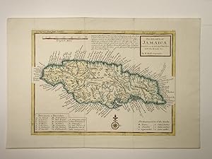
The Island of Jamaica. Divided into ist Principal Parishes with the Roads & c. Kartenblatt aus dem Atlas Minor.
Verlag: Cornhill Bowles, 1728
Anbieter: Versandantiquariat Christine Laist, Seeheim-Jugenheim, Deutschland
Bewertung:
Handkolorierte O-Karte der Insel Jamaika auf festem Papier mit zwei Faltungen im Blatt. Blatt sauber. Blattgröße: 24,5 x 36,5 cm. Kartengröße: 27,4 x 19,9 cm.
-
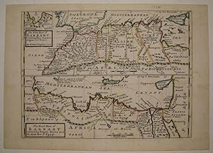
The West Part of Barbary Containing Fez, Marocco Algiers and Tunis and The East Part of Barbary containing Tripoli Barca and the North Part of Egypt
Verlag: London, 1732
Anbieter: Argosy Book Store, ABAA, ILAB, New York, NY, USA
Bewertung:
unbound. Zustand: very good. Map. Copper plate engraving with original hand outline. Image measures 7 15/16" x 10.75". Fine antique map in two sections showing the northern coast of Africa from Morocco and the Strait of Gibraltar to Cyprus and the Red Sea. In addition to political boundaries and geographical features, Moll includes a few cultural and historical descriptions. Of Malta he writes "subject to a Grand Master who is always at war with the Turks", and he notes the pyramids and locations of castles and villages. A small inset at top left shows the Port of Oran.Herman Moll (c. 1654-1732) settled in London in the 1670's where he worked as an engraver for Moses Pitt. By the turn of the century, Moll became the foremost map publisher in England, where he produced Atlases and maps. As an engraver, cartographer, mapseller and globemaker he appealed to the public with his unusual views and vignettes. As the demand for his work was sustained, he issued many revised editions of his work.
-
The World in Planisphere.
Verlag: London:, 1705
Anbieter: Robert Frew Ltd. ABA ILAB, London, Vereinigtes Königreich
Verbandsmitglied: ABA ILAB PBFA
Bewertung:
Karte
16.4 x 19.1, sheet size 32 x 21 cm. Double hemisphere map of the world with an inset of the northern hemisphere to the upper cusp. Printed text above image and on verso. Good condition.
-
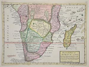
The South Part of Africa, and the Island Madagascar.
Verlag: Artist: Moll Hermann ( - 1732 ) London ; issued in: London ; ca: 1700; - Hermann Moll (1654- 1732) London was a cartographer engraver and publisher Moll produced his earliest maps from studying cartographers such as John Senex and Emanuel Bowen_ In the 1690s Moll worked mainly as an engraver for Christopher Browne Robert Morden and Lea in whose business he was also involved During this time he also published his first major independent work the Thesaurus Geographicus The success of this work likely influenced his decision to start publishing his own maps For the production of his maps Moll relied on the most accurate geographical information possible from first hand Moll benefited from his acquaintance with circumnavigator and privateer Wil, 1654
Anbieter: Antique Sommer& Sapunaru KG, München, Deutschland
Bewertung:
Technic: Copper print; colorit: colored; condition: Perfect condition, size (in cm): 20,5 x 27,5 cm; - Map shows Southern Africa up to the equator with Madagascar, the Amirantes, Mauritius and Reunion Island in the Indian Ocean.
-
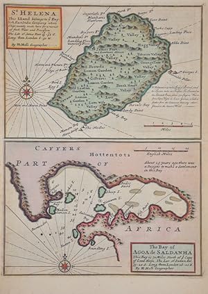
St. Helena / The bay of Agoa de Saldanha
Verlag: Artist: Moll Hermann ( - 1732 ) London ; issued in: London ; ca: 1712; - Hermann Moll (1654- 1732) London was a cartographer engraver and publisher Moll produced his earliest maps from studying cartographers such as John Senex and Emanuel Bowen_ In the 1690s Moll worked mainly as an engraver for Christopher Browne Robert Morden and Lea in whose business he was also involved During this time he also published his first major independent work the Thesaurus Geographicus The success of this work likely influenced his decision to start publishing his own maps For the production of his maps Moll relied on the most accurate geographical information possible from first hand Moll benefited from his acquaintance with circumnavigator and privateer Wil, 1654
Anbieter: Antique Sommer& Sapunaru KG, München, Deutschland
Bewertung:
Technic: Copper print; colorit: original colored; condition: Very good, size (in cm): 27,5 x 20; - Map shows the island Saint Helena and the bay of Agoa Saldanha near the Cape of Good Hope.