Gesamtpreis (1 Artikel Artikel):
Versandziel:

MORSE, JEDIDIAH & SIDNEY E (5 Ergebnisse)
Direkt zu den wichtigsten Suchergebnissen
Produktart
- Alle Produktarten
- Bücher (5)
- Magazine & Zeitschriften
- Comics
- Noten
- Kunst, Grafik & Poster
- Fotografien
- Karten
-
Manuskripte &
Papierantiquitäten
Zustand
- Alle
- Neu
- Antiquarisch/Gebraucht
Einband
- alle Einbände
- Hardcover (4)
- Softcover
Weitere Eigenschaften
- Erstausgabe
- Signiert
- Schutzumschlag
- Angebotsfoto (3)
- Kein Print-on-Demand
Land des Verkäufers
Verkäuferbewertung
-

A NEW SYSTEM OF GEOGRAPHY, ANCIENT AND MODERN, FOR THE USE OF SCHOOLS.
Verlag: Richardson & Lord, Boston, 1822
Hardcover. Zustand: Good. 378 pp., Half Brn Leather & Marbled Bds, Maroon Spine Label, Gilt title & Horizontal Lines on Spine, Strong edgewear, paper darkened & foxed else Good, 23rd ed (Makes good Shelf Appearance.
-
A new system of geography, ancient and modern : for the use of schools : accompanied with an atlas, adapted to the work.
Verlag: Boston : Published by Richardson & Lord, 75 Cornhill ; J. H. A. Frost, Printer, Congress Street, 1824, 1822., 1824
Hardcover. Zustand: Poor. 23rd edition ; ix, 360 pp. ; 18 cm. ; LC: G125; Dewey: 910 ; OCLC: 16067752 ; "Dr. Morse's career as a Geographer commenced as early as the winter of 1783-84, while he was teaching a school in New Haven, and pursuing at the same time the study of Theology. The English Geography by Guthrie was the only Compend then in use in any of our schools; and that was lamentably deficient in what related to our own country. To supply this deficiency he gathered information from all the sources within his reach, and imparted it in lectures to his pupils. Aware that the same need was felt in other schools, he was led to frame the substance of his lectures into a book; and this was published in 1784,-the first Geography of any kind ever published in Am erica. It was a duodecimo of two hundred and fourteen pages, entitled 'Geography made easy.' This, taken in connection with his subsequent efforts in the same direction, fairly entitles him to the distinction of being the Father of American Geography." -- from The Life of Jedidiah Morse, D.D. By William Buell Sprague, 1874. ; 1/4 leather and marbled paper boards ; repairs to covers ; previous owner John T. Slater's writing on endpapers states "This book was bought in Ganesville [sic] February 16, 1829. Make good use of this book" ; Contents: Astronomy -- Globes -- Maps -- Earth -- America -- North America -- Greenland -- Russian Settlements -- Brttish America -- Newfoundland -- Nova Scotia -- New Brunswick -- Lower Canada -- Upper Canada -- New Britain -- United States -- Eastern States -- Maine -- New-Hampshire -- Vermont . -- Massachusetts -- Rhode Island -- Connecticut -- Middle States -- New York -- New Jersey -- Pennsylvania -- Delaware -- Maryland -- District of Columbia -- Southern States -- Virginia -- North Carolina -- South Carolina -- Georgia -- Alabama -- Mississippi -- Louisiana -- Western States -- Tennessee -- Kentucky -- Ohio -- Indiana -- Illinois -- Missouri -- Michigan Territory -- Northwest Territory -- Arkansas Territory -- Missouri Territory -- Florida -- Mexico or New Spain -- Guatimala -- West Indies -- The Bahamas -- Cuba, Hispaniola -- Jamaica, Porto Rico -- Burmudas Islands -- South America -- Republic of Columbia -- Guiana -- Peru -- Brazil -- Buenos Ayres -- Chili -- Patagonia -- Europe -- England and Wales -- Scotland -- Ireland -- Lapland -- Norway -- Sweden -- Denmark -- Russia in Europe -- Prussia -- Austria -- Germany -- Saxony -- Hanover -- Bavaria -- Wirtemberg -- Baden -- Poland -- Switzerland -- Netherlands -- France -- Spain -- Portugal -- Italy -- Ionian Republic -- Turkey in Europe -- Asia -- Turkey in Asia -- Russia in Asia -- Arabia -- Persia -- Independent Tartary -- Hindoostan -- Farther India -- China -- Chinese Tartary -- Tributary States -- Japan -- Asiatic Islands -- Isles of Sunda -- Borneo -- Philippine Islands -- Celebes -- Spice Islands -- Australasia -- Polynesia -- Africa -- Egypt -- Barbary States -- Tripoli -- Tunis -- Algiers -- Morocco -- West Africa -- South Africa -- East Africa -- Nubia -- Abyssinia -- Central Africa -- African Islands.; POOR. Book.
-
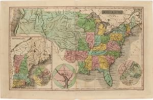
A New Universal Atlas of the World; Comprising, in Twenty Maps, Carefully Prepared from the Latest Information, and Neatly Engraved, The World, It's Several Grand Divisions, and Principal Subdivision
Verlag: Howe & Spalding, New Haven, 1822
Anbieter: Yesterday's Gallery, ABAA, East Woodstock, CT, USA
Bewertung:

Hardcover. Quarto, leather spine and marbled boards. 20 engraved, hand colored maps, including a double page folding map of the United States. Two of the maps (South America and Europe) have closed tears of approximately 2 inches. The map of the United States is reinforced with museum tape at the folds. The maps are time toned and some have light foxing but are overall in very good and very attractive shape. Very good hardcover.
-
A New Universal Atlas of the World; Comprising, in Twenty Maps, Carefully Prepared From the Latest Information, and Neatly Engraved, The World, Its Several Grand Divisions, and Principal Subdivisions
Verlag: Howe & Spalding, New Haven, 1822
Anbieter: Yesterday's Gallery, ABAA, East Woodstock, CT, USA
Bewertung:
Hardcover. Large Quarto, 11 x 9 1/2 inches. 1/4 red leather spine over marbled boards, gilt decorations at spine, color maps with one fold out of the United States. 'The double-page map of the United States, engraved by A. Doggett, is similar to the one engraved by N. & S.S. Jocelyn and published in Morse's An Atlas of the United States [1823] and New Universal Atlas of the World [1825], which is cited by Wheat. This earlier map is not mentioned. The map features the Oregon country with the overly-long Multnomah (Willamette) River. There is no northern boundary shown, although the map of North America shows the correct boundary to the Pacific. In the west, which is mostly labeled Unexplored Country, a dotted line connects a lake in the vicinity of Salt Lake to the Pacific accompanied by a note, 'Supposed River between the Buenaventara and the Bay of Francisco which will probably be the communication between the Atlantic and the Pacific.' (Old World Auctions) Jedidiah Morse was a notable geographer whose textbooks became a staple for students in the United States. He was the father of telegraphy pioneer and painter Samuel F. B. Morse, and his textbooks earned him the sobriquet of 'father of American geography.' Good to Very Good, marbled boards heavily rubbed with some spotting, corners and spine ends bumped, rubbing to leather spine and gilt is hard to see, front hinge starting to crack, lacks front free end paper, pages foxed and agetoned, map of South America has 2 x 3 inch tear at top inner corner with some creasing, map of Europe has two inch closed tear at fore-edge, one inch chip at fore-edge of rear free end paper.
-
A NEW UNIVERSAL ATLAS OF THE WORLD COMPRISING IN TWENTY ONE MAPS, CAREFULLY PREPARED FROM THE LATEST INFORMATION AND NEATLY ENGRAVED, THE WORLD, ITS SEVERAL GRAND DIVISIONS AND PRINCIPAL SUBDIVISIONS
Verlag: New Haven, 1831
Anbieter: William Reese Company - Americana, New Haven, CT, USA
Verbandsmitglied: ABAA ESA ILAB SNEAB
Bewertung:

Engraved titlepage and twenty-one handcolored maps. Folio. Original red three-quarter morocco and marbled boards. Extremities worn. Light dampstaining and scattered foxing, but contents generally quite bright. Very good. Second edition of this atlas by noted geographer Jedidiah Morse, with corrections by N. & S.S. Jocelyn. Jedidiah Morse (1761- 1826) was a noted clergyman and an important contributor to geographical publications, considered the "father of American Geography." In 1797 he published THE AMERICAN GAZETTEER, which went through several editions. "During their author's lifetime the Morse geographies virtually monopolized their field in the United States" - DAB. Sidney, Morse's son, was a noted inventor and author, who worked with his father on some of the latter's geographical publications. The map of the United States shows the country as it appeared after the Louisiana Purchase and the statehood of Maine and Missouri. Not in Philips or Rumsey; only two copies on OCLC, at Yale and the University of Idaho. OCLC 41715834.