Gesamtpreis (1 Artikel Artikel):
Versandziel:

MUIRHEAD, FINDLAY (Mehr als 1.100 Ergebnisse)
Direkt zu den wichtigsten Suchergebnissen
Produktart
- Alle Produktarten
- Bücher (277)
- Magazine & Zeitschriften
- Comics
- Noten
- Kunst, Grafik & Poster
- Fotografien
- Karten (914)
-
Manuskripte &
Papierantiquitäten
Zustand
Einband
Weitere Eigenschaften
Gratisversand
Land des Verkäufers
Verkäuferbewertung
-

Hardcover. Zustand: Fair. Hardcover (flexible). No DJ. Pages are clean and unmarked. Covers show light edge wear with rubbing/light scuffing. Hinges cracked but binding intact. Heavily used but pages still quite legible/readable.; 100% Satisfaction Guaranteed! Ships same or next business day!.
-
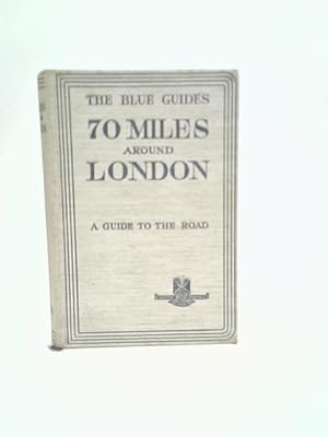
70 Miles Around London
Verlag: Macmillan & Co. Ltd, 1930
Anbieter: World of Rare Books, Goring-by-Sea, SXW, Vereinigtes Königreich
Bewertung:

Zustand: Good. 1930. No Edition Remarks. 30 pages. No dust jacket. White cloth board. Contains colour maps. Pages and binding are presentable with no major defects. Minor issues present such as mild cracking, inscriptions, inserts, light foxing, tanning and thumb marking. Overall a good condition item. Boards have mild shelf wear with light rubbing and corner bumping. Some light marking and sunning.
-
Hardcover. Zustand: Good. Hardcover. No DJ. Pages are clean and unmarked. Covers show edge wear with rubbing/light scuffing. Spine edge wear. Binding is tight, hinges strong. Previous owner's name on end paper.; 100% Satisfaction Guaranteed! Ships same or next business day!.
-
Hardcover. Zustand: Very Good. 2nd Edition. Early edtion from the esteemed Blue Guides series with complete atlas, as well as 54 original maps and plans.
-
Hardcover. Zustand: Very Good. 1st Edition. Early example of the Macmillan and Hachette Blue Guides series with gilt stamped covers, 32 maps and plans.
-
North-western France
Verlag: MacMillan/Librairie Hachette, London & Paris, 1932
Hardcover. Zustand: Very Good-. Zustand des Schutzumschlags: No Dust Jacket. Second Edition. Faint staining on cloth. ; With folded maps. ; The Blue Guides.
-
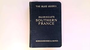
Southern France (Blue Guide)
Verlag: Macmillan and Co.
Anbieter: Goldstone Rare Books, Llandybie, CARMS, Vereinigtes Königreich
Bewertung:
Hardcover. Zustand: Good. First Edition. First edition. Photograph available on request.
-
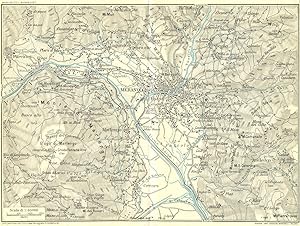
Zustand: Good. MERANO & ENVIRONS. Vintage map plan. Italy 1927 old vintage chart. Coloured vintage map; Muirhead, James, Findlay & Russell (Blue guides) (1927). 15.0 x 20.0cm, 5.75 x 7.75 inches; this is a folding map. Condition: Good. Tight right margin; The image shown may have been taken from a different example of this map than that which is offered for sale. The map you will receive is in good condition but there may be minor variations in the condition from that shown in the image. There is nothing printed on the reverse side, which is plain.
-
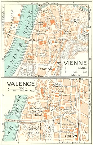
Zustand: Good. FRANCE. Vienne; Valence 1926 old vintage map plan chart. Coloured vintage map; Muirhead, James, Findlay & Russell (Blue guides) (1926). 14.0 x 8.5cm, 5.5 x 3.5 inches. Condition: Good. The image shown may have been taken from a different example of this map than that which is offered for sale. The map you will receive is in good condition but there may be minor variations in the condition from that shown in the image. There is nothing printed on the reverse side, which is plain.
-
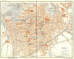
Zustand: Good. PROVENCE. Nimes 1926 old vintage map plan chart. Coloured vintage map; Muirhead, James, Findlay & Russell (Blue guides) (1926). 15.0 x 18.5cm, 5.75 x 7.25 inches; this is a folding map. Condition: Good. The image shown may have been taken from a different example of this map than that which is offered for sale. The map you will receive is in good condition but there may be minor variations in the condition from that shown in the image. There is nothing printed on the reverse side, which is plain.
-
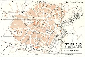
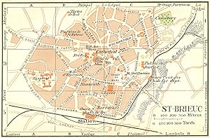
Zustand: Good. BRITTANY. Bretagne. St Brieuc 1928 old vintage map plan chart. Coloured vintage map; Drawn by L. Hermann, Delt (1928). 8.5 x 13.0cm, 3.25 x 5 inches. Condition: Good. The image shown may have been taken from a different example of this map than that which is offered for sale. The map you will receive is in good condition but there may be minor variations in the condition from that shown in the image. There is nothing printed on the reverse side, which is plain.
-
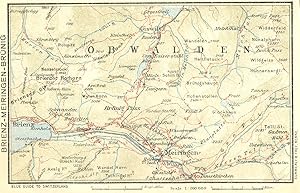
Zustand: Good. SWITZERLAND. Brienz-Meiringen-Brunig 1923 old antique vintage map plan chart. Coloured vintage map; Muirhead, James, Findlay & Russell (Blue guides) (1923). 9.0 x 14.5cm, 3.5 x 5.75 inches. Condition: Good. The image shown may have been taken from a different example of this map than that which is offered for sale. The map you will receive is in good condition but there may be minor variations in the condition from that shown in the image. There is nothing printed on the reverse side, which is plain.
-
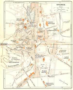
Zustand: Good. FRANCE. Hyeres 1926 old vintage map plan chart. Coloured vintage map; Muirhead, James, Findlay & Russell (Blue guides) (1926). 18.0 x 14.5cm, 7 x 5.75 inches; this is a folding map. Condition: Good. Minor offsetting -text and/or images from the facing page have left an impression on the print; The image shown may have been taken from a different example of this map than that which is offered for sale. The map you will receive is in good condition but there may be minor variations in the condition from that shown in the image. There is nothing printed on the reverse side, which is plain.
-
Zustand: Good. BRITTANY. St Brieuc 1932 old vintage map plan chart. Coloured vintage map; Muirhead, James, Findlay & Russell (Blue guides) (1932). 9.0 x 13.5cm, 3.5 x 5.25 inches. Condition: Good. The image shown may have been taken from a different example of this map than that which is offered for sale. The map you will receive is in good condition but there may be minor variations in the condition from that shown in the image. There is nothing printed on the reverse side, which is plain.
-
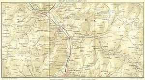
Zustand: Good. SWITZERLAND. Ragatz-Coire-Klosters 1923 old antique vintage map plan chart. Coloured vintage map; Muirhead, James, Findlay & Russell (Blue guides) (1923). 14.5 x 26.5cm, 5.75 x 10.5 inches; this is a folding map. Condition: Good. The image shown may have been taken from a different example of this map than that which is offered for sale. The map you will receive is in good condition but there may be minor variations in the condition from that shown in the image. There is nothing printed on the reverse side, which is plain.
-
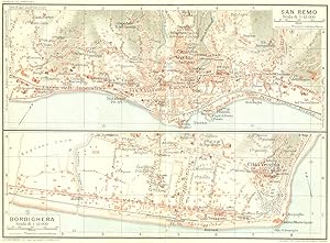
Zustand: Good. SAN REMO & BORDIGHERA. Vintage town city map plans. Italy 1927 old vintage. Coloured vintage map; Muirhead, James, Findlay & Russell (Blue guides) (1927). 14.5 x 20.0cm, 5.75 x 7.75 inches; this is a folding map. Condition: Good. The image shown may have been taken from a different example of this map than that which is offered for sale. The map you will receive is in good condition but there may be minor variations in the condition from that shown in the image. There are images and/or text printed on the reverse side of the picture. In some cases this may be visible on the picture itself or around the margin of the picture.
-
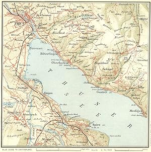
Zustand: Good. SWITZERLAND. Environs of Thun 1923 old antique vintage map plan chart. Coloured vintage map; Muirhead, James, Findlay & Russell (Blue guides) (1923). 14.5 x 14.0cm, 5.5 x 5.5 inches; this is a folding map. Condition: Good. The image shown may have been taken from a different example of this map than that which is offered for sale. The map you will receive is in good condition but there may be minor variations in the condition from that shown in the image. There is nothing printed on the reverse side, which is plain.
-
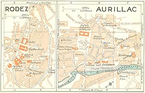
Zustand: Good. FRANCE. Rodez; Aurillac 1926 old vintage map plan chart. Coloured vintage map; Muirhead, James, Findlay & Russell (Blue guides) (1926). 8.5 x 14.0cm, 3.5 x 5.5 inches. Condition: Good. The image shown may have been taken from a different example of this map than that which is offered for sale. The map you will receive is in good condition but there may be minor variations in the condition from that shown in the image. There is nothing printed on the reverse side, which is plain.
-
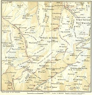
Zustand: Good. SWITZERLAND. Fionnay-Arolla 1923 old antique vintage map plan chart. Coloured vintage map; Muirhead, James, Findlay & Russell (Blue guides) (1923). 14.5 x 14.0cm, 5.75 x 5.5 inches; this is a folding map. Condition: Good. Tight top margin; The image shown may have been taken from a different example of this map than that which is offered for sale. The map you will receive is in good condition but there may be minor variations in the condition from that shown in the image. There is nothing printed on the reverse side, which is plain.
-
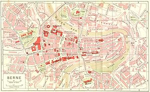
Zustand: Good. SWITZERLAND. Berne 1923 old antique vintage map plan chart. Coloured vintage map; Muirhead, James, Findlay & Russell (Blue guides) (1923). 13.5 x 22.5cm, 5.25 x 8.75 inches; this is a folding map. Condition: Good. The image shown may have been taken from a different example of this map than that which is offered for sale. The map you will receive is in good condition but there may be minor variations in the condition from that shown in the image. There is nothing printed on the reverse side, which is plain.
-
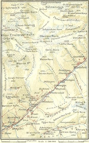
Zustand: Good. SWITZERLAND. Eggishorn-Munster 1923 old antique vintage map plan chart. Coloured vintage map; Muirhead, James, Findlay & Russell (Blue guides) (1923). 14.0 x 8.5cm, 5.5 x 3.5 inches. Condition: Good. The image shown may have been taken from a different example of this map than that which is offered for sale. The map you will receive is in good condition but there may be minor variations in the condition from that shown in the image. There is nothing printed on the reverse side, which is plain.
-
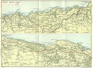
Zustand: Good. DEVON. North Coast 1924 old vintage map plan chart. Colour vintage map; John Bartholomew & Son (1924). 14.5 x 20.0cm, 5.75 x 7.75 inches; this is a folding map. Condition: Good. The image shown may have been taken from a different example of this map than that which is offered for sale. The map you will receive is in good condition but there may be minor variations in the condition from that shown in the image. There is nothing printed on the reverse side, which is plain.
-
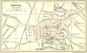
Zustand: Good. HEREFORD. Town Plan 1924 old vintage map chart. Colour vintage map; John Bartholomew & Son (1924). 8.5 x 14.5cm, 3.5 x 5.75 inches. Condition: Good. The image shown may have been taken from a different example of this map than that which is offered for sale. The map you will receive is in good condition but there may be minor variations in the condition from that shown in the image. There is nothing printed on the reverse side, which is plain.
-
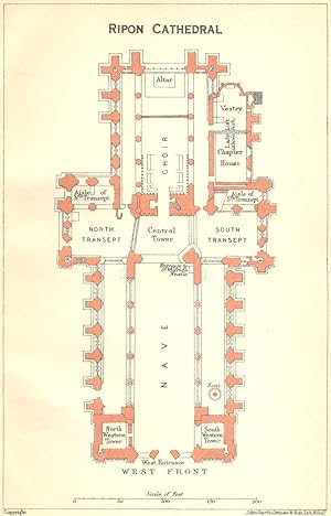
Zustand: Good. YORKS. Ripon cathedral 1924 old vintage map plan chart. Colour vintage map; John Bartholomew & Son (1924). 14.5 x 9.0cm, 5.5 x 3.5 inches. Condition: Good. The image shown may have been taken from a different example of this map than that which is offered for sale. The map you will receive is in good condition but there may be minor variations in the condition from that shown in the image. There is nothing printed on the reverse side, which is plain.
-
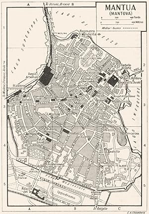
Zustand: Good. MANTUA town/city plan. Italy 1953 old vintage map chart. Vintage map; E.A. Chambers (1953). 13.0 x 9.0cm, 5 x 3.5 inches. Condition: Good. Verso text quite apparent; The image shown may have been taken from a different example of this map than that which is offered for sale. The map you will receive is in good condition but there may be minor variations in the condition from that shown in the image. There are images and/or text printed on the reverse side of the picture. In some cases this may be visible on the picture itself or around the margin of the picture.
-
Zustand: Good. PARMA town/city plan. Italy 1953 old vintage map chart. Vintage map; E.A. Chambers (1953). 9.0 x 13.0cm, 3.5 x 5 inches. Condition: Good. Verso text quite apparent; The image shown may have been taken from a different example of this map than that which is offered for sale. The map you will receive is in good condition but there may be minor variations in the condition from that shown in the image. There are images and/or text printed on the reverse side of the picture. In some cases this may be visible on the picture itself or around the margin of the picture.
-
Zustand: Good. NORTHANTS. Peterborough cathedral 1924 old vintage map plan chart. Colour vintage map; John Bartholomew & Son (1924). 14.5 x 9.5cm, 5.75 x 3.75 inches. Condition: Good. The image shown may have been taken from a different example of this map than that which is offered for sale. The map you will receive is in good condition but there may be minor variations in the condition from that shown in the image. There is nothing printed on the reverse side, which is plain.
-
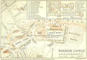
Zustand: Good. BERKS. Windsor Castle 1924 old vintage map plan chart. Colour vintage map; Emery Walker Ltd Sc (1924). 9.5 x 14.0cm, 3.75 x 5.5 inches. Condition: Good. The image shown may have been taken from a different example of this map than that which is offered for sale. The map you will receive is in good condition but there may be minor variations in the condition from that shown in the image. There is nothing printed on the reverse side, which is plain.
-
Zustand: Good. CREMONA town/city plan. Italy 1953 old vintage map chart. Vintage map; E.A. Chambers (1953). 9.0 x 12.5cm, 3.5 x 5 inches. Condition: Good. Verso text quite apparent; The image shown may have been taken from a different example of this map than that which is offered for sale. The map you will receive is in good condition but there may be minor variations in the condition from that shown in the image. There are images and/or text printed on the reverse side of the picture. In some cases this may be visible on the picture itself or around the margin of the picture.
-
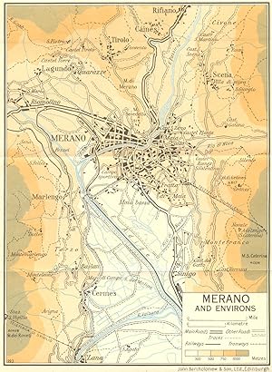
Zustand: Good. Merano and Environs 1953 old vintage map plan chart. Colour vintage map; John Bartholomew & Son (1953). 19.0 x 14.0cm, 7.5 x 5.5 inches; this is a folding map. Condition: Good. The image shown may have been taken from a different example of this map than that which is offered for sale. The map you will receive is in good condition but there may be minor variations in the condition from that shown in the image. There is nothing printed on the reverse side, which is plain.