
Gesamtpreis (1 Artikel Artikel):
Versandziel:

ORDINANCE SURVEY (34 Ergebnisse)
Direkt zu den wichtigsten Suchergebnissen
Produktart
- Alle Produktarten
- Bücher (28)
- Magazine & Zeitschriften
- Comics
- Noten
- Kunst, Grafik & Poster
- Fotografien
- Karten (6)
-
Manuskripte &
Papierantiquitäten
Zustand
Einband
Weitere Eigenschaften
- Erstausgabe (3)
- Signiert
- Schutzumschlag
- Angebotsfoto (11)
- Kein Print-on-Demand
Gratisversand
Land des Verkäufers
Verkäuferbewertung
-
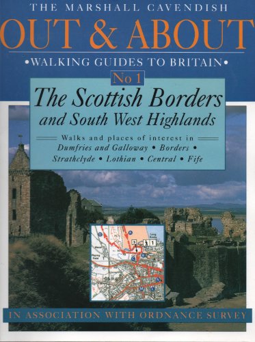
Scottish Borders and South West Highlands (Out & About Walking Guides to Great Britain)
Verlag: Ordnance Survey, 1995
ISBN 10: 0319005739ISBN 13: 9780319005736
Buch
Zustand: Very Good. 1688313393. 7/2/2023 3:56:33 PM.
Mehr Angebote von anderen Verkäufern bei AbeBooks
Neu ab EUR 97,76
Gebraucht ab EUR 3,19
Mehr entdecken Softcover
-

Darby and Burton Upon Trent (Sheet 120)
Verlag: Ordinance Survey, London, 1947
Anbieter: PsychoBabel & Skoob Books, Didcot, Oxfordshire, OXON, Vereinigtes Königreich
Bewertung:

paperback. Zustand: Good. Zustand des Schutzumschlags: No Dust Jacket. Cloth, New Popular edition, 1 inch map of England and Wales Size: 8vo - over 7ľ" - 9ľ" tall. Clean Copy.
-
Stradford on Avon and District (Sheet 82)
Verlag: Ordinance Survey, Southampton, 1919
Anbieter: PsychoBabel & Skoob Books, Didcot, Oxfordshire, OXON, Vereinigtes Königreich
Bewertung:
paperback. Zustand: Good. Zustand des Schutzumschlags: No dust jacket. Cloth, Popular Edition, 1 inch to 1 mile, Contoured Road Map Size: 8vo - over 7ľ" - 9ľ" tall. Used.
-
Weymouth, Yeovil and Taunton (Sheet 37)
Verlag: Ordinance Survey, Southampton, 1929
Anbieter: PsychoBabel & Skoob Books, Didcot, Oxfordshire, OXON, Vereinigtes Königreich
Bewertung:
paperback. Zustand: Good. Zustand des Schutzumschlags: No dust jacket. Cloth, Popular Edition, 1/2 inch to 1 mile, Contoured Road Map Size: 8vo - over 7ľ" - 9ľ" tall. Used.
-
Ordinance Survey: Abingdon, Wantage & Vale of White Horse Explorer 170
Verlag: Ordinance Survey NULL
Zustand: Fair. This is an ex-library book and may have the usual library/used-book markings inside.This book has hardback covers. With usual stamps and markings, In fair condition, suitable as a study copy. No dust jacket. Inside a hardcover. Please note the Image in this listing is a stock photo and may not match the covers of the actual item,350grams, ISBN:
-
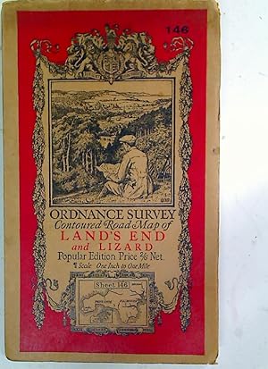
Land's End and Lizard.
Verlag: Southampton: Ordnance Survey, 1930
Buch
Map. Zustand: Good. 1p large fold out map, mounted on linen, illustrated card cover, well folded map in good clean condition Language: English.
-
Galway Offaly Ordnance Survey Map 1976 Color Fold Out
Verlag: Ordinance Survey Of Ireland, Ireland, 1976
Anbieter: Three Geese in Flight Celtic Books, Los Angeles, CA, USA
Bewertung:
Erstausgabe
Paperback. Zustand: Fine. 1st Edition. Ireland: Ordinance Survey Of Ireland, 1976. Book. Fine. Card Wrappers. 1st Edition. Handsome Color Fold Out Color Map Of County Galway/Offaly Card Stock covers Fine Clean Condition NOT a library copy.
-

SITTINGBOURNE-FAVERSHAM (Explorer Maps)
Verlag: Ordnance Survey, 1997
ISBN 10: 0319217604ISBN 13: 9780319217603
Buch
Zustand: New. Buy with confidence! Book is in new, never-used condition.
-
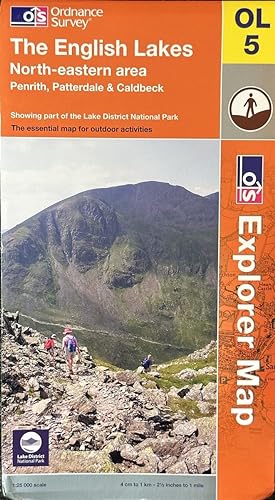
The English Lakes - North-Eastern Area - Penrith, Patterdale & Caldbeck
Verlag: Ordnance Survey, 2008
ISBN 10: 0319240223ISBN 13: 9780319240229
Anbieter: Dr.Bookman - Books Packaged in Cardboard, Pittsburgh, PA, USA
Bewertung:
Karte
Map. Zustand: Near Fine. This specific map is in very good condition with some minor wear to the cover or edges and corners but with clean, untorn folds. The map is clean, crisp, unmarked and unwrinkled. We package all maps in custom cardboard book boxes for shipment and ship daily with tracking numbers.; This map is produced by Ordinace Survey. Specifically, it is The English Lakes, North-eastern area, Penrith, Patterdale & Caldbeck. The map is numbered OL5 and is a 1:25,000 scale where 4 cm to 1 km or 2 1/2 inches to one mile. ; Explorer Map Series; Large 8vo 9" - 10" tall; 1 pages.
-
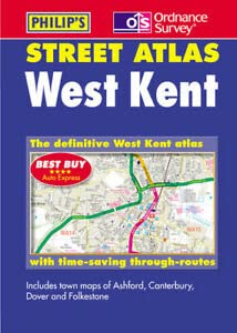
West Kent Street Atlas (Pocket Street Atlas)
Verlag: Philip's, London, UK., 2003
ISBN 10: 0540079820ISBN 13: 9780540079827
Anbieter: J J Basset Books, bassettbooks, bookfarm.co.uk, Peter Tavy, Vereinigtes Königreich
Bewertung:

Buch
Glossy Pictorial Card. Zustand: Near Fine (NEAR NEW). No Jacket. Street Maps (illustrator). This is the first edition of this edition. POSTED AT OUR STANDARD RATES FULLY INSURED! (UK ONLY). FEEL FREE TO E-MAIL FOR PHOTOGRAPHS AND FURTHER DETAILS. FROM A DEALER WHO TELLS YOU WHO THEY ARE AND WHAT THEIR TELEPHONE AND ADDRESS CONTACT DETAILS ARE! Size: 12mo - over 6ľ" - 7ľ". Not Signed or Inscribed. Mass Market Paperback.
-
Pathfinder Maps: Tal-y-Bont and Ponterwyd Sheet 927 (SN68/78)
Verlag: Ordinance Survey, 1987
ISBN 10: 031920927XISBN 13: 9780319209271
Buch
Paperback. Zustand: Good. good copy with one small closed tear.
-
Soft cover. Zustand: Good. Good used condition, circa 1920's, linen backed, folded, pencil notes on the back of map, light age discolouration marks, light wear & marks.
-
Survey of Ireland (Ordinance Survey) Kerry - Limerick: Sheet 152
Verlag: Ordinance Survey Office, Southampton, England, 1905
Karte
Map. Zustand: Very Good. Zustand des Schutzumschlags: No Dust Jacket. Fold-out map in card covers. Covers are 7-1/4" x 3-3/4". Map is approximately 14" x 21". Corners of covers are lightly bumped. Covers are clean, but a bit curved - probably from being carried in a back pocket. ; 23D.
-
Survey Of Ireland (Ordinance Survey) Limerick: Sheet 153
Verlag: Ordinance Survey Office, Southampton, England, 1906
Karte
Map. Zustand: Very Good. Zustand des Schutzumschlags: No Dust Jacket. Fold-out map with card covers. Cover is 7" x 3-3/4". Map is approximately 14" x 18". Scale: 1" to a mile. The rear cover has a diagram of the various sheets. A couple corners of the covers are lightly bumped. The rear cover is slightly faded. ; 23D.
-
Survey Of Ireland (ordinance Survey) Limerick - Tipperary: Sheet 164
Verlag: Ordinance Survey Office, Southampton, England, 1902
Karte
Map. Zustand: Very Good. Zustand des Schutzumschlags: No Dust Jacket. Fold-out map in card covers. Covers are 7-1/4" x 3-3/4". Map is 14" x 21". Scale: 1 inch to a mile. Map has two 1" tears to the outer corners of the center fold. Small smudge on rear pastedown. Cos. Cork & Limerick. ; 23D.
-
Hardcover. Zustand: Good+. B/w Map (illustrator). Second Edition. Canvas backed folding map (28" x 42"); bound in cloth-backed boards; wear and rubbing to cloth at spine; some soiling to boards; marbled endpapers; foxing and browning to map at creases; owner's name in ink. Size: 8vo - over 7ľ" - 9ľ" tall. Book.
-
Zustand: Very Good +. Very good, linen backed folding map with a little wear to extremities of card covers. map has no tears. Half inch series. Size: 12 Inches By 29 Inches.
-
Hardcover. Zustand: Used: Acceptable. Condition good, includes the 2 maps. Inscription inside cover. ref ZKVQ.
-

Ordinance Survey 'One Inch' Map of Land's End and Lizard (5th edition)
Verlag: Ordinance Survey, 1936, 1936
Soft cover. Zustand: Near Fine. folded map in card covers some slight edgewear to covers and one small chip at lower front corner otherwise a seemingly unused copy excellent clean tight bright and unmarked.
-
Ordinance Survey Ancient Britain North Sheet A Map of the Visible Antiquities of Great Britain Older Then A.D.1066 North Sheet
Verlag: Ordinance Survey, England, 1964
Anbieter: Three Geese in Flight Celtic Books, Los Angeles, CA, USA
Bewertung:
Paperback. Zustand: Near Very Good. Second Edition. England: Ordinance Survey, 1964. Book. Near Very Good,tight. Paperback. Second Edition. 8vo - over 7Ă Âľ" - 9Ă Âľ" tall. Trade Paperback and Large Fold Out Color Map. Stiff Wrap Around Card Covers. Near Very Good. Second Edition. Great for the tour guide to sacred sites of Britain or the armchair guide of Celtic and Megalithic Britain. Opens huge! North sheet.
-
Cloth-backed coloured folding map of Egri Palanka (Macedonia). Scale 1 : 200,000.
Erscheinungsdatum: 1916
Anbieter: Anthony C. Hall, Bookseller ABA ILAB, Isleworth, MIDDX, Vereinigtes Königreich
Verbandsmitglied: ABA ILAB PBFA
Bewertung:
Paperback. Measuring 70 X 55 cm. Very slightly marked copy with the stamp of the 707th M.T. Company of the Army Service Corps.
-
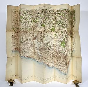
England and Wales Ordnance Survey (Large Sheet Series): Sheet 137 (Brighton, Eastbourne and Lewes)
Verlag: Director General at the Ordnance Survey Office, Southampton, 1912
Anbieter: Minotavros Books, ABAC ILAB, Whitby, ON, Kanada
Bewertung:
No Binding. Zustand: Very Good. Folding paper-on-linen colour map. 4.5" x 6.5" folded. 1 inch to a mile scale. Some staining, small perforations at folds, light fraying to edges. Pencil owner inscription to head of front when folded.
-
Ordinance Map of New Park, Bucklandburgh, South Devon
Verlag: Southampton: Director General at the Ordinance Survey Office, 1905
Second Edition. Near fine copy in the original stiff-card wrappers; edges very slightly dust-dulled and toned. Remains particularly and surprisingly well-preserved; tight, bright, clean and especially sharp-cornered. Physical description; 1 map. Subjects; New Park. Bucklandburgh. South Devon. 20th century maps. 1 Kg.
-
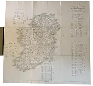
Charts Showing Positions of Lighthouses, Fog Signals and Other Sea Marks, under the Jurisdiction of the Commissioners of Irish Lights. The Lighthouses and Fog Signals with their characteristics are marked in their respective positions on the Chart. The positions of the Minor Lights and Sea Marks indicated by numbers on the Chart and are described in the Table on the margin. Reduced from the four mile maps. Scale 10 miles to 1 inch. (With Sea Mark tables by region, on the margins)
Verlag: Dublin. Published by Director-General of the Ordinance Survey Office. 1925, 1925
Anbieter: J. Patrick McGahern Books Inc. (ABAC), Ottawa, ON, Kanada
Verbandsmitglied: ABAC ILAB IOBA
Bewertung:
Hardcover. Zustand: Fine. linen backed colour folding map, 102 (40")x 105.5 (41.5"), folded to 34x 36cm, in dark green contemporary full buchram, light green finished cloth endpapers with gilt title on the upper cover, fine (Ho5B) ~ First published in 1905, reprinted in 1925, but indicating 1926 on the cover title. No standard references located.
-
of Great Britain [England and Wales and Southern Scotland*]. Scale 10 statute miles to one inch.
Verlag: Southhampton ., 1902
Anbieter: Robert Frew Ltd. ABA ILAB, London, Vereinigtes Königreich
Verbandsmitglied: ABA ILAB PBFA
Bewertung:
Karte
Large lithographed map (overall 141 x 110 cm) with colour wash to coastline, dissected into 12 panels laid on linen and folding into original maroon cloth covers (48 x 28 cm.) , marbled endpapers, paper label "England" to upper board, Stanford label to lower margin of the map. Some staining to outer covers, contents clean and fresh *Includes Scotland south of Inverness.
-
First Edition. Near fine folding map with the original canvas backing and buckram, paper labeled slip-case. Remains well preserved overall; bright, tight, clean and sharp-cornered. Physical description; 1 folding map. Subjects; Glouscestershire. Folding maps. English maps. 19th century maps. 1 Kg.
-

First Edition. Near fine folding map with the original canvas backing and buckram, paper labeled slip-case. Remains well preserved overall; bright, tight, clean and sharp-cornered. Physical description; 1 folding map. Subjects; Glouscestershire. Folding maps. English maps. 19th century maps. 1 Kg.

![Bild des Verkäufers für of Great Britain [England and Wales and Southern Scotland*]. Scale 10 statute miles to one inch. zum Verkauf von Robert Frew Ltd. ABA ILAB](https://pictures.abebooks.com/inventory/md/md30291671466.jpg)