Gesamtpreis (1 Artikel Artikel):
Versandziel:

PAOLO FORLANI (31 Ergebnisse)
Direkt zu den wichtigsten Suchergebnissen
Produktart
- Alle Produktarten
- Bücher (10)
- Magazine & Zeitschriften
- Comics
- Noten
- Kunst, Grafik & Poster (9)
- Fotografien
- Karten (12)
-
Manuskripte &
Papierantiquitäten
Zustand
Einband
Weitere Eigenschaften
- Erstausgabe (2)
- Signiert
- Schutzumschlag
- Angebotsfoto (27)
- Kein Print-on-Demand
Land des Verkäufers
Verkäuferbewertung
-

Pallina [Hardcover] Renato Prinz; Paolo Albiicocco (illustrator); Giorgio Forlani (illustrator)
Verlag: Ugo Mursia Editore
Buch
hardcover. Zustand: Very Good. Italy, 1963; Italian text; cloth covered boards; no dust jacket; slight bumping at corners of cover; minor shelf wear at edges of back strip; some rubbing; some soiling/smudging on boards; Interior clean and unmarked; 4to, 9 3/4" - 12" Tall; 33 pages.
-
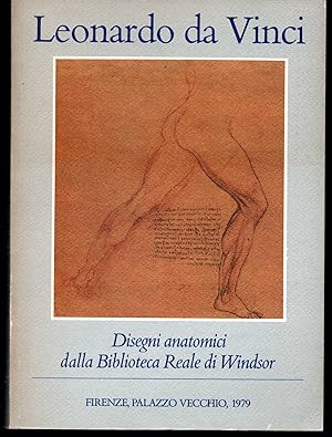
Leonardo da Vinci Disegni anatomici dalla Biblioteca Reale di Windsor Firenze, Palazzo Vecchio, maggio/settembre 1979
Verlag: Giunti Barbera, Firenze, 1979
Storia e Critica Dal Rinascimento al Neoclassicismo Fine arts History and Criticism From Renaissance to Neoclassicism bross. edit. ill., pp. 160, minima brunitura in cop., firma di appartenenza illustrazioni in b.n. e colori nel testo fuori catalogo.
-
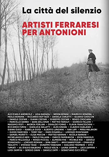
La cittŕ del silenzio. Artisti ferraresi per Antonioni. Nuova ediz.
Verlag: Fondazione Ferrara Arte, 2022
ISBN 10: 8889793686ISBN 13: 9788889793688
Buch
Zustand: NEW.
-
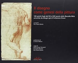
leg.ed.soprac.fig.a colori. Zustand: COME NUOVO. Prefazione di Sir Denis Mahon. A cura di Pier Paolo Quieto. Una raffinatissima selezione di opere grafiche di altissimo rilievo, cronologicamente inquadrata tra il Cinquecento e l'Ottocento permette di affrontare la complessa tematica del processo ideativo del fare artistico. Dagli schizzi dei Carracci e di maestri del Barocco come Carlo Maratti e Pierfrancesco Mola, di autori dal vezzoso tratto settecentesco come Fragonard e Batoni, e dai bozzetti della grande firma neoclassica di David e poi dei puristi Minardi e Bezzuoli per arrivare ai progetti macchiaioli del Cabianca, Pierpaolo Quieto guida il lettore proponendo numerosi confronti con le opere finite di cui i disegni presentati rappresentano la prima idea. Con saggi di Sir Dennis Mahon e Anna Forlani Tempesti. cm.30x24,5, formato albo. pp.284, centinaia di figg.a col.nt. Firenze, Edifir cm.30x24,5, formato albo. pp.284, centinaia di figg.a col.nt. leg.ed.soprac.fig.a colori.
-

26,5 x 21 cm. 8 unnum. Blatt mit farbigen Illustrationen. OBroschur. - Papierbedingt etwas gebräunt, innen meist sauber.
-
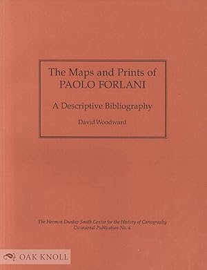
MAPS AND PRINTS OF PAOLO FORLANI.|THE
Verlag: The Newberry Library, Chicago, 1990
Anbieter: Oak Knoll Books, ABAA, ILAB, NEW CASTLE, DE, USA
Bewertung:

stiff paper wrappers. Forlani, Paolo (illustrator). 4to. stiff paper wrappers. (xiii), 21 plates, 60 pages. The Hermon Dunlap Smith Center for the History of Cartography Occasional Publication No. 4. This volume is a descriptive bibliography of the map maker Paolo Forlani, who was active in sixteenth-century Italy. It includes 144 items with 21 black-and-white illustrations, a list of references, an index of persons named and a geographical index. Minor soiling on covers with some dents on covers and wear and small closed tears all over spine.
-
Il Gerbi
Verlag: Venezia, 1569
Anbieter: Libreria Ex Libris ALAI-ILAB/LILA member, Roma, Italien
Bewertung:
Karte
Incisione originale su rame (cm. 28x19 piů ampi margini). Ottimo esemplare. Rara.
-
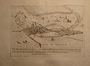
(Sito e forma di Ginevra)
Verlag: Venezia, 1569
Anbieter: Libreria Ex Libris ALAI-ILAB/LILA member, Roma, Italien
Bewertung:
Karte
Acquaforte originale (cm. 25,5x18 piů ampi margini bianchi) tratta dalla celebre opera 'De' disegni delle piů illustri cittŕ et fortezze del mondo.' di Giulio Ballino. Ottimo stato di conservazione. Rara.
-
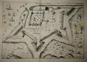
Disegno vero della Cittŕ et fortezza di Fano nella Marca d'Ancona
Verlag: Venezia, 1569
Anbieter: Libreria Ex Libris ALAI-ILAB/LILA member, Roma, Italien
Bewertung:
Karte
Incisione originale su rame (cm. 28,7x20,5 piů ampi margini). Due fori di tarlo restaurati altrimenti buon esemplare. Rara.
-
Il vero disegno e ritrato di Parma Cittŕ Nobilissima, et Illustrissima, in Lombardia, si come veramente hoggi di si trova, nell'anno del Signore MDLXVII.
Erscheinungsdatum: 1567
Anbieter: BOTTEGHINA D'ARTE GALLERIA KÚPROS, Rosignano Solvay, LI, Italien
Bewertung:
Kunst / Grafik / Poster
No legatura. Zustand: ottimo. Venezia, 1567. Incisione in rame (eseguito al bulino con ritocchi occasionali all acquaforte), cm 18 x 25,5 (alla lastra), cm 27,2 x 41,3 (il foglio). In lastra: titolo in alto al centro; in basso la dicitura: "Il vero disegno e ritrato di Parma Cittŕ nobilissima, et illustrissima, in Lombardia, si come veramente oggi di si trova, nell'anno del signore MDLXVII". Testo in volgare al verso. Per la prima volta pubblicata nella rara raccolta di Paolo Forlani "Il primo libro delle cittŕ et fortezze principali del mondo", edito nel 1567 a Venezia, questa lastra proviene dalla successiva (di due anni) raccolta del Ballino "De' Disegni delle piů belle illustri cittŕ e fortezze del Mondo.", stampato a Venezia da Bolognino Zaltieri nel 1569. L opera, costituita da cinquanta vedute e da una carta geografica, rappresenta il primo tentativo, nell ambito dell editoria italiana, della realizzazione di un testo / atlante delle principali fortezze e cittŕ del mondo. A differenza dei suoi predecessori, dei quali utilizza spesso i rami e le iconografie, il Ballino concepisce un opera unitaria corredata di testi e di indice, della quale, per la prima volta, si č ha conoscenza dell esatto numero di tavole che la compongono. Le carte della raccolta sono datate tra il 1566 ed il 1568 e trentadue di queste risultano essere ristampe dei rami di Paolo Forlani e di Domenico Zenoi, per la prima volta apparsi ne "Il primo libro delle cittŕ, et fortezze principali del mondo" del Forlani (edito nel 1567); questo cospicuo gruppo di tavole č inserito nella raccolta con alcuni ritocchi nelle lastre, che vengono modificate. Altre furono per la prima volta pubblicate da Ferrando Bertelli nel "Disegni di alcune piů illustri cittŕ di fortezze del mondo con aggiunte di alcune isole principali" (edito nel 1568). Il resto delle tavole sono di anonimi incisori di cui l autore si servě per la sua opera, probabilmente anche per ritoccare le lastre di cui era giŕ in possesso. Per correttezza di informazione la paternitŕ delle opere, sebbene provenienti dalla raccolta del Ballino, viene assegnata all autore originale. Paolo Forlani (o Furlani) fu attivo a Venezia tra il 1560 e il 1574 come mercante di stampe e incisioni, in particolare di carte geografiche, vedute e piante. Le sue incisioni, in gran parte di soggetto geografico, risultano pubblicate dai principali editori e stampatori veneziani. Importante per il Forlani č la collaborazione con Giacomo Gastaldi, e anche quella con Claudio Duchetti. Giulio Ballino era un avvocato veneziano che frequentava la casa dei Manuzio giŕ verso il 1530, dedicandosi in gioventů allo studio dei classici. Rara. Ottima impressione stampata, con bella e fresca inchiostrazione, su carta vergellata greve. In ampi margini e in bella impressione, ottima conservazione. .
-

Il vero disegno della pianta di Milano si come veramente ogi dě si ritrova
Verlag: Venezia, 1569
Anbieter: Libreria Ex Libris ALAI-ILAB/LILA member, Roma, Italien
Bewertung:
Karte
Incisione originale su rame (cm. 28,7x20,5 piů ampi margini). Ottimo esemplare. Rara.
-
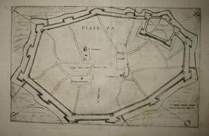
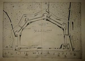
Piaseza
Verlag: Venezia, 1569
Anbieter: Libreria Ex Libris ALAI-ILAB/LILA member, Roma, Italien
Bewertung:
Karte
Incisione originale su rame (cm. 28x18 piů ampi margini). Ottimo esemplare. Rara.
-
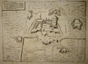
Mirandola
Verlag: Venezia, 1569
Anbieter: Libreria Ex Libris ALAI-ILAB/LILA member, Roma, Italien
Bewertung:
Karte
Incisione originale su rame (cm. 26x19,5 piů ampi margini). Lievi fioriture altrimenti ottimo esemplare. Rara.
-
Parise
Verlag: Venezia, 1569
Anbieter: Libreria Ex Libris ALAI-ILAB/LILA member, Roma, Italien
Bewertung:
Karte
Acquaforte originale (cm. 25,5x18,5 piů ampi margini bianchi) tratta dalla celebre opera 'De' disegni delle piů illustri cittŕ et fortezze del mondo.' di Giulio Ballino. Ottimo stato di conservazione. Rara.
-
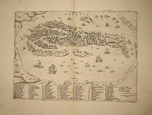
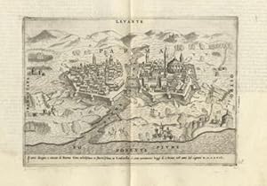
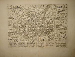
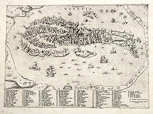
Venetia
Verlag: Venezia, 1569
Anbieter: Libreria Ex Libris ALAI-ILAB/LILA member, Roma, Italien
Bewertung:
Karte
Incisione originale su rame (cm. 27x19,5 piů ampi margini bianchi). Testo in italiano al verso. Esemplare in nitida impressione ed in eccellente stato di conservazione. Interessante e rara pianta prospettica della cittŕ di Venezia proveniente dall'opera 'De' disegni delle piů illustri cittŕ, et fortezze del mondo' di Giulio Ballino.
-
Venetia
Verlag: Venezia, 1567
Anbieter: libreria antiquaria perini Sas di Perini, Verona, VR, Italien
Bewertung:
Kunst / Grafik / Poster
Incisione in rame, mm 190x265. Rarissima veduta tratta da ěIl primo libro delle citta, et fortezze principali del mondoî, edito nel 1567, le cui lastre furono riutilizzate da Giulio Ballino nel 1569 con líaggiunta di testo al verso per la sua opera ěDeí disegni delle pi? illustri citt? et fortezze del mondoî edito da Bolognino Zaltieri. Paolo Forlani veronese fu attivo a Venezia tra il 1560 e il 1574 come incisore e mercante. Le sue incisioni, in gran parte di soggetto geografico, furono pubblicate dai principali editori e stampatori veneziani. Egli collaborÚ spesso con Gastaldi del quale incise ben 13 carte. La sua opera pi? importante Ë la raccolta ěIl primo delle citt?, et fortezze principali del mondoî, prima organica collezione di cartografia urbana stampata in Italia, con incisioni datate 1566 e 1567. Forlani non pubblicÚ mai la seconda parte e consegnÚ i rami a Zenoi che nello stesso anno li riutilizzÚ in una sua raccolta senza titolo. Dopo il 1574 si perdono sue notizie. Molto probabilmente morĎ durante la grande peste che colpĎ Venezia tra il 1575 ed il 1576. Bellíesemplare con buoni margini. Manca a Moretto ěVenetia, le immagini della Repubblicaî e Cassini ěPiante e vedute prospettiche di Veneziaî. Nr.cat: P7160810.
-
![Bild des Verkäufers für Nuova, et coppiosa, descritttone [sic] di tutto l'Egitto. zum Verkauf von Arader Galleries - AraderNYC](https://pictures.abebooks.com/inventory/md/md30303307731.jpg)
Engraved map of Egypt (10 Ľ x 13 Ľ in.; 26 x 33.7 cm) with latitudinal and longitudinal lines along margins, showing topography, vegetation, waterways, ports, and pictorial vignettes of settlements. BINDING/CONDITION: Some faint discoloration along centerfold crease. Loosely laid on sturdy card and enclosed in mylar. (65B3E) THE FIRST MODERN MAP OF EGYPT, upon which Abraham Ortelius based his atlas map "Aegypti recentior descriptio." PROVENANCE: Reiss & Sohn (sale, 13 November 2018, lot 2462) REFERENCES: Bifolco & Ronca, "Cartografia e topografia italiana del XVI secolo," I, p. 462,no. 106; Tooley, 193; cf. Van den Broecke, "Ortelius Atlas Maps. An Illustrated Guide" (2d ed.), 174b, pp. 518-519.
-

No Binding. Zustand: Very Good. Fascinating 1566 Lafreri bird s-eye-view of Tunis with the ruins of Carthage. Bird s-eye-view of Tunis, the most important Ottoman naval base of the western Mediterranean. First state (according to Woodward), actually the second state with the addition of the name of Zaltieri. Rare geographical map depicting the city of Tunis with ancient Goletta and the northern coasts of North Africa, with the ruins of Carthage. States & editions: 1st: No Zaltieri or date; 2nd: as described, Bolognini Zalterii Anno. M.D.LXVI; 3rd: addition of Io. Orlandi formis romae 1602. The map has no title, but it bears an extensive explanatory text, with the date and signature of the author: Benigni Lettori, per rappresentarui piu particulari della Cittŕ di / Tunesi, holla tenuta alquanto piu larga di quello che importa la / pianta di essa Cittŕ secondo la mesura, ň scala delli miglia, laquale / solamente ui seruirŕ ŕ sapere le distantie da un luogho all altro: / Piu altra i monti che sono alla sinestra dello stagno per la loro asprez= / za no[n] si possono cultiuare, le Colline alla destra sono tutti fruttifere, / lo stagno non č nauigabile se no[n] per lo canale. La Torre appresso la Go= / letta č per la difesa de pozzi da quali si ha l acqua per uso della Cittŕ: / Le Mura che abbracciano i borghi sono di altezza di tre braccia, / et debolossime, et solo fatte per reparar all improuiso assalto de gli / Arabi; Bardo, Mescia, et Restabia sono serragli del Re: jl Borgo / Rabat č habitato da Soldati Christiani: jl Borgo Nifet da gli Arabi: / jl Mercator del bestiame si fa nella piazza appresso la Meschita: / La Piazza de Christiani č alli Magazeni: il porto appresso le ruine / di Cartagine č quasi ripieno, et no si usa piu: / Venetijs ex ćneis formis Bolognini Zalterij / Anno . M . D . LXVI . Oriented with the south at the top, the map depicts military camps and naval battles, scenes that are however only imaginary; at the time, in fact, there were no conflicts around Tunis. It is a fairly faithful copy of a Roman engraving by Agostino de Musi, known as Agostino Veneziano, published to illustrate the 1535 conquest of Tunis by the Christian fleet under the command of Charles V. In making the copy, Forlani made a mistake by omitting the scale of the miles despite mentioning it in the explanatory text.
-
Descrittione del Ducato di Savoia Novamente posto Novamente posto in luce in Venetia L'anno M.DC
Verlag: Venezia, 1562
Anbieter: libreria antiquaria perini Sas di Perini, Verona, VR, Italien
Bewertung:
Kunst / Grafik / Poster
Copper engraving, mm 320x435. Rarissimo terzo stato di una pietra miliare della cartografia della Savoia, a lungo considerata la prima carta a stampa della regione, finchË nel 1903 non si scoprĎ un esemplare della rarissima carta di Gilles Boileau de Buillon del 1556. Forlani copia questa carta operando piccole variazioni alla toponomastica. Il primo stato viene pubblicato nel 1562, poi la lastra viene stampata da Bertelli che aggiunge la nota "Ferando Bertelli Libraro exc"; il nostro esemplare presenta la nota "Donato Rasciotti forma" mentre la precedente Ë cancellata; la data diventa MDC. Esiste poi un ulteriore quarto stato in cui viene abrasa la firma di Rasciotti sostituita da "F. Valeggio forma" Ottimo esemplare a pieni margini originali. Aliprandi, Le grandi alpi nella cartografia, vol 1, pag 163; lago, Imago Mundi et Italiae, pag 250; Meurer, Strabo illustratus atlas, n. 69; Woodward, Paolo Forlani, n. 17; Bifolco-Ronca, Cartografia rara italiana: XVI secolo, n. 42; Valerio, L'Italia e le sue regioni, pag. 32-33 Nr.cat: Cod 3479.
-

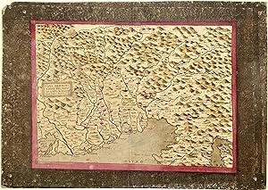
Nova Discritttione dela Dalmatia, et Crovatia, M.D.LXV
Verlag: Bertelli, Venice, 1565
Anbieter: libreria antiquaria perini Sas di Perini, Verona, VR, Italien
Bewertung:
Kunst / Grafik / Poster
Copper engraving, mm 275x390, signed "Ferando Bertelli exc in Venetia" in bottom left cartouche under the title. Bertelli publishes this map two years after the first by Camocio basing his map on Gastaldi's model. It's in effect a reprint of Camocio's one, attributed by Woodward to Forlani, as engraver. First state of the map, out of two: the second state bears the date 1616 and is signed by Valegio. Very good full margin copy with some reinforcements on verso. Meurer (2002): n. 42; Nordenski?ld (1981): n. 37; Shirley (2004): I, n. 106; Bifolco-Ronca (2014): n. 74; Cartografia Rara (1986): n. 37; Lago-Rossit (1981): tav. XXV; Lago (1994): p. 342, fig. 29 e p. 346, fig. 33; Lago (1998): n. 98 & 99; Woodward (1990): n. 40 Nr.cat: Cod 3480.
-
(Il Veronese)
Verlag: Venezia, 1574
Anbieter: libreria antiquaria perini Sas di Perini, Verona, VR, Italien
Bewertung:
Kunst / Grafik / Poster
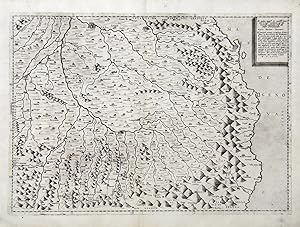
Acquaforte e bulino, mm 515x350. Impressa su carta vergata. Stato VII/VIII conosciuto solo in un'altra copia alla Newberry Library di Chicago. La PRIMA CARTA a stampa del territorio di Verona, dedicata al conte Nicola Rambaldo. Carta corografica del territorio veronese eseguita da Paolo Forlani veronese, editore ed incisore attivo a Venezia, che si sottoscrive nella dedica, derivata da un modello di Bernardino Brugnoli a cui attinse poi anche Abraham Ortelius per la carta del veronese del 1578 inserita nel suo celebre atlante "Theatrum Orbis Terrarum". Forlani nella dedica spiega i motivi che lo spinsero a realizzare la sua pubblicazione: "Dopo ch'io faccio questo esercizio di intagliar stampe ho sentito pi? volte moltiÖdolersi che una cosa si bella et rara, quale Ë il territorio veronese, non sia stato comunicata al mondo per via di una stampa. Il che per certo mi accendeva di desiderio di pormi una volta con ogni studio a questa impresa. PerÚ essendomi stata fatta gratia di questa forma assai comoda d'esso territorio descritta co' propri nomi fedelmente et diligentemente da M. Bernardin Brognolo perito de' Beni IncultiÖho voluto soddisfacendo al desiderio et debito mioÖvedere questo bellissimo territorio intagliato in rame e stampato" Brugnoli o Brugnolo fu architetto e perito dei Beni Inculti, prima di passare nel 1580 al servizio dei Gonzaga; si rese autore di una serie di accurati rilievi del Veronese basandosi per la parte occidentale sulla carta del Bresciano di Cristoforo Sorte, mentre per il resto del territorio presumibilmente si servĎ di documenti manoscritti, che aveva potuto esaminare grazie alla sua carica. Della carta esistono ben 8 differenti stati a partire dalla prima stesura del 25 ottobre 1574; fu poi stampata con modifiche di data e di indirizzi editoriali da Pinargenti (stato II), Andrea Bertelli (III), Valegio (IV), con data 1596 (V), con data 1612 (VI), Scolari 1612 (VII) e Lovisa con data 1700 (VIII). Bell'esemplare marginoso con tracce di sporco ed una piccola escoriazione alla piega centrale.Almagi? (1929), p. 37-38; Tooley (1939), 593; Woodward (1990), 97; Lago (1994), p. 261; Meurer (1991), p. 120-121; Perini (1996), p. 72-73; Bifolco-Ronca, Cartografia e topografia italiana del XVI secolo, 967. Nr.cat: 8034.
-
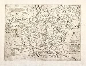
Nova Descrittione del Friuli Anno M.D.LXIV
Verlag: Venezia, 1563
Anbieter: libreria antiquaria perini Sas di Perini, Verona, VR, Italien
Bewertung:
Kunst / Grafik / Poster
Acquaforte e bulino, mm 270x380, impressa su carta vergata, in antica coloritura, montata su supporto cartonato presumibilmente settecentesco, con qualche difetto del tempo e piccole mancanze agli spigoli ed angoli, inclusi quattro fori agli angoli, evidentemente eseguiti per esporre la carta senza cornice anticamente. Stato II/III con la data cambiata dal 1563 a 1564 prima dell'aggiunta della citt? appena fondata nel 1593 di Palmanova, visibile nel terzo stato di NicolÚ Valegio. Il titolo Ë riportato entro cartiglio quadrato a sinistra, dove Ë riportata anche la firma dell'autore "Paulo Forlano veronese f"; la carta Ë priva di scala grafica e margine graduato ed Ë orientata in modo tradizionale col nord-Tramontana in alto. Questa carta di Forlani Ë una derivazione di Vavassore del 1550 ma attinge anche al modello precedente del 1561, anonima anche se attribuita da Woodward allo stesso Forlani e poi pubblicata da Camocio col suo indirizzo. La carta ebbe enorme successo commerciale e molti esemplari sono noti in raccolte pubbliche.Almagi? (1927) p. 88; Cartografia rara (1986), 51; Lago-Rossit (1981), p. 56-57; Perini (1996), p. 85; Tooley (1983), 127b; Woodward (1990), 31; Bifolco-Ronca, Cartografia e topografia italiana del XVI secolo, tav. 977 Nr.cat: 8040.
-
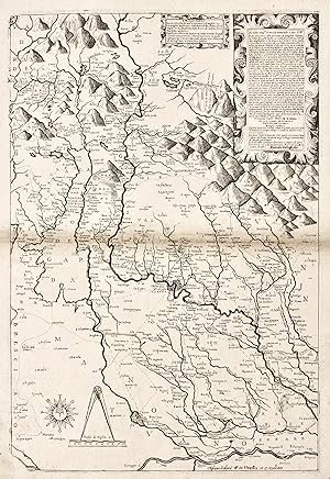
La descrittione del PiamonteÖ
Verlag: Venezia,, 1567
Anbieter: libreria antiquaria perini Sas di Perini, Verona, VR, Italien
Bewertung:
Kunst / Grafik / Poster
Incisione in rame ad acquaforte e bulino, mm 247x482.Carta con margini graduati, priva di scala grafica orientata con indicazione dei venti "Tramontana-Levante-Ponente-Ostro" ai lati della carta con il nord a sinistra. Si tratta di una ripresa di modelli precedenti fino a risalire alla prima carta in rame, "El Piamonte" di Salamanca del 1553. Stato unico.Paolo Forlani veronese fu attivo a Venezia tra il 1560 e il 1574 come incisore e mercante. Le sue incisioni, in gran parte di soggetto geografico, furono pubblicate dai principali editori e stampatori veneziani. Egli collaborÚ spesso con Gastaldi del quale incise ben 13 carte. La sua opera pi? importante Ë la raccolta "Il primo delle citt?, et fortezze principali del mondo", prima organica collezione di cartografia urbana stampata in Italia, con incisioni datate 1566 e 1567. Tra il 1566 ed il 1568 risulta attivo a "Merzaria al segno della colonna", mentre dal 1569 "in Merzaria alla libreria della nave".Forlani non pubblicÚ mai la seconda parte e consegnÚ i rami a Zenoi che nello stesso anno li riutilizzÚ in una sua raccolta senza titolo. Dopo il 1574 si perdono sue notizie. Molto probabilmente morĎ durante la grande peste che colpĎ Venezia tra il 1575 ed il 1576Almagi?, Monumenta Italiae Cartographica, pag. 16-17; Meurer, Strabo illustratus, 71; Perini, L'Italia e le sue regioni nelle antiche carte geografiche, pag. 42; Bifolco-Ronca, Cartografia rara italiana, XVI secolo, L'italia e i suoi territori, 41; Valerio, L'Italia e le sue regioni nella bottega dell'incisore, 11.
-
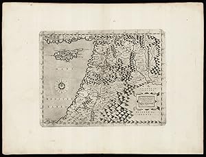
La nuova et esatta descrittione della soria, e della Terra Santa.
Verlag: Paolo Forlani,, Venetia,, 1566
Anbieter: Daniel Crouch Rare Books Ltd, London, Vereinigtes Königreich
Verbandsmitglied: ABA ILAB PBFA
Bewertung:

Karte
Forlani's map of the Holy Land Double-page engraved map. Printed from a possible discarded first issue plate, with the date in the title cartouche in Roman numerals, rather than Arabic, and with the line break after 'esatta' in the title. An unusual map showing the coast of the Holy Land with Cyprus, and the Levant coast to the south of the Dead Sea, engraved and published by Paolo Forlani. The map is based on Martin Waldseemüller's cartography in the 1513 edition of Ptolemy's 'Geographia': Forlani probably saw Giordano Ziletti's edition published in Venice in 1561, enlarged it and added the decorative title cartouche and the wind rose. The variant with Arabic numerals appears in two states, the second published by Donato Bertelli. There are institutional examples in the Danish National Library, Leiden University Library, National Library of Israel and the Bibliothčque nationale de France. Laor, Holy Land, 864; Meurer, Strabo, p.123; Tooley, Italian Atlases, 436; Woodward, Forlani, 56; Zacharakis 1536.
-
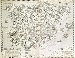
Zustand: ACEPTABLE. Importante y raro mapa antiguo de Espańa, sin título, del siglo XVI, atribuido a Forlani. Paolo Forlani fue un grabador y editor de imprenta veronés activo en Venecia entre los ańos 1560 y 1574. Fue uno de los miembros más destacados del grupo de cartógrafos conocido como "Escuela Lafreri"en Italia. Forlani mantuvo relaciones comerciales con los principales editores de material cartográfico de la época, entre ellosAntonio Lafrery,Giovanni Orlandi,Pietro de Nobili,Francesco Valegio, la familiaBertelli, entre otros. Formato (cm): 44x55.
-
De disegni delle piu illustri cittŕ, et fortezze del mondo. Parte I, la quale ne contiene cinquanta, con una breve historia delle origini, et accidenti loro, secondo l ordine de tempi; raccolta da M. Giulio Ballino.
Verlag: Venetiis: Bolognini Zalterii typiis, et formis, MDLXIX [1569]., 1569
Erstausgabe
Hardcover. Zustand: Fine. 1st Edition. 4to (271 x 209 mm., 10-3/4 x 8-1/4 inches): [4], [206] pages; engraved title-page by Nicolo Nelli, dedication leaf, manuscript index in early ink on verso of first map, and 53 mostly double-page engraved maps, city plans, fortifications and battle scenes with letterpress text in Italian on versos. Bound in contemporary vellum, gilt morocco spine label; early ink shelf marks on spine, very light general wear; pencil annotations to front pastedown, plan of Comar trimmed to plate and mounted to leaf (as issued), plans of Nettuno and Jerusalem with a small amount of period hand-coloring, plans of Perpignano and Constantinople each with a small tear at centerfold, and light intermittent foxing. Includes an additional double-page engraved plan of Perpignano, "Disegno della piazza et assedio di Perpignano", by Horatio Marinari, 1642 bound in after chapter on Perpignano. ATTRACTIVE COPY OF RARE AND IMPORTANT ITALIAN ATLAS, WITH MANY CITY PLANS BY PAOLO FORLANI AND DOMENICO ZENOI. Little is known about Giulio Ballino, Italian humanist and scholar who compiled the work and wrote the text. He was an associate of Paolo Manuzio (1512-1574), who mentions him in correspondence in the 1560s as working for him in various capacities, including corrector and editor (cf. Sbriziolo). Ballino s literary activity was primarily as a popularizer, translating many Greek philosophical and theological works into Italian. Printer and publisher Bolognino Zaltieri used the plates of several different engravers throughout the book, many being plans by Paolo Forlani (active 1560-1577) and Domenico Zenoi (active 1560-1580) that first appeared just two years earlier in Forlani s Il primo libro delle cittŕ, et fortezze principali del mondo (1567). The chart of Europe is by Girolamo Olgiato (active 1567-1575); Mexico City (here called "Timistitano", i.e. Tenochtitlan) is the only plan in the atlas of a site in the western hemisphere. The map of Central Europe and a marine chart of Europe by Olgiato are followed by views or battle plans of Venice, Fano, Mirandola, Florence, Siena, ancient Rome, modern Rome, Borgo di Roma, Castel Sant'Angelo, Ostia, Nettuno, Civitella, Vicovaro, Naples, Messina, Genoa, Parma, Piacenza, Milan, Crescentino, Paris, Perpignan (with an additional plan from 1642), Metz, Thionville, Cales, Guines, Antwerp, Gravelines, Augsburg, Frankfurt, Geneva, Gotha, Wittenberg, Vienna, Eger, Gyor, Comar, Gyula, Tokaji, Sziget, Zsaka, Constantinople, the Grand Turk and his army, Jerusalem, Tiberias, Malta (fortification), Malta (siege), Tripoli, Zerbe, Peńon de Velez de la Gomera, and Mexico City. REFERENCES: Cremonini 4; Lia Sbriziolo, "Giulio Ballino", Treccani Dizionario Biografico degli Italiani, vol. 5 (1963) (online); R. V. Tooley, "Maps in Italian Atlases of the Sixteenth Century, being a comparative list of the Italian maps issued by Lafreri, Forlani, Duchetti, Bertelli and others, found in atlases", Imago Mundi 3 (1939): pp. 12-47. Book.
-
![Bild des Verkäufers für Venetia AL SIG. GIROLAMO MVRARI, / Paolo Forlani Veronese. / VENETIA Cittŕ marauigliosa, Magnifico Signor mio, / da tutto l'uniuerso per fama conosciuta, et celebrata, ŕ richiesta / di molti honorati Gentil'huomeni con non poca mia diligentia č / stata da me intagliata in rame in questa commoda, et picciola for= / ma, accio che cadauno possi sopra di questa carta intierame[n]te / considerarla: hauendo io, ŕ maggior instruttione segnate con / numeri le parti piů notabili liquali di sotto riscontrati dimonstra= / no tutte le particolaritŕ, che l'huomo disidera di sapere. / Questa mia fatica, quale essa si sia, ho io uoluto mandar fuori sotto l'om= / bra del nome di V[ostra]. S[ignoria]. & per dimonstrarle in parte quanto desidero di seruirla, / et honorarla; & per molte altre cagioni, che per hora no[n] accade di scri- / uere in cosi picciolo, et breue campo: Ben č uero, che io mi riputerň ŕ fauor / singolarissimo, se questa mia carta sara da lei accettata con quel generoso / animo, che zum Verkauf von Daniel Crouch Rare Books Ltd](https://pictures.abebooks.com/inventory/md/md30793852688.jpg)
Venetia AL SIG. GIROLAMO MVRARI, / Paolo Forlani Veronese. / VENETIA Cittŕ marauigliosa, Magnifico Signor mio, / da tutto l'uniuerso per fama conosciuta, et celebrata, ŕ richiesta / di molti honorati Gentil'huomeni con non poca mia diligentia č / stata da me intagliata in rame in questa commoda, et picciola for= / ma, accio che cadauno possi sopra di questa carta intierame[n]te / considerarla: hauendo io, ŕ maggior instruttione segnate con / numeri le parti piů notabili liquali di sotto riscontrati dimonstra= / no tutte le particolaritŕ, che l'huomo disidera di sapere. / Questa mia fatica, quale essa si sia, ho io uoluto mandar fuori sotto l'om= / bra del nome di V[ostra]. S[ignoria]. & per dimonstrarle in parte quanto desidero di seruirla, / et honorarla; & per molte altre cagioni, che per hora no[n] accade di scri- / uere in cosi picciolo, et breue campo: Ben č uero, che io mi riputerň ŕ fauor / singolarissimo, se questa mia carta sara da lei accettata con quel generoso / animo, che
Verlag: ex aenis formis Bolognini Zalterii,, Venice,, 1566
Anbieter: Daniel Crouch Rare Books Ltd, London, Vereinigtes Königreich
Verbandsmitglied: ABA ILAB PBFA
Bewertung:
Karte
Forlani's magnificent plan of Venice Forlani state 4, Zaltieri state 3, separately issued. 2 sheets joined. Engraved view (355 by 735mm) above 23-line engraved key (horizontal separation between view and text repaired, old folds, close-cropped, left and right-hand margins with minor repairs). Magnificent, large-scale, bird's-eye view of Venice, first published in 1565, this is the third issue to bear Zaltieri's imprint and features the printed impressions of a horizontal row of rivets where the printers had attempted to join the engraved plates of the view and the key. Shown from the same perspective as Jacopo de' Barbari's monumental woodcut map of c1500, Venice is seen rising like Venus fully formed from the lagoon, witnessed by an array of satellite islands and watercraft, the Venetian mainland compressed to a thin band at the horizon and to the left. Each canal, bridge and building is meticulously depicted and named in the comprehensive key below, so that contemporaries could have recognized each house and every parish or district, practically identifying every resident in the city to the locals. At the close of the fifteenth-century, Venice was the capital of a vast empire, a mercantile centre and a departure point for travellers to the East. Located at the crossroads between East and West, Venice was a destination for foreign merchants and pilgrims. The Campanile and the Piazza San Marco, the Rialto Bridge, and other icons of the city, familiar to the foreigner, make this view of Venice accessible to them too. It is not surprising therefore that the lagoon is filled with every kind of boat, from gondola to the impressive barge of the Doge, and even an English barque. Paolo Forlani (fl.1560-1574), was a Venetian engraver and publisher of many significant maps and charts in the Renaissance. It was in Italy, and particularly in Venice, that the map trade, which was to influence profoundly the course of cartographic history, was most highly developed during the first half of the sixteenth-century. Forlani was one of the leading mapmakers of the Lafreri school a name given to a loose collection of mapmakers, publishers and engravers working in Rome and Venice between 1540 and 1580. Little is known about Forlani's life, except that he originated from Verona, and was active in Venice between 1560-1574. He was somewhat unusual in being not only a mapmaker, but also an engraver, publisher and mapseller. He was evidently in much demand during his time in Venice as we know that he was employed by no fewer than four prominent publishers - Giovanni Francesco Camocio, Ferrando Bertelli and Bolgnini Zaltieri from Venice, and Claudio Duchetti from Rome. Printed by Bolognini Zaltieri, who is most famous for his map of North America, "Il Disegno del discoperto della nova Franza" published simultaneously as this view of Venice in 1566, and which is the earliest printed map devoted solely to North America, and also reduced from a much larger predecessor, Gastaldi's large nine sheet map, printed to accompany his pamphlet "La Universale Descrittione del Mondo. Other maps published by him include a map of Ireland, of the Holy Land, and two plans of Tunis. He also issued a series of maps of the individual provinces of the Low Countries, copied from Tramezini. In his dedicatory text Forlani draws veiled comparison to the larger work of his predecessor de' Barbari by pointing out the convenience of the smaller and finer form of printing from copper that would become the format for future maps of Venice, such as Braun and Hogenberg's birds-eye view of 1572. IM III, [582]; Woodward, 42.03; Novacco 142 (ill); see Wilson "Venice, print, and the early modern icon", in Urban History, 33, 1, 2006.
-

Il Disegno del discoperto della nova Franza, il quale s'Ë havuto ultimamente dalla novissima navigatione dË Franzesi in quel luogo.: Nel quale si vedono tutti l'Isole, Porti, Capi, et luoghi fra terra che in quella sono
Verlag: Bolognino Zaltieri, Venice, 1560
Anbieter: libreria antiquaria perini Sas di Perini, Verona, VR, Italien
Bewertung:
Kunst / Grafik / Poster
Copper engraving, mm 280x400, signe and dated Venetjis Ęneis formis Bolognini Zalterij Anno. MDLXVI (1566).Perfect wide margined copy with original marginsA MILESTONE IN CARTOGRAPHY OF NORTH AMERICA. THE FIRST MAP ENTIRELY DEVOTED TO THE CONTINENT AND THE FIRST DETAILED MAP TO SHOW THE STRAIT OF ANIAN SEPARATING ASIA AND AMERICA. The map was engraved by the veronese Paolo Forlani, as recently stated by Woodward, and not by Bolognino Zaltieri as previously attributed, who published the second state (like ours) adding his name to the plate. It is the first detailed available map to depict the Strait of Anian; a few previous maps had already depicted the Strait of Anian, (whose name origins from a Marco Polo's 1559 edition), but not with such detail, being all world maps. Forlani based his map largely on the western part of a Gastaldi world map published from 1561, even if important sources are also Cartier's discoveries (1534-42), and some spanish explorations, like the Francisco Vasques de Coronado one (1540-42):Tooley, "Maps in Italian Atlases of the Sixteenth Century," Imago Mundi 3 (1939), 80; David Woodward, "The Forlani Map of North America," Imago Mundi 46 (1994): 29-40; Burden, The Mapping of North America, 33; Meurer (Strabo) 191; Cohen, "Mapping of the West", pages 29-30. Nr.cat: Cod 3494.
-
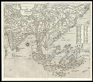
Il disegno della terza parte dell'Asia.
Verlag: 1562 and c1568]., [Venice,, 1562
Anbieter: Daniel Crouch Rare Books Ltd, London, Vereinigtes Königreich
Verbandsmitglied: ABA ILAB PBFA
Bewertung:
Karte
Gastaldi's seminal map of Southeast Asia Engraved map on three sheets joined, bearing three watermarks, upper left sheet with ladder in shield under cross pommy B (Woodward 256), upper right with lamb, paschal with straight standard C (Woodward 48), lower sheet, only lower half of ladder in shield under six-pointed star K (Woodward 253). A fine example of Gastaldi's map Southeast Asia, the most influential map of the region published in the sixteenth century, and the first map to name Singapore; here present with the rare southern extension sheet, incorporating the Java and the lucrative Spice Islands. Giacomo Gastaldi (c1500-1567), originally from Piedmont, established himself as a cartographer in Venice, where he was given the notable title of 'Cosmographer to the Republic'. He was a prolific mapmaker, with a body of work numbering at least 109 pieces, including contributions to the 1548 Venice edition of Ptolemy's 'Geogra a', and Ramusio's 'Navigationi et viaggi'. Gastaldi's maps of Asia are considered amongst the most significant representations of the continent, as the first pieces of cartography to name, and even show, many of the areas depicted. Originating from Venice, they also reflect the Republic's dominance of early exploration, particularly in Asia. The city's crucial position allowed for Western contact with the East, although this relationship was becoming progressively threatened by the expansion of the Ottoman Empire. The present map bears the same scale bar as Gastaldi's first and second parts of Asia, and matches with their latitudes and longitudes. It has been dubbed the most influential map of the region published in the sixteenth century and, as noted by Schilder, 'in the representation of the coastlines, his maps are superior to all previous known maps of Asia, either drawn by hand or printed'. After Gastaldi's death, it was augmented by two further sheets, as in the present example, narrower in size, and with the imprint 'To be sold at the San Marco bookshop in Venice' (transl.). The map extends from central Asia to China and is particularly important for its depiction of the islands below the Equator. Alongside the Moluccas, labelled the "Isole di Ambon", Gastaldi includes a note explaining that "in these islands there are cloves, cinnamon, nutmeg, pepper, sandalwood, ambergris, and many spices" (transl.), reflecting the importance of these resources to Venetian trade. e Philippines appear as "Philippina" and Borneo in its present nomenclature; found below these is Java, labelled "Giava Magiore" to distinguish it from the fictitious "Giava Minore" added by Forlani. Significantly, this is the first map to name Singapore and Cambodia. Gastaldi's sources vary from Venetian explorers, such as Marco Polo and Pigafetta, to the records of Spanish and Portuguese voyages, most notably that of Magellan. As noted by Nordenskjöld, it is likely that he had access to the extensive library of the Fugger family, since Marcus Fugger was an acquaintance and the sole dedicatee of this map, as well as to the maps in the Sala dello Scudo, which he was commissioned to paint, thanks to his close connection with the Venetian Secretary of State. Gastaldi's maps set a new standard in cartographic representations of Asia, and formed the basis of those subsequently published by Ortelius, De Jode and Mercator. Although Bifolco records 41 examples of this map held in institutions worldwide, this map is extremely rare on the market. We have been able to trace only two examples appearing in the last 50 years. Bifolco 74 state 2; Nordenskjöld, pp. 396- 406, The Geographical Journal vol. 13, April 1899; Schilder p.7, The Map Collector 17, December 1981; Suárez, The early mapping of Southeast Asia, pp.130-157, 1999; Tooley pp.20, 21.
-
Single sheet, float mounted and framed (sheet size: 12 x 17 1/8 inches; 9 4/8 x 14 2/8 inches to the neat line, full margins showing the plate mark). Fine engraved map of the Atlantic Ocean by Paolo Forlani, decorated with a fine central compass rose and numerous rhumb lines. First edition, first issue with the imprint dated "M.D.L.X". A very important map of the Atlantic Ocean, showing the coastlines of the Americas from Labrador to Brazil, western Europe and western Africa, north from the Tropic of Capricorn. It is derived from Nicolas de Nicolai's map which he published in his French translation of Pedro de Medina's 'Arte de Navegar' in 1554. Nicolas de Nicolai had travelled extensively in the service of the French King, "usually as a spy" (Burden). His map shows clearly his knowledge of the Cartier's voyages up the St. Lawrence River. Camocio published a number of Forlani's most important and celebrated maps. Following in the footsteps of his great colleague Giacomo Gastaldi, Paolo Forlani was a Venetian engraver and publisher of many significant maps and charts in the period of the Renaissance. It was in Italy, and particularly in Venice, that the map trade, which was to influence profoundly the course of cartographic history, was most highly developed during the first half of the 16th century. Venice was the most active port in the world, and successful trading expeditions necessitated accurate maps. Venetian ships made regular trading voyages to the Levant and into the Black Sea, to the ports of Spain and Portugal, and along the coasts of Western Europe. In the 15th century the city had already become a clearing-house for geographical information, and the development of cartography in the city was further impelled by the accomplishment of Venetian printers and engravers. Forlani was perhaps the most prolific producer of maps in the mid-16th century, and largely responsible for diffusing advanced geographical information to other parts of Europe. Burden 27; Karrow 59/4.1; Tooley:1939 no.77; Woodward:1990 no.3.01.