
Gesamtpreis (1 Artikel Artikel):
Versandziel:

SENEX JOHN (177 Ergebnisse)
Direkt zu den wichtigsten Suchergebnissen
Produktart
- Alle Produktarten
- Bücher (73)
- Magazine & Zeitschriften
- Comics
- Noten
- Kunst, Grafik & Poster (9)
- Fotografien
- Karten (95)
-
Manuskripte &
Papierantiquitäten
Zustand
Einband
Weitere Eigenschaften
Gratisversand
Land des Verkäufers
Verkäuferbewertung
-

PAP. Zustand: New. New Book. Shipped from UK. Established seller since 2000.
Mehr Angebote von anderen Verkäufern bei AbeBooks
Neu ab EUR 15,55
-

A Short Account of the First Settlement of the Provinces of Virginia, Maryland, New York, New Jersey and Pennsylvania, by the English: To Which Is Annexed a Map of Maryland, According to the Bounds Mentioned in the Charter, and Also of the Adjacent Countr
Verlag: Legare Street Press, 2022
ISBN 10: 1018097848ISBN 13: 9781018097848
Buch Print-on-Demand
Paperback / softback. Zustand: New. This item is printed on demand. New copy - Usually dispatched within 5-9 working days.
-
![Beispielbild für A New General Atlas; Containing a Geographical and Historical Account of All the Empires; Kingdoms; and Other Dominions of the World [microform] : With the Natural History and Trade of Each Country : zum Verkauf von Ria Christie Collections](https://pictures.abebooks.com/isbn/9781014319487-de-300.jpg)
A New General Atlas; Containing a Geographical and Historical Account of All the Empires; Kingdoms; and Other Dominions of the World [microform] : With the Natural History and Trade of Each Country :
Verlag: Legare Street Press, 2021
ISBN 10: 101431948XISBN 13: 9781014319487
Anbieter: Ria Christie Collections, Uxbridge, Vereinigtes Königreich
Bewertung:

Buch Print-on-Demand
Zustand: New. PRINT ON DEMAND Book; New; Fast Shipping from the UK. No. book.
Mehr Angebote von anderen Verkäufern bei AbeBooks
Neu ab EUR 20,84
Gebraucht ab EUR 43,36
Mehr entdecken Softcover
-
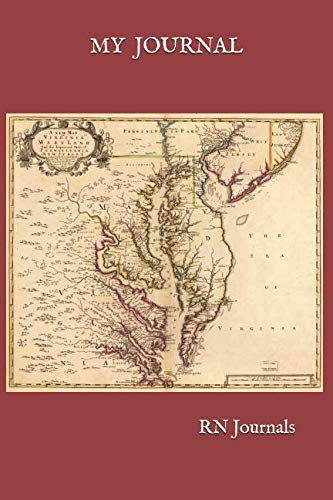
MY JOURNAL (RN Journals)
Verlag: Independently published, 2018
ISBN 10: 172024040XISBN 13: 9781720240402
Buch
Paperback. Zustand: Brand New. Senex, John (illustrator). 400 pages. 9.00x6.00x1.00 inches. In Stock.
-
![Bild des Verkäufers für A New General Atlas, Containing a Geographical and Historical Account of All the Empires, Kingdoms, and Other Dominions of the World [microform]: With (Hardback or Cased Book) zum Verkauf von BargainBookStores](https://pictures.abebooks.com/inventory/md/md31404992980.jpg)
Hardback or Cased Book. Zustand: New. A New General Atlas, Containing a Geographical and Historical Account of All the Empires, Kingdoms, and Other Dominions of the World [microform]: With 1.08. Book.
Mehr Angebote von anderen Verkäufern bei AbeBooks
Neu ab EUR 33,91
-

A new general atlas, containing a geographical and historical account of all the empires, kingdoms, and other dominions of the world
Verlag: Gale Ecco, Print Editions, 2010
ISBN 10: 1171478577ISBN 13: 9781171478577
Buch Print-on-Demand
PAP. Zustand: New. New Book. Shipped from UK. THIS BOOK IS PRINTED ON DEMAND. Established seller since 2000.
Mehr Angebote von anderen Verkäufern bei AbeBooks
Neu ab EUR 38,09
-
![Bild des Verkäufers für Itineraire de toutes les routes de l'Angleterre, revues, corrigees et augmentees, avec les additions de Bowles 1766 [LeatherBound] zum Verkauf von True World of Books](https://pictures.abebooks.com/inventory/md/md31617545870.jpg)
LeatherBound. Zustand: New. LeatherBound edition. Condition: New. Reprinted from edition. Leather Binding on Spine and Corners with Golden leaf printing on spine. Bound in genuine leather with Satin ribbon page markers and Spine with raised gilt bands. A perfect gift for your loved ones. NO changes have been made to the original text. This is NOT a retyped or an ocr'd reprint. Illustrations, Index, if any, are included in black and white. Each page is checked manually before printing. As this print on demand book is reprinted from a very old book, there could be some missing or flawed pages, but we always try to make the book as complete as possible. Fold-outs, if any, are not part of the book. If the original book was published in multiple volumes then this reprint is of only one volume, not the whole set. Sewing binding for longer life, where the book block is actually sewn (smythe sewn/section sewn) with thread before binding which results in a more durable type of binding. Pages: 335.
-

A new General Atlas, Containing a Geographical and Historical Account of all the Empires, Kingdoms, and Other Dominions of the World (Hardback or Cased Book)
Verlag: Gale Ecco, Print Editions 4/25/2018, 2018
ISBN 10: 1385797347ISBN 13: 9781385797341
Buch
Hardback or Cased Book. Zustand: New. A new General Atlas, Containing a Geographical and Historical Account of all the Empires, Kingdoms, and Other Dominions of the World 2.15. Book.
Mehr Angebote von anderen Verkäufern bei AbeBooks
Neu ab EUR 41,78
-
![Bild des Verkäufers für Geography anatomiz'd : or, The geographical grammar. Being a short and exact analysis of the whole body of modern geography, after a new and curious method . (1741) [LeatherBound] zum Verkauf von True World of Books](https://pictures.abebooks.com/inventory/md/md31618722131.jpg)
LeatherBound. Zustand: New. LeatherBound edition. Condition: New. Reprinted from 1741 edition. Leather Binding on Spine and Corners with Golden leaf printing on spine. Bound in genuine leather with Satin ribbon page markers and Spine with raised gilt bands. A perfect gift for your loved ones. NO changes have been made to the original text. This is NOT a retyped or an ocr'd reprint. Illustrations, Index, if any, are included in black and white. Each page is checked manually before printing. As this print on demand book is reprinted from a very old book, there could be some missing or flawed pages, but we always try to make the book as complete as possible. Fold-outs, if any, are not part of the book. If the original book was published in multiple volumes then this reprint is of only one volume, not the whole set. Sewing binding for longer life, where the book block is actually sewn (smythe sewn/section sewn) with thread before binding which results in a more durable type of binding. Pages: 510 Gordon, Patrick, fl. 1700,Senex, John, d. 1740,Adams, John, 1735-1826, former owner. BRL,John Adams Library (Boston Public Library) BRL.
-
![Bild des Verkäufers für Geography anatomiz'd, or, The geographical grammar : being a short and exact analysis of the whole body of modern geography . : collected from the best authors and illustrated with divers maps [LeatherBound] zum Verkauf von True World of Books](https://pictures.abebooks.com/inventory/md/md31533287194.jpg)
LeatherBound. Zustand: New. LeatherBound edition. Condition: New. Reprinted from 1722 edition. Leather Binding on Spine and Corners with Golden leaf printing on spine. Bound in genuine leather with Satin ribbon page markers and Spine with raised gilt bands. A perfect gift for your loved ones. NO changes have been made to the original text. This is NOT a retyped or an ocr'd reprint. Illustrations, Index, if any, are included in black and white. Each page is checked manually before printing. As this print on demand book is reprinted from a very old book, there could be some missing or flawed pages, but we always try to make the book as complete as possible. Fold-outs, if any, are not part of the book. If the original book was published in multiple volumes then this reprint is of only one volume, not the whole set. Sewing binding for longer life, where the book block is actually sewn (smythe sewn/section sewn) with thread before binding which results in a more durable type of binding. Pages: 514 Language: English.
-
![Bild des Verkäufers für Road Strip Map of the Road from Oakham via Nottingham to Barnsley, Huddersfield via Skipton to Ricmond via Cirencester and Burford] from 'Les routes d'Ogilby par l'Angleterre revues, corrigees, augment es, & reduites, par Senex en 101 cartes'map , engraved on both sides of the sheet, Plates 50/51. zum Verkauf von R.G. Watkins Books and Prints](https://pictures.abebooks.com/inventory/md/md22904456978.jpg)
Road Strip Map of the Road from Oakham via Nottingham to Barnsley, Huddersfield via Skipton to Ricmond via Cirencester and Burford] from 'Les routes d'Ogilby par l'Angleterre revues, corrigees, augment es, & reduites, par Senex en 101 cartes'map , engraved on both sides of the sheet, Plates 50/51.
Verlag: Paris: G.L le Rouge, 1759. 6.25 x 8.5in, 1759
Anbieter: R.G. Watkins Books and Prints, Ilminster, SOMER, Vereinigtes Königreich
Bewertung:
Karte
No Binding. No Jacket. Hand-coloured engraved map, Map from a French version of John Senex's reduced revision of John Ogilby's Britannia, by Georges-Louis le Rouge.
-

A Short Account of the First Settlement of the Provinces of Virginia, Maryland, New York, New Jersey and Pennsylvania, by the English: To Which Is Annexed a Map of Maryland, According to the Bounds Mentioned in the Charter, and Also of the Adjacent Countr
Verlag: Legare Street Press, 2022
ISBN 10: 1018092897ISBN 13: 9781018092898
Buch Print-on-Demand
Hardback. Zustand: New. This item is printed on demand. New copy - Usually dispatched within 5-9 working days.
-
![Bild des Verkäufers für A voyage into the Levant, perform'd by command of the late French king : containing the antient and modern state of the islands of the archipelago : as also of Constantinople, the coasts of the Black Sea, Armenia, Georgia, the frontiers of Persia, and Asia Minor : with plans of the principal towns and places of note : an account of the genius, manners, trade, and religion of the respective people inhabiting those parts : and an explanation of variety of medals and antique monuments . Volume 2 [LeatherBound] zum Verkauf von True World of Books](https://pictures.abebooks.com/inventory/md/md31534387994.jpg)
A voyage into the Levant, perform'd by command of the late French king : containing the antient and modern state of the islands of the archipelago : as also of Constantinople, the coasts of the Black Sea, Armenia, Georgia, the frontiers of Persia, and Asia Minor : with plans of the principal towns and places of note : an account of the genius, manners, trade, and religion of the respective people inhabiting those parts : and an explanation of variety of medals and antique monuments . Volume 2 [LeatherBound]
Erscheinungsdatum: 2023
Buch Print-on-Demand
LeatherBound. Zustand: New. LeatherBound edition. Condition: New. Reprinted from 1718 edition. Leather Binding on Spine and Corners with Golden leaf printing on spine. Bound in genuine leather with Satin ribbon page markers and Spine with raised gilt bands. A perfect gift for your loved ones. NO changes have been made to the original text. This is NOT a retyped or an ocr'd reprint. Illustrations, Index, if any, are included in black and white. Each page is checked manually before printing. As this print on demand book is reprinted from a very old book, there could be some missing or flawed pages, but we always try to make the book as complete as possible. Fold-outs, if any, are not part of the book. If the original book was published in multiple volumes then this reprint is of only one volume, not the whole set. Sewing binding for longer life, where the book block is actually sewn (smythe sewn/section sewn) with thread before binding which results in a more durable type of binding. Pages: 566 Volume 2 Language: English.
-
![Bild des Verkäufers für A voyage into the Levant, perform'd by command of the late French king : containing the antient and modern state of the islands of the archipelago : as also of Constantinople, the coasts of the Black Sea, Armenia, Georgia, the frontiers of Persia, and Asia Minor : with plans of the principal towns and places of note : an account of the genius, manners, trade, and religion of the respective people inhabiting those parts : and an explanation of variety of medals and antique monuments . Volume 1 [LeatherBound] zum Verkauf von True World of Books](https://pictures.abebooks.com/inventory/md/md31534385519.jpg)
A voyage into the Levant, perform'd by command of the late French king : containing the antient and modern state of the islands of the archipelago : as also of Constantinople, the coasts of the Black Sea, Armenia, Georgia, the frontiers of Persia, and Asia Minor : with plans of the principal towns and places of note : an account of the genius, manners, trade, and religion of the respective people inhabiting those parts : and an explanation of variety of medals and antique monuments . Volume 1 [LeatherBound]
Erscheinungsdatum: 2023
Buch Print-on-Demand
LeatherBound. Zustand: New. LeatherBound edition. Condition: New. Reprinted from 1718 edition. Leather Binding on Spine and Corners with Golden leaf printing on spine. Bound in genuine leather with Satin ribbon page markers and Spine with raised gilt bands. A perfect gift for your loved ones. NO changes have been made to the original text. This is NOT a retyped or an ocr'd reprint. Illustrations, Index, if any, are included in black and white. Each page is checked manually before printing. As this print on demand book is reprinted from a very old book, there could be some missing or flawed pages, but we always try to make the book as complete as possible. Fold-outs, if any, are not part of the book. If the original book was published in multiple volumes then this reprint is of only one volume, not the whole set. Sewing binding for longer life, where the book block is actually sewn (smythe sewn/section sewn) with thread before binding which results in a more durable type of binding. Pages: 638 Volume 1 Language: English.
-
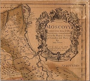
Moscovy Corrected from ye Observations communicated to the Royal Society of London and Paris.
Verlag: T. Bowles, John Bowles and Robt. Sayer, 1712
Karte
No Binding. Zustand: Fair. MOSCOVY, SENEX, 1712 ----TITLE: Moscovy Corrected from ye Observations communicated to the Royal Society of London and Paris. ----PUBLICATION DETAILS: By John Senex. Sold by him at the Globe. . . London 1712. 38 x 25 inches. At the bottom of the map is a note: In the Year 1685 ye Czars Army found certain Ancient Monuments near the place where Ptolemy places the Altars of Alexander. At the upper right is an ornate cartouche showing a Russian sleigh, a hunter, and wildlife. This is not the London: T. Bowles, John Bowles and Robt. Sayer, 1712 edition. ----GEOGRAPHY: This is a large format map showing the area from the White Sea to the Ukraine filled with detail of the topography, roads, cities, tiny villages and nomadic encampments. Moscovy is also known as The Principality of Moscow, the Grand Principality of Moscow, Muscovite Rus, or Muscovite Russia. The English names Moscow and Muscovy for the city, the principality, and the river, descend from post-classical Latin Moscovia. In Latin, the Moscow principality was also historically referred to as Ruthenia Alba (White Ruthenia). White Ruthenia is an historical reference for the territory in the eastern part of present-day Belarus. Belarus is a landlocked country in Eastern Europe. It is bordered by Russia to the east and northeast, Ukraine to the south, Poland to the west, and Lithuania and Latvia to the northwest. ----CONDITION: Cut into 15 segments, mounted on cloth, and folded with the title cartouche exposed. P Narrow moisture stain running down central panels. Fair condition. -----M2401.
-
Zustand: Fair. Chipping Campden Evesham Worcester Ludlow Montgomery SENEX #44 road map 1719. Antique engraved copperplate road strip map; John Senex (1719). 17.0 x 21.5cm, 6.75 x 8.5 inches; this is a folding map. Condition: Fair: Waterstained. There is nothing printed on the reverse side, which is plain. The map shows the route passing through the following towns: Chipping Campden - Willersey - Bengeworth - Evesham - Wyre Piddle - Worcester - Hallow - Great Witley - Stockton-on-Teme - Newnham Bridge - Tenbury - Ludlow - Newton - Bishop's Castle - Montgomery, and the following counties: Gloucestershire - Worcestershire - Shropshire - Montgomeryshire.
-
Zustand: Good. Puckeridge Cambridge Ely Downham Market King's Lynn SENEX #43 road map 1719. Antique engraved copperplate road strip map; John Senex (1719). 17.5 x 21.0cm, 6.75 x 8.25 inches; this is a folding map. Condition: Good. Blemish in margin. There is nothing printed on the reverse side, which is plain. The map shows the route passing through the following towns: Puckeridge - Barkway - Fowlmere - Trumpington - Cambridge - Chesterton - Milton - Stretham - Ely - Southery - Downham Market - Watlington - Seething - King's Lynn, and the following counties: Hertfordshire - Cambridgeshire - Suffolk - Norfolk.
-
Zustand: Fair-to-Good. Islip Chipping Norton Pershore Worcester Bromyard SENEX #2 road map 1719. Antique engraved copperplate road strip map; John Senex (1719). 17.0 x 21.5cm, 6.75 x 8.5 inches; this is a folding map. Condition: Fair-to-Good: Blemish. Spot in margin. There is nothing printed on the reverse side, which is plain. The map shows the route passing through the following towns: Islip - Enstone - Chipping Norton - Little Compton - Moreton-in-Marsh - Broadway - Pershore - Worcester - Bromyard - Bredenbury, and the following counties: Oxfordshire - Gloucestershire - Worcestershire - Herefordshire.
-
Zustand: Good. Newcastle-under-Lyme Warrington Ashton/Lyne Wigan Preston SENEX 37 road map 1719. Antique engraved copperplate road strip map; John Senex (1719). 17.5 x 21.0cm, 6.75 x 8.25 inches; this is a folding map. Condition: Good. Centrefold has been reinforced verso with tape. There is nothing printed on the reverse side, which is plain. The map shows the route passing through the following towns: Darlaston - Tittensor - Trentham - Newcastle-under-Lyme - Talke - Brereton - Cranage - Stublach - Whitley - Warrington - Newton-le-Willows - Ashton-under-Lyne - Wigan - Standish - Whittle-le-Woods - Charnock Richard - Leyland - Preston - Barton - Garstang, and the following counties: Staffordshire - Cheshire - Lancashire.
-
[Plate #3: The road via Leominster - Kingsland - Presteigne - Rhayader - Aberystwyth] - [The Road from London to Aberistwith on the Sea Coast in Cardiganshire, wherein are included the roads both to Oxford and Worcester actually surveyed]
Erscheinungsdatum: 1719
Karte
Zustand: Good. Leominster Kingsland Presteigne Rhayader Aberystwyth SENEX #3 road map 1719. Antique engraved copperplate road strip map; John Senex (1719). 18.0 x 21.5cm, 7 x 8.5 inches; this is a folding map. Condition: Good. There is nothing printed on the reverse side, which is plain. The map shows the route passing through the following towns: Leominster - Kingsland - Presteigne - Rhayader - Aberystwyth, and the following counties: Herefordshire - Radnorshire - Cardiganshire.
-
Zustand: Good. London Maidenhead Reading Newbury Hungerford Marlborough SENEX #10 road map 1719. Antique engraved copperplate road strip map; John Senex (1719). 18.0 x 21.5cm, 7 x 8.5 inches; this is a folding map. Condition: Good. Spot. There is nothing printed on the reverse side, which is plain. The map shows the route passing through the following towns: London - Hammersmith - Turnham Green - Brentford - Hounslow - Colnbrook - Maidenhead - Twyford - Reading - Theale - Woolhampton - Thatcham - Newbury - Hungerford - Ramsbury - Marlborough, and the following counties: London - Middlesex - Buckinghamshire - Berkshire - Wiltshire.
-
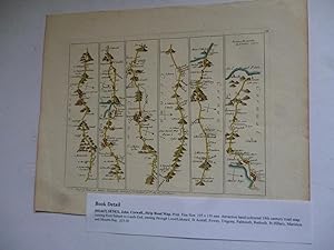
Corwall.Strip Road Map
Anbieter: Roger Collicott Books, Widecombe in the Moor, DEVON, Vereinigtes Königreich
Bewertung:

Kunst / Grafik / Poster
Print. Zustand: Fine. Size: 195 x 150 mm. Attractive hand-coloured 18th century road map running from Saltash to Lands End, passing through Looe/Liskeard, St Austall, Fowey, Tregony, Falmouth, Redruth, St Hillary, Marizion and Mounts Bay.
-
[Plate #15: The road via Abingdon - Faringdon - Lechlade - Fairford - Barnsley - Gloucester - Mitcheldean - Coleford - Monmouth] - [The Road from London to St David's and the Sea Coast in Pembrokeshire actually surveyed]
Erscheinungsdatum: 1719
Karte
Zustand: Good. Abingdon Faringdon Lechlade Fairford Gloucester Monmouth SENEX #15 road map 1719. Antique engraved copperplate road strip map; John Senex (1719). 17.0 x 22.0cm, 6.75 x 8.75 inches; this is a folding map. Condition: Good. There is nothing printed on the reverse side, which is plain. The map shows the route passing through the following towns: Abingdon - Faringdon - Lechlade - Fairford - Barnsley - Gloucester - Mitcheldean - Coleford - Monmouth, and the following counties: Berkshire - Gloucestershire - Monmouthshire.
-
[Plate #7: The road via Barmby Moor - Bawtry - Doncaster - Wentbridge - Ferrybridge - Sherburn-in-Elmet - Tadcaster - York - Boroughbridge] - [The Road from London to Barwick actually surveyed]
Erscheinungsdatum: 1719
Karte
Zustand: Good. Doncaster Ferrybridge Tadcaster York Boroughbridge SENEX #7 road map 1719. Antique engraved copperplate road strip map; John Senex (1719). 17.5 x 22.0cm, 7 x 8.5 inches; this is a folding map. Condition: Good. Blemish in margin. There is nothing printed on the reverse side, which is plain. The map shows the route passing through the following towns: Barmby Moor - Bawtry - Doncaster - Wentbridge - Ferrybridge - Sherburn-in-Elmet - Tadcaster - York - Boroughbridge, and the following counties: Nottinghamshire - Yorkshire.
-
Zustand: Good. Lincoln Hull Beverley Scarborough Bridlington Flamborough SENEX 42 road map 1719. Antique engraved copperplate road strip map; John Senex (1719). 17.0 x 21.5cm, 6.75 x 8.5 inches; this is a folding map. Condition: Good. There is nothing printed on the reverse side, which is plain. The map shows the route passing through the following towns: Lincoln - Spital-in-the-Street - Redbourne - Brigg - Barton-upon-Humber / Hull - Newland - Beverley - Watton - Driffield - Kilham - Bridlington - Flamborough, and the following counties: Lincolnshire - Yorkshire.
-
[Plate #51: The road via Bagshot - Farnham - Alton - Alresford - Twyford - North Stoneham - Southampton - Romsey - Whaddon - Salisbury] - The Road from London to Southampton continued to Salisbury commencing at Bagshot in the Road to the Lands-End
Erscheinungsdatum: 1719
Karte
Zustand: Good. Bagshot Farnham Twyford Southampton Romsey Salisbury SENEX #51 road map 1719. Antique engraved copperplate road strip map; John Senex (1719). 17.0 x 21.5cm, 6.75 x 8.5 inches; this is a folding map. Condition: Good. Small library stamp in lower margin. There is nothing printed on the reverse side, which is plain. The map shows the route passing through the following towns: Bagshot - Farnham - Alton - Alresford - Twyford - North Stoneham - Southampton - Romsey - Whaddon - Salisbury, and the following counties: Surrey - Hampshire - Wiltshire.
-
Zustand: Good. Bridgwater South Molton Barnstable Great Torrington SENEX #33 road map 1719. Antique engraved copperplate road strip map; John Senex (1719). 17.5 x 22.0cm, 6.75 x 8.75 inches; this is a folding map. Condition: Good. Toning along centrefold. There is nothing printed on the reverse side, which is plain. The map shows the route passing through the following towns: Bridgwater - West Bagborough - Dulverton - South Molton - Barnstaple - Newton Tracey - Great Torrington - Hatherleigh, and the following counties: Somerset - Devon.
-
Zustand: Good. Birmingham Dudley Bridgnorth Shrewsbury Welshpool SENEX #50 road map 1719. Antique engraved copperplate road strip map; John Senex (1719). 17.5 x 21.5cm, 6.75 x 8.5 inches; this is a folding map. Condition: Good. There is nothing printed on the reverse side, which is plain. The map shows the route passing through the following towns: Meriden - Sheldon - Birmingham - Smethwick - Oldbury - Dudley - Heathton - Bridgnorth - Much Wenlock - Cressage - Betton - Shrewsbury - Rowton Castle - Abberbury - Westbury - Welshpool, and the following counties: Warwickshire - Staffordshire - Shropshire - Montgomeryshire.
-
Zustand: Good. Basingstoke Cranborne Blandford Dorchester Weymouth SENEX #53 road map 1719. Antique engraved copperplate road strip map; John Senex (1719). 17.5 x 21.5cm, 6.75 x 8.25 inches; this is a folding map. Condition: Good. There is nothing printed on the reverse side, which is plain. The map shows the route passing through the following towns: Basingstoke - Long Sutton - Stockbridge - Broughton - West Tytherley - Downton - Cranborne - Wimborne St Giles - Tarrant Monkton - Blandford - Dorchester - Weymouth, and the following counties: Hampshire - Wiltshire - Dorset.
-
Zustand: Good. Colchester Ipswich Saxmundham Beccles Great Yarmouth SENEX #54 road map 1719. Antique engraved copperplate road strip map; John Senex (1719). 17.0 x 22.0cm, 6.75 x 8.75 inches; this is a folding map. Condition: Good. Tight left margin. There is nothing printed on the reverse side, which is plain. The map shows the route passing through the following towns: Colchester - Ardleigh - Brantham - Ipswich - Woodbridge - Wickham Market - Great Glemham - Saxmundham - Yoxford - Blythburgh - Brampton - Beccles - St Olaves - Great Yarmouth, and the following counties: Essex - Suffolk - Norfolk.
![Bild des Verkäufers für [Plate #44: The road via Chipping Campden - Willersey - Bengeworth - Evesham - Wyre Piddle - Worcester - Hallow - Great Witley - Stockton-on-Teme - Newnham Bridge - Tenbury - Ludlow - Newton - Bishop's Castle - Montgomery] - The Road from London to Montgomery in North Wales containing from London to the 4 Shire Stone in the Aberistwith Road zum Verkauf von Antiqua Print Gallery](https://pictures.abebooks.com/inventory/md/md31106552831.jpg)
![Bild des Verkäufers für [Plate #43: The road via Puckeridge - Barkway - Fowlmere - Trumpington - Cambridge - Chesterton - Milton - Stretham - Ely - Southery - Downham Market - Watlington - Seething - King's Lynn] - The Road from London to Kings-Lyn in Norfolk in which are included the Road to Cambridg and Ely commencing at Puckeridg in the Barwick Road zum Verkauf von Antiqua Print Gallery](https://pictures.abebooks.com/inventory/md/md31106561548.jpg)
![Bild des Verkäufers für [Plate #2: The road via Islip - Enstone - Chipping Norton - Little Compton - Moreton-in-Marsh - Broadway - Pershore - Worcester - Bromyard - Bredenbury] - [The Road from London to Aberistwith on the Sea Coast in Cardiganshire, wherein are included the roads both to Oxford and Worcester actually surveyed] zum Verkauf von Antiqua Print Gallery](https://pictures.abebooks.com/inventory/md/md31106563475.jpg)
![Bild des Verkäufers für [Plate #37: The road via Darlaston - Tittensor - Trentham - Newcastle-under-Lyme - Talke - Brereton - Cranage - Stublach - Whitley - Warrington - Newton-le-Willows - Ashton-under-Lyne - Wigan - Standish - Whittle-le-Woods - Charnock Richard - Leyland - Preston - Barton - Garstang] - The Road from London to Carlisle in Cumberland commencing at Daralaston Bridg in the Holy-head Road zum Verkauf von Antiqua Print Gallery](https://pictures.abebooks.com/inventory/md/md31106563478.jpg)
![Bild des Verkäufers für [Plate #3: The road via Leominster - Kingsland - Presteigne - Rhayader - Aberystwyth] - [The Road from London to Aberistwith on the Sea Coast in Cardiganshire, wherein are included the roads both to Oxford and Worcester actually surveyed] zum Verkauf von Antiqua Print Gallery](https://pictures.abebooks.com/inventory/md/md31106565401.jpg)
![Bild des Verkäufers für [Plate #10: The road via London - Hammersmith - Turnham Green - Brentford - Hounslow - Colnbrook - Maidenhead - Twyford - Reading - Theale - Woolhampton - Thatcham - Newbury - Hungerford - Ramsbury - Marlborough] - The Road from London to Bristol and continued from thence to Huntspil in Somersetshire actually surveyd zum Verkauf von Antiqua Print Gallery](https://pictures.abebooks.com/inventory/md/md31106564427.jpg)
![Bild des Verkäufers für [Plate #15: The road via Abingdon - Faringdon - Lechlade - Fairford - Barnsley - Gloucester - Mitcheldean - Coleford - Monmouth] - [The Road from London to St David's and the Sea Coast in Pembrokeshire actually surveyed] zum Verkauf von Antiqua Print Gallery](https://pictures.abebooks.com/inventory/md/md31106552828.jpg)
![Bild des Verkäufers für [Plate #7: The road via Barmby Moor - Bawtry - Doncaster - Wentbridge - Ferrybridge - Sherburn-in-Elmet - Tadcaster - York - Boroughbridge] - [The Road from London to Barwick actually surveyed] zum Verkauf von Antiqua Print Gallery](https://pictures.abebooks.com/inventory/md/md31106560618.jpg)
![Bild des Verkäufers für [Plate #42: The road via Lincoln - Spital-in-the-Street - Redbourne - Brigg - Barton-upon-Humber / Hull - Newland - Beverley - Watton - Driffield - Kilham - Bridlington - Flamborough] - [The Road from London to Flamborough in Yorkshire commencing at Stilton in the Barwick Road and showing the way to Stilton through Tamesford] zum Verkauf von Antiqua Print Gallery](https://pictures.abebooks.com/inventory/md/md31106561547.jpg)
![Bild des Verkäufers für [Plate #51: The road via Bagshot - Farnham - Alton - Alresford - Twyford - North Stoneham - Southampton - Romsey - Whaddon - Salisbury] - The Road from London to Southampton continued to Salisbury commencing at Bagshot in the Road to the Lands-End zum Verkauf von Antiqua Print Gallery](https://pictures.abebooks.com/inventory/md/md31106563480.jpg)
![Bild des Verkäufers für [Plate #33: The road via Bridgwater - West Bagborough - Dulverton - South Molton - Barnstaple - Newton Tracey - Great Torrington - Hatherleigh] - The continuation of the Road from London to Barnstable in Devonshire commencing at Bridgwater in Somersetshire and from thence continued to Barnsable and so to Hatherly zum Verkauf von Antiqua Print Gallery](https://pictures.abebooks.com/inventory/md/md31106565402.jpg)
![Bild des Verkäufers für [Plate #50: The road via Meriden - Sheldon - Birmingham - Smethwick - Oldbury - Dudley - Heathton - Bridgnorth - Much Wenlock - Cressage - Betton - Shrewsbury - Rowton Castle - Abberbury - Westbury - Welshpool] - The Road from London to Shrewsbury continued to Welshpool in North Wales commencing at Meriden in the Road to Holy Head zum Verkauf von Antiqua Print Gallery](https://pictures.abebooks.com/inventory/md/md31106565404.jpg)
![Bild des Verkäufers für [Plate #53: The road via Basingstoke - Long Sutton - Stockbridge - Broughton - West Tytherley - Downton - Cranborne - Wimborne St Giles - Tarrant Monkton - Blandford - Dorchester - Weymouth] - The Road from London to Weymouth in Dorsetshire containing from London to Basingstoke in the road to the Lands-End zum Verkauf von Antiqua Print Gallery](https://pictures.abebooks.com/inventory/md/md31106565405.jpg)
![Bild des Verkäufers für [Plate #54: The road via Colchester - Ardleigh - Brantham - Ipswich - Woodbridge - Wickham Market - Great Glemham - Saxmundham - Yoxford - Blythburgh - Brampton - Beccles - St Olaves - Great Yarmouth] - The Road from London to Yarmouth in Norfolk containing from London to Colchester in the Harwich Road zum Verkauf von Antiqua Print Gallery](https://pictures.abebooks.com/inventory/md/md31106565406.jpg)