Gesamtpreis (1 Artikel Artikel):
Versandziel:

SWANSTON, G H (72 Ergebnisse)
Direkt zu den wichtigsten Suchergebnissen
Produktart
- Alle Produktarten
- Bücher (30)
- Magazine & Zeitschriften
- Comics
- Noten
- Kunst, Grafik & Poster
- Fotografien
- Karten (42)
-
Manuskripte &
Papierantiquitäten
Zustand
- Alle
- Neu
- Antiquarisch/Gebraucht
Einband
Weitere Eigenschaften
- Erstausgabe (10)
- Signiert
- Schutzumschlag (3)
- Angebotsfoto (59)
- Kein Print-on-Demand
Land des Verkäufers
Verkäuferbewertung
-

Zustand: Good. This is an ex-library book and may have the usual library/used-book markings inside.This book has hardback covers. In good all round condition. Dust Jacket in good condition. Please note the Image in this listing is a stock photo and may not match the covers of the actual item,500grams, ISBN:
-
The Community Witness: An Exploration of Some of the Influences at Work in the New Testament Community and its Writings
Verlag: Burns & Oates, 1967
Zustand: Good. This is an ex-library book and may have the usual library/used-book markings inside.This book has hardback covers. Clean from markings. In good all round condition. Dust jacket in fair condition. Please note the Image in this listing is a stock photo and may not match the covers of the actual item,500grams, ISBN:
-
The Community Witness: An Exploration of Some of the Influences at Work in the New Testament Community and its Writings
Verlag: Burns & Oates, 1967
Zustand: Good. This is an ex-library book and may have the usual library/used-book markings inside.This book has hardback covers. In good all round condition. Dust jacket in good condition. Please note the Image in this listing is a stock photo and may not match the covers of the actual item,550grams, ISBN:
-
Single sheet. Boundaries affecting the Sardinian States Savoy/Nice to the Vaudois printed in red. Some orig h/col. The page number and the numbering of the 7 insets are from labels mounted on the map. 52 x 41 cm.
-
Single sheet. Boundaries affecting Moselle & Rhineland (Strasburg) outlined in red. Some orig h/col. The page number and the numbering of the 7 insets are printed directly on the map. The page number is in Roman numerals. 52 x 41 cm.
-
Assen, 1976. Wrps. 154 pp. ISBN 9023214269. New copy.
-
Softcover. Zustand: Very Good. Augustus Petermann (illustrator). 1846. A very well-preserved engraving by Swanston, from Petermann c.1846. Faintly hand-coloured and overall very presentable, with the print itself remaining cleana nd clear across the entire image surface. the page bears a light damp mark at lower corner and some wear along right edge from removal from binding, not encroaching significantly on the print itself, would be easily concealed by a mount. Why on Amazon do most sellers not describe their actual book? Buy with confidence and support a genuine Independent Bricks & Mortar Real Bookshop. We are Maynard & Bradley CAMBO & PBFA(now lapsed) members here in Leicester City Centre. Size: 180 x 250 mm. 1 pages. Item Type: Book. Illustrator: Augustus Petermann. Quantity Available: 1. Shipped Weight: Under 500 grams. Category: Geography & Maps; Britain/UK; 19th century; Pictures of this item not already displayed here available upon request. Inventory No: 11945.
-
Softcover. Zustand: Very Good. First Edition. An original 1872 lithograph. Overall a very presentable copy, with some minor browning and foxing to top and bottom edges, but only lightly encroaching on title and bottom edge of image, with lines and text otherwise remaining clear and bold across the entire print. Some very minor edge creases but no major signs of wear. Why on Amazon do most sellers not describe their actual book? Buy with confidence and support a genuine Independent Bricks & Mortar Real Bookshop. We are Maynard & Bradley CAMBO & PBFA(now lapsed) members here in Leicester City Centre. Size: 250 x 170 mm. 1 pages. Item Type: Book. Quantity Available: 1. Shipped Weight: Under 1 kilogram. Category: Geography & Maps; Britain/UK; 19th century; Pictures of this item not already displayed here available upon request. Inventory No: 10660.
-
Softcover. Zustand: Good. c.1852. Some mild browning and small nicks and tears around the outer margins, repaired and reinforced with conservation tape and contemporaneous paper to a good, presentable standard. The print itself remains clean and unmarked across the entire image surface, with colouring clean and attractive, overall a well-presented copy. Why on Amazon do most sellers not describe their actual book? Buy with confidence and support a genuine Independent Bricks & Mortar Real Bookshop. We are Maynard & Bradley CAMBO & PBFA(now lapsed) members here in Leicester City Centre. Size: 155 x 240 mm. 1. Item Type: Book. Quantity Available: 1. Shipped Weight: Under 500 grams. Category: Geography & Maps; Britain/UK; Modern; Inventory No: 34915.
-
ORIGINAL 1856 MAP: Ports and Harbours on the Coast of France: Cherbourg, Dieppe, Boulogne by G.H. Swanston
Verlag: London and Edinburgh, A. Fullarton and Co., 1856, 1856
Map is in very clean attractive condition. map was removed from a disbound Gazetteer of the World published in 1856 by Fullarton. Would frame well. The map itself is 23 cm x 14 cm withn the border, and sheet is 17 cm x 26 cm. Steel engraving, very fine work, with three lithographic colours: black outline, light blue, light brown. Looks to have been cleaned at some point. Would display beautifully. Paperback. No dj.
-
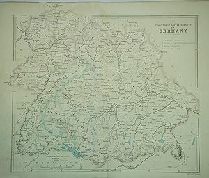
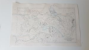
GERMANY, Archibald Fullarton & Co G.H. Swanston c1850.
Verlag: A. Fullarton & Co, London, 1850
Karte
No Binding. Zustand: Good. c1850. Published by A. Fullarton & Co, London. Description: Titled to right hand side, Independent Southern States of Germany, by G.H. Swanston, with areas named by numbers, 1. Bavaria ,2. Wurtemberg , 3. Baden , 4. Hohoenzollern (added to Prussia in 1849), 5. Hessen Darm,stadt , 6. Nassau and 7. Coburg. Condition: Good. Light wear to edges with creasing to most corners. Crease to centre line. Lightly tanned with minor light marks to margins. CARTOGRAPHER: Archibald Fullarton (fl.1833 - 1850) publisher of steel plate engraved maps. Founded A. Fullarton and Co, in Glasgow between the years 1833-1840 and rapidly expanded into London, Edinburgh and Glasgow and Dublin. Published works include the remarkable Rev Wilson's Imperial Gazetteer of Scotland andJohn Bartholomew's Imperial Map. Adopted risky strategy of re-printing work from other mapmakers, notably Bell's New and Comprehensive Gazetter of England and Wales, a collection of county maps, which were in turn copied from Samuel Lewis' Topographical English Dictionary. Led to numerous copyright disagreements around the use of other mapmakers' work. Fullarton's maps are decoratively second only to Thomas Moule. Whereas Moule's maps were highly decorated, Fullarton's maps usually included only one fine graphic, leaving the focus very much on the content of the map. ENGRAVER:
-
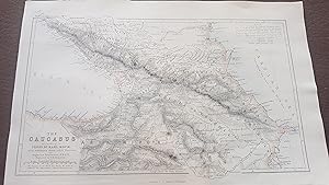
ORIGINAL 1856 MAP: The Caucasus according to Profr. Dr. Karl Koch with additions from other Sources by August Petermann
Verlag: London and Edinburgh, A. Fullerton and Co., 1856, 1856
Karte
No Binding. Zustand: Fine. Map iis in very clean attractive condition. map was removed from a disbound Gazetteer of the World published in 1856 by Fullarton. Would frame well. The map itself is 23 cm x 14 cm withn the border, and sheet is 17 cm x 26 cm. Steel engraving, very fine work, with three lithographic colours: black outline, light blue, light brown. Looks to have been cleaned at some point. Would display beautifully. Includes the Black Sea, Caspian Sea, and regions in between including Georgia.
-
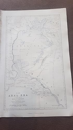
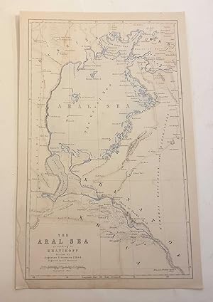
ORIGINAL 1856 MAP: The Aral Sea according to Khanikoff drawn by August Petermann
Verlag: London and Edinburgh, A. Fullerton and Co., 1856, 1856
Karte
No Binding. Zustand: Fine. The Aral Sea is a huge expanse between Kazakhstan and Uzbekistan, now almost completely dried up due to global warming, but in 1856, it's huge extent as an important sea was recorded in this historic map. Map is in very clean attractive condition. map was removed from a disbound Gazetteer of the World published in 1856 by Fullarton. Would frame well. The map itself is 23 cm x 14 cm withn the border, and sheet is 17 cm x 26 cm. Steel engraving, very fine work, with three lithographic colours: black outline, light blue, light brown. Looks to have been cleaned at some point. Would display beautifully.
-
ORIGINAL 1856 MAP of Part of Central Africa ( includes Lake Chad, part of Nigeria)
Verlag: London and Edinburgh, A. Fullerton and Co., 1856, 1856
Map itself is in very clean attractive condition within border. Included Lake Chad at the top and parts of what are today mainly the countries of Nigeria and Chad. Based on the discoveries of the explorers Clapperton, Denham, Richardson, Barth, Vogel and Baikie. Removed from a disbound Gazzetteer of the World published in 1856 by Fullarton. Drawn and Engraved by G. H. Swanston Edinburgh. The map itself is 23 cm x 14 cm within the border, and sheet is 17 cm x 26 cm . Steel engraving with three lithographic colours: black outline, light blue, light brown. Looks to have been cleaned at some point. Would display beautifully. Enquiries and comments welcome. Can be sent via DHL for a small extra charge. Africana. Paperback. No dj.
-
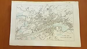
ORIGINAL 1856 MAP: City of Glasgow.
Verlag: London and Edinburgh, A. Fullerton and Co., 1856, 1856
Karte
No Binding. Zustand: Near Fine. Map itself is in very clean attractive condition within border. From a disbound Gazzetteer of the World published in 1856 by Fullarton. Easily covered by framing. Drawn and Engraved by J. Bartholomew of Edinburgh. The map itself is 23 cm x 14 cm within the border . Steel engraving with three lithographic colours: black outline, light blue, light brown. Looks to have been cleaned at some point. Would display beautifully. Enquiries and comments welcome. Can be sent via DHL for a small extra charge.
-
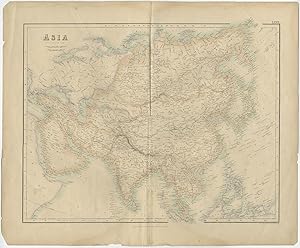
Antique Map of Asia by G.H. Swanston (c.1870)
Verlag: A. Fullarton, 1870
Anbieter: Bartele Gallery - The Netherlands, Langweer, FRL, Niederlande
Bewertung:

Karte
No Binding. Zustand: Fair. Antique map titled 'Asia'. Engraved by G.H. Swanston, published by A. Fullarton (c.1870). General age-related toning and defects. Several tears and repairs. Please study image carefully. Overall size: 56.5 x 47 cm. Image size: 49 x 38.4 cm.
-
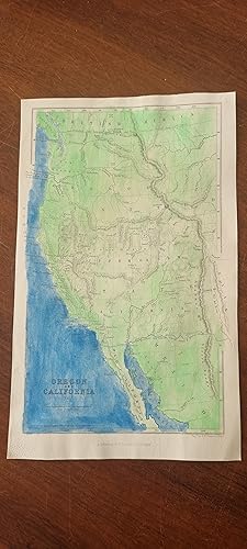
Oregon and California Map ( much later hand colour in light green and dark blue ) 1856 original steel engraving.
Verlag: London, Archibald Fullarton, 1856, 1856
Karte Erstausgabe
No Binding. Zustand: Near Fine. 1st Edition. The ORIGINAL 1856 steel engraving, from a Gazetteer of the World pubilshed by Fullarton in 1856. Map is 14 cm x 23 cm. Sheet is 26 x 17 cm. Much later hand colour in watercolour with entire land portion in light green and entire sea portion in dark blue ( a little uneven). Sheet is very clean with no foxing or tears.
-
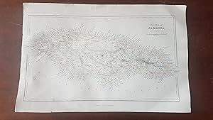
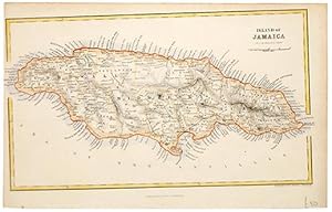
Island of Jamaica. Original 1856 map with three colour lithographic tints.
Verlag: London and Edinburgh, A. Fullarton and Co., 1856, 1856
Karte
No Binding. Zustand: Very Good. The map itself is clean.There are two closed tears on the left border of the map, in the blank area south of the island, which have been professionally repaired on the reverse. Else near fine, very good. Map itself is 23.5 cm x 13.5 cm within borders. Sheet is 16 cm x 26 cm.
-
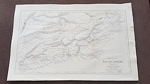
ORIGINAL 1856 MAP of the Province of Rio de Janeiro Brazil From the Map of H. Mahlmann
Verlag: London and Edinburgh, A. Fullarton and Co., 1856, 1856
Karte
No Binding. Zustand: Near Fine. Map itself is in very clean attractive condition. Drawn and Engraved by G. H. Swanston Edinburgh. The map itself is 23 cm x 14 cm within the border, and sheet is 17 cm x 26 cm . Steel engraving with three lithographic colours: black outline, light blue, light brown. Would display beautifully. Enquiries and comments welcome. Can be sent via DHL for a small extra charge.
-
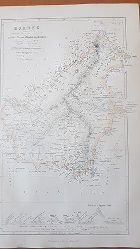
ORIGINAL 1856 MAP: Borneo by August Petermann
Verlag: London and Edinburgh, A. Fullerton and Co., 1856, 1856
Map is in very clean attractive condition. map was removed from a disbound Gazetteer of the World published in 1856 by Fullarton. Would frame well. The map itself is 23 cm x 14 cm withn the border, and sheet is 17 cm x 26 cm. Steel engraving, very fine work, with three lithographic colours: black outline, light blue, light brown. Looks to have been cleaned at some point. Would display beautifully. Has an interesting sectional view at the bottom showing the comparitive elevations of the principal mountains and places of Borneo, serving as an index to the letters in the map. Paperback. No dj.
-
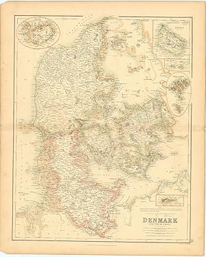
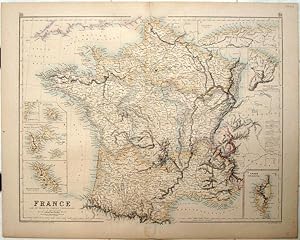
Denmark and the Duchies.
Verlag: Edinburgh London & DublinA. Fullarton & Co. c., 1862
Anbieter: Robert Frew Ltd. ABA ILAB, London, Vereinigtes Königreich
Verbandsmitglied: ABA ILAB PBFA
Bewertung:

Karte
51.7 x 41 cm. Original outline colour. Double page map with inset maps of Iceland, Bornholm, the Virgin Islands, the Faroe Islands and Santa Cruz (now St. Croix in the U.S. Virgin Islands). Some light toning to edges, generally in good condition.
-
ISLAND OF JAMAICA.
Verlag: Atlas to Gazetteer of World. A. Fullarton & Co. London. 1860, 1860
Anbieter: Peter Harrington. ABA/ ILAB., London, Vereinigtes Königreich
Verbandsmitglied: ABA ILAB PBFA
Bewertung:
Cropped left margin. Size: 23.7 x 13.1 cm. (9˝ x 5 inches) Steel engraving. Original colour. In fine condition.
-

Antique Map of Asia II by G.H. Swanston (c.1870)
Verlag: G.H. Swanston, 1870
Anbieter: Bartele Gallery - The Netherlands, Langweer, FRL, Niederlande
Bewertung:
Karte
No Binding. Zustand: Good. Antique map titled 'Asia'. Engraved by G.H. Swanston, published by A. Fullarton (c.1870). General age-related toning and defects. Tear along center fold. Please study image carefully. Overall size: 56.5 x 47 cm. Image size: 49 x 38.4 cm.
-
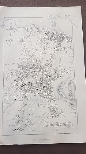
ORIGINAL 1852 MAP: Edinburgh & Leith by G.H. Swanston
Verlag: London and Edinburgh, A. Fullarton and Co., 1856, 1856
Karte Erstausgabe
No Binding. Zustand: Near Fine. 1st Edition. Map is in very clean attractive condition. map was removed from a disbound Gazetteer of the World published in 1856 by Fullarton. Would frame well. The map itself is 23 cm x 14 cm withn the border, and sheet is 17 cm x 26 cm. Steel engraving, very fine work, with three lithographic colours: black outline, light blue, light brown. Looks to have been cleaned at some point. Would display beautifully.
-
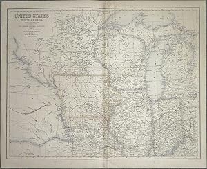
United States: North Central Section (Fullarton 1874)
Verlag: Archibald Fullerton, UK, 1874
Buch Erstausgabe
Softcover. Zustand: Very Good. Calvin, Smith & Tanner (illustrator). First Edition. An original 1874 hand-coloured lithograph taken from Fullarton's Royal Illustrated Atlas, 1874. Depicts Michigan, Illinois, Wisconsion, Iowa, Indiana, Nebraska, Minnesota, Missouri and Kentucky. Some marks of discolouration, with faint brown streaky marks from top edge along central fold line. Otherwise a very presentable copy, with some very minor spotting to margins but minimal encroachment onto the actual print, with lines and colouring remaining clear and bold across the entire surface. Some very minor nicks to edges, not imposing substantially upon the image, reinforced with high-quality conservaiton tape. Ideal for framing. Why on Amazon do most sellers not describe their actual book? Buy with confidence and support a genuine Independent Bricks & Mortar Real Bookshop. We are Maynard & Bradley CAMBO & PBFA(now lapsed) members here in Leicester City Centre. Size: 570 x 460 mm. 1 pages. Item Type: Book. Illustrator: Calvin, Smith & Tanner. Quantity Available: 1. Shipped Weight: Under 1 kilogram. Category: Geography & Maps; Britain/UK; 19th century; Pictures of this item not already displayed here available upon request. Inventory No: 10649.
-
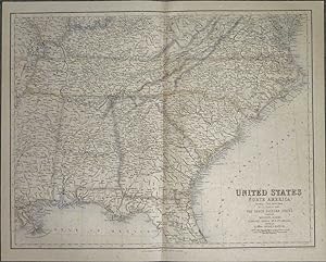
United States: South Eastern States (Fullarton 1874)
Verlag: Archibald Fullerton, UK, 1874
Buch Erstausgabe
Softcover. Zustand: Very Good. Calvin, Smith & Tanner (illustrator). First Edition. An original 1874 hand-coloured lithograph taken from Fullarton's Royal Illustrated Atlas, 1874. Depicts Mississippi, alabama, Tennessee, Georgia, Carolina, Florida, Virginia and Kentucky. Overall a very presentable copy, with some scattered foxing across the image surface, but lines and colouring otherwise remaining clear and bold across the entire print. Some very minor nicks to edges, not imposing upon the image, reinforced with high-quality conservaiton tape. Ideal for framing. Why on Amazon do most sellers not describe their actual book? Buy with confidence and support a genuine Independent Bricks & Mortar Real Bookshop. We are Maynard & Bradley CAMBO & PBFA(now lapsed) members here in Leicester City Centre. Size: 570 x 460 mm. 1 pages. Item Type: Book. Illustrator: Calvin, Smith & Tanner. Quantity Available: 1. Shipped Weight: Under 1 kilogram. Category: Geography & Maps; Britain/UK; 19th century; Pictures of this item not already displayed here available upon request. Inventory No: 10650.
-
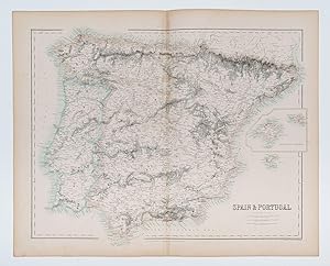
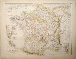
Spain & Portugal.
Verlag: Edinburgh London & DublinA. Fullarton & Co. c., 1862
Anbieter: Robert Frew Ltd. ABA ILAB, London, Vereinigtes Königreich
Verbandsmitglied: ABA ILAB PBFA
Bewertung:
Karte
40.3 x 52.5 cm. Original outline colour. Double page map. Inset map of Majorca and Minorca to the right edge. A small patch of discolouration towards upper edge of centrefold, otherwise in very good condition.
-
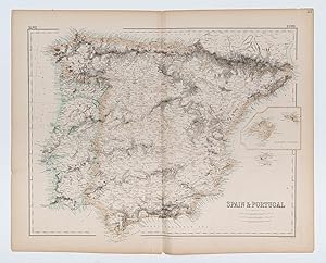
Spain & Portugal.
Verlag: Edinburgh London & DublinA. Fullarton & Co. c., 1862
Anbieter: Robert Frew Ltd. ABA ILAB, London, Vereinigtes Königreich
Verbandsmitglied: ABA ILAB PBFA
Bewertung:
Karte
40.3 x 52.5 cm. Original outline colour. Double page map. Inset map of Majorca and Minorca to the right edge. Tear without loss to lower edge extending up to neatline and affecting imprint, otherwise good.
-
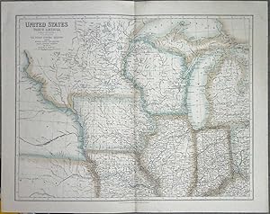
United States: North Central Section (Fullarton 1874)
Verlag: Archibald Fullerton, UK, 1874
Buch Erstausgabe
Softcover. Zustand: Very Good. Calvin, Smith & Tanner (illustrator). First Edition. An original 1874 hand-coloured lithograph taken from Fullarton's Royal Illustrated Atlas, 1874. Depicts Michigan, Illinois, Wisconsin, Iowa, Indiana, Nebraska, Minnesota, and parts of Missouri and Kentucky. Overall a very presentable copy, with some very minor spotting to margins but minimal encroachment onto the actual print, with lines and colouring remaining clear and bold across the entire surface. No significant edge wear beyond faint toning commensurate with age. deal for framing. Why on Amazon do most sellers not describe their actual book? Buy with confidence and support a genuine Independent Bricks & Mortar Real Bookshop. We are Maynard & Bradley CAMBO & PBFA(now lapsed) members here in Leicester City Centre. Size: 570 x 460 mm. 1 pages. Item Type: Book. Illustrator: Calvin, Smith & Tanner. Quantity Available: 1. Shipped Weight: Under 1 kilogram. Category: Geography & Maps; Britain/UK; 19th century; Pictures of this item not already displayed here available upon request. Inventory No: 10647.
-
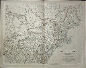
United States: North Eastern States (Fullarton 1874)
Verlag: Archibald Fullerton, UK, 1874
Buch Erstausgabe
Softcover. Zustand: Very Good. Calvin, Smith & Tanner (illustrator). First Edition. An original 1874 hand-coloured lithograph taken from Fullarton's Royal Illustrated Atlas, 1874. Depicts Maine, New Hampshire, Vermont, New york, Massachusetts, Rhode Island, Connecticut, New Jersey, Delaware, Pennsylvania, Maryland, Ohio, Virginia, and Michigan. Overall a very presentable copy, with some very minor spotting to margins but minimal encroachment onto the actual print, with lines and colouring remaining clear and bold across the entire surface. Some very minor nicks to edges, not imposing substantially upon the image, reinforced with high-quality conservaiton tape. deal for framing. Why on Amazon do most sellers not describe their actual book? Buy with confidence and support a genuine Independent Bricks & Mortar Real Bookshop. We are Maynard & Bradley CAMBO & PBFA(now lapsed) members here in Leicester City Centre. Size: 570 x 460 mm. 1 pages. Item Type: Book. Illustrator: Calvin, Smith & Tanner. Quantity Available: 1. Shipped Weight: Under 1 kilogram. Category: Geography & Maps; Britain/UK; 19th century; Pictures of this item not already displayed here available upon request. Inventory No: 10648.