
Gesamtpreis (1 Artikel Artikel):
Versandziel:

WIT, FREDERIC DE (24 Ergebnisse)
Direkt zu den wichtigsten Suchergebnissen
Produktart
- Alle Produktarten
- Bücher (6)
- Magazine & Zeitschriften
- Comics
- Noten
- Kunst, Grafik & Poster (14)
- Fotografien
- Karten (4)
-
Manuskripte &
Papierantiquitäten
Zustand
Einband
Weitere Eigenschaften
- Erstausgabe (2)
- Signiert
- Schutzumschlag
- Angebotsfoto (20)
- Kein Print-on-Demand
Land des Verkäufers
Verkäuferbewertung
-
![Bild des Verkäufers für OASE 98: Narrating Landscape (Journal for Architecture / Tijdschrift Voor Architectuur) by Pousin, Frederic, Vogt, GĂĽnter [Paperback ] zum Verkauf von booksXpress](https://pictures.abebooks.com/inventory/md/md30556513957.jpg)
Soft Cover. Zustand: new.
Mehr Angebote von anderen Verkäufern bei AbeBooks
Neu ab EUR 30,57
-
Women's Strength Training Anatomy Your Illustrated guide to shape and Tone Abs-Back-Legs-Buttocks
Verlag: Human Kinetics Publishers, Champaign, Illinois, U.s.a., 2003
ISBN 10: 0736048138ISBN 13: 9780736048132
Buch Erstausgabe
Glossy Stiff Card Covers. Zustand: Very Good+. Profusely illustrated wit pictures and drawings. (illustrator). 1st. A very good book. Like new. Stiff, glossy covers and glossy pages. . The binding is excellent and there are no markings inside or out. Profusely illustrated with coloured and B & W photos and drawings. "Your illustrated guide to shape and Tone Abs-Back-Legs-Buttocks." There are 135 pages.
-
Strength Training Anatomy Your Illustrated Guide to Muscles at Work
Verlag: Human Kinetics Publishers, Champaign, Illinois, U.s.a., 2001
ISBN 10: 0736041850ISBN 13: 9780736041850
Buch Erstausgabe
Glossy Stiff Card Covers. Zustand: Very Good+. Profusely illustrated wit pictures and drawings. (illustrator). 1st. A very good book. Like new. Stiff, glossy covers and glossy pages. . The binding is excellent and there are no markings inside or out. Profusely illustrated with coloured and B & W photos and drawings. "Your Illustrated Guide to Muscles at Work." There are 124 pages.
-
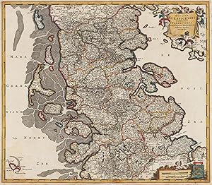
Ducatus Slesvicensis in omnes suas Praefecturas Circulos et Provincias.
Verlag: Amsterdam, 1680
Anbieter: Antiquariat Reinhold Berg eK Inh. R.Berg, Regensburg, Deutschland
Bewertung:

Karte
Original antique copper engraving hand colored in outline and wash when published. Old colored map of the Duchy of Schleswig by Frederick de Wit. Shows northern Schleswig-Holstein and southern Denmark. With Kiel, Flensburg, Schleswig, Husum, Sonderburg, Aabenraa, Hadersleben, Ribe and the islands of Nordstrand, Pellworm, Föhr, Sylt, Romo and Fanö. A beautiful title cartouche at the top right. Frederik de Wit (* 1610; 1698), also Frederic, Frederick or Fredericus, was a Dutch publisher, engraver and cartographer. He founded his company in 1648, at the height of the Golden Age in Amsterdam, and was editor of world atlases from around 1670. His first published map was that of Denmark in 1659. This was followed by a world map from 1660. Further dating of his atlases is difficult. They appeared from 1670 and included 17 to 190 maps. The nautical atlases included 27 nautical charts and appeared from 1675.In 1666 he acquired various engraving plates from Hubertus Quellinus (1619 87) from Antwerp, including a depiction of the new town hall in Amsterdam. He also purchased numerous cards from the Ottens brothers and sold some to them himself. His Atlas of the Netherlands Nieuw kaertboeck van de The "Stedeboeken" (city books that contained panoramas, detailed views and city maps) only appeared from 1695, at a time when his son had taken over the business. The idea probably came from the father and company founder.The family business flourished under the management of the company founder's son, Frederik de Wit (* 1630; 1706 in Amsterdam). He became one of the most important publishers of maps and atlases of his time. Through his marriage to the Amsterdam citizen Maria van der Waag, he acquired the city's civil rights in 1661. Three years later he was admitted to the Guild of St. Lucas. Although he was subject to certain prejudices as a Catholic and did not always have an easy time in the early Calvinist Netherlands of the 17th century, his name was found on the city list of "good men" (a kind of lay judge or lay judge - a position of trust) from 1694 to 1704 the city government).After the decline of the printing houses of Joan Blaeu and Jan Jansson, which had dominated the market until then, de Wit acquired a large number of valuable copper printing plates at auctions, with which he produced, among other things, the two editions of the Stedeboeken of the Netherlands published from 1698, 124 city maps and views of the first Edition and 128 of the second. The city books of Europe with 132 city maps and views were mainly Jansson copper plates, which de Wit had purchased from the Jansson-Waesberg company[4]. These included the old plates from Braun en Hogenberg Civitates Orbis Terrarum, which gave de Wit the opportunity to reprint these too.Soon de Wit was able to deliver almost every type of cartography: from nautical maps and atlases to city maps and city panoramas. His work was characterized by a particularly fine engraving and a noble color design, which make his works interesting to this day, which were reproduced in large numbers and represent a high value in their originals. Until his death, he lived on Amsterdam's Kalverstraat in his house called "De Witte Pascaert" (the white nautical chart).His son and heir Frederik de Wit continued to run the company after his father's death from 1706, but sold a large part of the copper printing plates in 1708 - probably for financial reasons. In 1721 the company passed to Covens & Mortier. This meant that card production moved from the Netherlands, which had dominated this field of work for decades, to France.The output of the House of Wit was consequently oriented towards the north. It was already like this with the ancient Greeks, but then in the Middle Ages there came a phase in which the east was at the top of world maps, because in the east was the holy city of Jerusalem. The word "orientate" comes from this time: Orient is the East, whoever orients himself, and thus his inner map, points to the East. The north-south axis became established in cartography, because only with the advent of the great seafarers and with the introduction of the compass (which we also owe to the Arabs, who in turn got it from the Chinese) did a change occur. The compass needle pointing from north to south contributed significantly to the fact that the maps were aligned accordingly. The publisher was one of the first in Europe to consistently implement this. (Wikipedia) In excellent condition. 49 x 56 cm (19.25 x 22 inches).
-

Circuli Saxoniae Superiori (sic) pars meridionalis in qua sunt Ducatus Saxoniae, Comitatus Mansfeldiae et Voitlandiae.
Verlag: Amsterdam,, 1750
Anbieter: libreria antiquaria perini Sas di Perini, Verona, VR, Italien
Bewertung:

Kunst / Grafik / Poster
Incisione in rame, colorata d'epoca ai confini, mm. 495x575. Ben conservata, con dello sporco superficiale al margine sinistro e una piccola crepa nella battuta visibile solo in controluce. Nr.cat: 100_6897.
-
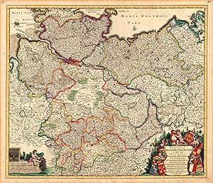
Circulus Saxoniae, Inferioris in quo sunt Ducatus Holsatiae, Meklenburgi, Lauwendurgi, Luneburgi, Brunsuigi, Bremae et Ferdae, Comitatus Dannebergi, Archiepiscopatus Maegdenburgensis, Episcopatus Hildesiae et Halberstad Per F. de Wit.
Verlag: de Wit, Amsterdam, 1680
Anbieter: Antiquariat Reinhold Berg eK Inh. R.Berg, Regensburg, Deutschland
Bewertung:
Karte
Other. Copper engraving, hand colored in outline when published. This antique map shows us lower Saxony in Germany. Inside the map are also the neighbouring regions engraved as Westfalia, Luneburg, Meklenburg, Bremen, etc. In the right lower corner we found the figurative title cartouche. The figuratives hold the singles coast of arms from the singles regions. In the left lower corner we see also a figurative title cartouche with the mileage scale. Near the centerfold one is crease slightly visible else in excellent condition. 495 by 575mm (19˝ by 22ľ inches). 495 by 575mm (19˝ by 22ľ inches).
-
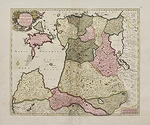
Ducatuum Livoniae et Curlandiae, nova tabula descripta. Divisa et edita.
Verlag: Amsterdam, 1680
Anbieter: libreria antiquaria perini Sas di Perini, Verona, VR, Italien
Bewertung:
Kunst / Grafik / Poster
Incisione in rame, mm 420x510, dipinta a mano d'epoca. Fascinosa carta di Estonia e Lettonia in bella coloritura con restauri integrativi e rinforzi alla piega centrale, alcuni altri punti rinforzati in carta cina a caudsa dell'ossidazione del colore.Copper engraving, mm 420x510, original colour. Decorative map of the Baltic region, covering Estonia and the northern part of Latvia. Intop left corner a cartouche with coats-of-armsSome restorations with manuscript insertions and reinforcements at centerfold Nr.cat: 6678.
-
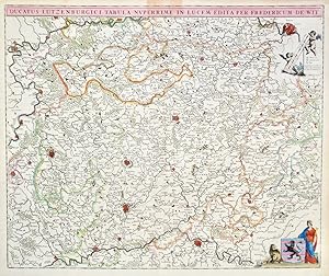
Ducatus Lutzenburgici tabula nuperrime in lucem edita.
Verlag: Amsterdam, 1710
Anbieter: libreria antiquaria perini Sas di Perini, Verona, VR, Italien
Bewertung:
Kunst / Grafik / Poster
Incisione in rame, finemente colorata a mano, mm 470x560. Due bei cartigli figurati negli angoli di destra. Tratta da "Atlas sive Descriptio Terrarum Orbis". De Wit fu uno dei pi? noti cartografi della seconda met? del '600; acquistÚ molte lastre da Blaeu e Jansonius, producendo molti atlanti. Esemplare ottimo, con minimo rinforzo alle estremit? della piega centrale e piccolo alone in alto. Nr.cat: P6150025.
-

ComtČ et gouvernement general de Provence.
Verlag: Amsterdam, 1680
Anbieter: libreria antiquaria perini Sas di Perini, Verona, VR, Italien
Bewertung:
Kunst / Grafik / Poster
Incisione in rame, colorata d'epoca a tutto campo, 490x600. Bel cartiglio allegorico in basso a sinistra che riporta anche la scala delle miglia. Tratta da "Atlas sive Descriptio Terrarum Orbis". De Wit fu uno dei pi? noti cartografi della seconda met? del '600, acquistÚ molte lastre da Blaeu e Jansonius producendo molti atlanti. Esemplareottimo, brunitura in corrispondenza di Freiuls, lieve alone al margine in basso, piccolo restauro alla parte inf. lungo la piega centrale; margini brevi eccetto quello inferiore. Nr.cat: 100_6882.
-

Reipublicae Genuensis et Ducatus Mediolanensis Parmensis et Montsferrati Novissima Descriptio
Verlag: Amsterdam,, 1680
Anbieter: libreria antiquaria perini Sas di Perini, Verona, VR, Italien
Bewertung:
Kunst / Grafik / Poster
Incisione in rame, dipinta a mano d'epoca, mm 495x575. Decorativa carta di Liguria, Piemonte e Lombardia in splendida coloritura a tutto campo, abbellita da cartiglio con stemmi regionali. De Wit (1629-1706) fu uno dei pi? noti cartografi della seconda met? del '600; nacque a Gouda ma svolse l'attivit? ad Amsterdam dal 1648; dal 1660 acquistÚ molte lastre da Blaeu e Jansonius, producendo molti atlanti. Alla sua morte le lastre vennero acquistate da Pierre Mortier, che si associÚ poi a Covens formando una delle pi? grandi case cartografiche olandesi del 18? secolo.Copper engraving, original hand colour, mm 495x575. Decorative map of the Republic of Genoa, and Dutchies of Milan, Parma and Montisferrati and contiguous regions. De Wit (1629 ca.-1706) was a mapmaker and mapseller who was born in Gouda but who worked and died in Amsterdam. From the 1660s onward, he published atlases with a variety of maps. After Frederik's death in 1706, most of the plates went to Pieter Mortier, whose firm eventually became Covens & Mortier, one of the biggest cartography houses of the eighteenth century. Nr.cat: 0310.
-
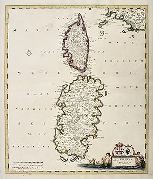
Insularum Sardiniae et Corsicae descriptio
Verlag: Amsterdam, 1680
Anbieter: libreria antiquaria perini Sas di Perini, Verona, VR, Italien
Bewertung:
Kunst / Grafik / Poster
Incisione in rame, colorata d'epoca, 575x490. Buon esemplare con alcuni restauri. Nr.cat: Cod 3423.
-
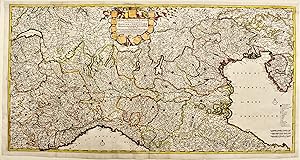
Accuratissima Dominii Veneti in Italia. Ducatus Parmae. Placentiae Modenae Regii et Mantuae episcopatusque Tridentini tabula quae est Lombardia inferior per F. De Wit Amftelodami.
Verlag: Amsterdam, 1680
Anbieter: libreria antiquaria perini Sas di Perini, Verona, VR, Italien
Bewertung:
Kunst / Grafik / Poster
Incisione in rame, finemente colorata a mano d'epoca a tutto campo, mm 500x615. Elegante cartiglio figurato nell'angolo sup. sin. Tratta da "Atlas sive Descriptio Terrarum Orbis". De Wit fu uno dei pi? noti cartografi della seconda met? del '600; acquistÚ molte lastre da Blaeu e Jansonius, producendo molti atlanti. Splendido esemplare in ottimo stato di conservazione e splendida coloritura Nr.cat: P2210003.
-
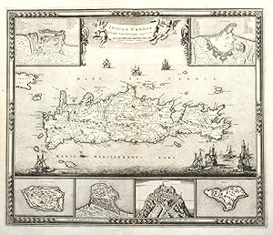
Insula Candia ejusque fortificatio.
Verlag: Amsterdam, 1680
Anbieter: libreria antiquaria perini Sas di Perini, Verona, VR, Italien
Bewertung:
Kunst / Grafik / Poster
Incisione in rame, mm 470x555, firmata in basso nella cornice "Gedruckt tot Amsterdam by Frederick de Wit inde Kalverstraat inde Witte Paskaert ". Elegante cartiglio figurato al centro. Due riquadri in alto e quattro in basso raffiguranti fortezze e citt? dell'isola: Canea, Candia, Spina Longa, Retimno, Thine e Suda. La carta si basa su quella di Sebastien de Pontault de Beaulieu, che qualche anno prima eseguĎ numerosei disegni di fortezze del mediterraneo. Tratta da "Atlas sive Descriptio Terrarum Orbis". De Wit fu uno dei pi? noti cartografi della seconda met? del '600; acquistÚ molte lastre da Blaeu e Jansonius, producendo molti atlanti. Splendido esemplare in ottimo stato di conservazione eccettuata una traccia di tarlo nei margini laterali. Map of Crete with six insets showing the fortifications of Canea, Candia Spina Longa, Retimo, Thine and Suda. Based on the cartography of Sebastien de Pontault de Beaulieu, who mapped a lot of Mediterranean fortifications approx. anno 1674. On the map a lot of informations of roads, towns and topography.Copper engraving, mm 470x555. Six insets with plans of Canea/ Chania, Candia/Iralkion, Spina Longa, Retimo, Thine and Suda. decorative banner title held by two cherubs at top and nice bordure. It is based on the cartography of Sebastien de Pontault de Beaulieu, who mapped a lot of Mediterranean fortifications approx. anno 1674. Dark Impression, very good conditio except some minor worming in outer margins. From "Atlas sive Descriptio Terrarum Orbis".De Wit was one of the most prominent and successful map engravers and publishers in Amsterdam in the period following the decline of the Blaeu and Jansson establishments, from which he acquired many copper plates when they were dispersed at auction.His output covered most aspects of map making: sea charts, world atlases, an atlas of the Netherlands, 'town books' covering plans of towns and cities in the Netherlands and Europe, and wall maps.Frederick de Wit was born in Gouda near Amsterdam in 1648 and by 1654 he had opened a printing office and shop under the name "De Drie Crabben" (the Three Crabs) which was also the name of his house on the Kalverstraat. In 1655, De Wit changed the name of his shop to the "Witte Pascaert" (the White Chart). Under this name De Wit and his firm became internationally known.Dating De Wit's atlases and maps is considered difficult because usually no dates were recorded on the maps and their dates of publication extended over many yearsZacharakis:3714/2392.
-

Novisssima et accuratissima totius Italiae Corsicae et Sardiniae descriptio.
Verlag: Norimberga,, 1710
Anbieter: libreria antiquaria perini Sas di Perini, Verona, VR, Italien
Bewertung:
Kunst / Grafik / Poster
Incisione in rame incisa da J. B. Homann pubblicata da David Funck, colorata d'epoca, 495x575. Non comune edizione della carta di De Wit, originariamente stampata ad Amsterdam nel 1680 ca. Copperplate, original colour, 495x575, engraved by J. B. Homann, published by David Funck; an uncommon late edition of the De Wit map, originally published in c.1680. A good example. Nr.cat: 1319.
-
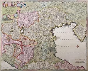
Sedes Belli in Italia comprehendens Respublicas Venetam et Genuensem, Mediolanensem Ducatum Statum DucumÖ
Verlag: Amsterdam, 1700
Anbieter: libreria antiquaria perini Sas di Perini, Verona, VR, Italien
Bewertung:
Kunst / Grafik / Poster
Incisione in rame su due fogli uniti, mm 490x970, colorata. Elegante cartiglio figurato al centro. Questa versione della carta fu pubblicata da De Wit in occasione della guerra di Successione Spagnola, utilizzando le precedenti carte del Dominio veneto e del Piemonte, qui unite, con relative variazioni della lastra nel titolo, ad alcuni toponimi ed al cartiglio. Tratta da "Atlas sive Descriptio Terrarum Orbis". De Wit fu uno dei pi? noti cartografi della seconda met? del '600; acquistÚ molte lastre da Blaeu e Jansonius, producendo molti atlanti. Ottimo esemplare. Sanfelici-Zanasi. Terre di Langobardia, la "Lombardia", il corso del Po e il Ducato Estense, n. 22. Nr.cat: Cod 3273.
-
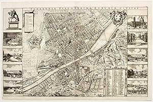
Florentia pulcherrima Etruriae civitas
Verlag: Amsterdam/L'Aia, 1690
Anbieter: libreria antiquaria perini Sas di Perini, Verona, VR, Italien
Bewertung:
Kunst / Grafik / Poster
Due fogli incisi in rame uniti, mm 445x360 ogni foglio. Splendida pianta topografica rialzata arricchita da dieci vedutine con scorci principali della citt? Tratta da "Theatrum praecipuarum totius Europae urbium". Ottimo esemplare con le normali tracce di pieghe,visibili solo al verso, leggermente rinforzate da carta cina.Mori-Boffito, p. 63 e p. 70, segnala che l'autore della pianta in origine Ë il pittore incisore di Praga, Wenzel Hollar, che verso il 1660, prese a modello l'incisione di Stefano Bonsignori del 1584. La veduta dell'Hollar viene riedita ad Amsterdam nel 1700 da Frederick de Wit; la stessa lastra si trova anche nell'Historia fiorentina di Giovanni Michele Bruto e nel Thesaurus antiquitatum et historiarum Italiae di Giovanni Giorgio Grevio, Leida 1723. Nr.cat: 3675.
-
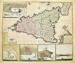
Regni et Insulae Siciliae typus correctissimus ex auctoribus et relationibus novissimis excerptus per F. De Wit.
Verlag: Amsterdam, 1680
Anbieter: libreria antiquaria perini Sas di Perini, Verona, VR, Italien
Bewertung:
Kunst / Grafik / Poster
Incisione in rame, dipinta a mano díepoca, mm 495x590. Seconda e pi? rara versione della Sicilia, in cui líisola appare correttamente orientata, in confronto con la prima versione dove appariva con la punta ruotata verso il basso di circa 40? In basso sono posti dei riquadri con le piante di Milazzo, Palermo e Catania e veduta di Trapani, in alto vi Ë una veduta di Messina. Tratta da ěAtlas sive Descriptio Terrarum Orbisî. De Wit fu uno dei pi? noti cartografi della seconda met? del ë600, acquistÚ molte lastre da Blaeu e Jansonius producendo molti atlanti. Esemplare con qualche normale ossidazione del tempo, alcuni restauri conservativi a crepe dovute allíossidazione del colore, rifilata alla cornice ma con margini in carta antica aggiunti. Valerio, Spagnolo, "Sicilia 1477-1861, La collezione Spagnolo-Patermo in quattro secoli di cartografia", n? 58 Nr.cat: Cod 5765.
-
Insula sive Regnum Siciliae urbibus praecipuis exornatum.
Verlag: Amsterdam,, 1680
Anbieter: libreria antiquaria perini Sas di Perini, Verona, VR, Italien
Bewertung:
Kunst / Grafik / Poster
Incisione in rame, stupendamente colorata a mano, di mm 495x590. In basso sono posti dei riquadri con le piante di Messina, Milazzo, Palermo e Catania e veduta di Trapani. Tratta da "Atlas sive Descriptio Terrarum Orbis". De Wit fu uno dei pi? noti cartografi della seconda met? del '600, acquistÚ molte lastre da Blaeu e Jansonius producendo molti atlanti. Esemplare ottimo, con lieve traccia di sporco superficiale all'angolo sinistro superiore. Restauro alla piega centrale, a qualche strappetto e ai bordi della battuta. Buoni i margini.
-
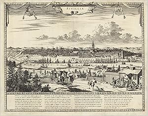
Sivillia - Sevilla
Verlag: Frederic de Wit, Amsterdam, 1695
Anbieter: Antiquariat Reinhold Berg eK Inh. R.Berg, Regensburg, Deutschland
Bewertung:
Karte
Other. Original copper engraving, uncolored when published. This antique plan depicts the bird eye view from the city of Sevillia with the town wall and the surrounding. On the top are the coat of arms from Sevillia and Spain. At the bottom of the map with detailled text descriptions in Dutch, French, German and Latin. Minor marginal skillful restaurations in the paper, else in very good condition. A strong impression. 405 by 516mm (16 by 20Ľ inches).
-
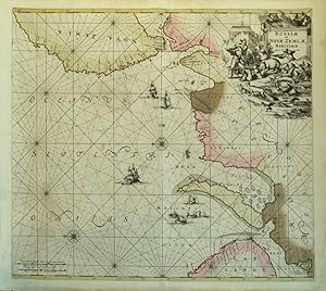
Russiae et Novae Zemlae Maritimae
Verlag: Amsterdam, 1675
Anbieter: Antipodean Books, Maps & Prints, ABAA, Garrison, NY, USA
Verbandsmitglied: ABAA ANZAAB ESA ILAB
Bewertung:

Hand colored copper plate engraved decorative sea chart of the Russian Arctic, oriented east, from De Wit's 'Orbis Maritimus ofte Zee Atlas'. Original color with the green beautifully toned brown, to confirm original color. Showing Mare Album and Lap Landt at the lower right, and Nova Zemla at the top. With a highly decorative cartouche at the upper right, with a hunting scene of funny looking polar bears and walrus; compass roses and rhumb lines. The oceans include several sailing ships as well as whaling ships, whaling long boats and two whales. Image size: 22 1/4 x 19 1/2". Paper size: 24 1/2 x 21". Light damp marks at margins, no where near the image, very good condition.
-
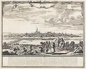
Wien
Verlag: F. de Wit, Amsterdam, 1690
Anbieter: Antiquariat Reinhold Berg eK Inh. R.Berg, Regensburg, Deutschland
Bewertung:
Karte
Other. Original copper engraving, uncolored when published. The engraving is shown the view of Vienna. At the top is a cartouche with the german name of the city,Wien . At the bottom of the map with detailled text descriptions in Dutch, French, German and English. In excellent condition. 405 by 505mm (16 by 20 inches).
-
Insula sive Regnum Siciliae urbibus praecipuis exornatum et novissime editum
Verlag: Amsterdam, 1680
Anbieter: libreria antiquaria perini Sas di Perini, Verona, VR, Italien
Bewertung:
Kunst / Grafik / Poster
Incisione in rame, dipinta finemente d'epoca a tutto campo, 500x600. Una fra le pi? scenografiche, spettacolari e ricercate carte dell'isola, dominata dalla grande veduta generale di Messina in alto a sinistra, mentre nella fascia inf. vi sono quattro inserti delle citt? di Milazzo, Palermo, Catania e Trapani. Splendido esemplare marginoso in splendida coloritura strettamente coeva. Nr.cat: 1743.
-
LES // METAMORPHOSES // D'OVIDE, // EN LATIN, // TRADUITES EN FRANÇOIS, // AVEC DES REMARQUES, // ET DES // EXPLICATIONS HISTORIQUES. // PAR MR. L'ABBE BANIER,// DE L'ACADEMIE ROYALE DES INSCRIPTIONS // ET BELLES LETTRES. // Ouvrage enrichi de Figures en taille douce, // Gravées par B. PICART, & autres habiles Maitres. // TOME PREMIER [and ] [SECOND] // [vignette] // A AMSTERDAM. 2 volumes in one. First edition.
Verlag: Amsterdam : Printed for the Wetsteins and Smith, MDCCXXXII. [1732], 1732
Zustand: Good. Folio. . Contemporary roan with gilt spine, worn along edges of spine, but tight Pages fresh and crisp. Very good. Bookplates and old ink inscription of previous private owners on inside front cover. 30 x 48.5 cm. Text in French and Latin. . See collation below.OCLC only lists the English language edtion of the same year.References : Brunet III: 599; Cohen de Ricci: 768. .In -folio relié pleine basane brune, dos ŕ nerfs orné et doré (Reliure de l'époque). [5] ff., 247 pp., [1] f., (249 254) pp., [2] ff. Orné d'un frontispice, une vignette armoriée de dédicace et de 130 figures in texte ŕ mi-page d'aprčs Lebrun, Leclere, Maas, Picard, Punt, J. Romain, Tosca, de Wit and Vandelaar par divers sculpteurs. Edition bilingue francol-atine imprimée sur 2 colonnes. Bon état, oxydation des ff. et rousseurs, usures ŕ la reliure.


![Bild des Verkäufers für LES // METAMORPHOSES // D'OVIDE, // EN LATIN, // TRADUITES EN FRANÇOIS, // AVEC DES REMARQUES, // ET DES // EXPLICATIONS HISTORIQUES. // PAR MR. L'ABBE BANIER,// DE L'ACADEMIE ROYALE DES INSCRIPTIONS // ET BELLES LETTRES. // Ouvrage enrichi de Figures en taille douce, // Gravées par B. PICART, & autres habiles Maitres. // TOME PREMIER [and ] [SECOND] // [vignette] // A AMSTERDAM. 2 volumes in one. First edition. zum Verkauf von Wittenborn Art Books](https://pictures.abebooks.com/inventory/md/md31259491077.jpg)