
Gesamtpreis (1 Artikel Artikel):
Versandziel:

army map service u s (122 Ergebnisse)
Direkt zu den wichtigsten Suchergebnissen
Suchfilter
Produktart
- Alle Product Types
- Bücher (76)
- Magazine & Zeitschriften (Keine weiteren Ergebnisse entsprechen dieser Verfeinerung)
- Comics (Keine weiteren Ergebnisse entsprechen dieser Verfeinerung)
- Noten (Keine weiteren Ergebnisse entsprechen dieser Verfeinerung)
- Kunst, Grafik & Poster (Keine weiteren Ergebnisse entsprechen dieser Verfeinerung)
- Fotografien (Keine weiteren Ergebnisse entsprechen dieser Verfeinerung)
- Karten (46)
- Manuskripte & Papierantiquitäten (Keine weiteren Ergebnisse entsprechen dieser Verfeinerung)
Zustand Mehr dazu
- Neu (Keine weiteren Ergebnisse entsprechen dieser Verfeinerung)
- Wie Neu, Sehr Gut oder Gut Bis Sehr Gut (31)
- Gut oder Befriedigend (54)
- Ausreichend oder Schlecht (3)
- Wie beschrieben (34)
Einband
Weitere Eigenschaften
- Erstausgabe (14)
- Signiert (Keine weiteren Ergebnisse entsprechen dieser Verfeinerung)
- Schutzumschlag (Keine weiteren Ergebnisse entsprechen dieser Verfeinerung)
- Angebotsfoto (46)
- Keine Print-on-Demand Angebote (122)
Sprache (3)
Gratisversand
- Kostenloser Versand nach Deutschland (Keine weiteren Ergebnisse entsprechen dieser Verfeinerung)
Land des Verkäufers
Verkäuferbewertung
-
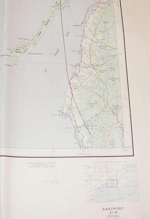
Eastport, Canada and United States Map sheet 21B 1:250,000
Verlag: U.S. Army Map Service, 1974
Anbieter: Nigel Smith Books, Gunnislake, Vereinigtes Königreich
Verkäuferbewertung 5 von 5 Sternen

Karte
EUR 5,91
Währung umrechnenEUR 14,29 für den Versand von Vereinigtes Königreich nach DeutschlandAnzahl: 1 verfügbar
In den WarenkorbMap. Zustand: Fair. Flat map, which has been folded; some annotation to SE corner of map (appears to be pencil) over the NS coast, else in good condition.
-

India and Pakistan. Leh. Sheet NI 43-8,
Verlag: Washington,, 1962
Sprache: Englisch
Anbieter: Books and Beaches, Anna Bechteler, Icking, Deutschland
Verkäuferbewertung 5 von 5 Sternen
Erstausgabe
EUR 18,00
Währung umrechnenEUR 3,90 für den Versand innerhalb von/der DeutschlandAnzahl: 1 verfügbar
In den WarenkorbZustand: Sehr gut. Folding Map 1: 250.000. Very good condition. Uncommon. Showing the area of Leh/Ladakh. Sprache: Englisch Gewicht in Gramm: 50.
-
India and Pakistan. Simla. Sheet NH 43-4,
Verlag: Washington, n.d. (ca. 1960)., 1960
Sprache: Englisch
Anbieter: Books and Beaches, Anna Bechteler, Icking, Deutschland
Verkäuferbewertung 5 von 5 Sternen
EUR 18,00
Währung umrechnenEUR 3,90 für den Versand innerhalb von/der DeutschlandAnzahl: 1 verfügbar
In den WarenkorbZustand: Sehr gut. Folding Map 1: 250.000. As new condition. Uncommon (may be later printing, but not noted as such). Showing the area of Simla. Sprache: Englisch Gewicht in Gramm: 50.
-
India and Pakistan. Mastuj. Sheet NJ 43-13,
Verlag: Washington, n.d. (ca. 1960)., 1960
Sprache: Englisch
Anbieter: Books and Beaches, Anna Bechteler, Icking, Deutschland
Verkäuferbewertung 5 von 5 Sternen
EUR 18,00
Währung umrechnenEUR 3,90 für den Versand innerhalb von/der DeutschlandAnzahl: 1 verfügbar
In den WarenkorbZustand: Sehr gut. Folding Map 1: 250.000. As new condition (may be later printing, but not noted as such). Uncommon. Showing the area of Mastuj on the border to Afghanistan. Sprache: Englisch Gewicht in Gramm: 50.
-
India and Pakistan. Palampur. Sheet NI 43-16,
Verlag: Washington, n.d. (ca. 1960)., 1960
Sprache: Englisch
Anbieter: Books and Beaches, Anna Bechteler, Icking, Deutschland
Verkäuferbewertung 5 von 5 Sternen
EUR 18,00
Währung umrechnenEUR 3,90 für den Versand innerhalb von/der DeutschlandAnzahl: 1 verfügbar
In den WarenkorbZustand: Sehr gut. Folding Map 1: 250.000. As new condition (may be later printing, but not noted as such). Uncommon. Showing the area of Palampur in Kangra Valley/Himachal Pradesh. Sprache: Englisch Gewicht in Gramm: 50.
-
India and Pakistan. Shyok. Sheet NH 44-5,
Verlag: Washington, n.d. (ca. 1960)., 1960
Sprache: Englisch
Anbieter: Books and Beaches, Anna Bechteler, Icking, Deutschland
Verkäuferbewertung 5 von 5 Sternen
EUR 18,00
Währung umrechnenEUR 3,90 für den Versand innerhalb von/der DeutschlandAnzahl: 1 verfügbar
In den WarenkorbZustand: Sehr gut. Folding Map 1: 250.000. As new condition (may be later printing, but not noted as such). Uncommon. Showing the area of Shyok in Ladakh, with Lingzi Tang, Changlung La, Panglung. Sprache: Englisch Gewicht in Gramm: 50.
-
India and Pakistan. Mastuj. Sheet NJ 43-13,
Verlag: Washington, n.d. (ca. 1960)., 1960
Sprache: Englisch
Anbieter: Books and Beaches, Anna Bechteler, Icking, Deutschland
Verkäuferbewertung 5 von 5 Sternen
EUR 18,00
Währung umrechnenEUR 3,90 für den Versand innerhalb von/der DeutschlandAnzahl: 1 verfügbar
In den WarenkorbZustand: Sehr gut. Folding Map 1: 250.000. As new condition (may be later printing, but not noted as such). Uncommon. Showing the area of Mastuj on the border to Afghanistan. Sprache: Englisch Gewicht in Gramm: 50.
-
India and Pakistan. Phari Dzong. Sheet NG 45-4,
Verlag: Washington,, 1960
Sprache: Englisch
Anbieter: Books and Beaches, Anna Bechteler, Icking, Deutschland
Verkäuferbewertung 5 von 5 Sternen
EUR 20,00
Währung umrechnenEUR 3,90 für den Versand innerhalb von/der DeutschlandAnzahl: 1 verfügbar
In den WarenkorbZustand: Sehr gut. Colour folding Map 1: 250.000. As new condition (may be later printing, but not noted as such). Uncommon. Showing the area of Phari with parts of Eastern Bhutan, Tashigang, Tagye, Kyungdu to Taga Dzong. Sprache: Englisch Gewicht in Gramm: 50.
-
India and Pakistan. Shimshal. Sheet NJ 43-15,
Verlag: Washington, n.d. (ca. 1960)., 1960
Sprache: Englisch
Anbieter: Books and Beaches, Anna Bechteler, Icking, Deutschland
Verkäuferbewertung 5 von 5 Sternen
EUR 20,00
Währung umrechnenEUR 3,90 für den Versand innerhalb von/der DeutschlandAnzahl: 1 verfügbar
In den WarenkorbZustand: Sehr gut. Colour Folding Map 1: 250.000. As new condition (may be later printing, but not noted as such). Uncommon. Showing the area of Kashmir / Tibet Border with Khunjerab River, Shimshal Pass, Chikar, Koktash. Sprache: Englisch Gewicht in Gramm: 50.
-
India and Pakistan. Srinagar. Sheet NI 43-6,
Verlag: Washington, n.d. (ca. 1960)., 1960
Sprache: Englisch
Anbieter: Books and Beaches, Anna Bechteler, Icking, Deutschland
Verkäuferbewertung 5 von 5 Sternen
EUR 20,00
Währung umrechnenEUR 3,90 für den Versand innerhalb von/der DeutschlandAnzahl: 1 verfügbar
In den WarenkorbZustand: Sehr gut. Folding Map 1: 250.000. As new condition. Uncommon (may be later printing, but not noted as such). Showing the area of Kashmir with Srinagar. Sprache: Englisch Gewicht in Gramm: 50.
-
Double-sided AAF Escape Charts: Eastern Asia Series AMS 5301 - NI53 Osaka, Japan (2nd Edition, 1943) / NI54 Tokyo, Japan (2nd edition, 1943)
Verlag: US Army American Air Force (AAF), Washington DC, 1943
Sprache: Englisch
Anbieter: Dendera, London, Vereinigtes Königreich
Verkäuferbewertung 5 von 5 Sternen
Karte
EUR 17,74
Währung umrechnenEUR 18,37 für den Versand von Vereinigtes Königreich nach DeutschlandAnzahl: 1 verfügbar
In den WarenkorbNo Binding. Zustand: Poor. Two WW2 era American Air Force escape maps / evasion charts, 1/1M, colour printed on each side of a sheet of balloon cloth, rayon, or silk, 65x62cm. The cloth is fine, but the printing is unfortunately poor: legible but faint on the Osaka side, and faint with large illegible areas on the Tokyo side.
-
Carte ( Map ) BESANCON , GRAY , SAÔNE , France : For Use By War and Navy Departement Agencies Only , Not for Sale or Distribution
Verlag: U.S. ARMY, Washington, 1943
Sprache: Französisch
Anbieter: Au vert paradis du livre, AUMES, LR, Frankreich
Verkäuferbewertung 5 von 5 Sternen
Karte
EUR 30,00
Währung umrechnenEUR 12,90 für den Versand von Frankreich nach DeutschlandAnzahl: 1 verfügbar
In den WarenkorbPas de couverture. Zustand: Parfait État . Perfect State . 1° Édition , First Edition. Carte au 1:100 000° ( Sheet 12 L ) . Editées pour le débarquement des Alliés Américains et Anglais et pour le parachutage des soldats sur les zones occupés par les Allemands pendant la 2° guerre mondiale , ces cartes sont quadrillées pour permettre la triangulation des points en surveillance aérienne . Elles comportent des légendes détaillées en français et anglais se référant ŕ un vocabulaire géographique mais aussi les lignes de transmission , les sources , les lignes de chemin de fer et la largeur des routes ( Nombreuses autres légendes ) . Au dos un quadrillage pour les formations . Archives impressionnantes et émouvantes de cette gigantesque machine qui s'était mise en marche , y compris dans la construction des barges de débarquement et des ponts pour matériel lourds , tanks etc , pour la liberté . Cusey , St Andoche , Bucey les Traves , Foręt de Belle Vaivre , Foręt de Chailluz , Ruffey-le-Château , Dammartin , Mirebeau-sur-Bčze , Fontaine Française , etc . Aviation . Rare . 67 cm X 50 cm . Envoi en rouleau . Histoire 2° Guerre Mondiale . - 250 gr.
-
Carte ( Map ) DAX , ORTHEZ , HAGETMAU , Pyrénées Atlantiques , France : For Use By War and Navy Departement Agencies Only , Not for Sale or Distribution
Verlag: U.S. ARMY, Washington, 1944
Sprache: Französisch
Anbieter: Au vert paradis du livre, AUMES, LR, Frankreich
Verkäuferbewertung 5 von 5 Sternen
Karte
EUR 30,00
Währung umrechnenEUR 12,90 für den Versand von Frankreich nach DeutschlandAnzahl: 1 verfügbar
In den WarenkorbPas de couverture. Zustand: Parfait État . Perfect State . 1° Édition , First Edition. Carte au 1:100 000° ( Sheet 12 L ) . Editées pour le débarquement des Alliés Américains et Anglais et pour le parachutage des soldats sur les zones occupés par les Allemands pendant la 2° guerre mondiale , ces cartes sont quadrillées pour permettre la triangulation des points en surveillance aérienne . Elles comportent des légendes détaillées en français et anglais se référant ŕ un vocabulaire géographique mais aussi les lignes de transmission , les sources , les lignes de chemin de fer et la largeur des routes ( Nombreuses autres légendes ) . Au dos un quadrillage pour les formations . Archives impressionnantes et émouvantes de cette gigantesque machine qui s'était mise en marche , y compris dans la construction des barges de débarquement et des ponts pour matériel lourds , tanks etc , pour la liberté . , Pouillon , Pomaro , Amou , Lagor , Sauveterre , Le Gave de Pau , Peyrehorade , Bidache , L'Adour , etc . Aviation . Rare . 67 cm X 50 cm . Envoi en rouleau . Histoire 2° Guerre Mondiale . - 250 gr.
-
Carte ( Map ) VIERZON, France : For Use By War and Navy Departement Agencies Only , Not for Sale or Distribution
Verlag: U.S. ARMY, Washington, 1943
Sprache: Französisch
Anbieter: Au vert paradis du livre, AUMES, LR, Frankreich
Verkäuferbewertung 5 von 5 Sternen
Karte
EUR 30,00
Währung umrechnenEUR 12,90 für den Versand von Frankreich nach DeutschlandAnzahl: 1 verfügbar
In den WarenkorbPas de couverture. Zustand: Parfait État . Perfect State . 1° Édition , First Edition. Carte au 1:100 000° ( Sheet 12 L ) . Editées pour le débarquement des Alliés Américains et Anglais et pour le parachutage des soldats sur les zones occupés par les Allemands pendant la 2° guerre mondiale , ces cartes sont quadrillées pour permettre la triangulation des points en surveillance aérienne . Elles comportent des légendes détaillées en français et anglais se référant ŕ un vocabulaire géographique mais aussi les lignes de transmission , les sources , les lignes de chemin de fer et la largeur des routes ( Nombreuses autres légendes ) . Au dos un quadrillage pour les formations . Archives impressionnantes et émouvantes de cette gigantesque machine qui s'était mise en marche , y compris dans la construction des barges de débarquement et des ponts pour matériel lourds , tanks etc , pour la liberté . St Viatre , Nouan le fuzeler , Pierrefite sur Sauldre , Clémont , Argent sur Sauldre , Blancafort , Cernoy-en-Berry , Aubigny , Les Aix d'Angillon , Neuvy sur Barangeon , Vierzon , La Ferté Imbault , Nançay , Souesmes , etc . Aviation . Rare . 67 cm X 50 cm . Envoi en rouleau . Histoire 2° Guerre Mondiale .- 250 gr.
-

Sheet X - 5 Weilheim. For use by War and Navy Department Agencies only. Not for sale or distribution.
Verlag: Washington: Selbstverlag, 1943
Sprache: Englisch
Anbieter: Antiquariat im Kloster, Weilheim, BY, Deutschland
Verkäuferbewertung 5 von 5 Sternen
Karte Erstausgabe
EUR 45,00
Währung umrechnenEUR 6,00 für den Versand innerhalb von/der DeutschlandAnzahl: 1 verfügbar
In den WarenkorbFaltmaß 34x24 cm. Zustand: Gut. First Edition. AMS 2. Mehrfarb. Faltkarte im Maßstab: 1:100.000. 99x91 cm. Karte 55x71 cm. - Karte etw. angeschmutzt, mit Randknicken u. Randläsuren u. einzelnen Eintragungen. - Aufgrund der Größe der Karte konnte diese nicht vollständig gescannt werden. Zahlungen mit PayPal möglich. Sprache: Englisch Gewicht in Gramm: 200.
-
Map Buinaksk, Caucasia 1: 253,440, GSGS 4213
Verlag: Army Map Service, U. S. Army, Washington DC, 1944
Anbieter: Stony Hill Books, Madison, WI, USA
Verkäuferbewertung 5 von 5 Sternen
EUR 23,08
Währung umrechnenEUR 30,16 für den Versand von USA nach DeutschlandAnzahl: 1 verfügbar
In den WarenkorbUnbound. Zustand: Very Good. Individual map Buinaksk section, Caucasia, 1:253,440, Sheet G 5; First Middle East Edition AMS 2, dated 1944, sheet size 26 x 20 inches, printed in 3 colors; ex-libris but with minimal markings only on the margins. Map is marked "For use by War and Navy Department Agencies only / Not for sale or distribution" during World War II. Very Good condition, light edge rubs, map is flat never folded.
-
Map Kirov-Abad, Caucasia 1:253,440, IDR 543/5443
Verlag: Army Map Service, U. S. Army, Washington DC, 1943
Anbieter: Stony Hill Books, Madison, WI, USA
Verkäuferbewertung 5 von 5 Sternen
EUR 23,08
Währung umrechnenEUR 30,16 für den Versand von USA nach DeutschlandAnzahl: 1 verfügbar
In den WarenkorbUnbound. Zustand: Very Good. Individual map Kirov-abad section, Caucasia, 1:253,440, Sheet G 8; First Edition AMS 1, dated 1943, sheet size 26 x 22 inches, printed in 3 colors; ex-libris but with minimal markings only on the margins. Map is marked "For use by War and Navy Department Agencies only / Not for sale or distribution" during World War II. Very Good condition, light edge rubs, map is flat never folded.
-
Bethel, United States ( Alaska Topographic Map, 1:1,000,000).
Verlag: U. S. Army Map Service, Corps of Engineers, Folded Sheet.
Anbieter: Eryops Books, Stephenville, TX, USA
Verkäuferbewertung 5 von 5 Sternen
Karte
EUR 2,22
Währung umrechnenEUR 38,78 für den Versand von USA nach DeutschlandAnzahl: 1 verfügbar
In den WarenkorbFolded topographic map; ex-corporate library; minor shelfwear; o/w in very good condition. Map.
-
Barrow, United States ( Alaska Topographic Map, 1:1,000,000).
Verlag: U. S. Army Map Service, Corps of Engineers, Folded Sheet.
Anbieter: Eryops Books, Stephenville, TX, USA
Verkäuferbewertung 5 von 5 Sternen
Karte
EUR 2,22
Währung umrechnenEUR 38,78 für den Versand von USA nach DeutschlandAnzahl: 1 verfügbar
In den WarenkorbFolded topographic map; ex-corporate library; minor shelfwear; o/w in very good condition. Map.
-
Umiat, North America ( Alaska Topographic Map, 1:1,000,000).
Verlag: U. S. Army Map Service, Corps of Engineers, Folded Sheet.
Anbieter: Eryops Books, Stephenville, TX, USA
Verkäuferbewertung 5 von 5 Sternen
Karte
EUR 3,11
Währung umrechnenEUR 38,78 für den Versand von USA nach DeutschlandAnzahl: 1 verfügbar
In den WarenkorbFolded topographic map; ex-corporate library; minor shelfwear; o/w in very good condition. Map.
-
Molukken Islands, Soela Sheet No. 1 (S133-E12410/50X220), AMS T561
Verlag: Army Map Service, US Army, Washington DC, 1943
Anbieter: Crouch Rare Books, Godalming, Vereinigtes Königreich
Verkäuferbewertung 5 von 5 Sternen
Karte
EUR 23,65
Währung umrechnenEUR 19,06 für den Versand von Vereinigtes Königreich nach DeutschlandAnzahl: 1 verfügbar
In den Warenkorbsheet overall dimensions 510 x 1115 mm (landscape), scale 1:250,000; inset 'Sketch indicating the way the terrain was surveyed; the anchorages for the ships of K. P. M. and other large steamers, and a diagram of the low tide current close to the coast, based upon information obtained from the native population and local native sailors. Additional Information: The detail surveys, starting out from the coast line survey on Soela Sanana, were composed of observations from great distances along the coast, observing at sea towards known points along the shore and known hill and mountain tops. The altitudes were measured with an aneroid barometer, others were determined by the compass clinometer, others with level compass.' Legend includes: 'Surveyed with the compass clinometer; Measured by pacing-off and with the Smalkalder compass; estimated distances and boussole compass measurements; Surveys done by the mining engineer, Dr. H. A. Brouwer, azimuthal declination .; Anchorages for the ships of the Royal Dutch Steampacket Navigation Co.; Direction of current; Whirl currents; At high tide the direction of the current is reverse, as indicated on the map.' 'Surveyed by the First Lieutenant of Infantry, P. van Halstyn, and the native surveyor, third class, Latamentik, and compiled by the former, further completed with information obtained from the military commander of Amboina & Ternate'. This map appears to have been originally compiled for The Reproduction Division of the Topographical Sirvice, Weltevreden, 1918. A simplified reprint produced in 1927 forms the basis for this map, grid and projection added by the Army Map Service, 1943. 'For use by War and Navy Department Agencies only. Not for sale or distribution.' an attractive map which would be suitable for mounting/framing if required. Note: This is an original map. We do not sell reproductions or facsimiles.
-
White Lake, World (North America). Scale 1:1,000,000. (United States / U. S. Army Map Service, Map NH 15).
Verlag: U. S. Army Map Service., 1958
Anbieter: Eryops Books, Stephenville, TX, USA
Verkäuferbewertung 5 von 5 Sternen
EUR 3,53
Währung umrechnenEUR 38,78 für den Versand von USA nach DeutschlandAnzahl: 1 verfügbar
In den WarenkorbNo Binding. Zustand: Good. Large Folded Map; ex-corporate library; light creasing of edges, o/w in good condition. Map.
-
Florida Keys, Sheet NG 17, Series 1301, World (North America). Scale 1:1,000,000. (United States / U. S. Army Map Service, Map NG 17).
Verlag: U. S. Army Map Service., 1959
Anbieter: Eryops Books, Stephenville, TX, USA
Verkäuferbewertung 5 von 5 Sternen
EUR 3,53
Währung umrechnenEUR 38,78 für den Versand von USA nach DeutschlandAnzahl: 1 verfügbar
In den WarenkorbNo Binding. Zustand: Very Good. Large Folded Map; ex-corporate library; in very good condition. Map.
-
Carte ( Map ) DIJON , SAINT SEINE L'ABBAYE , France : For Use By War and Navy Departement Agencies Only , Not for Sale or Distribution
Verlag: U.S. ARMY, Washington, 1944
Sprache: Französisch
Anbieter: Au vert paradis du livre, AUMES, LR, Frankreich
Verkäuferbewertung 5 von 5 Sternen
Karte
EUR 35,00
Währung umrechnenEUR 12,90 für den Versand von Frankreich nach DeutschlandAnzahl: 1 verfügbar
In den WarenkorbPas de couverture. Zustand: Parfait État . Perfect State . 1° Édition , First Edition. Carte au 1:100 000° ( Sheet 12 L ) . Editées pour le débarquement des Alliés Américains et Anglais et pour le parachutage des soldats sur les zones occupés par les Allemands pendant la 2° guerre mondiale , ces cartes sont quadrillées pour permettre la triangulation des points en surveillance aérienne . Elles comportent des légendes détaillées en français et anglais se référant ŕ un vocabulaire géographique mais aussi les lignes de transmission , les sources , les lignes de chemin de fer et la largeur des routes ( Nombreuses autres légendes ) . Au dos un quadrillage pour les formations . Archives impressionnantes et émouvantes de cette gigantesque machine qui s'était mise en marche , y compris dans la construction des barges de débarquement et des ponts pour matériel lourds , tanks etc , pour la liberté . , Chaume , Aignay le Duc , Grancey-le-château , Cuzon-sur-Coulange , Occey , Chazeuil , Labergement-Foigney , Dijon , Fauverney , Ste Marie sur Ouche , Chailly-Armançon , Marigny-le-Cahouet , Ménétreux-le-Pitois , etc . Aviation . Rare . 67 cm X 50 cm . Envoi en rouleau . Histoire 2° Guerre Mondiale . - 250 gr.
-

Carte ( Map ) LAC DE NEUFCHATEL . PONTARLIER , France : For Use By War and Navy Departement Agencies Only , Not for Sale or Distribution
Verlag: U.S. ARMY, Washington, 1943
Sprache: Französisch
Anbieter: Au vert paradis du livre, AUMES, LR, Frankreich
Verkäuferbewertung 5 von 5 Sternen
Karte
EUR 35,00
Währung umrechnenEUR 12,90 für den Versand von Frankreich nach DeutschlandAnzahl: 1 verfügbar
In den WarenkorbPas de couverture. Zustand: Parfait État . Perfect State . 1° Édition , First Edition. Carte au 1:100 000° ( Sheet 12 L ) . Editées pour le débarquement des Alliés Américains et Anglais et pour le parachutage des soldats sur les zones occupés par les Allemands pendant la 2° guerre mondiale , ces cartes sont quadrillées pour permettre la triangulation des points en surveillance aérienne . Elles comportent des légendes détaillées en français et anglais se référant ŕ un vocabulaire géographique mais aussi les lignes de transmission , les sources , les lignes de chemin de fer et la largeur des routes ( Nombreuses autres légendes ) . Au dos un quadrillage pour les formations . Archives impressionnantes et émouvantes de cette gigantesque machine qui s'était mise en marche , y compris dans la construction des barges de débarquement et des ponts pour matériel lourds , tanks etc , pour la liberté . Chantran , Bois de la Rappe , Echevanne , Arc sous Cicon , Morteau , Le Locle , Neufchâtel , Grandson , Payerné , Cugy , Orbe , Mouthe , etc . Aviation . Rare . 67 cm X 50 cm . Histoire 2° Guerre Mondiale . Envoi en rouleau . - 250 gr.
-
Carte ( Map ) NEVERS , France : For Use By War and Navy Departement Agencies Only , Not for Sale or Distribution
Verlag: U.S. ARMY, Washington, 1943
Sprache: Französisch
Anbieter: Au vert paradis du livre, AUMES, LR, Frankreich
Verkäuferbewertung 5 von 5 Sternen
Karte
EUR 35,00
Währung umrechnenEUR 12,90 für den Versand von Frankreich nach DeutschlandAnzahl: 1 verfügbar
In den WarenkorbPas de couverture. Zustand: Parfait État . Perfect State . 1° Édition , First Edition. Carte au 1:100 000° ( Sheet 12 L ) . Editées pour le débarquement des Alliés Américains et Anglais et pour le parachutage des soldats sur les zones occupés par les Allemands pendant la 2° guerre mondiale , ces cartes sont quadrillées pour permettre la triangulation des points en surveillance aérienne . Elles comportent des légendes détaillées en français et anglais se référant ŕ un vocabulaire géographique mais aussi les lignes de transmission , les sources , les lignes de chemin de fer et la largeur des routes ( Nombreuses autres légendes ) . Au dos un quadrillage pour les formations . Archives impressionnantes et émouvantes de cette gigantesque machine qui s'était mise en marche , y compris dans la construction des barges de débarquement et des ponts pour matériel lourds , tanks etc , pour la liberté . , Chaumoux Marcilly , St Léger le Petit , La Loire , St Pierre Le Moutier , Sancoins , L'Allier , etc . Aviation . Rare . 67 cm X 50 cm . Envoi en rouleau . Histoire 2° Guerre Mondiale . - 250 gr.
-
Map Lung-ch'i, China City Plans 1:12,500, A.M.S. L901
Verlag: Army Map Service, U. S. Army, Washington DC, 1946
Anbieter: Stony Hill Books, Madison, WI, USA
Verkäuferbewertung 5 von 5 Sternen
EUR 26,63
Währung umrechnenEUR 30,16 für den Versand von USA nach DeutschlandAnzahl: 1 verfügbar
In den WarenkorbUnbound. Zustand: Very Good. Individual map Lung-ch'i (Chang-chou, Fukien province), China City Plans 1:12,500, Type C - AMS 2, dated 1946, sheet size 26 x 22 inches, printed in multiple colors; ex-libris but with minimal markings only on the margins. Map is marked "For use by War and Navy Department Agencies only / Not for sale or distribution" during World War II. Very Good condition, light edge rubs, map is flat never folded.
-
Map Jarkent, Western Asia 1:1,000,000, A.M.S. 5302
Verlag: Army Map Service, U. S. Army, Washington DC, 1943
Anbieter: Stony Hill Books, Madison, WI, USA
Verkäuferbewertung 5 von 5 Sternen
EUR 26,63
Währung umrechnenEUR 30,16 für den Versand von USA nach DeutschlandAnzahl: 1 verfügbar
In den WarenkorbUnbound. Zustand: Very Good. Individual map Jarkent section, Western Asia 1:1,000,000, Sheet NL-44; First Edition, dated 1943, sheet size 25 x 25 inches, printed in up to 5 colors; ex-libris but with minimal markings only on the margins. Map is marked "For use by War and Navy Department Agencies only / Not for sale or distribution" during World War II. Very Good condition, light edge rubs, nice wide margins; shows border between Kazakh A.S.S.R. and China, map is flat never folded.
-
Map Aleksandrovsk, Eastern Asia 1:1,000,000, AMS 5301
Verlag: Army Map Service, U. S. Army, Washington DC, 1944
Anbieter: Stony Hill Books, Madison, WI, USA
Verkäuferbewertung 5 von 5 Sternen
EUR 26,63
Währung umrechnenEUR 30,16 für den Versand von USA nach DeutschlandAnzahl: 1 verfügbar
In den WarenkorbUnbound. Zustand: Very Good. Map of Aleksandrovsk section, Eastern Asia 1:1,000,000, AMS 5301, sheet NM 54, 55; First Edition Revised 1944, sheet size 24 x 26 inches, printed in up to 6 colors; ex-libris but with minimal markings only on the margins; map is marked "For use by War and Navy Department Agencies only / Not for sale or distribution" during World War II. Includes the mainland Russia and southern part of Sakhalin island, with USSR / Japan boundary, map is flat never folded.
-
[Mapa de] CHOISEUL ISLAND, Melanesia
Verlag: Army Map Service, 1944
Anbieter: Librería Miguel Miranda, Lope de Vega n.ş XIX, Madrid, M, Spanien
Verkäuferbewertung 4 von 5 Sternen

Karte
EUR 45,00
Währung umrechnenEUR 10,95 für den Versand von Spanien nach DeutschlandAnzahl: 1 verfügbar
In den WarenkorbZustand: Good / Bien. Washington: Army Map Service, [ca. 1959?].- Mapa en colores plegado de 64,5 x 55 cm, Scale 1: 500.000; Refer to this map as: SHEET SB 57-4 Series X401; Texto en inglés. Tan solo tiene los nombres de algunos pueblos o zonas costeras manuscritos a bolígrafo azul. Por lo demás en perfecto estado. Book in english GEOGRAFÍA, GUÍAS Y ATLAS DEL EXTRANJERO.


![Bild des Verkäufers für [Mapa de] CHOISEUL ISLAND, Melanesia zum Verkauf von Librería Miguel Miranda](https://pictures.abebooks.com/inventory/md/md31942268035.jpg)